Objectives
Upon completion of Section 1,
students should be able to:
◆identify the major physical
characteristics of England;
◆explain why London became
one of the world’s greatest
com-mercial and shipping centers;
◆describe how the Industrial
Revo-lution affected Britain’s economic
activities.
National Geography
Standards
The following National Geography
Standards are highlighted in this
section: 1, 3, 5, 8, 9, 11, 12, 14,
16, 17
Bellringer
Ask students:
How do you think
a small island nation such as
Great Britain came to control
a global empire that stretched
from Africa to Asia and included
Australia and territory in the
Americas?
Lead a discussion of
why Great Britain was able to
con-trol a worldwide empire.
L E S S O N P L A N
1.
Focus
Have students turn
the subheadings in this section
into questions using the words
what, where, how,
and when.
Then, as they read the section,
have them answer the questions.
2.
Instruct
Write these words
on the board: Atlantic Ocean,
Thames River, Pennine Chain,
Low-lands, Midlands.
Have students use
the text to write one or two
sen-tences explaining how each of
these places is related to the
eco-nomic development of England.
3.
Close/Reteach
Ask
stu-dents to identify how Britain is
combating its recent economic
problems. As a class, brainstorm
other ways that Britain could
im-prove its economy.
T
T
he many islands clustered off the north-west coast of Europe are called the British Isles. The largest island in the British Isles— and in all of Europe—is Great Britain.The island of Great Britain comprises three for-merly independent countries: England, Scotland, and Wales. Together with Northern Ireland, they form the United Kingdom of Great Britain and Northern Ireland, or simply the United Kingdom. The core of the United Kingdom is England. Notice from the population map on page 297 that England is the most densely populated area in the British Isles. Nearly 80 percent of the region’s population live here.
England’s Physical
Characteristics
“Our England is a garden,” declared English poet Rudyard Kipling in the late 1800s. Kipling was describing rural England with its green, rolling meadows, peaceful rivers, and neat farms. The English landscape is actually made up of three
Reading Focus
• What major physical characteristics can be found in different regions of England, and how do they affect the economy? • Why did London become one of the
greatest commercial and shipping centers in the world?
• How did the Industrial Revolution change and expand economic activities in the United Kingdom?
Key Terms
England
1
1
Main
Idea
Resources, trade, and industrial innovation helped the small nation of Britain to become a global economic power.
Physical Characteristics
Rich soil and a moderateclimate contribute to lush gardens in southwestern Great Britain.
fertile
ore
tertiary economic activity
very different areas: the Highlands, Midlands, and Lowlands.
The Highlands are a band of hills running the length of England’s west coast. Older and harder rock formations in this region have been worn down by centuries of weathering. Even so, some peaks rise to 3,000 feet (900 m), and the land is difficult to farm.
A short distance to the southeast are the Mid-lands. Here lie the thick veins of coal that fueled the country’s Industrial Revolution. Factory towns such as Birmingham, Manchester, and Stoke-on-Trent still darken the air with fumes from their mills. Heavy industrial development means that some of England’s highest population densities are in the Midlands.
To the south and east are the rolling Lowlands. The land slopes gently toward the English Chan-nel, and elevations rarely top 1,000 feet (300 m). Younger, softer rocks lie beneath the land’s sur-face. Because these rocks break up easily, soil in the Lowlands tends to befertile—able to produce abundant crops.
Royal Guards, London, England (photo left) Chapter 15 ■Section 1 305
S
ection
1
pp. 305–309
Religion and Culture
Religion is a significant
driving force in creating patterns of conflict
and cooperation among people. It influences
peoples’ beliefs, values, traditions, behavior,
and worldview. In Europe, as in other parts of
the world, many modern political tensions
have their origins in historical events related
to culture and religion—events shaped by
geographic processes like diffusion and
migration. The geography of religion
pro-vides insights into past events and can help
us understand present conditions.
From A Master Teacher
T E A C H I N G T I P
Pacing Suggestions
For 90-minute Blocks
You will want to vary activities.
• Complete page 17 of the Creative Teaching
Activi-ties booklet in the Teaching Resources with the
class. Explain that a culture hero reflects the
val-ues of the culture that created him or her. Tell
students to hypothesize about the values of the
societies that created the culture heroes in the
lesson. Have students write paragraphs that
sum-marize their ideas, and ask volunteers to share
their paragraphs with the class.
Word Origin
Liverpool
Liverpool was a tidal
creek that existed where the city is
now located. Liverpool
means “pool
of thick water.”
Understanding the Past
The British Empire
From 1890
to 1920 when their empire was at its
largest, Britons could brag that “the
sun never sets on the British Empire”:
It encompassed a fifth to a quarter
of the earth’s land surface and
con-sidered more than a quarter of the
world’s population its subjects.
Alternative
Assessment
Introduce the Activity
Participating in a Cooperative
Learning Project
Divide students
into groups of four and ask each
group to choose a country in the
British Isles or a Nordic country and
plan a walking tour of that country.
Distribute the Cooperative Learning
Project Rubrics found on pages 16
and 18 in the Assessment Rubrics for
student reference during the project.
Ben Nevis 4,406 ft. (1,343 m)
Orkney Islands
Shetland Islands
GRAM PIAN MT
S.
PE N N IN
E C H A IN
CA
MB RIA
N MT
S.
Ou te r He
br
i de s
In ne
rH eb
ri
de s
Isles of Scilly
Anglesey
Kinnairds Head Duncansby Head
Holy Island
Isle of Wight Isle of
Man Island of Arran CHEVIOT
HILLS
Channel Islands Start Point
Lizard Point
Land's End
AT L A N T I C O C E A N
North Sea
Irish Sea Solway Firth
Firth of Clyde
Firth of Forth
Humber River
The Wash Moray Firth
North Chann
el
Bristol Channel Cardigan
Bay
Strait of Dover Loch
Ness
Loch Lomond
Lough Neagh
Tweed R.
Shan
non
R.
Thames R.
English
Channel
SaintGe
orge's
Chan
nel The
Min
ch
Cork
Cardiff
Birmingham Bradford
Manchester Leeds Edinburgh
Newcastle Glasgow
Belfast
Aberdeen
Middlesbrough
Dover Portsmouth Newport
Liverpool
Swansea Limerick
Londonderry
Sheffield Nottingham
Bristol
Plymouth
London Dublin
Munster Leinster Connacht
Ulster DistrictLake SCOTLAND
(U.K.)
ENGLAND
(U.K.)
NETHERLANDS
BELGIUM
FRANCE WALES
(U.K.)
NORTHERN IRELAND
(U.K.)
IRELAND
NORWAY
50°N
60°N 60°N
50°N
0° 10°W
10°W 0°
N
S W E
0
0 50 100 km
50 100 mi
The British Isles:
PHYSICAL-POLITICAL
KEY
Lambert Azimuthal Equal-Area Projection
14,000 7,000 1,500 700 (sea level) 0
4,270 2,135 457 213 0 (sea level) Feet Elevation Meters
National capital Major city Mountain
The Lowlands provide England with some of its most productive farms. Farmers grow wheat, veg-etables, and other crops on small plots of land. They set aside larger parcels of land for pasture. The cool, moist weather of England’s marine west coast cli-mate is perfect for raising sheep and dairy and beef cattle. British goods are sold both in the United Kingdom and in other European Union nations.
Rise of London
as a Trade Center
Even before industrialization, England’s farms produced surplus goods for export. Trade within England and with other European nations fos-tered the growth of cities along rivers and the coast. Of these, London was the most important.
Chapter 15 IThe British Isles and Nordic Nations
306
APPLYING THE GEOGRAPHIC THEMES
쎲Regions The British Isles have clearly defined regions of highlands and lowlands.
• Which mountain ranges are the dominant features of the Highlands? • Would you expect farming to be more common in the Highlands or Lowlands?
Explain.
RESOURCE DIRECTORY
Teaching Resources
Unit 4, Chapter 15
• Map/Graph Skills, p. 21
Mental Mapping booklet
• Outline Map, p. 57
Assessment
Assessment Rubrics
• Cooperative Learning Project Rubrics A and B,
pp. 16 and 18
Technology
World Geography Map and Photo Transparencies
• Western Europe: Maps and Photos
Chapter 15
306
B A C K G R O U N D
Answers to Map Caption
Grampian Mountains, Pennine Chain,
Cambrian Mountains
The Lowlands are easier to farm
because of the region’s fertile soil and
rolling flatlands.
Vocabulary
Estuary
Write the term estuary
on
the board. Ask a volunteer to look
up the term in the dictionary and
read its definition aloud. Tell
stu-dents that estuaries where
fresh-water and seafresh-water mix are among
the world’s most productive aquatic
breeding grounds. Ask:
How does
pollution affect an estuary?
(It
changes the natural balance of the
environment, which can result in
the death of fish, birds, and other
wildlife in the estuary, changes in
the reproductive cycles of creatures,
and the destruction of vegetation.)
Critical Thinking
Location and Change
Use the
following questions to help
stu-dents see the changing importance
of location:
Why was London
not a major port before 1500?
(The Mediterranean Sea was the
center of trade, and London was far
west of major trade routes.)
What
increased London’s importance
as a port after 1500?
(Coloniza-tion of the Americas made an
At-lantic location more advantageous.)
How have trade routes changed
since the 1900s?
(The United States
and Japan and other Pacific Rim
countries have become major trade
centers, making the Pacific Ocean a
hub of ocean trade.)
How might
such a shift in trade routes
af-fect London’s relative
advan-tage as a port?
(It would decrease
London’s advantage as a port.)
Why did London, withits inlandlocation,be-come one of the greatest commercial and sh ip-ping cities in the world? The answer can be found in one of the five geographic themes—location.
London’s Relative Location The
map on page 306 shows that although London is only about 70 miles (110 km) from the continent of Europe, the city of Dover is even closer to the mainland. So why isn’t Dover the English capital
of trade? London has a big advantage over Dover and other southern coastal ports. The hills along the English Channel drop sharply, forming steep cliffs that plunge straight down to the water. In contrast, London islocated on the Thames (TEHMZ) River. Since the Thames Valley was formed, the level of the Atlantic Ocean has risen. The result is an estuary—a flooded valley at the wide mouth of a river. Thus, ships could sail di-rectly up to the port of London.
As early as the 1500s, London was a bustling port. One writer described activity along the water-front in this way:
“
A forest of masts. . . . Hugesquare-rigged ships lay side by side, surrounded by barges and small craft. . . . The . . . boats
had to fight . . . to their landing places.
”
Global Trade Patterns The port of
London grew rapidly in the 1500s because of changes in patterns of world settlement and trade. The influence of the Roman Empire meant that theMediterranean Sea traditionallyhad been the center of trade. London remained on the far edge of European trade. In the late 1400s,
however, improved ships and navigational de-vices allowed Europeans to push westward across the Atlantic Ocean. Great Britain’s strategic, cen-trallocation on the Atlantic was ideal for trade. So, as trade across the Atlantic increased, Britain’s relative location improved.
Economic Activities
In the 1500s, Britain shipped mostly the products of its farms. But within its small area, the island nation had the resources to fuel the start of the Industrial Revolution.
As shipowners and merchants earned profits from trade, they looked for new ways to invest their money. Wealthy business owners built fac-tories to produce manufactured goods to sell to Britain’s colonies. As ships
plied the oceans loaded with
British goods, Britain became
known as the “workshop of the world.”
T h e R i s e o f H e av y
Industry Some of the
ear-liest technological advances of the Industrial Revolution were used in factories that pro-duced textiles, or cloth. Brit-ishmanufacturers firstused water power to run spinning
307
Chapter 15 ■Section 1
British Isles, Nordic Nations,
and the United States
British Isles, Nordic Nations,
and the United States
Country
Electricity Consumption
(per capita kilowatt-hours)
Petroleum Imports (thousand barrels per year)
Petroleum Exports (thousand barrels per year)
Denmark Finland Iceland Ireland Norway Sweden United Kingdom United States
Energy Data
5,911 15,152
26,791
5,801 23,414
14,838 5,841
12,574
24,107 79,247
0
25,277 4,747
135,299 387,203
3,338,460
101,036 0
0
0 1,051,395
0 606,039
3,298
Energy Data
Sources: MSN Encarta Encyclopedia
Facts
F
Facts
acts
The Thames River was once so polluted that Britain’s capitol build-ing, the Parliament, had to be equipped with chemical-soaked curtains to keep out the odor. Now anti-pollution efforts have resulted in a river so clean it is again a home to salmon.
CHART SKILLS
쎲Economic Activities Which three nations consume the most electricity per person? How might climate and location contribute to high energy needs in those countries? 쎲Natural Resources Which nation has vast
resources of fossil fuels?
Answers to Chart S
k
ills
Icel
an
d, Fi
n
l
an
d,
an
d S
w
ede
n
; Possible
an
s
w
e
r
: These co
un
t
r
ies
ar
e loc
a
ted i
n
cold cli
ma
tes. I
n
w
i
n
te
r
, they
ma
y
u
se
m
o
r
e elect
r
icity fo
r
he
a
t
an
d light th
an
othe
r
co
un
t
r
ies.
No
rwa
y
A C T I V I T Y
A C T I V I T Y
CUSTOMIZE FOR...
Less Proficient Readers
Visualizing
Read aloud the first paragraph of the
subsection Rise of London as a Trade Center on
the opposite page. Help students pick out phrases
indicating location: “within England,” “along rivers
and the coast.” Have them form mental images of
these phrases and trace the locations on the map.
Encourage students to repeat these steps as they
read the remainder of the subsection.
Group Work
Activity:
Writing an advertisement
Purpose:
Tell each group that its
job is to research, write, and illustrate
an advertisement for a five-stop tour
of England entitled “Birthplace of
the Industrial Revolution.” The tour
should include early industrial
cen-ters, birthplaces of key inventors,
and areas of major resources. Have
students include a map showing the
tour route in their advertisements.
Roles:
Researchers, writers, and
illustrators
Result:
Have a volunteer from
each group present the tour route
to the class and explain why each
place on the tour was included.
Connecting With . . .
Economics
For economic reasons,
many Britons have concerns about
their country’s membership in the
European Union. One complaint is
that the EU’s economic policy would
cost the government too much
money. Another obstacle came in
1996, following the outbreak of
Mad Cow Disease in Britain: The EU
banned the import of British beef
until 1999, heightening tensions
be-tween Britain and the EU. More
re-cently, Britain’s reluctance to accept
the euro stemmed from worries that
the new currency could endanger
Britain’s strong economy.
Summarizing Main Ideas
After students have read the
subsec-tion Challenges to British Industry,
have them write a two-sentence
summary of the subsection’s main
ideas.
machines but later switched to coal as a source of power for the steam engine.
Major coal fields lay along the edges of the Pennine mountain range, as well as in the north-east, near the city of Newcastle. Britain also possessed large reserves of ironore,or rocky material containing a valuable mineral. Inven-tors improved methods of melting iron ore and using it in the production of steel. The towns of Birmingham, Sheffield, and Newcastle grew dramatically in size as nearby coal fields made them centers of manufacturing. Coal supplies were so plentiful that the phrase “carrying coals to Newcastle” developed to describe an unnecessary action.
The Industrial Revolution brought wealth to Britain, but the factories and mines also changed the English landscape. English poet William Blake condemned the “dark, Satanic mills” for spoiling
“England’s green and pleasant land.” A visitor to Birmingham in the early 1800s reported that the noise there was “beyond description,” and the filth was “sickening.”
Challenges to British Industr y
Britain’s plentiful supply of raw materials and its position on major sea routes made it the world’s industrial leader for years. But in the late 1800s, Britain was challenged by two new industrial powers—Germany and the United States. By 1900, both the United States and Germany were mak-ing as much steel as the United Kmak-ingdom.
In recent years, British industry has fallen upon hard times. Much of the area’s coal supply was used up during the Industrial Revolution. Since the 1970s, Britain has turned to oil and gas deposits beneath the floor of the North Sea as a source for fuel.
Chapter 15 ■The British Isles and Nordic Nations 308
Birmingham and
Industry
Migration Birmingham became one of the world’s leading industrial cities dur-ing the 1800s. With workers flooding into Birmingham, the city’s population grew from 70,000 in 1801 to more than 400,000 at the end of the century.
Movement How did this movement of people into cities change the landscape of Great Britain?
308
B A C K G R O U N D
Answer to Photo Caption
As cities grew, the landscape changed
from a “green and pleasant land” to a
noisy, polluted, dirty, urban area.
A C T I V I T Y
R E A D I N G S T R A T E G Y
RESOURCE DIRECTORY
Teaching Resources
Answers to
Section 1 Assessment
1. (a)
fertile, p. 305
(b)
ore, p. 308
(c)
tertiary economic activity, p. 309
2.
The Highlands are the band of
hills running the length of England’s
west coast. To the southeast are the
Midlands, which contain thick veins
of coal. South and east of the Midlands
are the rolling Lowlands, where the
soil is fertile.
3.
Before the 1500s, London was not
a major port because it was far west
of the major trade routes. As trade
across the Atlantic increased, London’s
relative location changed and it
ex-perienced rapid growth as a port city.
4. (a)
Technological advances made
it possible to harness new sources of
energy, such as water power and coal.
Improved methods of melting iron
ore and producing steel led to the
rise of heavy industry.
(b)
Factories
and mines polluted the countryside
with dirt and noise.
5. (a)
Much of Britain’s coal supply
was used up during the Industrial
Revolution.
(b)
Britain has turned to
other sources of fuel and encouraged
the growth of service industries to
offset the loss of heavy industry.
Activity Rubrics
Share rubrics
with students before they write
their paragraph.
Attempted
The paragraph gives
very few valid reasons, contains
fac-tual errors, and is messy or difficult
to read.
Minimal
The paragraph gives
sev-eral valid reasons but contains
fac-tual errors.
Adequate
The paragraph gives a
number of valid reasons, contains
no factual errors, and is well thought
out.
Exemplary
The paragraph
con-tains no factual errors, is perceptive,
and reflects a clear understanding
of how these cities became major
urban centers.
Despite its problems, Britain’s overall economy
has been growing steadily. To offset theloss of
heavy industry, the government has encouraged the growth of tertiary economic activities, or service industries, such as finance, insurance,
and tourism. Inflation rates have beenlow, and
unemployment has been decreasing. Though a member of the European Union, the United King-dom has been reluctant to adopt the euro—the common currency system of the European Union.
1. Key Terms Define(a)fertile, (b)ore, (c)tertiary economic activity.
2. Physical Characteristics Describe the three different physical areas of the English landscape.
3. Global Trade Patterns What geographic fac-tors affected London’s level of development?
4. Economic Activities (a)What impact did tech-nological innovations have on the British econ-omy?(b)What impact did they have on Britain’s physical landscape?
5. Critical Thinking Analyzing Causes and Effects (a) What was the effect of the Industrial Revolution on Britain’s coal supply? (b)How has the British economy recovered from this loss?
SECTION
1
ASSESSMENT
Review the natural resources and political maps in the Regional Atlas for Western Europe and this section. Find the location of England’s chief mineral deposits and the cities of Birmingham, Manchester, and Leeds. Write a paragraph explaining some of the reasons why these cities became major urban centers.
Activity
USING THE
REGIONAL ATLAS
309
Chapter 15 ■Section 1
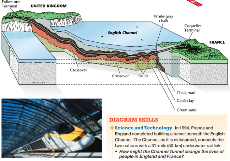
English Channel
Crossover Folkestone
Terminal
Crossover Faults
White-gray chalk
Chalk marl
Gault clay
Green sand UNITED KINGDOM
FRANCE Coquelles
Terminal
World Geography 98
N
Not to scale
The English Channel Tunnel
DIAGRAM SKILLS
쎲Science and Technology In 1994, France and England completed building a tunnel beneath the English Channel. The Chunnel, as it is nicknamed, connects the two nations with a 31-mile (50-km) underwater rail link. • How might the Channel Tunnel change the lives of
people in England and France?