GIS DATABASES WITH APPLICATIONS IN URBAN CADASTRE
CAMELIA SLAVE1, IOANA VIZIREANU2
1.University of Agronomic Sciences and Veterinary Medicine,
Mărăști no 59, Bucharest 011464, Romania
2.National Institute for Aerospace Research "Elie Carafoli" - INCAS ,
Iuliu Maniu, no 220, Bucharest 061126 , Romania
Keywords: Bucharest, cadastre, database, GIS, real estate.
ABSTRACT
In the evolution of societies, the state wanted to know and be informed on the scope, characteristics and distribution of private or public property, from its territory. It was necessary that these areas limits, goods and members are drawn and recorded in the registers. This gives cadastre in order to determine exactly who is the owner of the plot or building. The GIS databases can be created that can be used in survey
This paper presents a GIS database in Bucharest and maps in ArcMap 10.1 which resulted
INTRODUCTION
State ownership of land, in all ages, civilizations and stability based institutions. Property status has transformed over time from a primary form - simple land cover - up to modern forms known today.
Origin of the word - cadastre - would derive from the Latin "capitastrum" which relates to "capitionis registrum" which represent the family head tax (capitatio). The name appears in a form similar, used to mean 1185, a Venetian document, and by the seventeenth century will be imposed throughout Italy under the name - Catastro. Italy passed in France under the name - they land surveying - in Germany and Austria under the name - der cataster.
In terms of comparative law can distinguish two types of terrier, who was settled in a purely tax and that has been established both for tax purposes and legal purposes. The difference between them is based on the concept of ownership and the role of the state towards proving this right.
For a long time cadastre in many countries was a system used only for tax purposes and legal entities. Later it was developed to become a multipurpose cadastre, land registration that is able to provide data on other aspects of the territory, not just those on the land or construction. This added coverage or information on land use and its quality, facilities construction, number of floors and building material on spatial elements.
According to the low of real estate and cadastre (Law No. 7/1996) was adopted the following definition of cadastre: "General cadastre is a unified and mandatory evidence and systematic inventory of real estate throughout the country, in terms of quantity, quality and legal, regardless of their destination and ownership, through which the identification, registration and their representation in the registers and cadastral maps and plans.
MATERIAL AND METHOD
Analele Universităţii din Craiova, seria Agricultură – Montanologie – Cadastru (Annals of the University of Craiova - Agriculture, Montanology, Cadastre Series)Vol. XLV 2015
Baneasa We Dămăroaia, Domains, Dorobanţi, Gara de Nord, Griviţa, Victoria, Tails, pepper, Spring, Chitila and part of the Giulești district. (Figure 1)
The area is bounded in the north highway Bucharest - Ploiesti, in the West Kiseleff (E60) and where it is Herastrau Park and Village Museum "Dimitrie Gussti". Kiseleff Boulevard continues with Poligrafiei Boulevard. At the intersection of the two roads is "Casa Presei" and at the intersection of Prezan Constantin Boulevard with Kiseleff Boulevard is the Arc de Triumf. In the South area is bounded by Street Turda, it intersects with Ion Mihalache Boulevard and Griviţei Way (DN 7). The link between Kiseleff and Griviţei way is by Exposition Boulevard and Clăbucet Street.
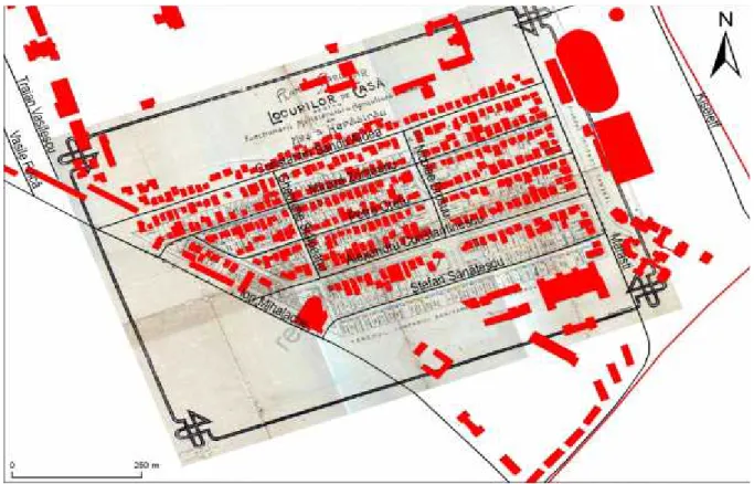
One of the most elegant districts of the capital, Domenii Park was designed for officials of the Ministry of Agriculture and between the wars, starting from the garden city principles. In the meantime, the parcelling suffered a series of changes from the original plan, being closer to what scholars called the early twentieth century-garden suburb, was successfully integrated into the dynamics of Bucharest city.
"What does the ”Domenii” name? In 1884, Parliament provides for administration of the Royal House twelve agricultural areas which were designed "to financially support the royal household and to form centres for the implementation and spread of the latest agricultural techniques of the time."
Figure 1. Map superposition with the original parcelling plan of study area
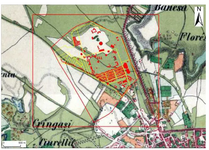
I also used the map entitled Charta Romania Meridional created in 1864, 150 years ago, in 1864 it was made a detailed map about Country Romanian, map title is Charter Meridional Romania contains 112 sheets, often is called by its author: map of Szathmári.
Figure 2. Maps and the southern study area
Rising the between 1855 and 1859 the Austrian terrain - which served as the basis of this chart - was the last and the most detailed of these foreign topography work. Above-mentioned map was drawn up between the union (1859) and independence (1878) Romanian principalities. This map was the first map terrain - in some extent - their own. Following his elevation topography formed Romanian Institute. The Romanian literature has incomplete and sometimes contradictory information about this elevation and topographic map. Only a few sets of sheets can be found in the collections of maps. Map projection used is in Stereo 1970 and has been downloaded from http://www.charta1864.ro/charta.html. (Figure2)
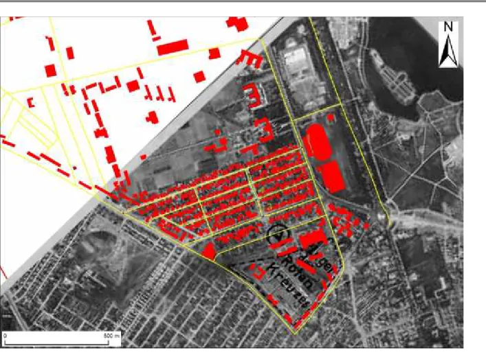
I have used a photogram from 1938 it was georeferention in ArcMap10.1 program. This analysis shows that the villas had been built before the Second World War. The area where today is the University Hospital "Elias" was an area for the Red Cross. On photogram appears as "Roten Creuzes". Photogram was discharged from www.wwii-photos-maps.com/.../Bucuresti%20. (Figure 3)
The database. According to Wikipedia the largest online encyclopaedia -database, sometimes called the "database" is a way of storing information and data on external media (storage device) with the possibility of further expansion and their fast retrieval. Creation of cadastral database. Cadastral database is performed using information technology in the cadastral systems.
Analele Universităţii din Craiova, seria Agricultură – Montanologie – Cadastru (Annals of the University of Craiova - Agriculture, Montanology, Cadastre Series)Vol. XLV 2015
Figure 3.Spatially referenced photogram
- Establishment of the layers of the cadastre database
To establish layers are taken into account the following principles:
- Every enclosure (topographic details category) to represent a single layer;
- On a layer of cadastral entities will be represented a single geometric type of entity; - Each layer is performed only one type of topology;
- For each layer is created in the cadastral database table attribute and relationship of the entity which is the covering cadastral registered.
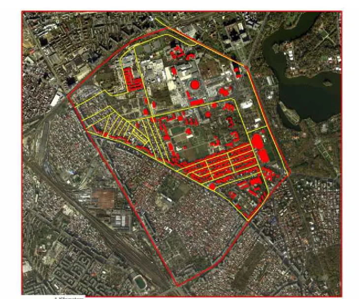
Vectorization of streets and buildings was made after a orthophotomap from the year 2012 (Figure 4)
For the studied area we have created a database in the Arc Catalog. There were a number of 443 vectored buildings on various roads. I tried to identify buildings constructed during the interwar period, although most of them were rebuilt in modern architectural styles.
Inside the perimeter studied we have been identified buildings which are classified as first class seismic risk.
Figure 4.Site map building
CONCLUSIONS
Cadastral works are executed in order to provide those interested, at any time, correct and complete data on immovable property, to contribute to:
•The legal status of their registration of immovable property in the land in order to achieve real estate advertising;
• Creating a base for determining the fiscal tax value;
• Provide the necessary elements for the preparation of studies and projects on land planning and localities for sitting various objectives and socio-cultural nature of the industry;
• Prepare documentation for removing lands out of farming;
• Knowledge and inventory real estate capital - urba and its condition; • Environmental protection;
• Making the necessary cadastral database and information systems of the urban planning. The importance of the general cadastre is that they provide data on immovable property (position, size, use, possession), all activities required substantial national economy.
Since there Cadastre is an important tool provides warranty documents conferring real estate transactions in the market.
Analele Universităţii din Craiova, seria Agricultură – Montanologie – Cadastru (Annals of the University of Craiova - Agriculture, Montanology, Cadastre Series)Vol. XLV 2015
elements sketched on a sheet of paper with symbols that represent physical objects. People who use maps must interpret these symbols. Topographic maps show the shape of the land using contour. Actual shape of the land can only be seen with the mind's eye. Graphic techniques of GIS make visible the relationship between the map, increasing the ability to extract and analyze information. Various maps and satellite information sources can be combined in ways that simulate complex natural system interactions. Through a function known as visualization, a GIS can be used to produce images - not just maps, but representations, animations, sounds and other cartographic products. These images allow specialists to see the objects of their work in ways that were not seen before. The images are often helpful in representing the technical concepts of the subject matter of a GIS for non-technical people
Advantages of Using a GIS: • The data is better organized • Eliminate redundant data storage • Facility update
• Analysis, statistics and much lighter us Search • Users are more productive
Disadvantages • Complexity
• Difficulties in forming personal. It should be noted that a GIS system cannot run a network scenarios ,,what if?" But other applications developed to use GIS databases can run such scenarios.
Technology geographic information systems (GIS) can be used for scientific investigations, resource management and development planning. Applications of GIS areas are countless. I have given examples only from the geo-topography, but GIS is applied in many other areas, such as Health, Social Sciences, banking, forensics, Tourism, Geology, and Environment etc.
BIBLIOGRAPHY
1. Bos Nicolae & Iacobescu Ovidiu. 2009, Cadastru si cartea funciara, Editura C.H.Beck Bucuresti, Romania, pp 159-246;
2. Legea cadastrului și a Publicității Imobiliare (Legea 7/1996) 3. Legeea fondului funciar (Legea 18/1991)
4. www://geo-spatial.org/
5. www. Esri.ro 6. http://www.envi.ro
7. http://OpenStreetMap
8. http://www.charta1864.ro/charta.html
9. http://geoportal.ancpi.ro/geoportal/imobile/Harta.html
10.http://www.pmb.ro/
11.http://www.opengis.org