IJEDR1702094
International Journal of Engineering Development and Research (www.ijedr.org)535
Computation Of Burnt Forest Region Using Digital
Image Processing
1N.Nagapriya, 2 Mrs. S.Yoga 1M.Phil scholar, 2Assistant professor,
Department of Computer Science, Sakthi College of arts and science for women, oddanchatram,, India.
________________________________________________________________________________________________________
Abstract: Predicting the forest fire is an important problem from many points of view. It destroys ecology and decreases the overall life quality. It is important from economical point of view as wood is a valuable resource. Fires not only affect the characteristics of forests but it also affects human lives and livelihood. Due to the lack of collecting the aerial view images of forest fire and also lack of specific techniques for calculation of burnt regions of forests, researchers use different methods. In this paper, we examine the problem of collecting the exact aerial image forest fire detection of different parts of the forest areas. Our approach is based on image pre-processing, segmentation of images are produced using the segmentation methods and compute the burned area. The images are collected from the videos. In the preprocessing phase, forest fire video is converted into frames and stored as images.
Keyword : Theresholding, noise removal, burned region, image scaling
1. INTRODUCTION
Forest fire is one of the most threatening commotions for property, infrastructure and ecosystem. The long vapid and hot summer is responsible for rapid increase in fires with uncontrolled strong wind, results in forest fire and large burnt areas every year. Generally, the wild land fire is initiate through lightening but human negligence is also responsible to burn thousands of square kilo meters. The other important parameter responsible for the burn occur in forest is drying out branches and leaves and become highly flammable. Increment in forest fires not only degrades the modem of forest but also it degrades the human lives and lively hoods. In relation to loss of human lives examples, the forest fires in Victoria, Australia in 2009, which caused 173 fatalities, while fires in Greece in 2007, resulted in 80 dead. Many wilderness urban interface fires have clearly shown how wildfires affect and threaten residential area.
According to precursor, fires acquired in forest will halve the world forest stand before the year 2030. 20% of complete CO2 emission came from forest fires indicates that it is important to deal these phenomenon with great attention. Also the increment in the rate of occurrence of fire is occurred due to the global warming.
Fires affect not only forests and their function and services, but also the other assets that is human lives and livelihoods. The damage can be extend to landscape and results in haze and deposit pollutants as well as the release of greenhouse gases. Presently there is no conventional method to evaluate accurate area of burnt regions of forests and hence researches uses different methods and variables .The main parameter during consideration of computation of burnt regions is speed in performing processes and in damage evaluation. In this report, An aerial digital image which is obtained from forest after the fire occurrence is used to calculate the primary area of burnt regions using digital image processing and to obtain the accurate real area in hectares , coefficient “m” is calculated. This method is dependent on some secondary parameters such as aerial camera and helicopter in order to calculate real area of burnt regions. To obtain accurate and rapid evaluation of burnt regions after the wild land fire suppression is used for the reforestation and restoration in the affected areas and to avoid the post wild fire hazards and degradation of affected areas.
2. LITERATURE SURVEY
Bibek Ranjan Ghosh, Siddhartha Banerjee, Attyuttam Saha, Fire is one of the major problems that are causing great loss to property and ecosystem in today’s world. Fires not only affect the characteristics of forests but it also affects human lives and livelihood. Due to the lack of specific techniques for calculation of burnt regions of forests, researchers use different methods. In this research, an automated approach is developed to determine the significant burnt area of forest using different image processing techniques. The proposed method is compared with other existing methods and is found to be capable in more precise measurement of the burnt area. The proposed method produces much more exact results at a single trial and uses no brute force method to determine a proper filter to determine the exact region affected by the wild fire.
Hamidreza, Hamud and Asadollah proposed a method which uses a hit and trial method using median filters. This method is basically a brute force method to search for a proper median filter that serves the purpose of detecting the actual burnt region. After binarizing the image using the thresholding technique, median filters are being applied. Firstly a median filter of 3×3 dimensions have been used followed with filters of 5×5,7×7 dimensions and finally a proper result is obtained using a filter of 9×9 dimensions.
IJEDR1702094
International Journal of Engineering Development and Research (www.ijedr.org)536
INPUT VIDEO EXTRACT THE
SELECTED FRAME
ACQUISITION OF THE IMAGE FROM
THE EXTRACTED FRAME
BINARIZATION OF THE IMAGE
THERSHOLDING SEGMENTATION
NOISE REMOVAL USING HYBRID MEDIAN FILTERING
IMAGE SCALING AND COMPUTING THE PRIMARY AREA TO GET OVERALL BURNT
REGION
DISPLAY THE BURNT REGION
AND DISPLAY THE BURNT AREA
IN HECTARES
working very fast and can be used for online calculations and decision making. The efficiency of the proposed procedures is shown: 95 % detection ration and 5 % false detection is shown. The proposed method can be used in the monitoring systems of the area to detect fire.
3. METHODOLOGY
Three situations in the forest fire field is encountered.
Pre-Disaster: In this situation, most researches are about the ways that how to prevent the fire using natural posture or using consolidation and integration image based data which are obtained from different satellites sensors.
Meantime-Disaster: In this situation, researches have been focused on the detection of smoke detection of fire primary has
two parameters which are prediction of development of fire and the acceleration in firefighting operation.
Post-Disaster: If firefighting is performed then and then only the calculation of burnt forest region area is possible because the continuation of fire and smoke may disturb the area computing process. Therefore in this situation researches have been focused on burnt area after fire completion.
Fig.1. Overall structure
In this work, computation of burned region in the fire forest consists of four phases such as Acquisition Of Image from Videos
Segmentation Of Image Cancellation Of Noise Image Scaling
Acquisition Of Image
The desired aerial image is obtained from the videos which are taken in Ariel view like using of helicopter and by high resolution camera. From the target point in order to be used in machine vision system, the burnt region will be completely visible in one picture. Extract the exact frame using input videos.
Segmentation Of Image
IJEDR1702094
International Journal of Engineering Development and Research (www.ijedr.org)537
and white image will be in the form of 0 and 1. In thresholding image segmentation technique, consider primary image in the form of the gray degree like T then determination of pixels with less values or more values than T is occur. If gray level of image is greater than T then convert that pixels into white. If gray level of image is less than T then convert that pixel in black pixels. In the binary image of burnt region , the calculation of burnt area becomes easier.Cancellation Of Noise
After segmentation of the images, images may have noise which should be detected and remove before further process. To evaluate area with classified accuracy it is necessary that the obtained noise in the image should be strictly reduced or deleted. Two median and average filters can be useful in the process of noise cancellation. But median filter having greater accuracy than the average filters. We use median filter for implementation in this process. Designation of median filter includes necessity of determined dimensions. The pixel which is placed in the centre of matrix of this filter, arrange data surround to it and select median and then replace the original pixel by median pixel.
Image Scaling
Calculation of primary area after binarization and removal of noise. Now the image which is binary image array consists the value 0 and value1 as image has only two colors black and white where black is burnt region and white is a background. It is easy to count the black pixel. Primary area is calculated by simple integration method. After computing the primary area it is necessity to calculate the coefficient ‘m’ to get overall burnt region. Coefficient can be calculated by applying the imaging scale on the image where, Imaging Scale=focal length of Camera /
Height of flight(h) The coefficient ‘m’ is given by,
m=1/Imaging Scale
Hence the real burnt area can be calculated by simple formula Real area=Primary area*m
By simply calculating the primary area and coefficient ‟m‟ we can get real area. Real area is obtained is in Hectare.
4. RESULTS AND DISCUSSION
Forest fires represent a constant threat to ecological systems, infrastructure and human lives. Past has witnessed multiple instances of forest and wild land fires. Fires play a remarkable role in determining landscape structure, pattern and eventually the species composition of ecosystems. The integral part of the ecological role of the forest fires is formed by the controlling factors like the plant community development, soil nutrient availability and biological diversity. Fires are considered as a significant environmental issue because they cause prominent economic and ecological damage despite endangering the human lives.
In the proposed method image captured from the fire forest video as input, process the image and performs forest region detection and computation of burned region.
Fig.2. Extraction of frames from video
Selected fire forest video file is loaded and determine the frame count. Initially is extracted from the video with mean value of gray level, red level, green level and blue level. Extracted frames are stored in the folder with frame number as file name. Computation of mean value of Red, green and blue levels and plot the graph is also processed in this phase. it will automatically updates the progress of the frame extraction.
IJEDR1702094
International Journal of Engineering Development and Research (www.ijedr.org)538
Fig.3. Selected image from frameThe desired aerial image is prepared in order to be used in machine vision system using of a helicopter (or plane) and by an appropriate digital camera from the target point, the burnt region as connected and completed inside one picture, according to above figure.
The desired aerial image is selected from the extracted frame from the fire forest video which one is taken from the helicopter.
Fig. 4 Binaryzation of the Image
Binarization of the image is one of the effective ways of segmentation in order to draw the burnt regions. The simplest method for this is "Thresholding". An image with gray degrees (between 0 and 255) can be converted into a binary image (black and white or 0 and 1). To do thresholding technique, first consider a gray degree like T in the primary image and then, determining some pixels which have the values less and/or more than T [11]:
Converted into white pixels -> Gray level > T and Converted into black pixels -> Gray level <T
Now, in the calculation of area becomes easier in the binary image of the burnt region in the above figure.
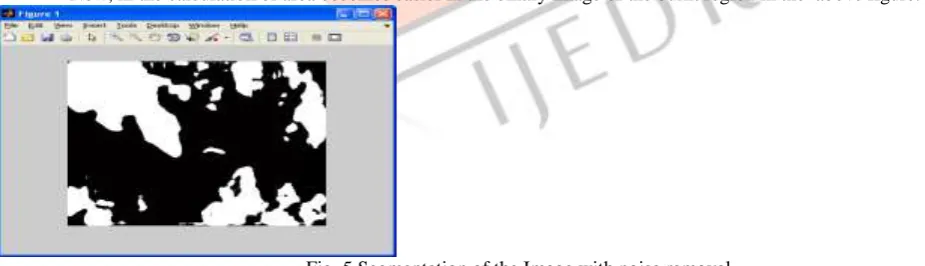
Fig. 5 Segmentation of the Image with noise removal
IJEDR1702094
International Journal of Engineering Development and Research (www.ijedr.org)539
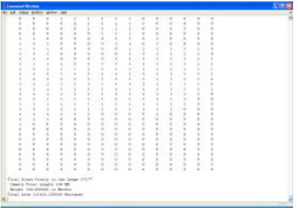
Fig. 6. Burned Region CalculationsThe available burnt region in above figures is a binary image array consisting of values of 0s and 1s. In fact, this image has two colors of black (the burnt region) and white (background). It is enough to count the number of black pixels, i.e. the number of 1 available in the image to obtain the primary area by integration method (i.e. the sum of the pixels 1 which represents the approximate value of the area)
Imaging Scale = Camera Focal (f) / Flight height (h) (1) m = 1 / Imaging Scale (2)
Real Area = Primary area * m (3)
After computing of the primary area of the burnt region, a coefficient, such as "m", should be calculated according to equations (1) and (2). By applying the imaging scale on it, real area is obtained according to equation (3) based on the measurement of forest land surface area.
In the sample image, if we have the values of "f" in millimeter and "h" in meter; therefore, real area obtained in hectare. Total Black pixels = 37377
Focal length of the camera =100 M Height of the camera = 304.8 Meters Total Burned Area= 113260.296 hectares CONCLUSION
The Computation of real burnt forest region area is dependent on secondary tools which includes an aerial digital camera and special plane or helicopter. Instead of these cause to decrease in the evaluation cost and faster notification of the results when it comes to extensive forest regions damaged by fire. Also secondary option in these technique is rather than using camera photos videos, can be used which will decrease the time and provide accurate scenario and hence the spread of fire with the time accurately is calculated.
The proposed system can be realized in future and can evaluate the performance of the system in real time forest fire monitoring system. Also, instead of using videos calculating the spread of fire with time. Further, the flicker nature of fire can be utilized so as to reduce false alarm rate.
REFERENCES
1. Wang L., Qu J., and Hao X., “Forest Fire Detection using the Normalized Multi-BandDrought Index (NMDI) with Satellite Measurements,” Agricultural and ForestMeteorology, vol. 148, no. 11, pp. 1767-1776, 2008.
2. Sifakis N., Iossifidis C., Kontoes C., and Keramitsoglou I., “Wildfire Detection andTracking over Greece using MSG-SEVIRI Satellite Data,” Remote Sensing, vol. 3, no. 3, pp. 524-538, 2011.
3. Anggraeni A. and Lin C., “Application of SAM and SVM Techniques to Burned Area Detection for Land Sat TM Images in Forests of South Sumatra,” in Proceedings of the 2nd International Conference on Environmental Science and Technology, Singapore, pp. 160-164, 2011
4. Giglio L., Loboda T., Roy D., Quayle B., and Justice C., “An Active-Fire based Burned Are Mapping Algorithm for the MODIS Sensor,” Remote Sensing of Environment, pp. 408-420, 2009.
5. Wang S., Miao L., and Peng G., “An Improved Algorithm for Forest Fire Detection using H Data,” in Proceedings of the 18th Biennial Conference of International Society for Ecological Modelling, Procedia Environmental Sciences, Beijing, China, pp. 140-150, 2012.
6. CORINE Land cover - Part 1: Methodology, available athttp://reports.eea.eu.int/COR0-part1/enAntónio S. Camara, Francisco Ferreira, Spatial Simulation Modeling, Gasa, 1998
7. Vipin V” Image Processing Based Forest Fire Detection” International Journal of Emerging Technology and Advanced Engineering Website: www.ijetae.com (ISSN 2250-2459,Volume 2, Issue 2, February 2012)
8. David Weinstein, Kass Green, Jeff Campbell, and Mark Finney, Fire Growth Modeling in an Integrated GIS Environment
9. W.Krull, I.Wıllms, R.R.Zakrzewsk, M.Sadok, J.Shırer, B.Zelıff, “Design and tes video-based cargo fire verification system for commercial aircraft”, Fire Saf. J. 41(4), pp. 290–300, 2006.
IJEDR1702094
International Journal of Engineering Development and Research (www.ijedr.org)540
11. T.Celik, H.Demirel, H.Ozkaramanli, “Automatic fire detection in video sequences”, Proceedings of European SignalProcessing Conference, September 2006.
12. JayantSinghala,T.R. Kiranchanda, G. Rajashekara and C.S.Jha” Automated Burned Area Delineation Using IRS AWiFS satellite data” The International Archives of the Photogrammetry, Remote Sensing and Spatial Information Sciences, Volume XL-8, 2014ISPRS Technical Commission VIII Symposium, 09 – 12 December 2014, Hyderabad, India