E-ISSN 2308-9830 (Online) / ISSN 2410-0595 (Print)
Potential Applications of Linear Wireless Sensor Networks: A
Survey
Chaudhary Muhammad Imran1, Maysoon Aldukhail2, Nora Almezeini3, Mohammed Alnuem4
1, 2, 3, 4 College of Computer and Information Sciences, King Saud University, Saudi Arabia.
ABSTRACT
A Linear Wireless Sensor Network (LWSN) is a wireless sensor network where all nodes in at least one level of the network hierarchy are in a line. The architecture and protocols proposed for a general WSN may not be suitable for linear applications like monitoring pipelines and railways, and therefore we must present the applications needing Linear WSN and study the specific design requirements for it. This paper illustrates the importance of LWSN through applying various potential applications that use LWSN in order that they may benefit in terms of reduced time and cost of network deployment and maintenance, large scalability, and easy deployment of nodes in the network. The paper begins by presenting a new classification for LWSN in network topology (linear sequential, linear parallel and grid) and in network hierarchy (flat architecture, multi-hop architecture and hierarchical architecture). Then, a detailed explanation for almost all potential applications of LWSN is given. The paper ends with a discussion on different open research areas that need to be studied and argued over by researchers in the future in order to complete our understanding of (and the benefits to be derived from) LWSN in various applications.
Keywords:Linear wireless sensor networks(LWSN), WSN, Potential Applications, Linear Sequential, Linear Parallel and Grid.
1 INTRODUCTION
Wireless Sensor Networks (WSNs) are gaining increased attention because of their suitability for an enormous range of applications. The importance of WSNs (that makes them so attractive for these applications) is that sensors are small, cheap, wireless, ubiquitous and easy to deploy. Many potential applications can utilize WSNs, such as habitat monitoring, health applications [1, 2], structural health monitoring [3], and military applications [2].
Unlike the typical WSN applications mentioned above, a large number of applications, such as railway track monitoring and oil and gas pipeline monitoring, require the linear deployment of sensor nodes because of their linear infrastructure. LWSN is a special category of WSN where the nodes are placed in a linear form. This linear architecture increases routing efficiency, reliability and security. The architecture and protocols proposed for a general WSN may not be suitable for linear applications. Therefore, certain design requirements and research issues need to be considered and investigated, especially given that very few
research papers have discussed the special requirement for LWSN. These issues, discussed in this paper, have a strong impact on network performance and can be determined based on the application requirements and objectives.
[4] explained the concept of LWSNs with a set of applications that are appropriate for this type of network. Also, they outline the motivation for designing new architectures and protocols for LWSNs in order to increase the efficiency and reliability. A topological and hierarchical classification of LWSNs was presented in that paper, in addition to an algorithm for routing messages in this type of network. Moreover, [5] considered the deployment of LWSNs and discussed related issues such as network throughout, deployment and routing protocol, while the main objective of [2] was to present potential applications that could benefit from using WSNs and to discuss the main factors that affect the design of sensor networks.
distribution nodes. Also, LWSNs have been categorized based on topology into linear sequential, linear parallel and grid, and based on hierarchy into flat architecture, multi-hop architecture and hierarchical architecture. Second, the paper outlines the potential applications of LWSNs. A general view is produced for each application, including the motivation, challenges facing current applications, importance of using LWSN in these applications and examples of systems using WSN for these applications. Finally, we present the research issues and challenges for designing LWSNs and protocols.
The remainder of this paper is organized as follows: Section 2 discusses related works in LWSN applications. In Section 3, we explain the different types of wireless nodes and the classification of LWSNs. Section 4 presents a detailed explanation on the potential applications for LWSN in life monitoring systems. Section 5 identifies open research issues in the LWSN field. Finally, Section 6 concludes the paper.
2 CLASSIFICATION OF LINEAR
WIRELESS SENSOR NETWORKS
[4, 5] studied the classification of LWSNs and their applications; LWSNs can be divided into categories from two points of view: topological and hierarchical. This will be discussed later but here we define the types of network nodes and their functions. There are three types of nodes in LWSNs:
Sensor Nodes (SNs): These are the most common nodes in the network. Their main function is to sense the data and transmit them to the Forwarding Node. Sensor nodes are the basic constituents of LWSNs; primarily, they are engaged in sensing, computation and communication.
Forwarding Nodes (FNs): Routing, aggregation, data compression and transmitting data are the main functions of these nodes.
Distribution Nodes (DNs): These deliver the received data from the FN to the network control center or base station. Different technologies can be used to transfer data; for instance, cellular technology or satellite.
A. Network Topology
LWSNs can be divided according to their network topology into linear sequential, linear parallel and
grid WSNs, as the infrastructure of the potential linear applications could be one of these three types.
Linear Sequential WSNs: Some linear applicat-ions, such as border and pipeline monitoring,
require the sensor nodes to be placed a single line. In this topology all the nodes are lined up so that the data are transferred through this single line. This topology has a fewer number of nodes but there is no alternative route when a failure occurs.
Linear Parallel WSNs:Some linear applications, such as railway track monitoring, require the deployment of parallel nodes. This topology deploys the nodes in a linear parallel manner. The nodes can send the data via the other route if a failure occurs. The advantage of this topology is that it allows for alternative paths for data transfer.
Grid LWSNs: In this type, each node is connected to neighboring nodes along more than two dimensions. Paddy field monitoring systems belong to this type of topology.
B. Network Hierarchy
As in [4], LWSNs can be categorized into: flat,
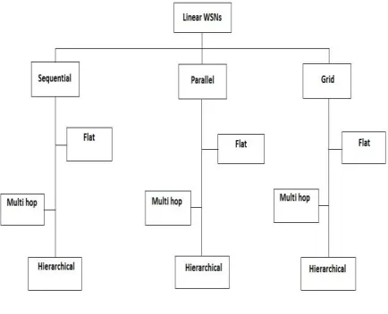
multi-hop and hierarchical LWSN architectures. Before discussing these categories, it is important to know that each LWSN must belong to one of the topological categories and one of the hierarchical categories. This depends on the nature of the application and its requirements. Figure 1 shows an overview of LWSN classification.
Fig. 1. Overview of LWSN types
distance. Figure 2 shows a linear sequential WSN in a pipeline with a flat architecture.
Fig. 2. Linear sequential WSN with flat architecture
Multi-hop LWSN Architecture: Sensor nodes send their data to the base station in multi-hop fashion. Each sensor sends the data to its neighbor, which then sends the data on to the base station. This type is efficient for medium-length LSNs, as it avoids the limitations of flat architecture. However, it takes a long time to reach the base station, especially in large networks, and it is difficult to maintain the network if there is a failure. A parallel LWSN in a railway track with multi-hop architecture is shown in Figure 3.
Fig. 3. Parallel LWSN with multi-hop architecture
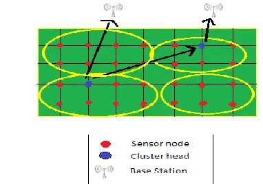
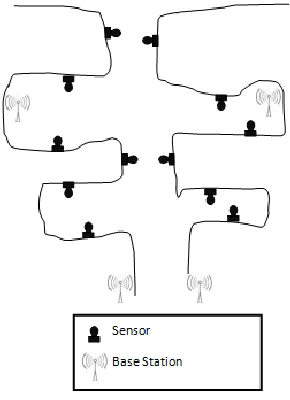
Hierarchical LWSN: This is where the sensor nodes are grouped in clusters and each cluster is managed by a cluster head. The cluster head receives messages from the cluster members and transmits the aggregated messages to the neighbor cluster head (in a multi-hop fashion) or directly to the base station. This architecture has lower latency than the previous type and the messages are transmitted through fewer hops. Figure 4 shows a grid LWSN in a paddy field with hierarchical architecture.
Fig. 4. A grid LWSN with hierarchical architecture
3 APPLICATIONS OF LINEAR WIRELESS
SENSOR NETOWRKS
This section explains in detail the potential applications of linear wireless sensor networks. In each application we discuss the importance of the application, the need or motivation for a real-time monitoring system, the traditional methods used in each application (and their limitations), the benefits of using LWSN as an alternative solution, a scenario using LWSN in the application (supported by figures), and finally give an example of a proposed or existing system using LWSN.
A. Railway Track Monitoring
damage to railway infrastructures (strain, deficiencies, inclinations and collapses) as well as huge economic losses in terms of commodities, lawsuits, liability issues and negative publicity. In addition, these threats may lead to dire consequences, such as loss of life, lengthy service disruptions, and damage to adjacent infrastructures. Recent real-world examples include an accident that happened in Poland. This was in March 2012 where two express trains collided head-on leaving 16 people dead and 58 injured because one of them was on the wrong track, as reported by the BBC.
Due to increasing threats, extreme dependability on railway infrastructure and the impact of their disruption, monitoring railway tracks is of utmost importance in order to ensure safety, security and reliability. However, real-time monitoring of railway tracks is extremely challenging due to the unavailability of communication infrastructure, the large geographic dispersion and diverse environmental conditions. Moreover, real-time train localization may also help in improving service safety and security.
One of the traditional ways of monitoring railways is patrolling. i.e., a small group (or individual) that is responsible for observing a specific length of railway for a specific duration. This has some limitations; for example, it may not be feasible to monitor railway tracks that are extended over thousands of miles, and real-time monitoring is not possible. Modern security systems are now used to protect railway infrastructures; these include some different sensing technologies combined with management systems. However, they still rely on human operators for supervision and intervention. Therefore, there is a need to improve the current monitoring systems to make them more persistent, reliable and efficient, and this can be achieved by using WSNs.
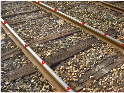
Thus, WSNs can be used to monitor railway tracks. Sensors are placed along the railway track in a parallel form as shown in Figure 5. These sensors are capable of collecting the data and sending them to the base station. The utilization of WSNs in railway monitoring provides a continuous observation for the whole railway track, whatever its length. Also, the cost of network deployment will be reduced because of the use of wireless communications and the low power and small size of the sensor nodes.
Fig. 5. Linear WSN on a railway
[6] proposed a system based on WSNs where the sensors are deployed along the railway track. Their purpose was to find new solutions and techniques in order to reduce the incidence of accidents and problems facing the railway operations. So, multi-homing and multi-path routing approaches are utilized in this proposal in order to improve reliability and reduce the energy spent on transferring data. Also, the authors proposed a technique to be utilized in the system called a fuzzy logic-based aggregation technique. The aim is to increase the amount of information that can be read from the sensors.
SENSORAIL [7] is an architectural proposal of an early warning system based on WSNs for railway infrastructure monitoring. It is appropriate for two applications regarding rail transportation systems: structural health monitoring and environmental security monitoring applications. The purpose of SENSORAIL is to provide continuous and automated monitoring of the railway against threats and attacks. The authors mentioned that the system is under experimentation and they aim to integrate it with security management systems already developed by Ansaldo STS.
B. Urban Traffic Monitoring
2010. Traffic congestion causes a great deal of disruption, such as delays for people seeking to arrive on time for meetings, employment or reserved flights. Moreover, traffic congestion can result in economic losses as well as air pollution from vehicle emissions. Therefore, monitoring urban traffic is crucial in avoiding congestion as well as in making predictions about traffic flows.
Traffic state monitoring systems as they are currently applied are able to warn people and direct them to unblocked roads [8]. However, this operation is facilitated through video cameras, which require employees to watch the roads on monitors. This can be considered as a limitation as many employees are needed to watch the screens all the time. Moreover, in bad weather the video cameras cannot work well because of poor visibility.
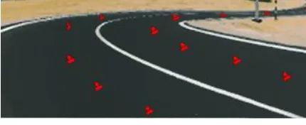
Clearly, utilizing WSNs in real-time traffic monitoring systems could solve many problems, including congestion, and could greatly assist in determining accident locations. Sensors can detect specific features (such as flow and speed) continuously and automatically by deploying them linearly along the road, as shown in Figure 6. This will assist the efforts of transport ministry employees through supporting monitoring at night and in bad weather (rain/snow or dust). This would be addition to the low cost of the network and ease of sensor deployment.
Fig. 6. Deploying nodes on the road
Most of the publications in this area deal with sensors to be deployed on vehicles, not on the road [9, 10]. Deploying sensors on the road helps to determine traffic flow of the road. So, in [8] the authors have proposed two methods to be implemented with the sensor nodes in order to apply WSNs in Intelligent Transportation Systems (ITS) for real-time traffic monitoring. They assumed that a road is equipped with sensor nodes deployed along its length and that one base station collects the road data from the nodes and then displays the traffic status information. The first method they use is an adaptive segmentation (AS) of traffic flow that provides responses in an appropriate time to any traffic status changes (with acceptable error margins). This produces adequate
data to guide the drivers to avoid congestions and choose an alternative route. The second method is an algorithm for in-network aggregation (INA) of the traffic flow. The aim of this algorithm is to limit the energy consumed by minimizing the communication between the sensors. These methods have been experimented on real data from PeMS, presenting good levels of efficiency.
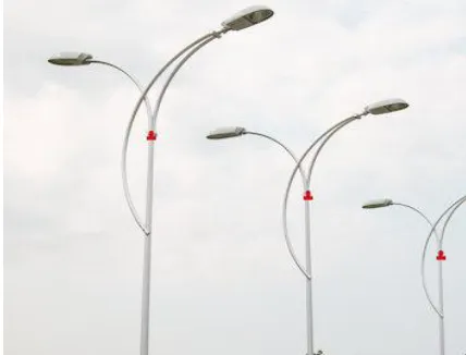
C. Streetlight Monitoring
Street lighting depends heavily on the urban scheme, lighting devices and their positions. People since ancient times have recognized the importance of streetlights as a safety factor and an impediment to crime. Lighting was applied in the streets centuries ago where people hung lanterns on their doors and carried them whilst wandering at night. After that, electric lights were used until the advent of high-intensity discharge lamps. Now, with the development of the automotive industry and the increasing traffic on the roads, street lighting has gained a new importance, utilizing intense glow lamps in order to illuminate the city’s streets during the dark hours. Streetlights can be used also to decorate streets as well as reduce accidents and crime. However, they are exposed to various problems that disrupt their main functions, such as electricity blackouts; sometimes, they just burn out. Therefore, it is important to apply a monitoring system to guarantee that the street lighting is functioning normally.
Earlier, streetlights were switched on at sunrise and switched off at sunset manually, which involves much human labor. Then, they applied a smart controller, which switches the street lights on and off automatically by setting the lights to sunrise and sunset, or sensing the light intensity surrounding the controller [11]. Nevertheless, this needs employees to patrol the streets in order to monitor their status and reduce errors such as setting the wrong time in the controller, which would lead to lighting the streets in daytime and dimming them in the evening. Furthermore, streetlights may be covered with dust or snow, making then unable to sense the light intensity, resulting in the same problems. These issues cost a great deal in maintenance and management. Now, the most widely used system is remote street lighting monitoring and control [12], which consists of:
Remote terminal units (RTUs): Each power substation has an RTU to control and monitor the remote sites.
Radio and general packet radio service (GPRS): This is used for communication between the control center and each RTU.
However, this system is unable to monitor and control each lamp individually; it only controls the street lighting through each power substation, although there are some new technologies with the goal of monitoring and controlling individual lamps, such as Power Line Carrier (PLC) [13]. The disadvantage of this technology is communication failure caused by noise and carrier signal attenuation.
It is clear that wireless sensor networks can help in monitoring and controlling streetlights by deploying sensors on each lamp, as shown in Figure 7. This will reduce power consumption and the status of each lamp will be immediately available. Also, it will lower management and maintenance costs, and increase the availability of street lighting. The authors in [14] proved this; they proposed a remote streetlight monitoring and control system based on a WSN that consists of the same components as described above in addition to wireless sensor nodes (deployed on each lamp pole). All sensors and RTUs are displayed on a map so the user can determine the precise location of any faulty lamp or RTU in order to repair it. This occurs when the sensor node detects a change in the lamp status and sends a message to the control center via an RTU.
Fig. 7. LWSN on streetlights
D. Bridge Monitoring
A bridge is a structure that links two otherwise remote locations, separated by obstacles such as a body of water, a river or a valley. Humans have constructed bridges since antiquity. Bridges are of great importance in linking isolated areas, establishing railways in areas hampered by waterways or mountainous terrain, and in carrying and transmitting power cables, fresh water pipes and oil and gas pipelines. For example, Sydney Harbour Bridge, with a total length 1,149m, carries a railway, motor vehicles, pedestrians and cyclists; it links the Central Business District with the North Shore.
Bridge infrastructures are exposed to several threats; these can be earthquakes, storms, terrorist attacks or lack of maintenance, all of which can cause damage or even collapse of the infrastructure of the bridge. In November 2011, the Kutat Kartauegara Bridge (suspension bridge) in Indonesia collapsed leaving 20 people dead, 44 injured and 33 missing. This accident happened while workers were repairing a cable; it is under investigation. Such accidents show that it is very important to develop safety monitoring systems to evaluate the health status of bridges and to avoid damage and accidents during construction and use.
Traditionally, bridges were evaluated by workers who observed bridges periodically, which was expensive. Several wired monitoring systems have since been developed; however, these systems suffer from several drawbacks, such as high cost, difficult installation and inadequate design. Also, the main disadvantage of wired systems is that they require a supply power and interconnections between the components of the system, which obstructs the utilization of its services [15].
Fig. 8. Monitoring bridges using LWSN
E. Border Monitoring
Today, border security is an important issue in all countries. The task becomes more difficult in long borders and especially in regions with low populations and difficult access. Monitoring the USA-Mexican border, which is 3,169km long is particularly difficult; it is the most frequently crossed international border in the world, with 350,000,000(check this!!) crossing yearly, costing tens of millions of dollars per year, using a large number of fences and barriers with a great many border patrol agents [16, 17].
Conventional border patrol system consists of security checkpoints and border troops. The checkpoints are erected on international roads to check the vehicles and occupants that cross the border, while the border troops monitor specific sections of the border according to predetermined schedules [18]. This traditional method for border monitoring costs a great deal in time and effort on the part of the border patrol, especially on long borders or in harsh environments; for example, the Canada-USA border is the longest international border in the world at 8,891km long. By using the traditional method, it is too difficult to continuously monitor all the border areas.
There are many threats to international borders, such as the illegal smuggling of goods, illegal immigration, drug dealers and terrorists. These threats can occur in different ways, either on foot, in vehicular traffic, by tunneling, through gunfire or by using light aircraft [19]. To face these threats in real time and with minimum human intervention, different technologies have been proposed. For example, OptaSense is a system that uses simple fiber optic communication cables and sensors to detect a variety of border threats instead of using fences and barriers. It depends on a wire stretched along the border, but any damage or cut in the wire will have effects over long distances. Also, the cost
of a wired deployment is high, and therefore this method is not practical [19]. Another example is Unmanned Aerial Vehicles (UAVs), which using aerial surveillance to detect and track illegal border crossing. However, adverse weather conditions can compromise it functionality and it is highly expensive. Also, UAVs cannot cover the whole border. Sometimes, surveillance towers with video monitors are used, and they can provide high accuracy in human detection. However, they usually need human interaction to determine the type of intrusion [18]. WSNs can be used to address the limitations of the existing monitoring techniques. They have the benefits of continuous monitoring and can cover the whole border region with minimal human support; this will save the border patrol’s time and effort. Also, WSNs can help making monitoring in harsh environments and in bad weather more accurate and easier.
In border monitoring, the network should cover a large area and because the sensor radius is limited, we need a large number of sensors. Different kinds of sensors can be used such as underground, above ground, camera and mobile sensors [18]. Figure 9 shows how sensors can be deployed underground or above ground in the border area.
Fig. 9. Underground and above ground sensors deployed in a border area
Last, mobile sensor nodes are deployed to move throughout the border area, either on land or in the air. The researchers have proposed the network architecture, the sensor deployment strategy, the detection strategy, the tracking algorithm and the communication protocols. The future work of this work is to simulate and test the proposed system [18].
F. Pipeline Monitoring
Nowadays, the need of energy resources has increased all over the world; the economies of many countries now depend on their gas and oil industries. Also, consumers depend on gas and oil, either for heating or as a transportation fuel. Therefore, keeping energy resources available continually is essential. Resources are transferred from producer to industry or to another consumer country using pipelines [20, 21]. Long pipelines are used to transfer natural gas or oil; for example, there are around 500,000 miles of oil and gas pipelines in the USA that extend to Canada and Mexico [21]. Also, one of the longest pipelines is the Langeled Pipeline that extends for 1,200km from the Ormen Lange field in Norway to the Easington Gas Terminal in England; this pipeline supplies 20% of the gas demand in England [22]. Such pipelines are used as a transportation system, pumping crude oil or gas from underground wells in an oil or gas field to storage a point, a processing facility, a shipping terminal, refineries and ultimately consumers [20].
Moreover, pipelines are used to transfer and distribute water inside cities and from its various sources to industries. Gulf countries depend on water desalination as the main source for potable water; for example, the city of Riyadh in Saudi Arabia is completely dependent on water transfer through a 3,800km long pipeline from the Shuoiba Desalination Plant at Al Jubaul on the Arabian Gulf [23]. Also, in dry summers, southern Australia depends heavily on water flowing down the Murray River; yearly, the Murray River supplies about 40% of South Australia’s needs, but this increase to 90% in dry summers. Water from the Murray River is supplied around the State through five major pipelines [24]. Based on the importance of transportation pipelines for gas, oil and water, they need to be kept safe from damage or leakage using monitoring systems. This is essential for the economy and security of many countries.
However, these pipelines are under threat from many different factors. Some of these factors are intentional threats, such as illegal tapping; one company in South East Asia is losing US$ 4 million worth of oil every year due to illegal
tapping from underwater pipelines. Also, pipelines can be damaged deliberately by terrorists; for example, in 2002, there were 900 attacks on the Cano Limon oil pipeline in Colombia, causing the loss of about 2.5 million barrels of crude oil. In Iraq, this is one of the main security problems [22]. These attacks not only cause economic problems, but also sometimes result in human casualties and even death.
On the other hand, sometimes pipeline threats emanate from non-intentional or natural factors, such as high temperatures, hurricane winds, earthquakes and tsunami. Also, pipelines can fail for physical structural reasons, such as high pressure. Human error in maintenance can cause a pipeline stop pumping. Also, threats may be from train or car accidents if the pipeline is above ground, or from shipping accidents if it is underwater. For preventive and predictive maintenance operations, we need pipeline monitoring systems for the continuous surveillance of pipelines in order to protect them from damage and to decrease the risk associated with transporting hazardous and potentially dangerous materials like natural gas.
Pipelines can be lain on the ground, underground or underwater. The position of a pipeline is determined by the material to be pumped, the geology and topology, the climatic conditions and the distance between the source and the destination. Each type of pipeline has particular needs and requirements as well as special advantages and limitations.
Above-ground pipelines:
A significant advantage of above-ground pipelines is that they can simply be placed directly on the surface. In the USA, above-ground piping is used at about 750 gas processing plants and 3,000 compression stations [25]. This is also a good choice for temporary piping systems. Another feature is ease of examination and maintenance [26]. However, above-ground pipelines are more open to threats and inclement weather including very high or very low temperatures.
Underground pipelines:
Underwater pipelines:
Using underwater pipelines to transfer oil and gas has certain challenges. The modeling of nodes must take into account environment factors such as temperature and water clarity as these can affect the quality of the signal transmissions. Also, the nodes have limited power, and their batteries cannot be charged with ease as solar energy cannot be exploited. Moreover, the sensors are exposed to failure by many factors such as fouling and corrosion [28]. Under the Arabian Gulf and between Qatar and the UAE, there are pipelines about 464km long that transfer a high percentage of UAE’s gas needs [22].
Pipeline monitoring systems can be classified (based on the position of the sensors) into two categories: inside the pipeline and outside the pipeline. Internal sensors can be used to measure the internal pressure, temperature and flow rate, while external sensors can be used to monitor the area outside, such as detecting fire and locating leaks [23, 27].
Monitoring techniques using internal sensors include [27]:
- Acoustic sensors: these are suitable only for detecting small leakages in pipelines and they are insensitive to large leaks.
- Transient-based methods: these use pressure sensors to determine the size and location of the leakage but the sensors can be deployed only in a limited number of locations within pipelines; this decreases the accuracy of this technique.
- Mass balance methods: these use flow sensors to monitor the flow differences inside the pipeline in order to detect leakages. However, this method can give false detections because a change in the flow can be caused by a variety of innocuous reasons, not necessarily leakage. Also, this method is unable to localize the position of a leak.
Monitoring techniques for external sensors [27]:
- Visual inspection: this utilizes video or image sensors to monitor the area around the pipeline. The sensors have large sensing ranges and can detect any abnormal status. However, this method cannot be used with underground pipelines.
- Ground penetrating radar (GPR): this is used to detect leakage in underground pipelines without the need for digging. However, it is not a real-time technique, meaning that leaks cannot be detected as they occur.
- Soil propriety sensors: these are suitable for underground pipelines. Different types of sensors are used depending on the fluid being transported. For example, humidity sensors can be used to detect water leakage, and hydrocarbon vapor sensors can be used in natural gas pipelines.
Fig. 10. Sensors deployed inside and outside the pipeline
MISE-PIPE is a proposed underground pipeline monitoring system based on wireless sensor networks. The purpose of MISE-PIPE is to detect and localize leakages in underground pipelines by utilizing internal and external sensors as well as pressure sensors, soil property sensors and acoustic sensors. It provides accurate real-time leakage detection and localization [27].
G. Underground Mine Monitoring
The mining industry is one of the pillars of the global economy. Many countries consider mining to be an important economic resource, such as the USA, Canada, Australia, South Africa, China and India. The global annual income from mining is over $70 billion [31]; the materials extracted include gold, copper, iron, cobalt and coal. The world today cannot dispense with mineral products, not only to produce power or to heat homes, but also to fuel the expansion of computers and modern technology. Due to the importance of the mining industry, monitoring systems should be used inside mines to ensure their continuous and safe operation. Safety is fundamental to mining; for example, the Sunjiawan mine disaster, which occurred in China in 2005, was caused by a gas explosion that resulted in the death of 214 coal miners.
To avoid the risk of any such disasters, a reliable real-time monitoring system should be established [32, 33]. Such a system is able to detect the air temperature, pressure, humidity, wind speed, and poisonous and flammable gases; gas leaks are one of the main causes of disasters in underground mines [32, 34, 35]. Also, the system can be used to track miners and vehicles to identify the exact location of all workers in real time [32]. The current underground mine monitoring systems mostly use wired sensor networks. However, they are difficult to extend should the mining zone be expanded, and installation and maintenance can be expensive, particularly in the typically harsh
environment of a mine. Moreover, cables are susceptible to ageing and wear, and are prone to failure [36]. WSNs have the potential to handle these problems effectively. The sensors in WSNs can be deployed easily by placing them in the desired locations. Also, the reliability of the system is increased; if one sensor fails, the entire system will continue to work normally.
The sensors are deployed along the mine in specific locations in a linear fashion, working together as an effective tool for gathering data in order to determine the characteristics of the environment or to detect a risky event; these data are then transferred to the surface station [36, 37]. Figure 11 shows how sensors can be deployed in a mine.
Fig. 11. Sensors deployed in a mine
RESTful Web is a proposed Web service coal mine safety monitoring and control system using WSNs to collect data on the underground conditions, such as on temperature, humidity and methane as well as on the exact location of each emplyee. An Application Programming Interface (API) is implemented on the sensors to provide access to those sensors and make them easily combined with other enterprise information resources [33].
H. Tunnel Monitoring
important types of tunnel is the mining tunnel, which is used in the extraction of raw minerals.
Given the global rise in population and the presence of natural obstacles such as mountains, rivers and seas, which obstruct the construction of transportation infrastructure, tunnels are increasingly needed; they are used to overcome obstacles both between and within urban centers. Tunnel construction has increased in recent years, to improve current transportation infrastructures and to reduce highway distances. The longest tunnel in the world is the Thirlmere Aqueduct in the UK at 154km long, while longest undersea rail tunnel is the Seikan Tunnel in Japan at 23.3km long. These long tunnels need continuous monitoring systems to monitor ground conditions, underground water levels and nearby structures. Sometimes, another monitoring system is deployed depending on the objective of the tunnel, i.e. whether it is part of highway or railway, or whether it is used to transfer water or sewerage.
Building tunnels costs a great deal but they are expected to last for decades or even centuries; for example, the London Underground is over 100 years old [38]. Throughout their lives, these structures need timely maintenance and continuous monitoring to prevent accidents or collapses. Traditionally, early maintenance is done by visual inspection where maintenance workers are sent out to conduct periodic inspections. This is not a real-time technique; when a problem occurs, it is not detected directly. Also, it is expensive in terms of time and effort. An alternative to human monitoring is to use wired a sensor network, which would provide real-time monitoring, but it would cost a considerable sum to install as it is difficult, especially in a long tunnel, to wire sensors together [38]. The utilization of WSNs to monitor tunnels benefits from the flexible deployment of sensors and from dispensing with wires. This will reduce the cost of deployment and make the maintenance operation easier and cheaper. Moreover, WSNs enable simple expansion of the system if needed [38].
WSNs are deployed with sequential topology along the tunnel and are powered by battery. The data collected by sensors are transmitted through a multi-hop protocol to access the base stations, which are usually located at the ends of the tunnel, which in turn send the data to the ground monitoring center [39].
WSNs for tunnels monitoring are still in the research prototype phase, and currently there are no practical deployment scenarios [38]. On the London Underground, in the Jubilee Line tunnel, an experiment was conducted 26 nodes that were
deployed along 180 meters to measure changes in temperature, displacement, humidity and inclination. This WSN was built to gauge the efficiency of the COTS WSN hardware, which is used in infrastructure monitoring.
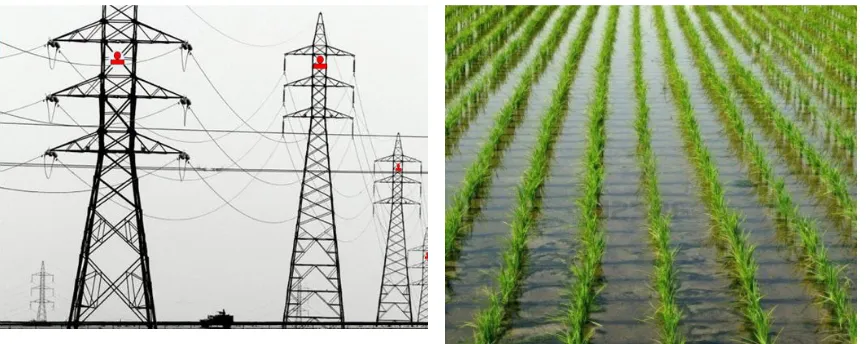
I. Electricity Transmission Line Monitoring
The purpose of overhead transmission lines is to transfer electrical power from the power plant, through the distribution system and sub-stations, to industrial and domestic consumers. Transmission lines carry high voltage current and are suspended by towers; they supply the electrical energy to large areas, while low voltage transmission lines (often via underground cables) supply smaller areas, carrying the energy to the consumer. These high voltage transmission lines are susceptible to failure and fires caused by short circuiting; this is for several reasons. The first is that the insulators can fail, allowing the cables to touch each other. Also, the cables can swing and droop in bad weather, again allowing the cables to touch each other. The last and most important cause is encroachment on the lines by vegetation or animals violating the line; this is particularly so on low voltage domestic supply lines. These problems may disrupt the transmission and distribution of electricity, and may cause blackouts, resulting in economic loss for the electricity company. For example, there was a blackout in the USA in 2003 that resulted in a $100-billion economic loss. Therefore, it is necessary to monitor these lines continuously.
Fig. 12. Sensor nodes on transmission poles
J. Crop Monitoring
Precision Agriculture (PA) is a concept relating to farm management that benefits from new technology such as GPS, GIS, satellite and wireless communication in order to optimize the returns whilst maintaining scarce resources [41].
Row planting is a system of growing crops in a linear pattern, as opposed to broadcast planting. There are many advantages to row planting over broadcast planting. First, light absorption is increased and this results in more efficient photosynthesis and improved crop yields. Second, it enhances the passage of wind along the rows, which increases gas exchange and prevents too much humidity. Third, it facilitates access, which in turn facilitates farm operations such as weeding. Finally, it enhances the visibility of the plants, making plant inspection easier. Because of these advantages, many crops, such as rice, coconut, oil palm, rubber, corn and peanut, are planted using this pattern [42]. By applying PA on row planting, it is possible to increase crop production while reducing the cost of cultivation. The farmer can monitor the soil condition, temperature, humidity, water level, plant moisture, mineral content and insect injury, weed growth and disease [41, 43-45]. All of these parameters are monitored to create a high-quality environment and to enable the farmer take different decisions to achieve higher yields, saving natural resources and reducing the overall cost. For example, an automatic remotely controlled system was established in an irrigated area in Spain, saving 30-60% in water usage [45]. Figure 13 shows a paddy field with a row pattern.
Fig. 13. Paddy field with row pattern
Using human labor to monitor farms is impractical and is practically impossible in large areas. Applying a technology such as wired sensor networks is also not practical in agriculture, as the cables would be inordinately long and would be costly as well as taking too much time and effort. Satellite monitoring has been used in agriculture through applying passive and active sensors and by providing images of large areas, but this technique has a time resolution of more than 10 days [41].
Alternatively WSNs can be used in agriculture in three different ways. First, in crop management, WSNs are used to monitor plants in real time and to provide an information base for farmers to detect and monitor disease development. For example, a timer is used to assess leaf wetness to detect the possibility of septoria, sending the data in real time to the farmer or to decision makers. Temperature, humidity, wind speed, light and moisture are all factors that affect the successful growing of plants. In addition, WSNs can be used to measure the density of the leaves, which determines the growing stage of the crop; this will help the farmer predict when the crop could be harvested. Second, WSNs are used in irrigation management; sensors are used to take the decision as to when it is appropriate to initiate irrigation. This not only reduces water use, but also avoids over-irrigation, which results in nutrient imbalances in the soil. Last, sensors can be used to monitor the environment around the plant, such as rain intensity or air pollution, which are critical aspects in planting and growing. WSNs have the advantage of easy and large-scale deployment, self-organization, low cost and the ability to network with other sensor systems and exchange data with external users [44, 46, 47].
maintain the crop’s desired environmental conditions [48]. As shown in Figures 14 and 15, the sensors are deployed in a linear form in the field, attached on columns or fitted underground. The sensors measure the required parameters and transmit the data to the base stations or the relay nodes, and then to the PC to be processed and saved.
Fig. 14. Sensors attached to an irrigation sprinkler
Fig. 15. Sensors deployed in linear form in a greenhouse
An example of a monitoring system for agriculture using WSN is proposed for monitoring the water level in paddy fields in India. By automating the water monitoring using wireless sensors, labor costs are decreased and rice production should increase [43, 46].
K. Monitoring Sports Activities
The world of sport is continually changing and over the years using technology has made a considerable impact. Technology is now applied in many different fields within sport. It can assist umpires and referees in doing their job more accurately, and it is now employed in goal-line monitoring in football, in ‘hawk-eye’ technology (which tracks the ball in cricket and tennis), in monitoring the physiological data of players, and in various other applications [49]. We will focus on those applications that are best suited to linear structures, which are: monitoring physiological data or tracking the movement of players in a square or rectangular court, as well as those that can deal with parallel linear infrastructures and hawk-eye technology.
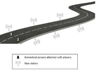
Physiological data are very important to athletes, for determining their fitness level, maximizing their performance and avoiding injury. Also, these data are very important for coaches, through which they can identify the physiological status of their athletes and can make changes during matches or in their training plans [50]. These physiological data include heart rate, temperature, ECG and oxygen level [51, 52]. At present, monitoring athletes’ physiological data depends on wired connections; this is time consuming, need much effort and is not real-time monitoring because the athlete must stop training. WSNs can be applied as an alternative to wired monitoring for obtaining physiological data; however, reports on WSN in physiological data monitoring are rare [50]. WSN affords real-time monitoring using biomedical sensor nodes that are attached to the player to sense and send data to the base stations that are installed along the boundary, as Figure 16 shows, or along the sides of racing tracks, as shown in Figure 17 [53].
Fig. 17. Biomedical sensors attached onto runners and base stations along the race track
WSNs provide real-time monitoring with easily deployed sensors, requiring less work from the coaches. Logbooks are commonly used by players and coaches to monitor progressive changes in training. However, this method is not practical and takes time and effort on the part of the coaches. Also, some important information may be missed. The alternative is to use video to record the training sessions or matches but this needs human labor to analyze the video, process the data and record important information [54, 55]. WSNs can be used to track the players’ motion inside the court area or within the racing lines. Motion data sensors are used to collect kinematic data such as speed, rate of turn or acceleration [52]. These sensors are usually wearable devices, and the base stations are deployed along the boundary or the sides of the race track. This real-time tracking is of benefit to coaches, umpires and referees, and assists in speedy decision-making.
In tennis, an electronic line judge device was used from the 1970s, which automatically detected whether the ball had landed within the boundaries of the playing zone. In 2000, the sport began to use video cameras to allow for a review of recent play when required on high visibility televisions. Using WSN, sensors can be deployed along the lines to detect whether or not the ball has landed ‘in’ or ‘out’.
An example of WSN for monitoring the physiological data of athletes was applied in an experiment in a basketball court at Zhejing University in China. The system monitored the temperature and pulse of the players. The experiments showed that the system was stable and reliable [50].
4 OPEN RESEACH ISSUES AND
CHALLENGES
In order to meet the present day monitoring requirements for LWSNs, such as increasing the performance of traditional monitoring systems and benefiting from WSN features, certain design requirements need to be considered and more research issues should be investigated, especially as so few research papers have discussed the special requirements for LWSN. These issues have consequences for network performance but they can be determined based on application requirements and objectives. Therefore, they should be kept in mind when designing LWSN.
The design issues presented in this paper are: choosing suitable surveillance devices, optimal deployment of sensors, choosing battery type and energy harvesting, selecting communication protocols, and increasing the network’s reliability.
Choosing suitable surveillance devices
The surveillance device is the major part of a wireless network, as network operations depend on it. The surveillance device is a sensor node that collects data from the surrounding environment. There are many types of sensors, and each has its own unique features, performing differently in different conditions. When applying WSN, a suitable sensor type should be chosen such that it is applicable to the information to be collected, such as physiological data, temperature, pressure, moisture, vibration, etc. Moreover, the sensing range for the sensor should be taken into account. The sensing range of the different types varies based on the environment, the design, and the event that is to be detected. Sensing ranges can differ from 5m to 15m. Another factor that should be considered when choosing the sensor type is the power requirement, as each type has a different power requirement [56]. Also, the nodes can be static or mobile. The advantages of mobile nodes over static ones are better energy efficiency, improved coverage and enhanced target tracking.
Sometimes, a single type of sensor cannot capture all the needed data, and therefore more than one type may need to be used.
Micro-electro-mechanical systems (MEMS) now allow for
sensors, optical sensors, ultrasound sensors, thermal sensors, chemical sensors, magnetic sensors and others.
Optimal deployment of sensors
In LWSN, sensor deployment needs to be studied carefully because it influences many aspects, such as the reliability and cost of the network. Some sections of the application may need more sensors than others due to the need for more intensive monitoring, which means we may need to cluster the sensors in certain sections. Also, researchers have found that large distances between sensors means that more power is needed for communication [56]. However, deploying the sensors close to each other increases the network cost. Thus, more research is needed to study the most efficacious distance between sensors, i.e. one that will achieve a good balance between the different factors.
Choosing battery type and energy harvesting technology
WSNs typically use batteries as the power supply for the sensors. The different battery types have different lifetimes, from very short (e.g. zinc-air cells) to very long (e.g. lithium thionyl chloride cells, which can work for up to 20 years). Also, some batteries are rechargeable (e.g. lithium ion), while others are not (e.g. alkaline) [56]. Therefore, the battery type to be used should be chosen based on the application requirements. Battery life is the basic limitation in WSN. Hence, researchers should focus on studying this limitation and find some solutions to it. One of the technologies used is energy harvesting, which entails collecting energy from surrounding sources. Many forms of energy harvesting have been discussed in different researches, such as solar energy, vibration-based energy, thermal energy, magnetic energy and radio frequency energy [56]. Different resources have different attributes and the optimal technology selected is based on the application needs.
Choosing communication protocol
Media access control (MAC) protocols are
responsible for providing reliable communication channels for sensors with the minimal power consumption. Different schemas have been used by researchers to achieve battery conservation, and each schema is based on a different mechanism designed to save the power of the sensors. The predominant MAC protocols are the Random Access (RA) schema, which uses a power-on/power-off mechanism, and Time Division
Multiple Access (TDMA), which is a variation of the RA schema; it achieves power efficiency by allowing the sensors to enter an inactive state based on time-slot scheduling. There are many others schemas, such as TEEM, PAMAS and S-MAC, which are based on a listen/sleep mechanism [56]. For special types of LWSN (e.g. underwater and underground), finding a suitable protocol is a big challenge.
Increasing network reliability
To provide high-level reliability, WSN employs high-density sensor deployment in order to provide multiple alternative paths; this will increase the network’s reliability. However, it may increase the overall cost of the network and sometimes lead to decreased network capacity because of interference effects [56]. Therefore, determining the optimum sensor density is very important.
Another factor that affects network reliability is the transport mechanism, which ensures that the quality of the data transferred within the network is reliable. The different transportation mechanisms have their own advantages and limitations, and the most suitable mechanism should be the one that best meets the requirements of the application.
Another open research area is to study the possibility of integrating LWSN with other technologies (such as satellite, radio frequency identification (RFID) or cellular networks) to facilitate transferring the collected data to some distant location or to assist in transmitting the data between two different parts of the system, where each part uses a particular type of communication. The difficulties and special needs vis-à-vis integration mean that the type of protocol most suitable for transferring data between the various parts must be considered. The economic benefits and other advantages of this procedure could be considerable.
5 CONCLUSION
architectures based on the requirements of the given application. Then, a detailed description of each potential application was given, supported by figures, to illustrate the idea of using LWSN in the application. We found that regardless of the purpose of the system, WSN enhances the objectives of the project by decreasing the time and cost of network deployment and maintenance, by increasing its reliability, by enabling a large number of nodes to be included in the network, and by making the monitoring process effective and safe. We also explained some important design issues that should be considered when deploying LWSN in different applications. These issues can be considered as an open research area that could be studied in the future. We believe that this survey will help in designing application-specific architectures, models and protocols; this will help in increasing the efficiency of linear wireless sensor network.
6 REFERENCES
[1] J. Yick, B. Mukherjee and D. Ghosal, "Wireless sensor network survey," Comput. Netw., vol. 52, pp. 2292-2330, 2008.
[2] I. F. Akyildiz, W. Su, Y. Sankarasubramaniam and E. Cayirci, "Wireless sensor networks: a survey," Computer Networks, vol. 38, pp. 393-422, 2002.
[3] S. Alahakoon, D. M. G. Preethichandra and E. M. I. Mala Ekanayake, "Sensor Network Applications in Structures – A Survey," Electronic Journal for structural engineering - international, 2009.
[4] I. Jawhar, N. Mohamed and D. P. Agrawal, "Linear wireless sensor networks: Classification and applications," J. Netw. Comput. Appl., vol. 34, pp. 1671-1682, 2011. [5] W. Zhengjie, Z. Xiaoguang and Q. Xu, "The
application and issuse of linear wireless sensor networks," in System Science, Engineering Design and Manufacturing Informatization (ICSEM), 2011 International Conference, 2011, pp. 9-12.
[6] E. Aboelela, W. Edberg, C. Papakonstantinou and V. Vokkarane, "Wireless sensor network based model for secure railway operations," in
Performance, Computing, and
Communications Conference, 2006. IPCCC 2006. 25th IEEE International, 2006, pp. 6 pp.-628.
[7] F. Flammini, A. Gaglione, F. Ottello, A. Pappalardo, C. Pragliola and A. Tedesco, "Towards Wireless Sensor Networks for railway infrastructure monitoring," in
Electrical Systems for Aircraft, Railway and Ship Propulsion (ESARS), 2010, 2010, pp. 1-6. [8] M. Shuai, K. Xie, X. Ma and G. Song, An
On-Road Wireless Sensor Network Approach for Urban Traffic State Monitoring. New York: IEEE, 2008.
[9] H. Sawant, T. Jindong and Y. Qingyan, "A sensor networked approach for intelligent transportation systems," in Intelligent Robots and Systems, 2004. (IROS 2004). Proceedings. 2004 IEEE/RSJ International Conference on, 2004, pp. 1796-1801 vol.2.
[10]Y. Ding, C. Wang and L. Xiao, "A static-node assisted adaptive routing protocol in vehicular networks," presented at the Proceedings of the fourth ACM international workshop on Vehicular ad hoc networks, Montreal, Quebec, Canada, 2007.
[11]G. M. Robinson, "Smart photoelectric control senses lighting problems" Design News, vol. 51, p. 99, April 1995.
[12]C. Iordache, S. Gavat, C. Mada, D. Stanciu and C. Holban, "Streetlight monitoring and control system Part I: System structure," in Automation, Quality and Testing, Robotics, 2008. AQTR 2008. IEEE International Conference on, 2008, pp. 183-186.
[13]C. SungKwan and V. Dhingra, "Street lighting control based on LonWorks power line
communication," in Power Line
Communications and Its Applications, 2008. ISPLC 2008. IEEE International Symposium on, 2008, pp. 396-398.
[14]J. Chunguo, S. Dongmei and G. Deying, "Design of Streetlight Monitoring and Control System Based on Wireless Sensor Networks," in Industrial Electronics and Applications, 2007. ICIEA 2007. 2nd IEEE Conference on, 2007, pp. 57-62.
[15]T. Harms, S. Sedigh and F. Bastianini, "Structural Health Monitoring of Bridges Using Wireless Sensor Networks," Instrumentation & Measurement Magazine, IEEE, vol. 13, pp. 14-18, 2010.
[16]A. Mishra, K. Sudan and H. Soliman, "Detecting border intrusion using wireless sensor network and artificial neural network," in Distributed Computing in Sensor Systems Workshops (DCOSSW), 2010 6th IEEE International Conference on, 2010, pp. 1-6. [17]A. S. Tanenbaum, C. Gamage and B. Crispo,
"Taking sensor networks from the lab to the jungle," Computer, vol. 39, pp. 98-100, Aug 2006.
"BorderSense: Border patrol through advanced wireless sensor networks," Ad Hoc Networks, vol. 9, pp. 468-77, May 2011.
[19]A. Owen, G. Duckworth and J. Worsley, "OptaSense: Fibre Optic Distributed Acoustic Sensing for Border Monitoring," in Intelligence and Security Informatics Conference (EISIC), 2012 European, 2012, pp. 362-364.
[20]N. Mohamed, I. Jawhar and K. Shuaib, Reliability Challenges and Enhancement Approaches for Pipeline Sensor and Actor Networks: CSREA Press, 2008.
[21]N. Mohamed and I. Jawhar, "A Fault Tolerant Wired/Wireless Sensor Network Architecture for Monitoring Pipeline Infrastructures," in Sensor Technologies and Applications, 2008. SENSORCOMM '08. Second International Conference on, 2008, pp. 179-184.
[22]N. Mohamed, I. Jawhar, J. Al-Jaroodi and L. Zhang, "Sensor Network Architectures for Monitoring Underwater Pipelines," Sensors, vol. 11, pp. 10738-10764, 2011.
[23]I. Jawhar, N. Mohamed and K. Shuaib, "A framework for pipeline infrastructure monitoring using wireless sensor networks," in Wireless Telecommunications Symposium, 2007. WTS 2007, 2007, pp. 1-7.
[24](2012, 20 October). Pipelines Available: http://www.sawater.com.au/sawater/education/ ourwatersystems/pipelines.htm
[25]M. R. Akhondi, A. Talevski, S. Carlsen and S. Petersen, "Applications of Wireless Sensor Networks in the Oil, Gas and Resources Industries," in Advanced Information Networking and Applications (AINA), 2010 24th IEEE International Conference on, 2010, pp. 941-948.
[26](12 October). Above Ground Facilities and
Structures. Available:
http://www.pipelineattorney.com/services/abov e-ground-facilities.html
[27]S. Zhi, W. Pu, M. C. Vuran, M. A. Al-Rodhaan, A. M. Al-Dhelaan and I. F. Akyildiz, "MISE-PIPE: Magnetic induction-based wireless sensor networks for underground pipeline monitoring," Ad Hoc Networks, vol. 9, pp. 218-27, May 2011.
[28](20 October). Underwater Acoustic Sensor
Networks (UW-ASN). Available:
http://www.ece.gatech.edu/research/labs/bwn/ UWASN/
[29]K. Jong-Hoon, G. Sharma, N. Boudriga and S. S. Iyengar, "SPAMMS: A sensor-based pipeline autonomous monitoring and maintenance system," in Communication Systems and Networks (COMSNETS), 2010
Second International Conference on, 2010, pp. 1-10.
[30]I. Jawhar, N. Mohamed, M. M. Mohamed and J. Aziz, "A routing protocol and addressing scheme for oil, gas, and water pipeline monitoring using wireless sensor networks," in Wireless and Optical Communications Networks, 2008. WOCN '08. 5th IFIP International Conference on, 2008, pp. 1-5. [31](2012, 20 October). Different Countries
Greatly Depend on Mining. Available: http://designsbydel.com/2012/02/countries-greatly-depend-mining/
[32]T. Maity, P. s. Das and M. Mukherjee, "Rescue and protection system for underground mine workers based on Zigbee," International Journal of Advanced Computer Engineering & Architecture, vol. 2, pp. 101-106, 2012. [33]B. Cheng, X. Qiao, B. Wu, X. Wu, R. Shi and
J. Chen, "RESTful Web Service Mashup Based Coal Mine Safety Monitoring and Control Automation with Wireless Sensor Network," in Web Services (ICWS), 2012 IEEE 19th International Conference on, 2012, pp. 620-622.
[34]W. Quan-fu, Z. Shen, Y. Yuan and T. Liang, "The application of wireless sensor networks in coal mine," in Information, Communications and Signal Processing, 2009. ICICS 2009. 7th International Conference on, 2009, pp. 1-4. [35]W. Shi and L.-l. Li, "Multi-parameter
monitoring system for coal mine based on wireless sensor network technology," in Industrial Mechatronics and Automation, 2009. ICIMA 2009. International Conference on, 2009, pp. 225-227.
[36]L.-m. Yu, A. Li, Z. Sun and H. Li, "Design of Monitoring System for Coal Mine Safety Based on Wireless Sensor Network," in Mechtronic and Embedded Systems and Applications, 2008. MESA 2008. IEEE/ASME International Conference on, 2008, pp. 409-414.
[37]N. Chaamwe, L. Wenyu and J. Hongbo, "Seismic monitoring in underground mines: A case of mufulira mine in Zambia: Using wireless sensor networks for seismic monitoring," in Electronics and Information Engineering (ICEIE), 2010 International Conference On, 2010, pp. V1-310-V1-314. [38]F. Stajano, N. Hoult, I. Wassell, P. Bennett, C.
[39]J. Haifeng, P. Jiansheng and P. Wei, "Nonuniform clustering routing protocol for tunnel wireless sensor network in underground mine," in Wireless Communications & Signal Processing, 2009. WCSP 2009. International Conference on, 2009, pp. 1-5.
[40]J. Ahmad, A. S. Malik, L. Xia and N. Ashikin, "Vegetation encroachment monitoring for transmission lines right-of-ways: A survey," Electric Power Systems Research.
[41]J. C. Giacomin and F. H. Vasconcelos, "Wireless Sensor Network as a Measurement Tool in Precision Agriculture," XVIII IMEKO WORLD CONGRESS - Metrology for a Sustainable Development, pp. 17-22, 2006. [42]B. G. Bareja. (April 2011, 20 October). What
Is and How Crops are Arranged in Row
Planting. Available:
http://www.cropsreview.com/row-planting.html
[43]S. Simon and K. P. Jacob, "Preliminary Design on the Development of Wireless Sensor Network for Water Table Monitoring in Paddy Fields," International Journal of Distributed and Parallel Systems, vol. 2, pp. 87-93, 2011. [44]I. F. Akyildiz and E. P. Stuntebeck, "Wireless
underground sensor networks: Research challenges," Ad Hoc Networks, vol. 4, pp. 669-686, 2006.
[45]W. Ning, Z. Naiqian and W. Maohua, "Wireless sensors in agriculture and food industry - Recent development and future perspective," Computers and Electronics in Agriculture, vol. 50, pp. 1-14, Jan. 2006. [46]S. Simon and K. P. Jacob, "Wireless Sensor
Networks for Paddy Field Crop Monitoring Application in Kuttanad," International Journal of Modern Engineering Research (IJMER), vol. 2, pp. 2017-2020, 2012.
[47]L. Ruiz-Garcia, L. Lunadei, P. Barreiro and I. Robla, "A Review of Wireless Sensor Technologies and Applications in Agriculture and Food Industry: State of the Art and Current Trends," Sensors, vol. 9, pp. 4728-4750, 2009. [48]D. D. Chaudhary, S. P. Nayse and L. M.
Waghmare, "Application of Wireless Sensor Networks for Greenhouse Parameter Control in Precision Agriculture," International Journal of Wireless & Mobile Networks (IJWMN), vol. 3, pp. 140-149, 2011.
[49](20 October). Technology in Sports Available: http://www.topendsports.com/resources/techno logy.htm
[50][50] Y. Xie, F.-q. Wu, and L.-g. Li, "An intelligent wireless sensor network applied research on dynamic physiological data
monitoring of athletes," pp. 71301F-71301F, 2008.
[51]V. Sivaraman, S. Grover, A. Kurusingal, A. Dhamdhere and A. Burdett, "Experimental study of mobility in the soccer field with application to real-time athlete monitoring," in Wireless and Mobile Computing, Networking and Communications (WiMob), 2010 IEEE 6th International Conference on, 2010, pp. 337-345.
[52]P. Wilhelm, E. Monier, F. Xu and U. Witkowski, Analysis of Indoor Team Sports Using Video Tracking and Wireless Sensor Network. Germany, 2008.
[53]D. Benferhat, F. Guidec and P. Quinton, "Disruption-tolerant wireless biomedical monitoring for marathon runners: A feasibility study," in Wireless Personal Multimedia
Communications (WPMC), 2011 14th
International Symposium on, 2011, pp. 1-5. [54]J. Pansiot, A. Elsaify, B. Lo and Y.
Guang-Zhong, "RACKET: Real-time autonomous computation of kinematic elements in tennis," in Computer Vision Workshops (ICCV Workshops), 2009 IEEE 12th International Conference on, 2009, pp. 773-779.
[55]V. Braysy, J. Hurme, H. Teppo, T. Korpela and M. Karjalainen, "Movement tracking of sports team players with wireless sensor network," in Ubiquitous Positioning Indoor Navigation and Location Based Service (UPINLBS), 2010, 2010, pp. 1-8.