Copyright © 2014 CTTS.IN, All right reserved
Geomorphological Mapping of Remote Area
Using RS & GIS Technology of Doda Catchment
(Zaskar Basin, Jammu Kashmir)
Shashikant
JRF, Haryana Space Applications Centre (HARSAC),[email protected]
Pallavi Singh
Student, University of Rajasthan
R. D. Doi
Professor, University of Rajasthan- Jaipur
Abstract – Doda catchment area had remained almost unknown for decades because of the inaccessibility and political restrictions. In the present study, geomorphological mapping using remote sensing techniques have been carried out in Doda catchment of Zaskar Basin (Jammu & Kashmir). Uses of remote sensing and GIS techniques have been proned indispensable in geomorphological study. In the present investigation an attempt is being made to use the NRIS (Natural Resource Information System) standard for geomorphic mapping. Likewise, delineation of study area is based on Watershad atlas of India (1990). Denudational hill is predominating in the study area covering 41 percent of its geographical area. Structural hills are second predominating features of the study area, which cover 24 per cent area of its geographical extant. The other geomorphic features mapped glaciers, valley, ridges, braided bar, point bar, river terrace, exposed rock and lateral moraine etc which cover 35 per cent of Doda catchment. Landsat ETM+ imagery is suitable for geomorphic features identification on the scale on 1:50,000. The Landsat satellite data is used to identify and delineate the extent of the de-glaciated valley features dimensions of the valley and the type of moraines. The most dominating elevation range in the study area between 4500 to 6000 meters. Mostly geomorphic features are dominated in the 050 to 300 slope class.
Keywords - Geomorphological mapping, Satellite data Remote Sensing & GIS.
1. INTRODUCTION
Geomorphology is the science that investigates how landforms are formed on the Earth. The study of the landforms evolution and development is debatable issue today in remote areas with limited field-based glaciological measurements. Geomorphological map is very effective tools in management of natural resource and help in various types of planning and development
activities. Geomorphological mapping allows an improved understanding of Watershad management, ground water exploration, and land use planning. Remote sensing technology has been found
useful in generating geomorphological map, because of the diverse and inaccessible terrain condition. [1]
Remotely sensed data has unique advantage over conventional data collection techniques in the study of geomorphology, as physiographical and geo-structural parameters are mostly discernible on the imagery. [2] Geomorphology-Landform is a three-dimensional feature on the earth surface formed by natural processes. Typically landforms include volcanoes, plateaus, folded mountain ranges, streams etc. Geomorphology is the science that studies the nature and history of landforms and deposition that created them.
It is important to note that judicious selection of spectral band is critical in mapping the glacier feature. The study carried out that in the visible band of Landsat TM the highly reflecting surface of snow glaciers reach saturation limits and are not useful in discrimination snow types and landforms in this area. [3]. Remote sensing data or Geographical Information System (GIS) and Global Positioning System (GPS) techniques have capability to provide reliable information for Geomorphological studies both qualitatively and quantitatively. The present study aims to analysis the different geomorphological features of remote are doda catchment of Zaskar Basin (Jammu & Kashmir).
2. STUDY AREA
The study area of Doda Catchments is situated in northwest part of the Zaskar Basin, (Jammu & Kashmir), India is located between 33°15‟N to 33°57‟ N latitude and76°25‟E to76°57‟ E longitudes. The total geographical area under study is 2023.95sq.km.
Copyright © 2014 CTTS.IN, All right reserved (HHCS). The area has well developed drainage system. In
this area the main river is Zaskar. The Zaskar River has two main tributaries – Doda and Tsarap. Doda (also known as Stod) originates from Dhrang-Dhrung glacier at the eastern flank of Pensi-La (4400m.) mountain-pass and then flows South-East along the main valley leading towards Padum. [4] Doda catchment is a high altitude, resulting in a pleasantly Warm and dry climate in summer.
Most of the precipitation occur as snowfalls during the harsh and extremely long lasting winter period. These winter snow falls are of vital importance since they feed the glaciers which will melt in the summer and provide most of the irrigation water. [5]
Figure: 1
3. MATERIALS AND METHODOLOGY
Geocoded National Aeronautics & Space Administration (NASA) (Landsat ETM+) Satellite Data of 28 October 2002, on the scale 1:50,000 are used to identifying the landforms of the Region. The lineaments on the Satellite image were identified on the basic of tonal change in geomorphological feature.
Table-1Satellite data specification
Band Name Band Width Spatial
Resolution
1 Blue 0.45-0.5 30m
2 Green 0.5-0.6 30m
3 Red 063-0.69 30m
4 Near Infra. 0.7-0.9 30m
5 IR-1 1.55-1.75 30m
6 Thermal IR 10.4-12.5 60m
7 IR-2 2.09-2.35 30m
8 Panchrom. 0.52-0.9 15m
Survey of India Topographical Sheets: on 1:50000 are also used as base data numbered as:
52C/05, 52C/06, 52C/09, 52C/10, 52C/11, 52C/14, 52C/15.
Software used:
ERDAS IMAGINE 9.3, ARC/MAP.9.2, Microsoft Office 2007and handheld Garmin 72 GPS.
The present Geomorphological maps were prepared on 1:50,000 scale to monitor the geomorphic features of study area during the year 2002. Geocoded National Aeronautics & Space Administration (NASA) acquired satellite data (Landsat ETM+) for the above years was used.
Figure: 2 Methodology flow chart
Geomorphological classification suggested by National Resource Information System (NRIS) was used for the study, shown in table no.2.
Table-2: Coding system for geomorphological mapping
Geomorphic class Features
Structural Origin
a. Cuesta b. Hogback c. Strike Rides d. Moderately Hills
Valley a. Gorge
b. valley
Depositional slope
a. Scree Deposits
b. Colluvial Fan
Fluvial Origin
a. Braided bar b. Channel Bar c. Point Bar d. Terraces
Glacial Origin
a. Arete b. Crique c. Horn
d. Terminal Moraine e. Lateral Moraine f. Medial Moraine g. Hanging Valley h. Moraine Dammed Lakes i. Supra glacial Lake
Fluvial a. River
b. Major Streams
Input Data
ETM+ image 2002
BND of AOI Georefernced
Projecting Features
Interpretation Statistics
Overlay Layers
Copyright © 2014 CTTS.IN, All right reserved
GROUND TRUTH:
Doubtful areas were checked by field verification and Locations of geomorphological features were also collected by handheld GPS.
4. R
ESULTS ANDD
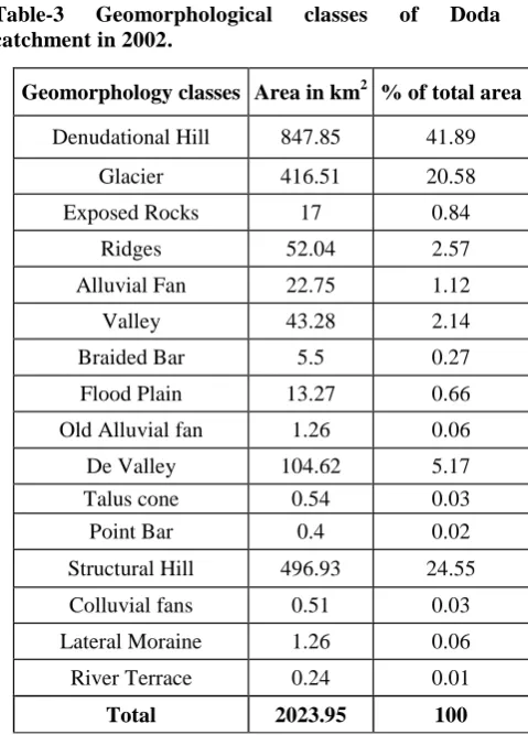
ISCUSSIONDenudational Hill is predominating features in the study area. It covers 847.8 km2areain 2002. Table no.3 shows different classes of geomorphic features during 2002 in the study area. The major geomorphic features of the study area in 2002 were delineate during the Landsat ETM+ Image interpretation as given under-
Denudational Hill is predominating features in the study area covering 41 percent of the study area. These hills are mostly concentrated in southern part of the study area as displayed in the Figure 3. Denudational hill cover 847.8 m2 area of Doda catchment. These features occur between elevations ranges of 1200 to 3000 meters. The hills deals with the slope range of 250 to 600.
The structural hills has cover 496.9 km2 sharing 24 per cent study area of Doda catchment as indicated in the Figure 3. These hills are mostly concentrated northern part of the study area. These features occur between elevations ranges of 1800 to 2400 meters. The hills deals with the slope range of 300 to 600.
Glacier A glacier is a large mass of ice formed by compaction and re-crystallization of snow, moving slowly by creep down slope, due to the stress of its own weight, and surviving from year to year. The glaciers in the Doda catchment are mainly of the Mountain and valley glacier type. The glacier features in the study area covering the 20 percent of study area. There were 127 small and large glaciers in the whole Doda catchment covering 416.5 km2 area of study area. Dhrang Dhrung is the largest glacier of Doda catchment covering 50 km2.Glacier Features as seen on Landsat ETM+ FCC (2002). All glaciers are Geocoded as GL1 to GL127. Glaciers covered the maximum southern part of the domain. Larger glaciers also found in that area. A field photo& satellite image of glacier valley is displayed in Photo Plate-1.
De-glaciated valley The valley and associated features are significant to determine the health of the glacier. The de-glaciated valley features in the study area covering 5.17 percent of its total geographical area. The valley is mostly concentrated in middle part of the study area as indicated in the figure 3. De-glaciated valley covers 104.6 sq kmarea of Doda catchment. De-glaciated deals with the slope range of 050 to 100. Mainly the de-glaciated valley and associated features that are mapped include the glacial valley, moraines like the terminal, medial, lateral moraine, outwash plain, moraine dammed lake, etc. A field photo of De-glaciated valley in the photo plate-1 from Doda catchment.
Valley is a lowland area between higher lands like mountains. The valley features in the study area cover 2.14 per cent of its geographical area as displayed in the figure 3. The valley features cover 43.28 km2 of Doda
catchment. These features occur between elevations ranges of 600 to 1200 meters. The valley deals with the slope range of 100 to 150.
Flood PlainDoda River is only one melt water body in the study area. The flood plain outwash features cover 13.26 km2 of Doda catchment. The flood plain features in the study area cover a little part 0.6 percent of its total geographical extant. The flood plain coinside with the slope range of 100 to 150.
Alluvial Fan Doda catchment has well developed drainage system area. Mostly the alluvial fan is found in the eastern part of the area. Alluvial fan covers 22.74 km2 area of Doda catchment. Alluvial fans coinside with the slope range of 050 to 100.
Table-3 Geomorphological classes of Doda catchment in 2002.
River terraces are the remains of old valley floors that are left sitting on valley sides after river down cutting. River Terrace is a roughly flat area that is limited by sloping surfaces on the upslope and down slope sides. River trace covers the 0.24 km2 area of the Doda catchment. The features coincide with the slope range of 050 to 100.
Lateral moraine is debris shoved together or melted out from the advancing glacier along its sides. The Lateral moraine covers 1.26 km2 sharing 0.06 per cent geographical area of Doda catchment.
Geomorphology classes Area in km2 % of total area
Denudational Hill 847.85 41.89
Glacier 416.51 20.58
Exposed Rocks 17 0.84
Ridges 52.04 2.57
Alluvial Fan 22.75 1.12
Valley 43.28 2.14
Braided Bar 5.5 0.27
Flood Plain 13.27 0.66
Old Alluvial fan 1.26 0.06
De Valley 104.62 5.17
Talus cone 0.54 0.03 Point Bar 0.4 0.02
Structural Hill 496.93 24.55
Colluvial fans 0.51 0.03
Lateral Moraine 1.26 0.06
River Terrace 0.24 0.01
Copyright © 2014 CTTS.IN, All right reserved
Photo Plate-1
De-glaciated valley
Dhrang Dhrung Glacier
Lateral moraine
River Terrace
Figure: 3 Geomorphology Map
C
ONCLUSIONSThe present study is conducted for geomorphological mapping using Landsat ETM+ satellite data for Doda catchment (Zaskar-Basin, Jammu & Kashmir) on 1:50000 scale. Total Geomorphological area under study area is 2023.95 sq km in 2002. The conclusions are as.
Denudational hill is predominating in the study area covering 41 percent of its geographical area. Structural hills are second predominating features of the study area, which cover 24 per cent area of its geographical extant.
At several places, impressive sets of river terraces have been located. Padam is the largest U-shape valley part of Doda catchment. The glacier features in the study area covering the 20 percent of its geographical area. There are 127 small and large glaciers in the whole Doda catchment covering 416.5 km2 area of its geographical area.
Dhrang Dhrung is the largest glacier of Doda catchment covering 50 km2area.
Copyright © 2014 CTTS.IN, All right reserved are U-shaped valleys, truncated spurs with
shorn-off faces, arêtes, horns, pyramidal and conical peaks, serrated crests of ridges, cirques, arêtes, glacial troughs, smooth rock walls, steep head walls and rock steps in the longitudinal profiles at the junction of tributaries.
It was observed that Landsat +ETM satellite data proved to be very useful in the interpretation of different geomorphic classes and their mapping. Global Positioning System (GPS) easily provide location information of these classes.
The Geomorphological maps are useful to the planner for the further development in the study area.
R
EFERENCES[1] Shibani maitra 1999. Landforms and geomorphological classification part of the upper Baittarani river Basin. PP.175-184.Photonirvachak, Journal of the ISRS vol. 27, no.3.
[2] Agarwal, C.S. et al 1996. Role of remote sensing in demarcation of alluvial fan deposits in Tarai-Bhabar belt of Nainital district (U.P.) and the environmental impact assessment.
Photonirvachak, Journal of the ISRS vol. 24, no.1, p.53
[3] COOKE,R.U.& DOORNKAMP J.C. 1990. Geomorphology in Environmental Management, Oxford Press.
[4] O s m a s t o n , H.1994. The geology, geomorphology and Quaternary history of Zaskar, Himalayan Buddhist villages: Bristol, University of Bristol, p. 1–36.
[5] www.moef.nic.in/downloads/public-information /Snow-Glacier.pdf; ministry of environment and forest; govt. of India.
AUTHOR’S PROFILE:-
Shashikant
Junior Research Fellow