JOURNAL
of
THE GEOLOGICAL SOCIETY OF INDIA
Vol. 19 October 1978
CONTENTS
No. 10
REVIEW PAPER
Archaean Geology investigations in Southern India
RESEARCH PAPERS
PACF
C. S. Pu hamuthu 431
Radium content of some river-waters of India
S. D. Chatterjee and Partha Banerji 440
Exploration planning for Sandur Manganese Ores R N. Mishra 446
Theralite- Melteigite-Carbonatite association in Mer Ring of Mundwara Suite, Sirohi District, Rajasthan
Manas K. Chakraborti and Mthir K Bose 454
Petrology and geochemistry of a recently discovered mckeliferous serpcntirute
in Sn Lanka C. B. Dissanayake and B.J. Van RIel 4( 4
Acanthocerasfrom the Upper Cretaceous rocks of South India
G. W. Chip/onkar and V. G. Phansa/kar 472
A comment on the paper: An estimation of temperatures of Intrusion of Indian carbonatites using calcite-dolomite geothermometry, by S. F. Sethna and S. G. Viladkar, Jour. Geo/. Soc India, v 18, pp. 275-280
by J Gttuns 477
OBITUARY
N. A. Vemban (1921-1978)
B. Vasudeva Murthy (1917-1978)
ANNUAL SUBSCRIPTION
4BI
4R2
JOURNAL OF THE GEOLOGICAL SOCIETY OF INDIA VOL.19,No. 10, OCT. 1978,pp.431to439
ARCHAEAN GEOLOGY INVESTIGATIONS IN SOUTHERN INDIA
C. S. PICHAMUTHU Abstract
A brief review is made of the investigations conducted on the Archaean rocks of southern India from the time of Newbold (1838) to the present. Problems connected with Dharwar stratigraphy and the relationship of Peninsular Gneiss to Dharwar schists and charnockites have given rise to considerable differences of opinion and the main features of these controversies are summarised. Much of the confusion is due to the fact that terms like' Dharwar' and 'Peninsular Gneiss' have been used in very different senses by individual workers. Geochemical and geochronological investigations are of recent origin and have yielded some interesting results. An account is given at the end of some of the problems in Precambrian geology that are still awaiting solution in southern India.
INTRODUCTION
Research on the Archaean rocks of southern India commenced with the work of Newbold who, in a series of papers published between 1838 and 1844, described the geology of some regions which fall within the present-day boundary of the State of Karnataka. He was the first to separate the schists from the gneisses and record instances of intrusion of gneisses into schists. Foote (1886, 1888, 1895) coined the term'Dharwar System' to designate all crystalline schists (of volcano-sedimentary origin) as opposed to felsic gneisses, and considered the Dharwar as younger. HoI-land (1900, 1902, 1909) was, however, of the opinion that all the Dharwar rocks were not younger than the Archaean gneisses. Almost all the early geologists (Hatch, 1902; Walker, 1902; Maclaren, 1906; Middlemiss, 1917; Jones, 1922; Heron, 1935; Crookshank, 1948) found the gneisses intruding the schists; but explained it away as due to local re-fusion, or plastic deformation and penetration, because at that time it was believed that the crust of the earth was granitic in composition, and that the schists had a sialic basement.
DHARWAR SCHIST-PENINSULAR GNEISS RELATIONSHIP
In the former princely State of Mysore (now Karnataka), the geologists of the Survey headed by Smeeth (1901, 1916) and Sampat Iyengar (1920), found numerous evidences of gneissic intrusion into schists and, therefore, considered the Dharwar formations as older, a view that was accepted by Fermor (1909, 1936), Rama Rao (I936a), and Pascoe (1950). More recently some have expressed a diametrically opposite view that the gneisses nowhere intrude the schists, and that they are all older, and form a basement to the schists (Nautiyal, 1966; Radhakrishna, 1967; Swaminathet al., 1974). There has, however, been a gradual withdrawal from this extreme position, and it is now conceded that the gneisses intrude the high grade schists but form a basement to the younger schist belts (Radhakrishna, 1974; Swaminathet al., 1976), that the Kolar belt has suffered a subsequent thermal event (Ramakrishnanet al., 1976), and that the mantled gneiss domes in the younger belts are 'rejuvenated basement' and not just' basement highs'.
NOMENCLATURE
432 C. S. PICHAMUTHU
Foote's Dharwar System into' Dharwar ' and' Pre-Dharwar ', Ifa sequence with a particular name is divided, separate names should be given to the parts; a name designating the whole sequence should not be used for a part of it (Hedberg, 1976). That is how confusion arose in charnockite nomenclature because Holland gave the same name 'charnockite' to the whole series as well as to its acid member. Some schists cannot, therefore, be 'Dharwar' and others' Pre-Dharwar' ; the sub-divisions should have distinct names. Even among those who are using these terms there is no agreement at present as to where Dharwar ends and Pre-Dharwar commences. The prevailing confusion has been aggravated by some geosynclines being called 'Dharwar type' (Ramakrishnan et al., 1976). Normally, Pre-Dharwar rocks should lie below the oldest schist formation (say, Sargur, if it is proved to be the oldest). But now, it is Sargur to some, Kolar and Hutti belts to others, and even Sandur belt to some others. ' Dharwar basement' has, therefore, many different meanings; this is a very unsatisfactory state of affairs.
It is necessary also to use the term 'Peninsular Gneiss', which was coined by Smeeth in 1916, in its original meaning. According to Smeeth, it is a complex of various granites that' give evidence of successive intrusion, and the fact that the earlier forms contain their own pegmatites which are truncated by subsequent forms, points to a long continued period of plutonic activity. Frequently, the various members mingle either by repeated injection or absorption or crushing and shearing, and we get zones or areas which are highly banded or with complex flow structure. Other portions are more homogeneous and appear as granite masses. Amongst these latter are some which may be definitely later in age than the gneiss as a whole' (Smeeth, 1916).
Terms like Dharwar and Peninsular Gneiss are fundamental in Indian geology; they have become international terms, and gone into the very fabric of Precambrian nomenclature. Great caution should, therefore, be taken before attempting to change their significance and scope.
Peninsular Gneiss is a migmatitic complex which probably includes basement and intrusive components. This implies that there could be pre- and post-Dharwar gneisses. Both Dharwar schists and Peninsular Gneisses cover a vast span of geo-logical time during which sedimentation and intrusion were taking place. Field and laboratory studies should be undertaken to identify these different episodes. Tonalite pebbles in the Dharwar Kaldurga conglomerates have given very old dates-3250± 150 m.y, (Venkatasubramanian and Narayanaswamy, 1974). Peninsular Gneisses are younger (2950-2600 m.y.), and are mainly granodioritic.
PRIMORDIAL CRUST
ARCHAEAN GEOLOGY OF SOUTHERN INDIA 433
STRATIGRAPHY
For some decades it has been known that the younger Dharwar chloritic schists prevail innorthern Karnataka, and the older hornblendic schists in the south as well as bordering some schist belts, especially the Chitradurga belt (M.G.D. geological map, 1915). It was then believed that both schists and gneisses were igneous in origin. The sedimentary origin for some Dharwar rocks was finally established only in 1935-1936 (Pichamuthu, 1935 a, b, c; Rama Rao, 1936 a, b). This was a major break-through in Archaean geology research in southern India.
In 1901, Smeeth suspected that the Kolar belt was older than the Shimoga and Chiknayakanhalli belts. In 1905, Sampat Iyengar classified the Chitradurga Schist Belt into three divisions based on unconformities. The first comprehensive classifi-cation of the Dharwar System was attempted by Rama Rao (1936 a) when he divided it into Lower (basic and acid flows and intrusives), Middle, and Upper, separated by unconformities. He considered that all of them were intruded by Peninsular Gneiss. Like Smeeth, he was of the opinion that the original basement was not recognisable.
The geosynclinal development of Dharwar was envisaged by Pichamuthu in 1946; he then postulated two cycles of sedimentation in the Shimoga and Chitaldrug belts each with its attendant igneous phenomena, and stated that the Dharwar sequence started with an igneous complex of basic volcanic flows and intrusives followed by sedimentary successions interrupted by batholiths and stocks of acid rocks.
In 1968, Srinivasan and Sreenivas recorded a geosynclinal history in the Chitra-durga belt starting with shelf passing through flysch, and finally to molasse facies of sedimentation. In 1972, they classified the Dharwar System into a four-fold division based on tectonomagmatic and atmospheric evolution.
In 1972, Naqvi and Hussain proposed two sequences in the Dharwar Supergroup, one older than 2600m.y.and another younger. Later, Naqviet al.(1974) considered the older as 'true greenstone belts' and the younger as ' geosynclinal piles'. Accord-ing to their latest thinkAccord-ing (Naqvi, 1976; Naqviet al.,1976) the Kolar, Holenarsipur, Nuggihalli, and Sargur schists are' true greenstone belts' (3500-3200 m.y.), and the Shimoga, Bababudan, and Chitradurga belts are' greenstone-like geosynclinal piles' (3000-2500 m.y.), Somewhat similar suggestions have also been made by Radha-krishna (1974), and RamaRadha-krishnanet al. (1976).
Till about 10 years ago all crystalline rocks in southern India were considered to be of Archaean age. Nautiyal (1966) was the first to suggest, without any supporting evidence, that the Dharwar schists were Proterozoic, and that the gneisses, amphibolites, and charnockites were Archaean. In 1972, Srinivasan and Sreenivas stated that the Dharwar rocks were Proterozoic and overlaid the Archaean charnoc-kites. According to Radhakrishna (1975), the Archaean greenstone belts are Nuggi-halli, Kolar, Ramagiri, and Hutti, whereas the Shimoga and Chitradurga belts are Proterozoic. Similar distinctions are made by Ramakrishnan et al. (1976) who consider that, apart from high-grade schists, there are two types of greenstone belts-one, Archaean (Sandur, Kolar, Hutti, Ramagiri), and another, Proterozoic (Baba-budan, Shimoga, Chitradurga).
These speculative exercises are still continuing, but cannot be conclusive unless backed by geochemical and geochronological data. Correlation should be based on
lithology and stratigraphy but there is very little evidence as yet of this type of detailed field work. In many of these classifications, the Chitradurga belt is
434 C. S. PICHAMUTHU
sidered to be Proterozoic, but this has been invaded by a granite which is at least 2535 m.y, old. The Kurubarmaradikere trap has given Rb-Sr ages of 3690 m.y. and 3205 m.y., and the Ingladhal trap 2595 m.y. (Crawford, 1969a). The galenas in this belt are 3000 m.y. old (Venkatasubramanian et al., 1977). It is now generally agreed that the age of 2500 m.y. limits the Proterozoic-Archaean boundary, and on this basis some of the traps in the Chitradurga belt are not Proterozoic but Archaean in age.
Since the term ' Dharwar' is now being used with several meanings, there are differences of opinion as to which is the lowermost member of the Dharwar Super-group. According to Foote (1895), in the Bellary district of Karnataka, it is in some places a trap flow, in others a micaceous quartzite, and in the Copper mountain ridge a bed of hematite quartzite. To some it is an orthoquartzite-carbonate bed (Srinivasan and Sreenivas, 1968), to others it is a current bedded quartzite, and to some others it is an oligomictic quartz-pebble conglomerate (Ramakrishnan et al., 1976). The occurrence of conglomerates, and instances of schists' resting' on gneiss, no doubt indicate unconformities, but not necessarily that they represent the very base of the Dharwar Supergroup (Pichamuthu, 1974). According to Naqvi (1976), the Holenarasipur-Nuggihalli belt is the oldest sequence in the Dharwar proto-continent, and that nowhere is there proof that it is underlain by a sialic crust.
Owing to a northerly tilt of the Dharwar craton, the older and more-meta-morphosed rocks occur in southern Karnataka as narrow belts, small strips, and islands, representing not only some of the formations exposed at deeper levels, but also older sequences. Except for slices of high-grade rocks at the borders of some schist belts, the main mass of rocks in Karnataka generally show a progressive increase in metamorphism from north to south (Rama Rao, 1936a; Pichamuthu, 1953; Radhakrishna, 1956; Narayanaswami, 1970). This prograde metamorphism in southern Karnataka has been confirmed by rhe-recent geochemical work of Anantl1a Iyer and Narayanan Kutty (1973, 1974, 1976) done on potash feldspars, garnets, and amphiboles.
The Dharwar craton is partly surrounded by the Eastern Ghats mobile belt formed penecontemporaneously with it and characterised by high-grade metamorphic rocks such as charnockites and khondalites. TheN-SDharwarian strike in southern Karnataka is deflected westwards by the ENE-WSWEastern Ghats trend, the disturbed
zone being marked by sheared gneisses and mylonites. There is no abrupt break between the lower grade schist-gneiss region and the high grade charnockites as suggested by Nautiyal (1966) and Iyengar (1976); the change from one to another is transitional (Pichamuthu, 1974). This granulitic belt is polymetamorphic and could represent reactivated segments of the basement.
In 1936, Rama Rao stated that the Sargur rocks resembled Fermor's Eastern Ghat facies, and raised the question whether they could not be the more intensely metamorphosed rocks of the Shimoga schist belt, or a zone of stilI older Dharwar rocks not found elsewhere in the Shimoga area.
ARCHAEAN GEOLOGY OF SOUTHERN INDIA 435
Some charnockites are products of regional thermal metamorphism of gneisses and schists (Pichamuthu, 1965). In southern Karnataka, charnockites are inter-bedded with runs of quartzites and banded ironstones. In Tamil Nadu, the associa-tion of pyroxene granulite-magnetite quartzite-pyritiferous quartzite in the granulite facies is considered to be the metamorphic equivalent of the basalt-ferruginous chert-sulphide association in greenstone belts; the Satyamangalam complex of schistose rocks exhibiting amphibolite facies grade of metamorphism has been correlated with the Wynaad complex of Kerala and the Sargur complex of Karnataka (N. G. K. Murthy, personal communication).
GEOCHEMISTRY
Early attempts at geochemical investigation were made by Karunakaran and Neelakantan (1947; 1948)in the Nellore district; by Howie (1955) and Subramaniam (1959, 1962, 1967) in the charnockite region of Tamil Nadu; and by Leelanandam (1967 a, b; 1969 a, b, c) in the Kondapalli area, Andhra Pradesh. More recently, Sisir Sen, Sobhen Ray and others in U.T., Kharagpur have been doing detailed geochemical work on minerals and rocks in the type area for charnockite near Madras (1970, 1971, 1974).
Since 1964, workers in the National Geophysical Research Institute, Hyderabad, have been continuously engaged in geochemical research on several fundamental problems in Archaean geology, such as the nature of the primordial crust, proto-continental growth, evolution of greenstone belts, recognition of proto-continental nuclei, etc. Viswanathan (1974, a, b; 1975) has introduced several modern geochemical concepts, and was responsible for the recognition of komatiites. Anantha Iyer and Kutty (1973, 1974, 1976) are actively engaged in the geochemical investigations of minerals in the Dharwar craton.
GEOCHRONOLOGY
Holmes (1955) was the first to date Indian rocks. Aswathanarayana (1956; 1962; 1964) did pioneering work in this field. Sarkar and his associates (1964; 1968) have contributed considerably in dating Indian rocks. Vinogradov and Tugarinov (1964); Crawford (1969 a, b), and Venkatasubramanian and his associates (1974, 1977), are responsible for a number of dates. The Geological Survey of India, the Atomic Minerals Division, and the National Geophysical Research Institute are prominent among the institutions actively engaged in geochemical and geochrono-logical investigations.
FUTURE WORK
In this brief account of Archaean geology investigations in southern India certain problems for further investigation have at appropriate places been pointed out. The tempo of research has appreciably quickened during the last 10 or 12 years giving rise to several questions still to be answered. Among the many problems awaiting solution, the following may be mentioned:
1) Correlation and reconciliation of several proposals made regarding Precam-brian stratigraphy;
2) Identification of the different episodes in Peninsular Gneiss and Charnockite formation;
3) Mineralisation episodes;
436 C. S. PICHAMUTHU
6) Distribution and nature of mafic and felsic dykes; 7) Relationship of charnockites and khondalites;
8) In Tamil Nadu, whether the gneisses and migmatites represent the Peninsular Gneisses of Karnataka, whether the granulites are metamorphosed green-stone belts, and if so, whether they have a recognisable basement. Basic work like geological and structural mapping should have priority. The major thrust will, however, have to be in the fields of geochemistry and geochrono-logy. Sophisticated instruments like mass spectrometer, electron microprobe, XRF, XRD, etc. are required, but these facilities are either negligible or absent at present. Itis very necessary that steps should be taken for the early setting up of at least one Central Laboratory equipped with advanced instruments necessary for this type of work which can be utilised by interested workers in government organisations and universities.
Geochemical and geochronological investigations would help in throwing light on some specific problems in the Archaean geology of southern India, such as: (1) Recognition of vestiges of the primordial crust; (2) Age and varieties of granites, gneisses, and charnockites ; (3) Age and nature of pebbles in Dharwar conglomerates; (4) Age and variety of xenoliths in granites and gneisses; and (5) Classification and composition of dykes.
References
ANANTHA IYER, G. V., (1973) The structural state of potash feldspars and regional metamor-phism in the Precambrian of southeast Mysore, Jour. Geol, Soc. India, v. 14, pp. 153-162.
ANANTHA IYER, G. V. and NARAYANAN KUTTY, T. R.,(1974) Geochemistry of garnets from the Precambrian of South Karnataka. Jour. Geol, Soc. India, v. 15, pp. 256-269.
- - (1976) Geochemistry of amphiboles from the Precambrian of Karnataka. Jour. Geol, Soc. India,v,17,pp, 17-36.
ASWATHANARAYANA,D.,(1956) Absolute ages of the Archaean orogenic cycles ofIndia. Amer. Jour. Sci.v,254, pp. 19-31.
- - (1962) Age of the Cuddapahs, India. Nature, v. 194, p. 566.
- - (1964) Isotopic ages from the Eastern Ghats and Cuddapahs of India. Jour. Geophvs, Res., v. 69, pp. 3479-3586.
CRAWFORD. A. R., (1969a) Reconnaissance Rb-Sr dating of the Precambrian rocks of southern Peninsular India. Jour. Geol. Soc. India, v.10,pp, 117-166.
- - (1969b) India, Ceylon, and Pakistan: new age data and comparisons with Australia.
Nature,v.223, pp. 380-384.
CROOKSHANK, H., (1948) Minerals of the Rajputana pegmatites, Trans. Min. Geol, Met. Inst.,
v.42.
DIVAKARA RAo, V., SATYANARAYANA. K., NAQVI, S. M. and HUSSAIN, S. M., (1975) Geo-chemistry of Dharwar ultramafics and the Archaean mantle. Lithos , v. 8, pp. 77-91.
FERMOR, L. L., (1909) Manganese ore deposits of India. Mem. Geol. Surv. India. v. 37, pp.
280-365.
- - (1936) An attempt at the correlation of the ancient schistose formations of Peninsular India. Mem. Geol. Surv. India, v. 70 (I), pp. 1-51.
FOOTE, R. B., (1886) Notes on the geology of parts of Bellary and Anantapur districts. Rec.Geol, Surv, India, v. 19 (2), pp. 98-99.
- - (1888) The Dharwar System, the chief auriferous rock series in South India. Rec. Geol. Surv, India, v, 21 (2), pp. 40-56.
- - (1895) Geology of Bellary District, Madras Presidency. Mem. Geol. Surv.Lndia, v. 25 (1),
pp. 1-218.
c.
S. PICHAMUTHU 437 HEDBERG, H., (1976) International stratigraphic guide. John Wiley&Sons, New York, pp. 1-260.HERON. A. M., (1935) Synopsis of the pre-Vindhyan geology of Rajputana. Trans. Natl. Sci. India, v, I. pp. 9-11.
HOLLAND, T. H., (1900) The Charnockite Series, a group of Archaean hypersthenic rocks in Peninsular India. Mem. Geol. Surv. Indla, v, 28. pp. 119-249.
(1902) Notes on rock specimens collected by Dr. F. H. Hatch on the Kolar Gold Field.
Mem. Geol, Surv, India, v. 33 (I), pp. 74-81.
(1909) Geology. Imperial Gazetteer0/India, v,1(2), pp. 50-103.
HOLMES, A., (1955) Dating the Precambrian of Peninsular India and Ceylon. Proc. Geol. Assn. Canada, v. 7, pp. 81-106.
HOWIE, R. A .. (1955) The geochemistry of the charnockite series of Madras, India. Trans. Roy. Soc. Edin., v. 62, pp. 725-768.
IYENGAR, S. V. P., (1976) The stratigraphy, structure and correlation of the Dharwar Supergroup.
Geol. Surv. India, Misc. Pub!., no. 23 (2), pp. 415-456.
JONES, H. C., (1922) The iron ores of Singhbhum and Orissa. Rec. Geol.Surv, India, v. 54. pp.
203-214.
KARUNAKARAN, C. and NEELAKANTAN, K., (1947) Samarskite from Nellore district. Part I. Uranium and earth acid contents. Proc. Indian Acad. Sci., v. 25 (A), pp. 404-407.
KARUNAKARAN, C. and NEELAKANTAN, K., (1948) Samarskite from Nellore district. PartII. Chemical composition. Proc, Indian Acad. Sci., v. 27(A), pp. 29-32.
LEELANAND<\M, C., (1967a) Distribution of titanium in co-existing pyroxenes from the Kondapalli charnockites. Current Science, v , 36, pp. 545-547.
- - (1967b) Chemical study of pyroxenes from the charnockitic rocks of Kondapalli (Andhra Pradesh), India, with emphasis on the distribution of elements in coexisting pyroxenes.
Miner. Mag.,v, 36, pp. 153-179.
(1969a) Electron microprobe analysis of chlorine in hornblendes and biotites from the charnockitic rocks of Kondapalli, A.P. Miner. Mag., v .37, pp. 362-365.
(I969b) Fluorine and chlorine in the charnockitic hornblendes from Kondapalli, A.P.
N. Jb. Miner. Mh.,v. 10, pp. 379-383.
- - (1969c) H20+, F, and CI in the charnockitic biotites from Kondapalli, A.P. N. Jb. Miner. Mh., v, 10, pp. 461-468.
MACLAREN, J. M., (1906) Notes on some auriferous tracts in southern India. Rec. Geol. Surv, India, v. 34, pp. 96-131.
MIDDLEMISS, C. S., (1917) Complexities of Archaean geology in India. Presidential Address, Section of Geology, Indian Sci. Cong.,J. Asiatic Soc. Bengal, v. 13, p. 195.
NAQVI, S. M., (1976) Physico-chemical conditions during the Archaean as indicated by Dharwar geochemistry. In The Early History of the Earth. Ed. B. F. Windley, pp. 289-298.
NAQVI, S. M., DIVAKARA RAo, V. and HARI NARAIN., (1974) The protocontinental growth of the Indian shield and the antiquity of its rift valleys. Precam. Res., v. 1,pp, 345-398.
- - - (1976) Primitive crust: evidence from the Indian shield. 25th Int. GeoI. Cong., Sydney. (Abstracts).
NAQVI, S. M., DIVAKARA RAo, V., SATYANARAYANA, K. and HUSSAIN, S. M., (974) Geo-chemistry of post-Dharwar basic dykes and the Precambrian crustal evolution of Penin-sular India. Geol. Mag., v. 111, pp. 229-236.
NAQVI, S. M. and HUSSAIN, S. M., (1972) Petrochemistry of early Precambrian metasediments from the central part of the Chitaldrug schist belt. Mysore, India. Chem. Geol., v. 10,
pp.l09-135.
- - (1973) Geochemistry of Dharwar metavoIcanics and composition of the primeval crust of Peninsular India. Geochim. Cosmochim. Acta, v. 37, pp. 159-164.
NARAYANA SWAMI, S., (1970) Tectonic setting and manifestation of the upper mantle in the Pre-cambrian rocks of south India. Proc, 2nd Symp. Upper Mantle Project. Hyderabad.
438 C. S. PICHAMUTHU
NEWBOLD, T. J.,(1838) Description of the valley of Sondur, Madras. Jour. Literary Soc .•v. 8, pp. 128-152.
- - (1841) Notes, principally geological, from the banks of the Tumbuddra to those of the Cauvery, Madras. Jour. Literary Soc., v. 11, pp. 126-143.
- - (1842a) Notes, principally geological, on the tract between Bijapur and Bellary. Jour. Asiatic Soc. Bengal.v. II.pp. 929-940.
- - (1842b) Notes, principally geological, from Bijapur to BellaryviaKannaghirri. Jour. Asiatic Soc. Bengal.v. 11,pp, 941-955.
- - (1844) Summary of the geology of southern India. Jour. Royal Asiatic Soc., v .8. PASCOE,E.,(1950) A manual of the geology of India and Burma. Third Edition, Calcutta,v .I,
pp. 1-483.
PICHAMUTHU, C. S., (l935a) The conglomerates and grits of Kaldurga, Kadur district,Mysore.
Proc. Indian Acad. Sci.,v. 2 (B), pp. 254-279.
- - - (1935b) The iron formations and associated rocks of the eastern Bababudans, Kadur disirict, Mysore. Half-Yearly Jour. Mysore Univ., v.8, pp. 1-48.
- - (1935c) The quartzites of the Bababudan area, Kadur district, Mysore. Current Science,
v. 4. pp. 179-181.
- - (1946) Cycles in Dharwar sedimentation. Current Science, v, IS,pp, 273-274.
- - (1947) Some aspects of Dharwar geology with special reference toMysore State. Presi-dential Address, Geo!.&Geog.Section. Proc.Tndian Sci. Congress.partII, pp, 1-16. - - (1953) Metamorphic facies inMysore State. Mysore Geologists' Assn. Infn. Circ.,v.47.
pp, 1-3.
- - (1965) Regional metamorphism and charnockitisation in Mysore State, India. Indian Mineralogist,v. 6,pp, 119-126.
- - (1974) The Dharwar craton. Jour. Geol. Soc. India, v,15, pp. 339-346.
- - (1976) Some problems pertaining to the Peninsular Gneiss Complex. Jour. Geol. Soc. India.v. 17, pp. 1-16.
RADHAKRISHNA, B. P., (1956) The Closepet Granite of Mysore State, India. Mysore Geologists' Assn. Spec. Publ.,pp. 1-110.
- - - (1967) Reconsideration of some problems in the Archaean Complex of Mysore, Jour, Geol. Soc. India,v. 8, pp. 102-109.
- - (1974) Peninsular gneissic complex of the Dharwar craton-a suggested model for its evolution. Jour. Geol. Soc. India. v, IS,pp. 439-454.
- - - (1975) The two greenstone groups in the Dharwar craton. Indian Mineralogist. v. 16, pp. 12-15.
RAMA RAO, B., (l936a) Recent investigations on the Archaean Complex of Mysore. Presidential Address, Geol.&Geog. Section,23rd Indian Sci. Congo Proc.•part 2, pp. 1-30.
- - - (1936b) Evidences for the sedimentary origin of some of the constituents of the Dharwar schists. Rec, Mys. Geol. Dept.,v. 34, pp. 22-31.
RAMAKRISHNAN, M., VISWANATHA, M. N. and SWAMINATH,J., (1976) Basement-cover relation-ships of Peninsular Gneiss with high grade schists and greenstone belts of southern Karnataka. Jour. Geol. Soc India,v. 17, pp. 97-111.
SAMPAT IYENGAR, P., (1905) Report on the survey work in the Chitaldrug district. Rec, Mys, Geol. Dept., V.6(2), pp. 57-92.
SAMPAT IYENGAR, P., (1920) The acid rocks of Mysore: a study in intrusion metamorphism and quantitative classification. Mys. Geol. Dept. Bull., v. 9. pp. 1-31.
SARKAR, S. N., (1968) Precambrian stratigraphy and geochronology of Peninsular India. Dhan-bad Publishers, pp. 1-33.
SARKAR, S. N., POLKANOV, A. A., GERLING, E. K. and CHUKROV, F. V., (1964) Geochrono-logy of the Precambrian of Peninsular India: a synopsis. Science & Culture, v. 30, pp. 527-537.
ARCHAEAN GEOLOGY OF SOUTHERN INDIA 439
SATYANARAYANA, K., NAQVI. S. M., DIVAKARA RAo, V. and HUSSAIN, S. M., (1974) Geo-chemistry of Archaean amphibolites from Karnataka State, Peninsular India. Chern. Geol., v,14. pp. 305-315.
SISIR SEN., (1974) A review of some geochemical characters of the type area (Pallavaram) charnockites. Jour. Geol, Soc. India, v. 15, pp, 413-420.
SISIR SEN and RAY, S., (1971) Hornblende-pyroxene granulites versus pyroxene granulites: a study from the type charnockite area. N. Jb. Miner. Abh., v, 115, pp. 291-314.
SISIR SEN and SAHU, J. R., (1970) Phase relations in three charnockites from Pallavaram-Tambaram. Contr. Miner. Petrol.• v, 27, pp. 239-243.
SMEETH, W. F., (1901) General report on the work of the Department for the years 1900 and 1901.
Rec, Mys. Geol. Dept., v. 3, pp. 1-46.
- - (1916) Outline of the geological history of Mysore. Dept. Mines and Geol. Mysore State. Bull., v. 6, pp. 1-21.
SOBHEN RAY., (1970) Significance of hornblende compositions from basic granulites of the type charnockite area near Madras. N. Jb. Miner. Mh., v . 10, pp. 456-466.
SRINIVASAN R. and SREENIVAS. B. L., (1968) Sedimentation and tectonics in Dharwar (Archaeans) of Mysore State. Indian Mineralogist, v. 9, pp. 47-58. .
- - - (1972) Dharwar stratigraphy. Jour. Geol. Soc. India, v. 13, pp. 75-85.
SUBRAMANIAM, A. P., (1959) Charnockites of the type area near Madras. Amer, Jour. Sci., v,257,pp. 321-353.
- - - (1962) Pyroxenes and garnets from charnockites and associated granulites. Geol. Soc. Amer. Buddington Volume. pp. 21-36.
- - (1967) Charnockites and granulites of southern India. Meddel. Dansk Geol. Foren.,
v. 17, pp. 473-493.
SWAMINATH, J. and 13 OTHERS, (1974) The cratonic greenstone belts of southern Karnataka and their possible relation to the charnockite mobile belt. Int. Seminar, Tectonics & Metal-logeny0/SE Asia&For East. Abstracts, pp. 38-39.
SWAMINATH, J., RAMAKRISHNAN, M. and VISWANATHA,M.N., (1976) Dharwar stratigraphic model and Karnataka craton evolution. Rec. Geol. Surv. india, v. 107, pp. 149-175.
VENKATASUBRAMANIAN, V. S., (1974) Geochronology of the Dharwar craton-a review. Jour. Geol. Soc. India, v.15,pp. 463-468.
VENKATASUBRAMANIAN, V. S. and NARAYANASWAMY, R., (1974) The age of some gneissic pebbles in Kaldurga conglomerate, Karnataka. Jour. Geol. Soc. India, v. 15, pp. 318-319.
VENKATASUBRAMANIAN, V. S., RADHAKRISHNA,B.P. and JAYARAM, S., (1977) Model galena ages for Karnataka and surrounding areas. Jour. Geol. Soc. India, v. 18, pp. 49-52.
VINOORADOV, A. and TUOARINOV,A., (1964) Geochronology of the Indian Precambrian. Rept,
22nd Int. Geol. Cong., New Delhi.
VISWANATHAN, S., (l974a) Contemporary trends in geochemical studies of early Precambrian greenstone-granite complexes. Jour. Geol. Soc. India, v. 15, pp. 347-379.
- - - (l974b) Basaltic komatiite occurrences in the Kolar Gold Field of India. Geol. Mag.,
v. Ill,pp. 353-354.
- - - (1975) Rocks of unusual chemistry in the charnockitic terrains of India, and their geo-logical significance. Geol, Mag., v, 112, pp. 63·69.
WALKER, T. L., (1902) The geology of Kalahandi State, Central Provinces. Mem. Geol, Surv; India, v. 33, pp. 1-22.
Address0/the author
JOURNAL OF THE GEOLOGICAL SOCIETY OF INDIA VOL. 19, No. 10,OCT.1978, pp. 440 to 445
RADIUM CONTENT OF SOME RIVER WATERS OF INDIA
S. D. CHATTERJEE AND PARTHA BANERJI
Abstract
The radium content of river waters collected from eighteen different Indian rivers has been measured. The river water can usually be classified into two categories: limpid and turbid. The radium content of limpid waters has been found to be lower (~10-I6gfml) than that of its turbid Partner (~10-15gfml). In the latter case, the radium contents both of the filtered component and the sediment have been separately measured. The sediment invariably exhibits a higher value.
INTRODUCTION
Thenatural racioacnviryor'warer rs derived primarily (rom (be radioactive rocks and minerals with which the water has been in contact. In certain areas, radioactive gases emitted from magmas may impart some radioactivity to natural waters emanat-ing from thermal spremanat-ings. Heretofore, very little information has been published in our country regarding the radium contents of normal surface and river waters. This is probably because the radium content of these waters is usually relatively small and there is no advertising incentive comparable to spring waters that are used at spas and health resorts. Moreover, the ra<:lioactivity of river water is subject to wide variation according to the character of' the gathering ground, the land over which the river flows, the discharges of its tributaries, sewages, industrial wastes, the season of the year and climatic conditions. The magnitude of the seasonal change will vary, of course, depending on the pqrticular stream of river in question. Accord-ingly, it is necessary to record the natural radioactivity of the running water of some selected rivers at suitable sites and to check the trend of its variation with time. A second important consideration is thllt the assessment of radium content of a river at selected sites along its route may fUfllish valuable information about geographical distribution and location of radioactive: minerals in the river valley. This has been typified in the case of the Ganges.
With the advent of the nuclear age, another important factor has become evident, viz., the selection of river sites for the installation of water-cooled reactors. As the river water flows through the reactor, certain elements present as dissolved salts become radioactive from the neutron bombardment, and other radio-isotopes present as corrosion products are washed frol:n the heat-exchange surfaces. The reactor effiuent thus contains a complex mixture of radio-isotopes, each contributing to the total activity. It should be noted, however, that the radio-isotopes present in the effiuent are emitters of f3 and "I-radiation only. The concentration of a -emitters, such as radium and uranium, below the plants, is not substantially different from that which occurs in the river stream. The various radio-isotopes discharged with reactor effiuent into the river accumulate in aquatic organisms. Itwould therefore be worth-while to make periodical ecological studies on the abundance of river organisms together with quantitative estimation of' radio-elements at suitable sites along the line of shore of particular rivers.
RADIUM CONTENT OF RIVER WATERS 441
EXPERIMENTAL METHOD
It is well-known that Ra226 the familiar radium isotope with a half-life of 1,620 years decays to the noble gas radon by a -emission.
Thus, 88Ra226 -';. 86Rn222. Radon itself is radioactive, decaying with a 3.82 days half-life by a -emission, Since radon can easily be isolated from the parent material and introduced directly into the ionisation chamber, the measurement of the radio-activity of radon gives a quantitative estimation of radium present in the mother material. This particular technique is well established and has been successfully utilised in many radiological laboratories all over the world.
The experimental investigation can be divided into three sections as follows: a) Chemical treatment of the sample: Twenty litres of river water are collected in a polythene container. If the water happens to be turbid, the insoluble material is allowed to settle down at the bottom of the vessel. The clear water at the top is treated separately from the sediment for the measurement of radium content.
The clear water is treated with pure calcium chloride (2.0 gm/litre of water) and sodium potassium carbonate, so that radium, if present, could be co-precipitated with calcium carbonate. The possibility of such a separation was envisaged by Otto Hahn (1936). Finally, the acid soluble carbonate is dissolved in dilute HCI and transferred to a bubbler for the estimation of radon as described in the next section. One gramme of the sediment is powdered and mixed with 0.2 gm of pure BaCh.2H20, in an agate mortar. Next it is incorporated in 10 gm of fused NaHS04• The mixture is heated to bright redness at 600°C for 20 minutes. It is then taken up by distilled water and filtered. The residue is treated by dilute HF for eliminating silica and rare acids. The filtrate is dried and the residue is fused with fusion mixture. The mass is washed with water and then redissolved in dilute HCI. The HCI solution contains practically the total amount of radium, which is then estimated by the radon method as described below.
b) Estimation of radium: The method of estimation of radium is based on the evaluation of the qnantity of radium emanation which a given amount of material disengages in a given time. The form in which this method is largely utilised consists in measuring the radioactivity of the emanation given out by a known volume of a solution containing dissolved radium. This method was first advocated by Curie. It is very practical and gives very precise results.
The solution is placed in a bubbler, having a volume of about 100 cc and provided with two stop-cocks. However, only a cc of the solution is necessary. The solution is purged of the emanation by bubbling argonthrough the solution for 10 minutes; for this purpose one end of the bubbler is connected to a water pump while the other end is attached to a gas cylinder via a regulator. Itis advisable to filter the gas through cotton wool to arrest unwanted dust particles. After purging, the stop-cocks at the two ends of the bubbler are closed and the hour is noted. Fresh emanation is now allowed to accumulate within the bubbler. The best results are obtained with a time of accumulation between one and two days, when the radium content is appreciable. For measurement of low radium content, it is advisable to wait for 12 days for equilibrium to be attained. The emanation is then introduced into a cylindrical ionisation chamber, which serves to measure its activity.
The ionisation chamber is initially evacuated and connected to the bubbler via a gas transference device, operated by the manipulation of a mercury column. The carrier gas argon from a cylinder chases the accumulated radon in the bubbler into
442 S. D. CHATTERJEE AND PARTHA BANERJI
is not yet reestablished in the ionization chamber. The latter is kept at a reduced pressure for avoiding loss of emanation by leakage. Itis advisable to wait for some time so that following the development of active deposit, the ionization current attains its maximum value. The maximum is steady between 3-4 hours after the aspiration of the emanation. Itis during this time that the measurements are to be made, taking care that the atmospheric pressure in the chamber has been established a few minutes before the measurement.
Calculation
Let X=no. of gms of Ra contained in the solution. t = time of accumulation of radon.
N = number of divisions traversed by the electrometer needle in unit time (here chosen 1 min.).
n = number of division-minute of leakage.
The ionozation-current. expressed in division-minute is
itdiv.min
=
N-n (1)If one has waited for a time long enough to attain the equilibrium between radium and its emanation, the quantity of emanation would be
qt
q = - - T • • . . • . (2)
0 0 l-e"I\t
where i\= probability that any particular atom will disintegrate in unit time, the radioactive disintegration constant.
The corresponding ionization current would be
• di N-n (3)
1 rv-mm= - - - ) .
0 0 I_e-I\t
If one knows the number C of gms of Ra, which at equilibrium furnishes a current of one division per minute in the same apparatus, one would have evidently
X
(~~n!i\;
(4)For determining C, it is necessary to operate with a solution containing a known quantity of Ra, known as the standardisation of the apparatus, C being called the constant of the apparatus.
RADIUM CONTENT OF RIVER WATERS 443
TABLE 1. Radium content of Indian river waters
'Collection Name of Nearest Approximate Naturedistance of Radium-content Remarks time the river locality from.ongm water (x10-15g/ml)
(miles)
Mar., 1965 Ajoy Mihijam 60 Limpid 0.20 In all cases of
turbid waters, clear Nov., 1965 Brahmaputra Gauhati 1200 Turbid 1.10 water was separated 1967 Cauvery Seringapatanam 200 Limpid 0.95 from insoluble
sedi-Jan., ments. The radium
Krishnarajsagar 220 1.19 content in such cases
" " refers to the clear
Mar., 1965 Damodar Ramgarh 50
" 0.80 component only.The radium-content
Jan., 1966 Falgu Gaya 100
" 1.14 of the insoluble
Mar., 1965 Ganges Hardwar 100 0.55 sediment of some
" river waters is given
Apr., 1965 Varanasi 875 0.67 in Table II.
" June, 1965
" Patna 1000 0.61
Mar., 1965
" Calcutta 1450 Turbid 1.15
.June, 1965
" DiamondHarbour 1500 1.30
Jan., 1966
" Kakdwip 1550 " 0.46
June, 1966 Godavari Rajamundry 750 Limpid 0.76
Mar., 1965 Jamuna Delhi 200 Turbid 1.14
Nov., 1965 Jhelum Srinagar 100 Limpid 1.80
June, 1966 Krishna Vijayawada 700
" 1.17
Jan., 1966 Mahanadi Cuttack 500
" 0.65
Oct., 1966 Mabananda Siliguri 30 Turbid 0.64
Jan., 1967 Narmada Jubbalpur 100 Limpid 0.77
" " Rangeet Teestabazar 100 " 081
Oct., 1966 Rapti Gorakhpur 250 Turbid 0.58
May, 1965 Rupnarayan KoJaghat 175 0.64
Sept., 1965 Subarnarekha Ranchi 50
" 0.76
o«.,
1966 Teesta Sevoke Road 100 1.35TABLE II. Radium content of sediments of turbid river waters
---Collection Name of Nearest Radium
time the river locality (xcontent10-15g/ml) Remarks
Mar., 1965 Ganges Calcutta 1.89
June, 1965
" DiamondHarbour 2.54
Mar., 1965 Jamuna Delhi 3.00
444 S. D. CHATTERJEE AND PARTHA BANERJEE
volt. The constant of the apparatus C, was determined with the help of a H
enigsch-mid radium substandard obtained from the Radium Institute, Vienna.
RESULTS AND DISCUSSION
Two or more analyses were made of each water sample, the averagevalue being listed in Table I. The individual determinations are mostly within 10per cent of averagevarees,with g'i~:c\t~'i'-n.'iiat\<'Jn. a'1,th.~ '1,am?k'" a??tQa~h.ed lower levels. It
may be emphasized, however, that although the results on the majority of the water samples are estimated to be accurate within 10 per cent, it may by no means be inferred that the average value of the radium content of the individual raw water has been established within this range. Water chemists are well aware of the seasonal, as wellas the day-to-day variations in the concentration of dissolved salts
in streams and rivers. The discharge of a stream is dependent upon precipitation. As run-off water characteristically has a relatively low concentration of dissolved salts, the usual finding is that salt concentration islower at times of high water.
'·5,---,
1
",<:f'
'S!t-o !
...
Z III ~ou 0.5 HAROWAR
:£ :::I
~ a:
PATHA OIA-MONO HA-flBOUR
O~---_=_'_----~---J
o 500 1000 1500
MILES FROM THE SOURCE - . .
Figure I. Variation of radium content of Ganges water with distance from the source.
Thus,a seasonal variation in the concentration of radium may be inferred. This effect will be most noticeable in river supplies and will probably be less significant in supplies derived from large lakes or deep wells.
Table I gives the radium content values of the clear component of the river waters. In tile case of turbid waters, the clear component was separated from the insoluble sediment and treated as test sample. The radium content of the sediments is shown separately in Table II.
Despite the uncertainty produced by single-spot sampling procedure, it is note-worthy that the data meet several tests of internal consistency, for example, the radium content of Ganges water at Hardwar is 0.55 x10⁻¹⁵ g/m\. Ifit is assumed
confiu-RADIUM CONTENT OF RlVER WATERS 445
ence of the Jamuna with the Ganges at Allahabad. Incidentally, the radium content of the Jamuna water was found to be higher in the vicinity of Delhi. Itis probable that the natural radioactivity of Jamuna water is high because Jamuna originates from a number of thermal springs at Jamunotri. The slight diminution of radium content in the Ganges water at Patna may be due to the discharge of many tributaries like Gogra, Sone, Gandak etc., into it above Patna, thereby diluting its radium -content. The radium content further downstream shows a rapid rise between Patna and Calcutta. The existence of several radioactive thermal springs in this region suggests that the Ganges drains through a terrain containing radioactive minerals. The radium content of the Ganges water shows its maximum value at Diamond Harbour. Further down, it declines sharply at Kakdwip, located in the Gangetic estuary, probably because of a large admixture of sea-water from the Bay of Bengal. Fig. 1 gives a diagrammatic representation of the radium content of the Ganges water as it meanders through various localities into the sea. Hursh (l954) has traced a similar course of the rivers Mississipi and Missouri in the United States of America. The highest radium content among Indian river waters tested by lis was found in the sample collected from Jhelum at Srinagar, Since the water was limpid, it is most likely that the river drains through some radioactive mineral belt. Alternatively, this high value may be due in part to the discharge of some thermal spring water or connate water from insidious oil wells in its neighbourhood. Botset (l934) found radium concentration in connate waters from oil wells as high as 1.7 x 10⁻¹⁵g/rnl, It may be noted that while the radium content of most of the Indian river waters ranges between 2 x 10-16 glml and 8x 10-16 g/ml, some rivers like Brahmaputra, Cauvery, Falgu, Ganges, Jamuna, Jhelum, Krishna and Teesta show substantially higher values at selected places.
References
BOTSET, H. G., (1934) The radium content of some connate waters. Physics, v.5,p,276. HAHN,0.,(1936) Applied Radiochemistry,p. 81.
HURSH, J. B., (1954) Radium content of public water supplies. Jour. Amer. Water Works Assn.,
v,46,p. 43.
KROPF, F., (1939) Methodische Fragen Zur Bestimmung Kleinster Emanations-und Radiummengen und der Radium gehalt vos Kalkgestein. Mitteilungen des Institutues fur Radium forschung (Wien) ,p.429.
TAYLOR, E. W., (1958) The examination of waters and water supplies. Jand, A. Churchill, London, 7th Edition, p. 278.
Address of the Authors
JOURNAL OF THE GEOLOGICAL SOCIETY OF INDIA VOL. 19, No. 10,OCT.1978, pp. 446 to 453
EXPLORATION PLANNING FOR SANDUR MANGANESE ORES
R. N. MJSHRA Abstract
Three prevailing ore types viz., stratiform, podiform and tabular deposits occur at the incidence ratio of 75 : 6 : 19. The stratiform orebodies can be designated as plenemensurate and regular; the podiform types as partimensurate and complicated; and the tabular ones as extramensurate and irregular.
Based on the study presented here, a stratiform body may be explored on 100mX100m square grid by core-drilling for the results to remain within the confidence level of ±20%; while pediform bodies may be explored with jack hammer-cum-diamond drilling at 50 m x 50 m square grid and the tabular deposits at 20 m x 20 m square grid with deep pits-cum-drilling for the results to remain at the same level of assurance.
INTRODUCTION
The low-grade bimetallic ores from Sandur (Bellary district) and North Kanara in Karnataka State, as well as Goa, are important on account of relative abundance and good export market. Their low silica and phosphorus content add to their importance because of the suitability of these ores as blendable additions to the high-grade but high phosphorus ores produced from the gondite and kodurite rocks of Madhya Pradesh and Andhra Pradesh respectively. Low-grade ores (around 30% Mn) are increasingly being used in the Blast Furnace charge at about 50 kg per tonne of hot metal for deoxidising and desulphurising.
The Sandur Ores are byfar thebestknown from a mining-geological point of view and the Indian Bureau of Mines has categorised the following reserves for these ores in Bellary district as on 1. 1. 1971:
Measured Indicated Inferred
Total
290,000 tonnes 2,670,000 tonnes 11,660,000 tonnes 14,620,000 tonnes
Though more reliance could be placed on these estimates than the only earlier published estimate of 2.7 million tonnes of ore (Venkataram & Dutt, 1974), the fact is that the figures are not based on any systematic subsurface exploration and hence, the bulk of the total has been rightly classed under 'Inferred Reserves' with questionable degree of assurance. The usefulness of this estimate could at best be with reference to an indexing of the potential resources of the region. Any major investment decision would naturally call for an appropriate scale of ore proving exercise in this area for ascribing a high level of confidence to these findings.
As a prelude to planning for a detailed exploration of these deposits, the geology, available types of ore bodies and parameters of exploration, are briefly presented in this paper, to enable making a realistic appraisal of the scale of operations called for.
GEOLOGY
SANDUR MANGANESE ORES 447 constituting the real protore of the Sandur manganese deposits. Laterite caps these formations and sbows concentration of manganese ores as segregated tabular sheets.
Ore which is more defined with respect to visible minerals rather than any specific cut-off grade, is an aggregate of eryptomelane/psilomelane, pyrolusite and manganite for the greater part and a host of other oxides and hydroxides in minor proportions, with total absence of silicates and carbonates. Gangue is constituted of magnetite and pyrite grains, some hematite-limonite admixtures, secondary quartz, calcite and allophane. Normative averages of the major ore minerals with their range of variation shown by means of statistical variance are:
TABLE 1. Major Ore Mineral Composition
*
---~---_.. _-Name of Minerals Proportion(%) VarianceCryptornelanejpsilomelane
Pyrolusite
Manganite
20-28
12-16
9-10
7.11
2.45
8.93
*
Generalisation based on study of117specimens at random.Physical properties, being largely a function of ore mineralogy, tend to average out with reference to weighted proportions of the mineral components. A few characters like grain sphericity, permeability and porosity are however, more dependent on the packing up of the constituents, than the constituents themselves. A few important metallurgical porperties of the ore are generalised in TableII.
TABLE II. Metallurgical Properties
Nature of the Property Quantitative Index
Low
3.7 to 4.3 2 to 4
4.5 to 5.0
475 to 500
300to600 20% to 25%
35% to 45% About250 to 300 kg{sqem
3% to 10%
About3.0 to 3.3 tonnes/cu.m.
Medium Scratching Hardness (Moh's scale)
Abrasion Hardness (by LappingTe~t)
Indentation Hardness (by Knopf's[ndentor)
Toughness of Rock (Brinell's scale)
Tumbler Index
(Resistance of breakage by impaC;t)
Abrasion Index
(Measure of degradation byabra~ion)
Tensility of rock
Porosity of rock
Permeability
Specific gravity
Bulk density
Grain sphericity
While manganese content of ore varies between 20% and 52% and Mn: Fe ratio is It: 1 to 3: 1, Mn+ Fe is around 54% to 56%. Rice ratio or Fe/(SiOz+ AJZ03) is between 1 and 2. Oxidation ratio or 100Fe'" / (Fe" Fe"') is over 80%.
Silica: Alumina is around 1 : 2 and their sun, within 10%. Moisture is about 1.0% ;
448 R. N. MISHRA
30' KEY MAP
. - -_ _-I.l!..j..::.:: ---1
10'
s'
IS' 011
15
10
5
1&is 30 35
INDEX
lIIlITD "0111 0110'""1111!. 1,1,..., Foull
E3
.rl\llit.0
Strike a DipC3J Siotyl Sericitic Phyllite I-I Road
r::;] Quarix Veill 8 ] Railway Line
Figure 1. Geologicalmap of manganiferous stage of rocks in the Sandur schist belt.
;AL E
10 l ' JO
OME"TRES
N ... \:: __.R.'.T...~S.... _•.. _._••
SfGR£GArEll/~A6UL'R I'A>lGAl<fSE ORE80llY
geo ....
910 "
9ZD •
gODm
SANDUR MANGANESE ORES 449 sulphur is in traces; titania is up to 2%; and phosphorus is within the range of 0.02% to 0.05%. Deleterious ions like Cu and Pb are low, generally in ppm level, while radicals like As, Bi and Sn are not detected at all. Total of CaO and MgO are within about 2% and BaO/SrO only in ppm levels. Si02 and CO2 make up the balance of the chemical composition of the ores, as other radicals are in extremely minor quantities.
CLASSIFICATION OF ORE
Classification systems for the ore are naturally based upon the physico-chemical characteristics, as these properties alone make the pertinent criteria for trade in manganese ore at home and abroad. The Indian Standards Institution has formulated the following classification for the purpose of sampling in the stacks (IS : 1449-1969) after the ore is mined.
1. Uniform Ore: Where the sizesof lumps are less than 50 mm
and the tenor is more than 43% Mn. 2. Ore of average uniformity: Where sizes of lumps are-SO mm but has
upto43% Mn
3. R. 0. M. ore: All sizes irrespective of Mn%
However, classification standards for the ore in connection with production of ferromanganese (IS :4763-1968) is more exhaustive and is in four grades and the last one, viz., Gd 4, envisages 40-44% Mn, 12% Fe, 12% Si02(max) and 1.05% P
(max). The ores of Sandur area are marketed under trade brands like: Sandur ' A ' grade: Mn 38-40%, Fe 16-18%, Si02+AI20 3permissible
8% (max) and P 0.05% (max).
Sandur 'B ' grade: Mn 32-34%, Fe 20-22%, Si02+AI20 310% (max). and P 0.05% (max).
Sandur 'C' grade: Mn 30%, Fe 22-24%, P 0.05% (max).
In addition to the above, two other marketable grades like 36-38% Mn and high silica ores have also been introduced from the area.
From beneficiation point of view alone, the NML have categorised the Sandur manganese ores as 'ferruginous ores' which require magnetising, reduction-roasting, and magnetic separation for upgradation.
ORE TYPES
The following classification based on geology, however, takes into account the general morphometries of the deposit as the guiding principle, though the same finds general agreement in respect of ideas regarding the origin of the different ore types.
Based on studies of shape, size and field association, as well as conformability in respect of the conceptual evolution of ore genesis, the ore deposits of Sandur area may be classified threefold (Mishra & Pitre, 1973 and Mishra, 1975) and their relative abundance worked out in terms of level of actual incidence of occurrence. They are:
TABLE III. Ore types and their incidence Incidence
(%) Name of the ore type
(deposit-wise)
- - - -
450 R. N. MISHRA
The 'stratiform' types are conformably bedded within the country rock of mangan-phyllite with partings of low-grade iron ore, or barren lithological inter-bands. Dimensions of the outcrops are up to 500 mx5 m while depth extensions may
go up to 50 m; greater extensions are also expected. Ore is usually hard, massive
and lumpy with tenor fairly consistent throughout the length and breadth of the deposit. A syngenetic precipitation model is evident.
Podiform types, on the other hand, are of the nature of cavity fillings within the argillite member, stratigraphically lower to the protore horizon, formed due to down-ward migration of the metal dissolved by the connate waters and precipitated at lower level locales in a process akin to secondary supergene enrichment. The bigger of these deposists seldom measures over 50-60 m3in situ. Though hard, these ores
display botryoidal and nodular/stalactitic structures, which are often seen to form around non-ore nucleus.
Tabular bodies within the laterites at the top are generally soft with the tenor
highly varying from point to point. Bodies of this kind may go up to sizes of
.around 25 m x15m x5m and their recovery is even lower than300/0 in a working
face, due to their occurrence in the form of pockets and highly gradational
character into the waste laterite. These deposits seem to have formed due to
lateritic weathering with the metal moving upwards with the help of recirculating meteoric waters and released at the oxygen interface.
EXPLORATION PARAMETERS
The extent to which a deposit can be explored depends on (a) the geological form in three dimensions, (b) inherent complexity due to structural set-up vis-a-vis non ore inclusions and boundary embayments, (c) cost/time envisaged and (d) the
risk Involved to reach a planned rate of production. However, depending on the
" explorability ", Le., the ease with which the deposits could be currently explored (fully or in part) the Sandur manganese ore types fit into the threefold specifiaction of explorability proposed by Mcl.aughlin (1939).
TABLE IV. Exploration Specifications of Sandur Ore Types
Type of Ore Body
Plenemensurate Those capable of being fully explored at an early stage of the work
Partimensurate Those in which additional potential remains as a substantial quantity, until later stages of mining
Extramensurate Those which are difficult to gauge much in advance of mining and the estimated tonnage remains always less than the actual reserves supporting the mine work
- - -'.~...., ...
_
..._- - --Examples at Sandur
Stratiform -Primary
Podiform-Secondary
Tabular-Lateritoid
SANDUR MANGANESE ORES 451 greater degree of reliability for the findings. This uncertain natural factor i.e., complexity of a deposit, may result from the following characterstics of the ore body.
1. Irregularity of the ore/non-ore boundary, quantified as an expression of the Modulus of boundary irregularity.
Largest fitting elliptical perimeter
=
Actual perIpheraf length of deposit2. Inclusions of non-ore patches within the ore zone in all the dimensions, better termed as 'Mineralisation Factor' (Kreiter, 1968) expressed as
_ Net Ore (area/volume/drilled metres) - Gross Ore (area/volume/drilled metres)
3. Coefficient of variation of any attribute, like thickness, grade, etc., or 'variability' expressed as percentage:
Standard deviation of the variable = Arithmetic/weighted average of it
The inter-relationship of these discretely separate characters have been expressed by the Russian formula practised in calculating iron ore in the captive mines of the Bhilai Steel Plant (Ref: Unpublished brochure by the Division of Ore, Mines & Quarries, 1972).
C = V/FM When C = Coefficient of complexity V = Variability of any character F = Mineralisation Factor
and M= Modulus of contact irregularity
Depending on the value of 'C' thus obtained, deposits could be classed as Regular (C=less than 50%), Complicated (C=50to 100%)and Irregular(Cssmore than 100%). The Sandur manganese ore deposits have been studied with reference to the above characters in respect of explorability and the three types have been grouped as follows:
TABLE V. Parameters of Exploration for Sandur Manganese Ores --- ~
-Ore Type V F M C Class Number "
---~._---Stratiform 28 0.84 0.75 45 Regular 5
Podiform 36 0.60 0.62 97 Complicated 7 Tabular 105 0.51 0.70 298 Irregular 11 ----_. ~ . _ .
-• Indicates the number of deposits considered. INTENSITY OF SAMPLING
452 R. N. MISHRA
confidence levels, as may be seen from the mathematical expression (Russian equation on geostation applicable to normal/lognormal distributions) :
N=(~)2xt
When N = Number of exploratory openings P = Accuracy limit desired in percentage
t= Student's t, for various confidence levels like t=1 at 68.3% con. level
t= 2 at 95.0% con. level t = 3 at 99.7% con. level
For exploration programming, t is customarily taken at t = 2, i.e., tat 95% confidence level to decide the desired confidence level of accuracy like
±
20%,±
10%,±
5%, etc., for the equations to be rewritten for P=
0.20, P = 10. or P=
0.05 respectively and thus the only unknown N, is to be determined. Judging by the surface area available for exploration, the borehole density in terms of number per sq km or metre grid interval is computed for the purpose. In view of the total lack of any subsurface data for the Sandur manganese ore deposits, square grid exploration scheme is proposed as a safe programme. Based on the number of deposits mentioned in Table V, the following square grid density of exploration has been worked out for different confidence levels of accuracy in computation of reserves:TABLE VI. Norms of Exploration
Ore Types _ Square Grid Density " _
Accuracy +20% Accuracy + 10% Accuracy +5% Stratiform 100 m x 100 m
Podiform 50 m x 50 m
75m x 75 m 15m x 15m
25 mx 25 m
Tabular 20m x 20 m
Itmay be mentioned here that the exact densities worked out like 1l,087.57 m2 etc., have been rounded off to 10,000m2and resolved into 100 m x 100 m square grid for working convenience. All figures are thus rounded off to the nearest multiples of5 m.
TYPE OF EXPLORATION
SANDUR MANGANESE ORES 453 quantum of drill meterages, jack-hammer drilling with extension rods (where cuttings are examined and analysed) is proposed as a cheaper alternative to economically de-marcate and eliminate the barren zones between patches of ore. Ore zones thus delineated by drilling may however, have to be carefully sampled through reliable exploratory openings. Podiform bodies may be sampled by diamond core or jack-hammer drill holes, but the tabular types necessarily have to be tackled by 2 m x 2 m size deep pitting down to 12 or 15 m depth (depending on the thickness of the laterite blanket in situ) as the recovery of this type of ore is a great problem and the ore tonnage estimated largely rests on a successful estimation of the recovery factor of the R.O.M. ore.
Even in the case of the stratiform deposits explored by drilling, exploratory mining in the form of deep pits and adits is necessary for suitably blocking out the proved ore with a high degree of reliability especially in places where the deposits have remained virgin without any quarry openings. This would be the penultimate stage of exploration for arriving at the blocked out and proved reserves, equivalent to the Russian A& B, categories.
References
MISHRA, R. N., (1975) 'Manganese Ores of Sandur-Hospet Belt: Their Exploration Potential '.
Jour. Min. Mel.& Fuels., v. 23, no. 9,
MISHRA,R.N. and PITRE, A. G., (1973) 'Geology and Origin of the Sandur Manganese Ore '.
Indian Min. Engg. Jour., v.12, No.5. .
McLAUGHLIN, D. H., (1239) • Geological Factors in Valuation of Mines '. Eco, Geol.,v. 34, p. 596. SIEVERS. H., (1952) •Methods af Testing Dril/abi/ity of Roeks'-Manual of Rock
Blasting-Atlas Copco,
VENKATARAM and DUTT, N. V. B. S., (1947) Report on the Geology ofSandur State. Progress Report of Geol. Surv. India, for 1946-47.
Address of the author
JOURNAL OF THE GEOLOGICAL SOCIETY OF INDIA
VOL. 19, No. 10,OCT. 1978, pp. 454 to 463
THERALITE-MELTEIGITE-CARBONATITE ASSOCIATION IN MER RING OF MUNDWARA SUITE, SIROHI DISTRICT, RAJASTHAN
MANAS K. CHAKRABORTI AND MIHIR K. BOSE
Abstract
The theralite-melteigite-carbonatite association is being reported from Mundwara alkaline suite in the Sirohi district, Rajasthan. The assemblage occurs in an arcuate ring around the central plug of Mer. Theralite (composed mainly of plagioclase, pyro-xene, and nepheline) and melteigite (composed mainly of pyroxene and nepheline) are feldspathoid bearing basic and ultrabasic rocks, having high colour index and are closely associated with fine to coarse grained carbonatites in the south eastern part of the ring.
INTRODUCTION
The theralite-melteigite-carbonatite association is developed along an arcuate ring around the central Mer hill (584 m) near Mundwara, Sirohi district, Rajasthan. The ring is formed of a few hills aligned in arcuate form around the Mer Plug which is intermediate in position between Tua (436 m) to the xwand Musala (509 m) to the east. The mer plug (Fig. 1) covers an area of about 6.4 sq km, Erinpura
72.· 32.' 11' 33'
,
-fl
"
~
0 v.Mift!
o!.Km.
0
LEGEND
0
...
8asalt2 '
24' @] Carbonalile
•
Mel/elgite~ There/ile
I!illll
Syenite[I] Syenite vein § Foid 9"bbro 8.Fold
bearing 9"bbro
[U] Pyroxenile [g] Erlnpur8 granite
72''~2' 72-!>,'
Figure 1. Distribution of the magmatic units in Mer Complex near Mundwara, Sirohi district, Rajasthan. (Mapped by M.K.Chakraborti).
MER RING OF MUNDWARA 455
'the NE and eastern portion of the central Mer complex. The central Mer reveals an
assemblage of basic and ultrabasic rocks with subordinate syenites. This interesting association has not so far been found inthe other two adjacent complexes (viz. Tua and Musala) or in any other part of this country.
Coulson (1933) first described briefly the Mundwara igneous suite. Lately
"Sharma (1969) studied the petrology of the suite in some detail. The alkali syenites
-of the Mundwara suite have been described by Bose and Dasgupta (1973) and the
-carbonatites of the Mer complex has been studied recently by Subrahmanyam and Rao (1977).
PETROGRAPHY 'Theralite
Megascopically the theralites are homophanous, feebly inequigranular, coarse
to medium grained, mesocratic to melanocratic rocks. Grains of greasy, pale brown
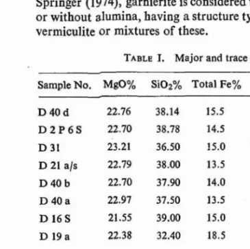
nepheline are evenly distributed within haphazardly arranged plagioclase laths. Under the microscope the rocks can be divided into two groups on the basis of the foid percentage (modal data in Table I, Nos. 1 to 4):
TABLE 1. Modal data of theralite-meiteigite-pyroxenite-carbonatite from Mer Ring
'Serial No.
:Specimen No.
2 3 4 5 6 7 8 9 10 11 12
Plagioclase 32.9 Pyroxene 34.5 Brown amphibole Biotite 7.5 -Olivine 4.5 Nepheline 2.0 Sodalite 0.8 Apatite 3.7 Chlorite Sphene 'Opaques 14.2 -Carbonate
41.7 28.0 20.3
24.6 40.0 42.3
4.0 1.4
6.8 3.1 0.9
3.8 3.6 1.3
4.5 9.1 13.8
1.1 5.6
4.6 1.2 1.1
2.7
0.6
9.9 14.2 10.2 52.6 8.5 0.9 16.2 3.8 5.0 2.5 9.9 55.7 2.1 10.4 2.7 15.0 1.9 4.5 7.7
52.5 52.6 80.5
3.6 3.2
8.0 12.9 5.4
8.7
13.9 15.3
2.2
1.5 3.4
0.2
n.s
14.0 11.078.0 1.4 10.3
2.9
4.6 6.8 5.4
2.6
3.5
8.6 0.8 15.3
91.8 69.2
1-2 Foid bearing olivine gabbro. 3 - 4 Foid olivine gabbro (i.e.Theralite). 5 - 8 Melteigite,
9 - 10 Pyroxenite.
II Carbonatite, coarse grained. 12 Carbonatite, fine grained.
(i) Foid olivine gabbro and dolerite (theralite) which fall in field No. 14 in F-P-A diagram (lUGS recommendations, 1973).
(ii) Foid bearing olivine gabbro which fall in field No. 10 in F-P-A diagram ·(IUGS recommendations, 1973).
MER RING OF MUNDWARA 457
Melteigites and Pyroxenites
Melteigites and pyroxenites are closely associated. Both are coarse grained, slightly inequigranular, melanocratic and with moderately high specific gravity. Only the frequent presence of nepheline in melteigite distinguishes it from pyroxenite (WiIfiams, Turner and Gilbert, 1965). The feldspathoidal rock was designated as rnelteigiteconsidering the following characters (lUGS. 1973):
(i) Colour index, within the range of 70to 90.
(ii) Feldspathoid content, 60to 100per cent of leucocratic minerals. (iii) Amount of sodic minerals greater than potassic minerals. (iv) Feldspar usually completely absent.
Under the microscope the melteigite is found to be constituted dominantly of pyroxene, nepheline, biotite, amphibole and olivine, while apatite, chlorite, sodalite, sphene and opaques are common accessory minerals. Large rounded to subrounded crystalsof pyroxene, showingzoning and occasionally repeated twinning, are closely associated with tabular crystals of pyroxene and interstitial nepheline (Fig. 2b). Brown amphibole occurs at the periphery of pyroxene grains.
In thin section the pyroxenite exhibits almost the same characters as that of melteigite except the absence of feldspathoid. Pyroxene crystals are large in size and anhedral in shape. The open spaces between the large anhedral pyroxene grains are occupied by smaller pyroxene tablets, biotite and other accessory minerals e.g.
amphibole, apatite, olivine and opaques of variable shapes and sizes.
Modal compositions (TableI) of the investigated ultrabasics fall in the fields of melteigite and jacupirangite in N-M-A diagram (Sorensen, 1974,p. 17).
Carbonatites
These rocks are designated as carbonatite on the basis of their composition and intrusive relation to other rocks. Lenticular veins of carbonatite, varying in length from 6to 70m and in width from2 to 6m, are located within the Erinpura granite and closely associated with melteigite pyroxenite. Fine grained buff coloured rocks and coloured rocks and coarser grained varieties mottled with reddish brown and milky white patches are encountered. The rocks effervesce with cold dilute hydro--chloric acid. The carbonatites of Mer complex have been described in more detail
by Subrahmanyam and Rao (1977).
Under the microscope the chief variety is found to be composed almost wholly
-ofcolourless carbonate (Table I, Nos.11, 12)with three sets of cleavage. Twinkling -effectis conspicuous with characteristic high order interference colour. Staining with Alizarine red solution identifies the mineral to the calcite. Biotite, pyroxene and opaques are found as accessory minerals in sovite. The anhedral shape and the interlocking nature develop allotriomorphic granular texture. Zoned calcite crystals are developed in adjoining granitic rocks which seem to be introduced from the carbonatitic liquid ..
MINERALOGY
Plagioclase: Occurs only in theralites as slender laths, showing typical lamellar twinning with distinctly sharp lamellae of variable width. Most lamelIa are con-tinuous but in some cases they are disconcon-tinuous. Refractive indices of plagioclase is invariably higher than that of canada balsam. From the 2Vxand x' /I010values, the composition of plagioclase is found to range from