5
Information Technology and Control 2019/1/48
A Conceptual Framework for
Modelling Spatial Relations
ITC 1/48Journal of Information Technology and Control
Vol. 48 / No. 1 / 2019 pp. 5-17
DOI 10.5755/j01.itc.48.1.22246
A Conceptual Framework for Modelling Spatial Relations
Received 2018/12/10 Accepted after revision 2019/01/28
http://dx.doi.org/10.5755/j01.itc.48.1.22246
Corresponding author: [email protected]
Eliseo Clementini
Department of Industrial and Information Engineering and Economics; University of L’Aquila; via G. Gronchi 20, I-67100 L’Aquila, Italy; phone: +39 0862 434438; fax: +39 0862 434403; e-mail: [email protected]
Various approaches lie behind the modelling of spatial relations, which is a heterogeneous and interdisciplin-ary field. In this paper, we introduce a conceptual framework to describe the characteristics of various models and how they relate each other. A first categorization is made among three representation levels: geometric, computational, and user. At the geometric level, spatial objects can be seen as point-sets and relations can be formally defined at the mathematical level. At the computational level, objects are represented as data types and relations are computed via spatial operators. At the user level, objects and relations belong to a context-de-pendent user ontology. Another way of providing a categorization is following the underlying geometric space that describes the relations: we distinguish among topologic, projective, and metric relations. Then, we consid-er the cardinality of spatial relations, which is defined as the numbconsid-er of objects that participate in the relation. Another issue is the granularity at which the relation is described, ranging from general descriptions to very detailed ones. We also consider the dimension of the various geometric objects and the embedding space as a fundamental way of categorizing relations.
KEYWORDS: Spatial relations, spatial data, geographic data, geometric invariants, topological relations, projective relations, metric relations.
1. Introduction
Spatial relations have been an active research subject for thirty years. The theme is interdisciplinary and has attracted the interest of the different scientific communities, not only in computer science, but in linguistics [55], philosophy [13], and psychology [53]. In computer science, different domains, such as spa-tial databases [49], Geographic Information Systems (GIS) [38], image databases [4, 10], and Qualitative
Information Technology and Control 2019/1/48 6
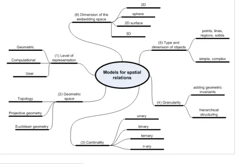
each model and the relationships between different approaches and solutions. In addition to including the state of the art, the framework can help to identify the aspects that have been less investigated so far and can still be the subject of future research. The conceptu-al framework is structured according to “orthogonconceptu-al axes”, that is, according to independent characteris-tics that allow us to define a categorization of spatial relations (Figure 1). Overall, we propose a
categoriza-tion of spatial relacategoriza-tions according to six axes: the first is the level of representation. The second relates to the properties of the geometric space. The third is the cardinality of relations. Then, we consider granulari-ty. The next axis concerns the type of objects and their dimension and the latter considers the dimension of the embedding space. In the following, each axis is discussed in a separate section.
Figure 1
The conceptual framework of spatial relations structured in six orthogonal axes
2. Levels of Representation
Spatial relations can be categorized according to three different levels of representation: the geometric level, the computational level, and the user level. The geo-metric level is an abstract representation in math-ematical terms of objects, where spatial relations between them are defined by specific geometric prop-erties: for example, in the model of the 4 intersections (4IM) [35], topological relations are defined on the
7
Information Technology and Control 2019/1/48
tween objects must be computed by spatial operators. Although the geometric level can be considered, by definition, without errors, the representation of spa-tial objects at the computational level is intrinsically affected by approximation. Real objects are repre-sented with a simplified model: for example, the his-torical classification of representations in GIS is in raster and vector representations [32]. In raster mod-els, the approximation is given by the size of the cells, whereas in vector models the approximation is given by the number of points representative of a curve. In the field of spatial database systems, the vector ap-proach is the most widespread: various proposals of database systems supporting spatial data and spatial relations have been developed (e.g., [12, 44, 48, 52]). The issues that are considered at the computational level are mainly related to the system performance in computing relations. The recent trend is that spatial database systems adhere to the specifications of the Open Geospatial Consortium (OGC): systems such as Oracle, IBM DB2, and PostgreSQL base their defini-tion of data types and spatial operators on OGC spec-ifications for SQL [57]. For example, the following is a definition of an operator to calculate a topological relation:
Crosses (g1 Geometry, g2 Geometry): Integer
The above operator finds a corresponding definition at the geometric level in the “cross” relation of the Calculus-Based Method (CBM) [27]. The set of rela-tions that are part of the OGC specification is limited to topological relations. Further work is needed to de-fine different types of spatial relations that could be included in the standard, such as cardinal directions: several proposals have been published in the litera-ture, e.g., [18, 47], to represent cardinal directions be-tween extended objects.
The problem of approximation in spatial data models and the degree of uncertainty that results from this is a question of ongoing research and is far from being solved. In some approaches, to continue to use the same models for topological relations defined at the geometric level, new data types have been defined which are able to model the uncertainty in the bound-ary of objects as a two-dimensional band around the object itself [15, 25, 30]. In addition, there may be sev-eral descriptions of the same object according to dif-ferent levels of accuracy.
The raster model is much more used in the field of im-age databases. The computation of spatial relations in image databases is less direct than in the case of spatial databases where each space object is repre-sented separately, and the relations are computed using geometric algorithms. In raster models, to com-pute relations, first the objects must be extracted, and then spatial relations are evaluated with quantitative methods, e.g., [4]. No particular effort has been made to date in adapting quantitative methods to assess spatial relations with qualitative models of spatial re-lations [14]. In some cases, the models of spatial rela-tions have been extended to work with raster data [39, 67]. Other approaches to image databases are devoted to establishing blurred measurements of qualitative spatial relationships understood as linguistic expres-sions [1]. These combinations of fuzzy quantitative models [10] or probabilistic [33] with qualitative models for evaluating spatial relations in images are also called hybrid models.
At the user level, objects and spatial relations are linked to a specific application context. We can as-sume that these concepts can be defined in a spatial ontology: there are various approaches in the litera-ture, for example, in the context of urban information systems [3] or more generally in conceptual modeling [58]. Spatial relations at this level depend strongly of various factors, such as the peculiarity of the domain, vagueness and imprecision of user terms, and the variability of terms in different countries and natural languages. To give an example, consider a navigation context: a GPS-equipped smartphone is able to give indications on the buildings that are visible by the user, who moves with a car in the city. This could be expressed with the following query: “What are the names of the buildings that are to the right and left
and forward of the user position, for which there is no other obstacle between them and which are at a
reasonable distance? ». Spatial relations used in this example will need to be transferred to the geometric level to find the equivalent mathematical definitions and at the computational level in terms of appropriate geometric types and relations [2].
Information Technology and Control 2019/1/48 8
(for example, a stream) can have multiple represen-tations at the geometric level, since a river can be represented as a single line or a complex line, or as a two-dimensional region. Therefore, a semantic spa-tial relations between two streams (for example, one river flows into another watercourse) can be mod-elled with various geometric relations based on the adopted representations [63]. There are also archi-tectural problems on how to interpret ontology at the user level in terms of data type and operators at the computational level [17].
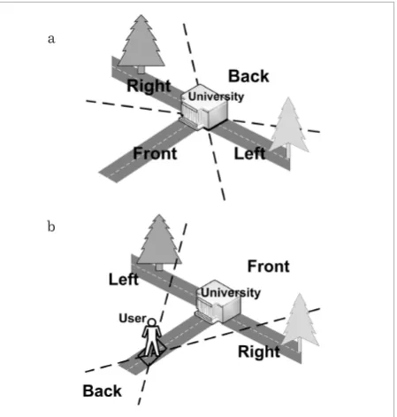
An important aspect that the user ontology on spatial relations should consider is the context information. For example, a projective relation such as “left_of” has a unique meaning when associated with certain con-text information. From the point of view of the user, the relations must be combined with the presence of a reference system to remove ambiguities in the meaning of the relation. If the context varies, often the meaning of the relation becomes ambiguous: the ex-pression “the tree to the left of the university”, which is unambiguous in a given context, becomes ambigu-ous if extrapolated from its context (see Figure 2).
Three types of reference systems are distinguished in the literature [60]: intrinsic reference systems are based on a reference object that determines the origin of the coordinate system as well as its orientation. Ex-trinsic reference systems can also inherit their origin from a reference object; However, their orientation is determined by external factors such as the direction of movement or by a conventional object used as a ref-erence point. Deictic refref-erence systems involve three objects: a primary object, a reference object, and a point of view. The orientation of the reference sys-tem is imposed on the reference object as seen by the point of view. From this basic categorization, the user ontology must describe more specific reference sys-tems as well as the possible spatial relations between object classes. A more refined ontology of frames of reference has been proposed in [18].
3. Geometric Space Properties
We propose to classify spatial relations according to three geometric categories: topological, projective, and metric, which are based on the properties of the topological, projective, and Euclidean space, respec-tively. While topological relations have been widely discussed in the literature, e.g., [22, 27, 29, 37], and the evolution of topological relations has invested all the orthogonal axes proposed in this article, the other two categories are less consolidated. Projective relations are a category of spatial relations that can be described by projective properties of space without resorting to metric properties [20]. Like topological relations, projective relations are qualitative in nature because they do not need specific measures to be explained [38]. In addition, projective relations are more accu-rate than topological relations and can serve as a ba-sis for describing relations that are not described by topology. Being an intermediate step between metric and topology, projective relations are as varied as “to the right of”, “in front of”, “between”, “along”, “sur-rounded by”, “before”, “back”, “north of”, “east of”, and so on. Although specific models have been developed for subsets of projective relations, such as cardinal directions [45], the orientation relations [50], and cardinal directions for extended objects [47], we lack a unifying model that is capable of representing all variants of projective relations. A starting point for Figure 2
Different interpretations of the term “the tree to the left of the university” according to the context: (a) the left is determined by an intrinsic property of the building, (b) the left is determined by a user's point of view
a
9
Information Technology and Control 2019/1/48
building a general model for projective relations is the 5-intersection model [5, 19, 21]. This model gives a classification of projective relations between three geometric objects in the plane, distinguishing 34 re-lations that form a JEPD set (jointly-exhaustive and pair-wise disjoint). The latter property is essential for developing reasoning systems of relations [6,28]. As far as metric relations are concerned, such as the dis-tance between two points, they are normally meant as quantitative relations, but there are qualitative ap-proaches to describe distances that could be further investigated [26].
Figure 3
The hierarchy of geometries
lowing the axiomatic approach in geometric spaces [54], a space can be built from the previous one by adding more axioms. If a geometric property is eval-uated in the topological space, the same property will remain valid in the projective space and the Euclide-an space. The opposite is not true: if we cEuclide-an identify a property in the Euclidean space, the same property will not necessarily be valid in the projective space and the topological space. It would be more accurate to say that the property cannot be identified in these spaces. Thereafter, we limit ourselves to an informal description of the properties of the three spaces. For example, let us consider the topological proper-ty “having a hole” in a two-dimensional region, the same object embedded in a projective or Euclidean space will maintain the property to have a hole. This property is topological because in a topological space, we have the formal means to identify it. A topological property is also called a topological invariant, because the property is valid after the application of any topo-logical transformation. More formally, a topotopo-logical transformation is a bi-continuous transformation, also known as rubber “sheeting” or elastic transfor-mation, i.e., the topological space is a kind of rubber sheet that can be distorted at will as long as you do not make a hole and you do not tear. In addition, a topolog-ical relation between two objects such as “overlap” is invariant following a topological transformation. topology
projective geometry
Euclidean geometry
The three spaces are not independent between them, but they are hierarchically linked (see Figure 3). Fol-Table 1
Categorization of spatial relations by crossing geometric space and cardinality
Geometric space/
cardinality unary binary ternary n-ary
topological
two separate components
one hole
A touch B
overlap
network
projective
concave
four points of order 0
A inside concavity of B
A between B and C
surrounded by
metric
four angles of 90° degrees
A bigger than B
equidistant
Information Technology and Control 2019/1/48 10
If we consider a projective property as “being a trian-gle”, such a property is true if we include the object in a projective or Euclidean space, but not true in a to-pological space, since the property cannot be defined in topology: there is no way to distinguish internally such objects (in topology a triangle can be trans-formed into a circle). Similarly to topological proper-ties, a projective property can be defined inside a pro-jective space by saying that a propro-jective property is a projective invariant, that is, it does not change after a projective transformation. Therefore, a projective transformation is a transformation that preserves the collinearity of three points in space. An example of a projective relation is a point “to the right” of an oriented line. This relation is preserved after a projec-tive transformation.
Finally, if we consider the metric property of a poly-gon “having a right angle (90°)”, including the object in a projective or topological space, we lose the ability to distinguish this property. A right angle is a charac-teristic that is preserved after roto-translation, but it will not be preserved after a projective transforma-tion or topological transformatransforma-tion. After a projective transformation, we will still have a polygon, but the measurement of this particular angle will be different from 90°. A summary of the examples for the three geometric types combined with the cardinality axis of the next section is given in Table 1.
4. Cardinality
Spatial relations can be classified with respect to their cardinality, i.e., the number of objects involved in the relation. While binary relations are the most commonly admitted, it is useful and, in some cases, necessary to consider other cardinalities. To be com-plete, we can also consider unary relations, which correspond to geometric properties of single spatial objects. Mathematically, a binary relation between two sets A and B is a subset of the Cartesian product
A × B. Topological relations are mainly binary because they are based on the connection property of two ob-jects (two sets of points can either have common parts or not). Rarely, ternary topological relations have been taken into account [40]. Ternary relations involve three objects A, B and C. This category is very
useful for projective relations, which are based on three-point collinearity (the fundamental geometric invariant in a projective space) [7]. A typical ternary relation is “between” [11]. The results on reasoning mechanisms with ternary relations, such as composi-tion tables [46], have yet to be developed. Qualitative spatial reasoning on ternary relations is a topic of ac-tive research [6, 28, 66]. More rarely, in the literature, quaternary relations are envisaged: for example, in order to illustrate the notion of surrounding [59]. In general, when more than three objects are concerned, we talk about n-ary relations. In Table 1, we propose some examples of spatial relations by combining the properties of geometric spaces and cardinality.
5. Granularity
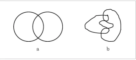
Another issue is the degree of granularity with which spatial relations can be described. For example, let us consider a topological relation that expresses the fact that two regions overlap, the same topological re-lation can be refined with more granularity by speci-fying the number of distinct parts in the intersection of the regions. For example, in Figure 4, the two cases can be described as an ‘overlap’ relation. If we consid-er the numbconsid-er of separate parts, we are able to make a difference between the two cases. Therefore, if we limit ourselves to a more abstract level of granulari-ty, a relation can make a coarse subdivision of possi-ble geometric configurations without distinguishing the more detailed aspects; by adding a more detailed property to the relation, we can subdivide the possible configurations in different more detailed subclasses.
Figure 4
Effect of adding greater granularity to the “overlap” relation with the number of distinct components of the intersection of regions: (a) equal to 1; (b) equal to 2
11
Information Technology and Control 2019/1/48
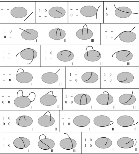
Figure 5
The 31 different relations between lines and regions in the DE+9IM. Each box contains the cases belonging to the same case of the DEM
Figure 6
A decision tree for projective relations between points
23 ?????????23 ?
? ? ? ?'%???!??????.-/??"????? ??????/? ? ?
? ? ? ? 0? ? ? ?????? #????4&(0?'*5/???? ? ? ? 0? ? ? ? -> ?2-3???"???(?!? ? ? ? ? ? ? "? 0? ? ? ? ? ? #? 4'+5/? ? ? ??????? ??0?!?????0?
? 0? ? ?
?;?>"??<?230?? ;?>??<?23?4&+50??? .-? 4&'5/? #? " ? !? ? ? 0? !? !? ? ? ? ? ? ? ? ? ? ? ? ? /? ? "0? ? .-? ?
"? ? ? "? ? ?
????2 30?#?2 30?
?"?2 3???/??89?
? ? ? ? ? ? ? ?/??? ??&?? ?$0?%??&0??> ???0? ? ? 0? #0? ? ? 2?!?: :3???#?1?
? ??????!? ,+???/????? ? 0? ? ? )0? !? ? ? ??'%?=????.-0? ? #? ?? ? 2? ? ? ? .-?"3/??
? ?0???? ? ? ? ? ? ? ? ? #??0?????? ? ? ? 2? *3/? ? "0? ?
− − − − − − 0 1 − − − 0 − − 0 1 − 0 0 1 − − − 1 − − 1 1 − 1 0 1 0 − − − 0 1 − − 0 0 1 − 0 0 − − 0 0 1 − 0 0 0 1 0 1 − − 0 1 1 − 0 1 0 1 3 3× ° λ ∂λ ¯ λ
−
⎟ ⎟ ⎟ ⎠ ⎞ ⎜ ⎜ ⎜ ⎝ ⎛ ∩ ∩∂ ° ∩ ∩ ∂ ∂ ∩ ∂ ° ∩ ∂ ∩ ° ∂ ∩ ° ° ∩ ° ) ¯ ¯ dim( ) ¯ dim( ) ¯ dim( ) ¯ dim( ) dim( ) dim( ) ¯ dim( ) dim( ) dim( 2 1 2 1 2 1 2 1 2 1 2 1 2 1 2 1 2 1 λ λ λ λ λ λ λ λ λ λ λ λ λ λ λ λ λ λWith respect to topological relations, several topo-logical invariants can be considered to add granular-ity to the relations [24, 36]. Based on the invariant of the content, the model of 9-intersection (9IM) is an extension of the 4IM with the addition of the concept of external objects, besides the interior and the boundary [37]. An important invariant is the di-mension of the parts of the objects, which produced a class of models, called Dimension-Extended, such as the « Dimension-Extended Method » (DEM), the « Calculus-Based Method » (CBM) [27], and the DE+9IM [23]. By expressive power of these models, we will indicate the number of topological relations that the model is able to distinguish. For example, the DE+9IM is expressed as a 3 × 3 matrix containing the dimension of the interior (λ°), boundary (
(
)
(
)
(
)
(
)
(
)
(
)
(
)
(
)
(
)
∩ ∂ ∩ ° ∩ ∩ ∂ ∂ ∩ ∂ ° ∩ ∂ ∩ ° ∂ ∩ ° ° ∩ ° – 2 – 1 2 – 1 2 – 1 – 2 1 2 1 2 1 – 2 1 2 1 2 1 dim dim dim dim dim dim dim dim dim λ λ λ λ λ λ λ λ λ λ λ λ λ λ λ λ λ λ λ ∂ ), and exterior (λ–) of the intersections. The “dim” functionreturns the highest dimension of the intersection set. The possible values in 2D space are 0, 1 and 2, for non-void intersection of points, lines and regions, re-spectively, and null (indicated with ‘__’) for the empty intersection:
(
)
(
)
(
)
(
)
(
)
(
)
(
)
(
)
(
)
∩ ∂ ∩ ° ∩ ∩ ∂ ∂ ∩ ∂ ° ∩ ∂ ∩ ° ∂ ∩ ° ° ∩ ° – 2 – 1 2 – 1 2 – 1 – 2 1 2 1 2 1 – 2 1 2 1 2 1 dim dim dim dim dim dim dim dim dim λ λ λ λ λ λ λ λ λ λ λ λ λ λ λ λ λ λ λ ∂This model is capable of distinguishing between 87 real topological relations. In order to illustrate some relations, in Figure 5, we present the sequence of 31 line/region cases for the DE+9IM, grouped by the DEM values (upper left of the DE+9IM matrix). Regarding projective relations, a similar process can be adopted for the construction of a hierarchy of re-lations, from the most general to the most specif-ic (Figure 6). For example, the collinearity of three points can be refined into the relations “between” and “nonbetween”, and in addition, considering a line ori-entation, the relation “nonbetween” can be refined in the “before” and “after” relations. The definitions of this set of relations among points are given in Table 2 (excerpt from [19]).
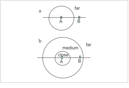
In terms of qualitative metric relations, granularity is based on the number of sub-divisions of the space [26]. For example, in Figure 7(a), the relation between
A and B is expressed as “far”, since the space is divided into two qualitative regions. In Figure 7(b), the same relation is expressed as “medium”, since the space is divided into three regions.
coll(x,y,z) U ¬coll(x,y,z)
+
∈HPyz x
rs ls
−
∈HPyz x
y=z y≠z
in
x=y x≠y
ou bt
] , [yz
x∈ x∉[y,z]
bf af
) ,
(z yz
x∈ +∞
) ,
( y
x∈ −∞yz coll
nonbt
aside
Information Technology and Control 2019/1/48 12
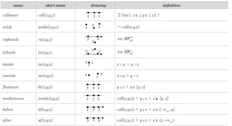
name short name drawing definition
collinear coll(x,y,z) x y z
x y z
x
y z
x
y z
x y z
x z y
x
y z
x y z
x y z x y z l z l y l x l
line ∈ ∈ ∈
∃ : , ,
coll(x,y,z) + ∈HPyz x
− ∈HPyz x
x=y ∧ y=z y
x≠ ∧ y=z
z
y≠ ∧ x∈[y,z]
coll(x,y,z) ∧ y≠ ∧z x∉[y,z] coll(x,y,z) ∧ y≠ ∧z x∈(−∞yz,y) coll(x,y,z) ∧ y≠ ∧z x∈(z,+∞yz)
¬
line l : x l x l y lz l
line ∈ ∈ ∈
∃ : , ,
coll(x,y,z) + ∈HPyz x
− ∈HPyz x
x=y ∧ y=z y
x≠ ∧ y=z
z
y≠ ∧ x∈[y,z]
coll(x,y,z) ∧ y≠ ∧z x∉[y,z] coll(x,y,z) ∧ y≠ ∧z x∈(−∞yz,y) coll(x,y,z) ∧ y≠ ∧z x∈(z,+∞yz)
¬
l, y x l y l z l l
line ∈ ∈ ∈
∃ : , ,
coll(x,y,z) + ∈HPyz x
− ∈HPyz x
x=y ∧ y=z y
x≠ ∧ y=z
z
y≠ ∧ x∈[y,z]
coll(x,y,z) ∧ y≠ ∧z x∉[y,z] coll(x,y,z) ∧ y≠ ∧z x∈(−∞yz,y) coll(x,y,z) ∧ y≠ ∧z x∈(z,+∞yz)
¬
l, z x l y l z l l
line ∈ ∈ ∈
∃ : , ,
coll(x,y,z) + ∈HPyz x
− ∈HPyz x
x=y ∧ y=z y
x≠ ∧ y=z
z
y≠ ∧ x∈[y,z]
coll(x,y,z) ∧ y≠ ∧z x∉[y,z] coll(x,y,z) ∧ y≠ ∧z x∈(−∞yz,y) coll(x,y,z) ∧ y≠ ∧z x∈(z,+∞yz)
¬
l
aside aside(x,y,z)
x y z x y z
x
y z
x
y z
x y z
x z y
x
y z
x y z
x y z x y z l z l y l x l
line ∈ ∈ ∈
∃ : , ,
coll(x,y,z) + ∈HPyz x
− ∈HPyz x
x=y ∧ y=z y
x≠ ∧ y=z
z
y≠ ∧ x∈[y,z]
coll(x,y,z) ∧ y≠ ∧z x∉[y,z] coll(x,y,z) ∧ y≠ ∧z x∈(−∞yz,y) coll(x,y,z) ∧ y≠ ∧z x∈(z,+∞yz)
¬coll(x,y,z)
rightside rs(x,y,z)
x y z x y z
x
y z
x
y z
x y z
x z y
x
y z
x y z
x y z x y z l z l y l x l
line ∈ ∈ ∈
∃ : , ,
coll(x,y,z) + ∈HPyz x
− ∈HPyz x
x=y ∧ y=z y
x≠ ∧ y=z
z
y≠ ∧ x∈[y,z]
coll(x,y,z) ∧ y≠ ∧z x∉[y,z] coll(x,y,z) ∧ y≠ ∧z x∈(−∞yz,y) coll(x,y,z) ∧ y≠ ∧z x∈(z,+∞yz)
¬
leftside ls(x,y,z)
x y z x y z
x
y z
x
y z
x y z
x z y
x
y z
x y z
x y z x y z l z l y l x l
line ∈ ∈ ∈
∃ : , ,
coll(x,y,z) + ∈HPyz x
− ∈HPyz x
x=y ∧ y=z y
x≠ ∧ y=z
z
y≠ ∧ x∈[y,z]
coll(x,y,z) ∧ y≠ ∧z x∉[y,z] coll(x,y,z) ∧ y≠ ∧z x∈(−∞yz,y) coll(x,y,z) ∧ y≠ ∧z x∈(z,+∞yz)
¬
inside in(x,y,z)
x y z x y z
x
y z
x
y z
x y z
x z y
x
y z
x y z
x y z x y z
x = y ˄ y = z
outside ou(x,y,z)
x y z x y z
x
y z
x
y z
x y z
x z y
x
y z
x y z
x y z x y z
x≠y ˄ y = z
]between bt(x,y,z)
x y z x y z
x
y z
x
y z
x y z
x z y
x
y z
x y z
x y z x y z
yline≠z ˄l xx∈l y∈l z∈l
∃ : , ,
coll(x,y,z) + ∈HPyz x
− ∈HPyz x
x=y ∧ y=z y
x≠ ∧ y=z
z
y≠ ∧ x∈[y,z]
coll(x,y,z) ∧ y≠ ∧z x∉[y,z] coll(x,y,z) ∧ y≠ ∧z x∈(−∞yz,y) coll(x,y,z) ∧ y≠ ∧z x∈(z,+∞yz)
¬
[y, z]
nonbetween nonbt(x,y,z)
x y z
x y z
x
y z
x
y z
x y z
x z y
x
y z
x y z
x y z x y z
coll(x,y,z) ˄ y≠z ˄ x l z l y l x l
line ∈ ∈ ∈
∃ : , ,
coll(x,y,z) + ∈HPyz x
− ∈HPyz x
x=y ∧ y=z y
x≠ ∧ y=z
z
y≠ ∧ x∈[y,z]
coll(x,y,z) ∧ y≠ ∧z x∉[y,z] coll(x,y,z) ∧ y≠ ∧z x∈(−∞yz,y) coll(x,y,z) ∧ y≠ ∧z x∈(z,+∞yz)
¬
[y, z]
before bf(x,y,z)
x y z x y z
x
y z
x
y z
x y z
x z y
x
y z
x y z
x y z x y z
coll(x,y,z) ˄∃ yline≠z ˄l: x x∈l,y∈l,z∈l coll(x,y,z)
+ ∈HPyz x
− ∈HPyz x
x=y ∧ y=z y
x≠ ∧ y=z
z
y≠ ∧ x∈[y,z]
coll(x,y,z) ∧ y≠ ∧z x∉[y,z] coll(x,y,z) ∧ y≠ ∧z x∈(−∞yz,y) coll(x,y,z) ∧ y≠ ∧z x∈(z,+∞yz)
¬
(–∞yz, y)
after af(x,y,z)
x y z x y z
x
y z
x
y z
x y z
x z y
x
y z
x y z
x y z x
y z coll(x,y,z) ˄∃ yline≠z ˄l: x x∈l,y∈l,z∈l coll(x,y,z)
+ ∈HPyz x
− ∈HPyz x
x=y ∧ y=z y
x≠ ∧ y=z
z
y≠ ∧ x∈[y,z]
coll(x,y,z) ∧ y≠ ∧z x∉[y,z] coll(x,y,z) ∧ y≠ ∧z x∈(−∞yz,y) coll(x,y,z) ∧ y≠ ∧z x∈(z,+∞yz)
¬
(z, +∞yz) Table 2
The definitions of projective relations between points. The symbols HPHPyz+yz+ and HPHPyz−yz− indicate the half-plane, respectively, to the right and left of the yz oriented line. The notations (–∞yz, y), [y, z] and (z, +∞yz) represent the three intervals in which
the yz oriented line is subdivided by the two points y and z: these two points belong to the central interval.
6. Type and Dimension of Objects
Spatial relations are also classified according to the type and dimension of the geometric objects to which they refer. The dimension 0, 1, 2 corresponds to points, lines, and regions, respectively. Each of them can be of a different type: commonly, we distinguish between simple and complex objects (see Figure 9). The simple regions of the plane are regularly closed, with the interior and exterior connected; simple re-gions are therefore topologically equivalent to a disk. The simple lines are lines with only two limit points and no self-intersections (they are in a one-to-one match with an interval). Complex areas can have sep-arate parts and holes. Complex lines can have more than two border points, separate parts, and intersec-tions with themselves. The complex points are the union of several simple points.Historically, most models of spatial relations have been initially developed for simple objects and then extended to complex objects. Depending on the type
of geometry and the dimension, the models are able to distinguish a certain number of relations. For ex-ample, the 9IM is capable of distinguishing 33 topo-logical relations between two simple lines. Table 3 is a summary of the number of topological relations for various models [23]. Relations between regions are indicated with R/R, between lines and regions with L/R, between points and regions with P/r, between lines with L/L, between points and lines with P/L and between points with P/P.
13
Information Technology and Control 2019/1/48
7. Dimension of the Embedding Space
The dimension of the space where objects are defined is very important for the classification of spatial rela-tions. The reason we are discussing this issue as last point is due to the fact that most of the work on spa-tial relations concerns the 2D plane. The use of other spaces is therefore a subject of research. Among the existing work on topology, we mention an extension of the 9IM to 3D space [68] and another approach that also considers the dimension of the parts of the objects [9]. The CBM has been extended to 3D space in [65]. With regard to projective relations, the 5-in-tersection model [19] was extended to 3D in [8]. In addition to 2D and 3D embedding spaces, there are other spaces that are important in some applications. For GIS applications, it would be interesting to study spatial relations on a spherical surface. There is not much work in this research direction, with the excep-Figure 7Different granularities for qualitative distances: (a) two subdivisions of space; (b) three subdivisions of space.
Figure 9
Examples of objects of different types and dimensions: (a) simple point; (b) simple line; (c) simple region, (d) complex point; (e) line with more than two boundary points and self-intersections; (f) region with separate parts and holes. For the sake of clarity, the point size is exaggerated
Table 3
Summary of topological relations for all models and for all dimensions between simple objects
Table 4
Number of topological relations between two complex spatial objects for the 9IM
Figure 8
Different granularities for qualitative orientations: (a) four subdivisions of space; (b) eight subdivisions of space
A B
far
A B
close
far medium a
b
A B north
south west
A B N
E
S W
NW
SW SE
NE
a b
tion of few contributions about topological relations [34] and projective relations [16]. In urban applica-tions, it is important to examine 3D objects that are anchored to the Earth’s surface with an added vertical direction: work on visibility relations between such objects has been preliminary carried out in [41, 43, 64].
8. Conclusion
In this paper, we have described a conceptual frame-work for spatial relations modeling. Spatial relations find applications in many endeavors, from spatial databases to crowdsourced geoinformation [42, 56], from geographic information retrieval to indoor nav-igation [61]. The framework categorizes spatial rela-tions in six independent criteria (orthogonal axes). The proposed categorization is important to place all the models in a common framework, to integrate dif-ferent approaches, and to identify the areas in which there is still room to advance the research.
a b c d e f
Model/group R/R L/R P/R L/L P/L P/P total
4IM 8 11 3 16 3 2 43
9IM 8 19 3 33 3 2 68
DEM 12 17 3 24 3 2 61
DE+9IM≡CBM 12 31 3 36 3 2 87
Model/group R/R L/R P/R L/L P/L P/P total
Information Technology and Control 2019/1/48 14
With regard to the first axis, it is especially the user level that has been less investigated: a user ontology approach is suggested to bridge the gap with spatial relations at the geometric and computational levels. With regard to the second axis, it is the projective and metric relations that need more development, since topological relations have previously had a major role. Regarding cardinality, most of the past work has focused on binary relations, while higher cardinali-ty deserves much attention. Regarding granularicardinali-ty,
more research is needed because often spatial rela-tions models are defined at a coarse granularity lev-el. Regarding the fifth axis (dimension and types of objects), it is necessary to extend models that were developed for 2D simple regions to other dimensions and complex regions and lines. Finally, most models considered the 2D plane as embedding space: other embedding spaces, such as the sphere and 3D space, have been little explored so far.
References
1. Abella, A., Kender, J. R. From Images to Sentences via Spatial Relations. Proceedings of the Integration of Speech and Image Understanding: ICCV’99 Workshop, IEEE Computer Society, 1999, 117-146. https://doi. org/10.1109/ISIU.1999.824875
2. Bartie, P., Clementini, E., Reitsma, F. A Qualitative Model for Describing the Arrangement of Visible City-scape Objects from an Egocentric Viewpoint. Comput-ers, Environment and Urban Systems, 2013, 38, 21-34. https://doi.org/10.1016/j.compenvurbsys.2012.11.003 3. Berdier, C., Roussey, C. Urban Ontologies: The
Town-tology Prototype Towards Case Studies. Proceedings of Workshop of COST Action C21 Towntology − Ontolo-gies for Urban Development: Interfacing Urban Infor-mation Systems, Université de Genève, 91-102. 4. Berretti, S., Del Bimbo, A., Vicario, E. Weighted
Walk-throughs Between Extended Entities for Retriev-al by SpatiRetriev-al Arrangement. IEEE Transactions on Multimedia, 2003, 5, 52-70. https://doi.org/10.1109/ TMM.2002.802833
5. Billen, R., Clementini, E. A Model for Ternary Projective Relations Between Regions. In Bertino, E., Christodou-lakis, S., Plexousakis, D., Christophides, V., Koubarakis, M., Böhm, K., Ferrari, E. (Eds.), EDBT2004 - 9th In-ternational Conference on Extending DataBase Tech-nology, Heraklion, Crete, Greece, March 14-18, 2004, Springer-Verlag: Berlin, 2004, 2992, 310-328. https:// doi.org/10.1007/978-3-540-24741-8_19
6. Billen, R., Clementini, E. Introducing a Reasoning Sys-tem Based on Ternary Projective Relations. In Han-dling, Fisher, P. (Ed.), Developments in Spatial Data Handling, 11th International Symposium on Spatial Data Springer-Verlag: Berlin, 2005, 381-394. https:// doi.org/10.1007/3-540-26772-7_29
7. Billen, R., Clementini, E. Semantics of Collinearity Among Regions. In Meersman, R., Tari, Z., Herrero, P. (Eds.), On the Move to Meaningful Internet Systems 2005: OTM Workshops - 1st Int. Workshop on Seman-tic-Based Geographical Information Systems (SeB-GIS’05), Agia Napa, Cyprus, October 31 - November 4, 2005, Springer-Verlag: Berlin, 2005, 3762, 1066-1076. https://doi.org/10.1007/11575863_129
8. Billen, R., Clementini, E. Projective Relations in a 3D Environment. In Raubal, M., Miller, H., Frank, A., Good-child, M. (Eds.), Geographic Information Science: 4th International Conference, GIScience 2006, Münster, Germany, September 20-23, 2006, Springer: Berlin, 2006, 4197, 18-32. https://doi.org/10.1007/11863939_2 9. Billen, R., Zlatanova, S., Mathonet, P., Boniver, F. The
Dimensional Model: A Framework to Distinguish Spa-tial Relationships. In Richardson, D., van Oosterom, P. (Eds.), Advances in Spatial Data Handling - 10th Inter-national Symposium on Spatial Data Handling, Spring-er: Berlin, 2002, 285-298. https://doi.org/10.1007/978-3-642-56094-1_21
10. Bloch, I. Fuzzy Relative Position Between Ob-jects in Image Processing: A Morphological Ap-proach. IEEE Transactions on Pattern Analy-sis and Machine Intelligence, 1999, 21, 657-664. https://doi.org/10.1109/34.777378
11. Bloch, I., Colliot, O., Cesar Jr., R. M. On the Ternary Spa-tial Relation “Between”. IEEE Transactions on Systems, Man, and Cybernetics - Part B: Cybernetics, 2006, 36, 312-327. https://doi.org/10.1109/TSMCB.2005.857095 12. Cardenas, A. F., Ieong, I. T., Taira, R. K., Barker, R.,
15
Information Technology and Control 2019/1/48
13. Casati, R., Varzi, A. Parts and Places: The Structures of Spatial Representations. MIT Press: Cambridge, MA, 248, 1999.
14. Cicerone, S., Clementini, E. Efficient Estimation of Qualitative Spatial Relations Based on the Weighted Walkthroughs Model. GeoInformatica, 2003, 7, 211-227. https://doi.org/10.1023/A:1025148831131
15. Clementini, E. A Model for Uncertain Lines. Journal of Visual Languages & Computing, 2005, 16, 271-288. https://doi.org/10.1016/j.jvlc.2004.11.003
16. Clementini, E. Projective Relations on the Sphere. In Song, I.-Y. (Ed.), Advances in Conceptual Modeling – Challenges and Opportunities - ER 2008 Workshops - 2nd International Workshop on Semantic and Con-ceptual Issues in GIS (SeCoGIS 2008), Springer-Ver-lag: Berlin Heidelberg, 2008, 5232, 313-322. https://doi. org/10.1007/978-3-540-87991-6_38
17. Clementini, E. Ontological Impedance in 3D Semantic Data Modeling. In Kolbe, T. H., König, G., Nagel, C. (Eds.), International Archives of the Photogrammetry, Remote Sensing and Spatial Information Sciences XXXVIII-4, part W15 ISPRS: 5th 3D GeoInfo Conference, 3-4 No-vember 2010, Berlin, Germany, 2010, 97-100.
18. Clementini, E. Directional Relations and Frames of Reference. GeoInformatica, 2013, 17, 235-255. https:// doi.org/10.1007/s10707-011-0147-2
19. Clementini, E., Billen, R. Modeling and Comput-ing Ternary Projective Relations Between Regions. IEEE Transactions on Knowledge and Data Engi-neering, 2006, 18, 799-814. https://doi.org/10.1109/ TKDE.2006.102
20. Clementini, E., Billen, R. Projective Relations. In Shek-har, S., Xiong, H., Zhou, X. (Eds.), Encyclopedia of GIS, 2nd Edition, Springer International Publishing: New York, 2016. doi:10.1007/978-3-319-23519-6_1540-1pp. 1-10.
21. Clementini, E., Billen, R., Santic, M. Errata Corrige on “Modeling and Computing Ternary Projective Rela-tions Between Regions”. IEEE TransacRela-tions on Knowl-edge and Data Engineering, 2013, 25, 1196-1198. https:// doi.org/10.1109/TKDE.2011.239
22. Clementini, E., Cohn, A. G. RCC*-9 and CBM*. In Duck-ham, M., Pebesma, E., Stewart, K., Frank, A. U. (Eds.), Proceedings of Geographic Information Science, 8th International Conference, GIScience 2014, Vienna, Austria, September 24-26, 2014., Springer: Berlin, 2014, LNCS 8728, 349-365. https://doi.org/10.1007/978-3-319-11593-1_23
23. Clementini, E., Di Felice, P. A Comparison of Methods for Representing Topological Relationships. Informa-tion Sciences, 1995, 3, 149-178.
24. Clementini, E., Di Felice, P. Topological Invari-ants for Lines. IEEE Transactions on Knowledge and Data Engineering, 1998, 10, 38-54. https://doi. org/10.1109/69.667085
25. Clementini, E., Di Felice, P. A Spatial Model for Com-plex Objects with a Broad Boundary Supporting Queries on Uncertain Data. Data & Knowledge Engi-neering, 2001, 37, 285-305. https://doi.org/10.1016/ S0169-023X(01)00010-6
26. Clementini, E., Di Felice, P., Hernández, D. Qualitative Representation of Positional Information. Artificial Intelligence, 1997, 95, 317-356. https://doi.org/10.1016/ S0004-3702(97)00046-5
27. Clementini, E., Di Felice, P., van Oosterom, P. A Small Set of Formal Topological Relationships Suitable for End-User Interaction. In Abel, D., Ooi, B.C. (Eds.), Ad-vances in Spatial Databases - Third International Sym-posium, SSD ‘93, Springer-Verlag: Berlin, 1993, 692, 277-295. https://doi.org/10.1007/3-540-56869-7_16 28. Clementini, E., Skiadopoulos, S., Billen, R., Tarquini,
F. A Reasoning System of Ternary Projective Rela-tions. IEEE Transactions on Knowledge and Data En-gineering, 2010, 22, 161-178. https://doi.org/10.1109/ TKDE.2009.79
29. Cohn, A. G., Bennett, B., Gooday, J., Gotts, N. Qualitative Spatial Representation and Reasoning with the Region Connection Calculus. GeoInformatica, 1997, 1, 275-316. https://doi.org/10.1023/A:1009712514511
30. Cohn, A. G., Gotts, N. M. The ‘Egg-Yolk’ Representation of Regions with Indeterminate Boundaries. In Bur-rough, P. A., Frank, A. U. (Eds.), Geographic Objects with Indeterminate Boundaries, Taylor & Francis: London, 1996, 2, 171-187.
31. Cohn, A. G., Hazarika, S. M. Qualitative Spatial Repre-sentation and Reasoning: An Overview. Fundamenta Informaticae, 2001, 46, 1-29.
32. Couclelis, H. People Manipulate Objects (but Cultivate Fields): Beyond the Raster-Vector Debate in GIS. Pro-ceedings of Theories and Methods of Spatio-Temporal Reasoning in Geographic Space, Pisa, Italy, Septem-ber 21-23, 1992, 65-77. https://doi.org/10.1007/3-540-55966-3_3
Position-Information Technology and Control 2019/1/48 16
ing. IEEE Transactions on Pattern Analysis and Ma-chine Intelligence, 2005, 27, 1473-1484. https://doi. org/10.1109/TPAMI.2005.186
34. Egenhofer, M. J. Spherical Topological Relations. In Spaccapietra, S., Zimányi, E. (Eds.), Journal on Data Se-mantics III, Springer-Verlag: Berlin, 2005, 3534, 25-49. https://doi.org/10.1007/11496168_2
35. Egenhofer, M. J., Franzosa, R. D. Point-Set Topological Spatial Relations. International Journal of Geographi-cal Information Systems, 1991, 5, 161-174. https://doi. org/10.1080/02693799108927841
36. Egenhofer, M. J., Franzosa, R. D. On the Equivalence of Topological Relations. International Journal of Geographical Information Systems, 1995, 9, 133-152. https://doi.org/10.1080/02693799508902030
37. Egenhofer, M. J., Herring, J. R. Categorizing Binary To-pological Relationships Between Regions, Lines, and Points in Geographic Databases; Department of Survey-ing EngineerSurvey-ing, University of Maine, Orono, ME, 1991. 38. Egenhofer, M. J., Mark, D. M. Naive Geography. In
Frank, A. U., Kuhn, W. (Eds.), Spatial Information The-ory: A Theoretical Basis for GIS - International Con-ference, COSIT’95, Springer-Verlag: Berlin, 1995, 988, 1-15. https://doi.org/10.1007/3-540-60392-1_1
39. Egenhofer, M. J., Sharma, J. Topological Relations Be-tween Regions in R2 and Z2. In Abel, D., Ooi, B. C. (Eds.), Advances in Spatial Databases - Third International Symposium, SSD ‘93, Springer-Verlag: Berlin, 1993, 692, 316-336.
40. Favetta, F., Laurini, R. About Precision and Integrity in Visual Query Languages for Spatial Databases. Seventh International Conference on Database Systems for Ad-vanced Applications (DASFAA 2001), 18-20 April 2001, Hong Kong, China, IEEE Computer Society: Los Alam-itos, CA, 2001, 286-293. https://doi.org/10.1109/DAS-FAA.2001.916389
41. Fogliaroni, P., Clementini, E. Modeling Visibility in 3D Space: A Qualitative Frame of Reference. In Breunig, M., Al-Doori, M., Butwilowski, E., Kuper, P. V., Benner, J., Haefele, K. H. (Eds.), 3D Geoinformation Science: The Selected Papers of the 3D GeoInfo 2014, Springer: Berlin, 2015, LNG&C, 243-258.
42. Fogliaroni, P., D’Antonio, F., Clementini, E. Data Trust-worthiness and User Reputation as Indicators of VGI Quality. Geo-Spatial Information Science, 2018, 21, 213-233. https://doi.org/10.1080/10095020.2018.1496556 43. Fogliaroni, P., Wallgrün, J. O., Clementini, E., Tarquini,
F., Wolter, D. A Qualitative Approach to Localization
and Navigation Based on Visibility Information. In Stewart Hornsby, K., Claramunt, C., Denis, M., Ligozat, G. (Eds.), Spatial Information Theory, 9th International Conference, COSIT 2009, Aber Wrac’h, France, Sep-tember 2009, Springer: Berlin, 2009, 5756, 312-329. https://doi.org/10.1007/978-3-642-03832-7_19
44. Frank, A. U. MAPQUERY: Data Base Query Language for Retrieval of Geometric Data and their Graphical Representation. ACM Computer Graphics, 1982, 16, 199-207. https://doi.org/10.1145/965145.801281 45. Frank, A. U. Qualitative Reasoning About Distances and
Directions in Geographic Space. Journal of Visual Lan-guages and Computing, 1992, 3, 343-371. https://doi. org/10.1016/1045-926X(92)90007-9
46. Freksa, C. Temporal Reasoning Based on Semi-Inter-vals. Artificial Intelligence, 1992, 54, 199-227. https:// doi.org/10.1016/0004-3702(92)90090-K
47. Goyal, R., Egenhofer, M. J. The Direction-Relation Ma-trix: A Representation of Direction Relations for Ex-tended Spatial Objects. Proceedings of UCGIS Annual Assembly and Summer Retreat, Bar Harbor, ME. 48. Güting, R. H. Geo-Relational Algebra: A Model and
Query Language for Geometric Database Systems. In Schmidt, J. W., Ceri, S., Missikoff, M. (Eds.), Advances in Database Technology - EDBT’88, Proceedings of the International Conference on Extending Database Tech-nology, March 14-18, 1988, Venice, Italy, Springer-Ver-lag: Berlin, 1988, 303, 506-527.
49. Güting, R. H. An Introduction to Spatial Database Sys-tems. The VLDB Journal, 1994, 3, 357-400. https://doi. org/10.1007/BF01231602
50. Hernández, D. Maintaining Qualitative Spatial Knowl-edge. In Frank, A. U., Campari, I. (Eds.) Spatial Infor-mation Theory: A Theoretical Basis for GIS - European Conference, COSIT’93, Springer-Verlag: Berlin, 1993, 716, 36-53. https://doi.org/10.1007/3-540-57207-4_4 51. Hernández, D. Qualitative Representation of Spatial
Knowledge. Springer-Verlag: Berlin, 804, 202, 1994. https://doi.org/10.1007/BFb0020328
52. Herring, J. TIGRIS: A Data Model for an Object-Ori-ented Geographic Information System. Comput-ers and Geosciences, 1991, 18, 443-452. https://doi. org/10.1016/0098-3004(92)90074-2
53. Ishikawa, T., Montello, D. R. Spatial Knowledge Ac-quisition from Direct Experience in the Environ-ment: Individual Differences in the Development of Metric Knowledge and the Integration of Separately Learned Places. Cognitive Psychology, 2006, 52, 93-129. https://doi.org/10.1016/j.cogpsych.2005.08.003
17
Information Technology and Control 2019/1/48
Mathematical Society, 1893, 2, 215-249. https://doi. org/10.1090/S0002-9904-1893-00147-X
55. Lautenschütz, A.-K., Davies, C., Raubal, M., Schwering, A., Pederson, E. The Influence of Scale, Context and Spatial Preposition in Linguistic Topology. In Barkow-sky, T., Knauff, M., Ligozat, G., Montello, D. R. (Eds.), Spatial Cognition V Reasoning, Action, Interaction - International Conference Spatial Cognition 2006, Sep-tember 24-28, 2006, Bremen, Germany, Springer: Ber-lin, 2007, 4387, 439-452.
56. Martella, R., Kray, C., Clementini, E. A Gamification Framework for Volunteered Geographic Information. In Bação, F., Santos, M. Y., Painho, M. (Eds.), AGILE 2015 - Geographic Information Science as an Enabler of Smarter Cities and Communities, Lecture Notes in Geoinformation and Cartography, Springer: Berlin, 73-89, 2015. https://doi.org/10.1007/978-3-319-16787-9_5 57. OGC. Geometry Object Model. In OpenGIS
Implemen-tation Specification for Geographic Information - Sim-ple Feature Access - Part 1: Common Architecture, 2011, 13-32.
58. Parent, C., Spaccapietra, S., Zimanyi, E. Conceptual Mod-eling for Traditional and Spatio-Temporal Applications - The MADS Approach; Springer: Berlin, 466, 2006. 59. Portillo, M. C., Pomerantz, J. R., Zimmerman, S.
Eval-uating Grouping via Emergent Features: A Systematic Approach. Fifth Annual Meeting of the Vision Science Society, May 7, 2005, Sarasota, FL, 2005.
60. Retz-Schmidt, G. Various Views on Spatial Preposi-tions. AI Magazine, 1988, 9, 95-105.
61. Russo, D., Zlatanova, S., Clementini, E. Route Direc-tions Generation Using Visible Landmarks. In Clara-munt, C., Li, K.-J., Zlatanova, S. (Eds.), Sixth ACM SIGSpatial International Workshop on Indoor Spatial
Awareness (ISA 2014), ACM, 2014, 1-8. https://doi. org/10.1145/2676528.2676530
62. Schneider, M., Behr, T. Topological Relationships Be-tween Complex Spatial Objects. ACM Transactions on Database Systems, 2006, 31, 39-81. https://doi. org/10.1145/1132863.1132865
63. Tarquini, F., Clementini, E. Spatial Relations Between Classes as Integrity Constraints. Transactions in GIS, 2008, 12, 45-57. https://doi.org/10.1111/j.1467-9671.2008.01134.x
64. Tarquini, F., De Felice, G., Fogliaroni, P., Clementi-ni, E. A Qualitative Model for Visibility Relations. In Hertzberg, J., Beetz, M., Englert, R. (Eds.), 30th An-nual German Conference on Artificial Intelligence (KI 2007), Springer, 2007, 4667, 510-513. https://doi. org/10.1007/978-3-540-74565-5_52
65. van Oosterom, P., Vertegaal, W., van Hekken, M., Vijl-brief, T. Integrated 3D Modelling Within a GIS. In Mo-lenaar, M., Hoop, S. D. (Eds.), Avanced Geographic Data Modelling: Spatial Data Modelling and Query Languag-es for 2D and 3D Applications, Netherlands Geodetic Commission: Delft, The Netherlands, 40, 80-95, 1994. 66. Wallgrün, J. O., Frommberger, L., Wolter, D., Dylla, F.,
Freksa, C. A Toolbox for Qualitative Spatial Represen-tation and Reasoning. Proceedings of Spatial Cognition V: Reasoning, Action, Interaction: International Confer-ence Spatial Cognition, Bremen, Germany, 2006, 39-58. 67. Winter, S., Frank, A. U. Topology in Raster and
Vec-tor Representation. GeoInformatica, 2000, 4, 35-65. https://doi.org/10.1023/A:1009828425380