LAN D SCA PE
R E V I E W
A S o u t h e r n h e m i S p h e r e J o u r n A L o F
L A n D S C A p e A r C h i t e C t u r e
t h e m e
new Directions in Landscape heritage
ContributorS
Andrew MacKenzie and Andrew Saniga, introduction: new Directions in
Landscape heritage
Jacky Bowring, revisiting utopia: how a Legacy of idealistic plans resonates
with Christchurch’s rebuild
Paul Walker, Jane Grant and David Nichols, monarto’s Contested Landscape
Lauren Pikó, milton Keynes and the Liquid Landscape, 1967–78
Saren Reid, haptic and olfactory experiences of the perth Foreshore: Case
Studies in Sensory history
Cameron Logan, the national trust and the heritage of Sydney harbour
Nancy Vance, Seascapes: Shaped by the Sea: book review
V o L u m e 1 6 ( 1 )
iSSn 2253–1440
published november 2015
© edition: School of Landscape Architecture, Lincoln university. © text and illustrations: individual contributors, unless otherwise noted.
1
L a n d s c a p e r e v i e w 1 6 ( 1 ) p a g e s 1 – 1
Jacky Bowring is Professor of Landscape Architecture, School of Landscape Architecture, Faculty of Environment, Society and Design, PO Box 85084, Lincoln University, Christchurch 7647, Canterbury, Aotearoa New Zealand. Telephone: +64–3–423–0466 Email: [email protected]
Foreword
jacky bowring
foreword
i
n christchurch, the home of Landscape Review, the significance of heritage was heightened as a result of the earthquakes of 2010 and 2011. Before the quakes, like any familiar dimension of the landscape, heritage had been simply a taken-for-granted aspect of the city fabric. But in the face of economic challenges, issues of safety, and a literal shake-up of our understanding of place, heritage has become a vigorously debated topic in the city.This special issue on New Directions in Landscape Heritage is a timely exploration of our connections with historic elements of the landscape, not just for Christchurch, but in all places where the landscape is changing. Whether through the rapid change of an earthquake or fire, or the slow change of sea-level rise or pollution, traces of the past are vulnerable to erasure.
These papers all come from one conference, the 12th Australasian Urban History/Planning History Conference, 2014. It was due to the vision of two speakers at the conference, Andrew Saniga and Andrew MacKenzie, that the papers included here came together as a volume. Through this idea of gathering heritage articles together, the issue contributes a useful body of thinking to the ongoing discourse on the topic. I’m very grateful to Andrew and Andrew for their initiative in proposing the special issue and their subsequent helpful contributions to the process of peer reviewing and putting the issue together.
2
L a n d s c a p e r e v i e w 1 6 ( 1 ) p a g e s 2 – 5
Andrew Saniga, University of Melbourne, Parkville, VIC 3010, Australia.
Telephone: +61–3–8344–7056 Email: [email protected]
Andrew MacKenzie, University of Canberra, Canberra, ACT 2601, Australia.
Telephone:+ 61–2–6201–2577
Key words Cultural heritage Landscape Urbanism Planning Design
introduction: new directions in
Landscape Heritage
andrew mackenzie and andrew saniga
editoriaL
g
lobally, the heritage movement can be traced back to the mid-nineteenth century when the way of valuing places and objects, including natural places, began to change. the development of various international charters in the twentieth century, particularly as a result of the destructive forces of war, saw an increasing awareness and an expansion of conservation activity paralleled by advances in theories and practices in this area. in general, architectural monuments were by far the most talked-about aspects, perhaps matching the growing movement focused on nature conservation, which sometimes ‘spilled over’ into urban landscapes. in the broadest sense, however, appreciation of cultural landscapes has been comparatively slow to take hold: it was largely not until the early 1970s that charters for their conservation and management appeared on the list of concerns in australia.since the 1980s the appreciation of heritage and landscape has certainly grown. with advances such as the Burra charter (1979) in australia, which was in part a rejection of the architectural emphasis of european charters, significant cultural landscapes – both designed and organically evolved – have been identified and protected. Anecdotal evidence suggests that, in some parts of australia, growing numbers of applications for registration are sitting on desks in bureaucratic domains charged with protecting and managing our heritage landscapes. in new Zealand, an ongoing concern is that registration of heritage sites is mismatched with their particular need for protection. More recently, the european Landscape convention in 2004 (council of europe treaty series no. 176) and the draft recommendations for evaluating Historic Urban Landscapes (Unesco, 2005) have elevated the topic to international status. similarly, organisations such as documentation and conservation – Modern Movement (docoMoMo), predominantly formulated on the basis of modern architecture, have subcommittees actively promoting planning and landscape concerns to various degrees of success. although methods for understanding and evaluating heritage landscape values are evolving, it is also clear that the range of issues and complexity of debate are far-reaching and complex. a sample of current issues includes tensions between colonial and indigenous landscapes and people, between natural, ecological and designed landscapes, and between sustainability and conservation agendas; and the peculiarities of dealing with living and changing landscapes (as distinct from static objects).
3
a n d r e w m a c k e n z i e a n d a n d r e w s a n i g a
can we interpret heritage landscapes in the contemporary experience of physical landscape? How do we assign heritage values in the context of the breadth of landscape qualities? For example, how do we place heritage value on the failures of the past? How should landscapes that represent redundant ideas (particularly in terms of past management practices) be interpreted, if at all?
in this special issue we are particularly interested in new research methods and theoretical propositions as well as in case studies that highlight new scholarly approaches to understanding landscape heritage. Landscapes present particular challenges from a heritage perspective, and it is the contrasts and the comparisons that emerge in these research papers that should stimulate interest in reconsidering the value of heritage landscapes. all of the authors deal with the theme of urbanism at the large scale, but each approaches it in a subtly different way: urban visions unrealised, urban form expressed through language, the loss of urban form, and urban ‘indicators’ acting like punctuation in a larger fabric. The synergies between the papers offer confidence in the need for new directions for conceiving landscape heritage value yet, interestingly, only one paper was authored by an academic whose primary scholarship is in the field of landscape research. it should be acknowledged that all authors contributed to the 12th australasian Urban History/planning History conference held in wellington in February 2014.
Jacky Bowring considers landscape heritage in the context of both natural disasters and new Zealand’s early urban planning history. she uses notions of utopia as a device to examine the role of landscapes in visioning and realising the recovery of christchurch after the earthquakes of 2010–11. on a subject close to her heart, Bowring’s essay offers the reader the opportunity to reflect on how landscape traditions such as the picturesque and, in contrast, naturalistic endemic plantings can provide a valuable resource for a city seeking to recover tangible and intangible ideas of utopia in its journey to recover from crisis. although her reference to resilience is brief, she offers an alternative perspective on the conventional definition used in landscape architecture scholarship. Resilience in the context of disaster refers to the way a system (or community) copes, in contrast to a literal ecological interpretation, which focuses on a system’s capacity to adapt to new conditions (walker and salt, 2012). Bowring provokes us to consider landscape’s capacity to support both interpretations: the connection to the utopian roots is evident in the recovery of picturesque representations while, at the same time, new ideas for a naturalised version of the avon river park provide a new representation of the picturesque that is particularly ‘christchurchian’. thus the landscape becomes the medium for adapting to, and coping with, the process of reinterpretation as well as the recovery of the city’s heritage.
4
a n d r e w m a c k e n z i e a n d a n d r e w s a n i g a
superstudio. in parallel with the extraordinary aims and ambitions for the proposed environmentally sensitive urban and landscape design was a large-scale reafforestation proposal, which was at least partially enacted. As the authors explain, the unrealised ideals of urban planning, architecture and landscape architecture are in an uncanny way recalled in the serendipitous outcomes of Monarto’s ‘greening’ – as seemingly desolate or obscure as that greening activity may appear to the passer-by today. the narrative resonates with probably countless other urban and rural experiments that have ‘gone wrong’ and, as the authors suggest, each of these ‘failures’ is a complex and distinctive narrative in its own right. the complex relationships between landscape, heritage and change over time, particularly when it comes to horticultural and ecological evolution, and the appreciation of relics, make for a compelling sense of landscape in the context of historical understandings and the traces of fabric with which one is presented.
The similarities and differences in approach to the special issue theme are evident in the above two papers. whereas Bowring encourages the reader to critically examine how contemporary blueprints for the rebuilding of inner Christchurch draw on utopian vivid blue-green landscapes filled with happy citizens, Grant et al reflect on how the millions of trees planted in the place where the Monarto city centre would have stood bring superstudio and its anti-city imagery to mind. at the same time, both papers evoke powerful images of how heritage interpretation can transcend the often prosaic approaches to heritage conservation when landscapes are considered. the authors’ capacity to question meaning and value of the tangible heritage in the physical landscape is borne out in the story of these unrealised or yet to be realised historical places.
Urban settlement and experimentation with shifting urban populations also form the basis of Lauren pikó’s paper. again, failure and lost aims are at the core, although in a different way and a different geographic context. Pikó explores the fate of Milton Keynes in england and the role that urban planning played in its conception and development. she considers metaphorical references to the new town as indicative of deeper social, political and economic agendas as well as the unfurling public perceptions – not only of Milton Keynes itself but also of national and transnational relations. she deals with the public perception of historical landscapes, and the way the landscape containing the past had ‘implied a perception that visible historical continuity was psychologically beneficial to urban residents’. she looks at changing cultural values and landscapes, along with the language, specifically metaphors, that helps define them; how the link between what we build and what we believe and stand for runs deep into the shapes, forms and contexts. the extent to which such narratives could be linked to the valuing of landscape from a heritage point of view is clear, despite the connotations attached to built environments, that is, the historical synergies between practice and place that inform our relationship to landscape. it also raises the question of scale and heritage value generally and in terms of the wider english landscape within which Milton Keynes is set. in this case, ‘interpretation’ of a heritage landscape comes, quite literally, by way of language and its use and the contexts in which it is used (political change over time).
5
a n d r e w m a c k e n z i e a n d a n d r e w s a n i g a
centuries. this paper theorises the haptic and olfactory experience of water and riverbed as it was manifested in the decline of two separate developments of the time. reid’s intent is to explore how the haptic and olfactory senses as well as the aesthetic experience make ‘people increasingly familiar with both the river and their own bodies in ways that could not be attained through visual experience alone’. the purpose for this historical account becomes clearer as the author theorises the perceptual landscape in the context of the latest development of the swan river shoreline, the elizabeth Quay waterfront. reid’s critical analysis of the community’s relationship to water, land and mud is based on the sanitising of users’ experience of such elements and could be applied to many twenty-first century urban waterfronts replete with artificial beaches. Significantly, the justification for the development on heritage grounds includes the symbolic recovery of the pre-European Swan River foreshore; a similar justification has been used in the development of Barangaroo on the sydney Harbour foreshore, as cameron Logan recounts in his paper on the preservation of urban landscapes in sydney over the past century. reid’s work in a little-researched area of landscape scholarship provides a meaningful addition to this field. Her exploration of the literal and visceral experience of water could be juxtaposed with pikó’s metaphorical exploration of water and the adjectives associated with ‘liquid’ used to describe the value and meaning of new town development. reading reid’s account provokes us to consider the city’s landscapes in a new way, in terms of the sounds and smells lost or the realisation of what new sensorial perceptions may have taken their place.
Finally, cameron Logan explores the institutional role the national trust of australia (nsw) has played in stewarding urban landscapes around sydney and along the shores of sydney Harbour in particular. as with reid’s account of the elizabeth Quay waterfront, and Bowring’s discussion of the avon river park, Logan’s paper uses a recent controversy, the Barangaroo development on the sydney Harbour foreshore, as a device to explore the historical nuances in the formation of a conservation ethic and the interrelationships of heritage organisations, activists, public bodies and designers, past and present. the conclusion Logan arrives at is not to form a view on the merits of the Barangaroo project but rather to contextualise that development in the lineage of key moments in the australian heritage movement regarding the promotion and realisation of a heritage landscape for the foreshore of Sydney Harbour. Logan reflects on the need to question ‘what it is we are trying to achieve when we protect places under the banner of heritage’. this is something that can be applied equally to the other papers in this special issue, and the ensuing discussions, we hope, will provide valuable material for comparison and debate.
reFerences
Unesco (2005) Fifteenth general assembly of states parties to the convention concerning the protection of the world cultural and natural Heritage. paris: Unesco.
6
L A N D S C A P E R E V I E W 1 6 ( 1 ) P A G E S 6 – 1 9
Jacky Bowring is Professor of Landscape Architecture, School of Landscape Architecture, Faculty of Environment, Society and Design, PO Box 85084, Lincoln University, Christchurch 7647, Canterbury, Aotearoa New Zealand. Telephone: +64–3–423–0466 Email: [email protected]
KEY WORDS Utopias
Christchurch earthquakes Happy Colony
Picturesque
Revisiting Utopia: How a Legacy
of Idealistic Plans Resonates with
Christchurch’s Rebuild
jacky bowring
REFLECTION
Imagined landscapes find their form in utopian dreaming. As ideal places, utopias are set up according to the ideals of their designers. Inevitably, utopias become compromised when they move from the imaginary into the actual. Opportunities to create utopias rely largely on a blank slate, a landscape unimpeded by the inconveniences of existing occupation – or even topography. Christchurch has seen two utopian moments. The first was at the time of European settlement in the mid-nineteenth century, when imported ideals provided a model for a new city. The
earthquakes of 2010 and 2011 provided a second point at which utopian dreaming
spurred visions for the city. Christchurch’s earthquakes have provided a unique opportunity for a city to re-imagine itself. Yet, as is the fate for all imaginary places, reality got in the way.
C
ities rarely get a second opportunity for a comprehensive redesign. Usually, the slow accumulations of time gradually change the form of cities, and thepurity of planning and design yields to the ongoing tweaking and tuning that are
part of the urban condition. Major disasters provide opportunities for the kind of comprehensive change that utopian thinking requires. Two examples offer a useful background to the Christchurch experience. The first is the Great Fire of London in 1666, when 176 hectares of the city fabric were razed, including 14,000 to 16,000 houses, leaving only the odd building standing within a mostly empty landscape (Porter, 2011). The prospect for a new vision of the City of London saw a range of plans produced, including those by Robert Hooke (the Curator of Experiments at the Royal Society and Professor of Geometry at Gresham College), army officer Valentine Knight, and most notably architect Christopher Wren (Hanson, 1989). The plans proposed urban forms that were distinctly different from the medieval city that had perished in the fire. However, as Marmot and Worthington (1986) note:
… the rush to rebuild the City so that it could again perform its economic role, inadequacy of public sector finance, the inability of the private sector to raise sufficient capital for land compensation for new roadways, canals and quays, all meant that the City was largely rebuilt along the pre-existing street pattern though with many wider streets (p 217).
7
J A C K Y B O W R I N G
placing restrictions on the height of buildings, completely demolishing the
downtown area (Baixa quarter) and ‘laying out new streets without restraint’ to
create a modern city, and even moving the city and ‘disdaining ruined Lisbon’ (Shrady, 2008, pp 153–154). Sebastião José de Carvalho e Melo (best known as the Marquês de Pombal) was responsible for driving the rebuild of the city, and recognised that too much had been invested in Lisbon to simply abandon it. Most significantly, he realised the ‘singular opportunity for renewal’ (Shrady, 2008, p 156). The rebuilt downtown has become a significant heritage site and was placed on the tentative list for World Heritage Sites in 2004 (UNESCO, nd). The United Nations Educational, Scientific and Cultural Organization (UNESCO) tentative listing citation observes, ‘Whilst similar to certain other examples (Edinburgh, Turin and London, amongst others) it is clearly superior in its radical modernity, its functionality, and the architectural quality of its programme’ (UNESCO, nd). This ‘radical modernity’ resonates with the kind of aspirational thinking that is at the core of utopian planning and presents a clear counter to the London outcome. The two cities’ experiences following disaster, and the prospect of dramatic change, set up a frame for reviewing the Christchurch experience.
For Christchurch, in the province of Canterbury on the east coast of New Zealand’s South Island, it was an intense series of earthquakes that devastated the city. Christchurch was established by English settlers, with the layout reflecting utopian thinking from afar. Christchurch’s earthquakes have provided a unique opportunity for a city to re-imagine itself, and the resonances with its past provide
insight into the persistence of some aspects of history and the transformation
of others. The recognition of heritage has changed over the past few decades to include not just the conventional ideas of important buildings but also a breadth of cultural expressions that are important for their ‘aesthetic, historic, scientific, social values, etc’ (Vecco, 2010, p 323). This broadening of heritage extends from tangible features to the intangible aspects of culture, including immaterial culture and oral traditions. This is an important development where design heritage is concerned. While many aspects of design history are tangible, including significant buildings and gardens, design is also about ideas and concepts, and these are often transmitted through documents and discussions. Utopian heritage tends to
be better represented in the intangible expressions of literature and art than the
tangible realm of the physical landscape.
Context
As a preface to a discussion of the utopian legacy and its reassertion in the
rebuild, it is useful to briefly recap on the impacts of the earthquakes on Christchurch. The first earthquake occurred on the Greendale Fault, in the countryside near Christchurch, and produced a 7.1 moment magnitude (MW)
8
J A C K Y B O W R I N G
shaking. The September earthquake produced the strongest earthquake ground-shaking recorded to date in New Zealand, with the ground near the epicentre moving at 1.25 times the force of gravity (g).
The worst was still to come. One of the aftershocks from the September quake occurred a few months later, in the middle of a weekday lunchtime, when the previously unknown Port Hills fault produced a 6.3 MW earthquake, very shallow and very close to the city. Ground-shaking in the February 2011 earthquake exceeded that from the September quake, reaching 2.2 g. Multiple strong and violent shakes caused catastrophic damage and killed 185 people. Since the first earthquake on 4 September 2010, Christchurch has experienced over 13,000 aftershocks. The ground-shaking experienced in the 6.3 MW quake in February 2011 was extreme and, in world terms, is topped only by the Japanese earthquake that occurred not long after, in March 2011. At 2.2 g, the demands placed on the built environment were severe, and engineers would not normally design structures to withstand anywhere near that degree of shaking. A cordon sealed off the central city from February 2011 until July 2013, creating an uneasy sense of dislocation, with residents alienated from this familiar landscape.
The assumptions about how earthquakes impact on cities are often based on the dramatic images of building collapses shown in the media. While fallen buildings were a major factor in Christchurch’s earthquake experience, other phenomena also contributed to the widespread impacts. Rockfall occurred on the hills to the south of the city, which are the remains of an extinct volcano, and at the location of the Port Hills fault. Lateral spreading occurred where land tried to move downhill in the shaking, especially on the margins of the rivers, with large cracks appearing and infrastructure rupturing. Liquefaction erupted silt from the ground, swamping buildings and vehicles.
Because of ground-shaking, combined with rockfall, lateral spread and liquefaction, many buildings that did not collapse in the initial large shakes were subsequently deemed unsafe, or uneconomic, to repair. Vast areas of the city and the surrounding areas are still being demolished, including around 1,500 buildings in the central city, which will amount to about 80 percent of the central business district. The Residential Red Zone contains around 8,000 houses, which have been bought by the Government and are being demolished. These homes are in areas where ground conditions or the threat of rockfall now preclude residential use. The establishment of the Residential Red Zone has been profoundly disruptive in terms of, for example, dealing with insurance issues,
and the inevitable stress that comes when people must leave their homes and
familiar neighbourhoods. Meanwhile, these abandoned areas are succumbing to nature. One aspiration for the red-zoned land is to have a large park following the Avon River, a possibility that has the potential to create a meaningful legacy for the city from the earthquakes. The waterfront in Toronto, Canada, illustrates how significant such a dramatic change in land use can be, where retreat from the water’s edge following the impacts of Hurricane Hazel in 1954 saw built-up areas replaced with a park, including a pedestrian bridge to memorialise the lives lost (Gifford, 2004, p 99).
9
J A C K Y B O W R I N G
landscape response is also just beginning. In these intervening years, the spirit of the city has changed dramatically, with temporary architecture and landscapes pioneering new urban forms. It is within this context of dramatic physical change and social upheaval that Christchurch’s utopian heritage gained new momentum.
Utopian thinking
Utopias present possibilities. They embody the aspirations of a perfect world, an ideal life, are vivid expressions of the values of their designers and are often created in a geographical vacuum. The challenge is to find that perfect, untouched, uncontaminated place in which to locate these utopias. Yet the landscape is never benign or mute, and the ideal of a utopia is always at the mercy of the imperfection of humans as much as the quirks of topography, climate and ecology.
The term Utopia was coined by Thomas More in his eponymous book of 1516, in which he used the neologism to express literally a ‘non-place’, and also a ‘good place,’ reflecting the homophone eutopia (More, 2002/1516). Utopias and cockaignes represented yearnings for other places and perfect worlds. While cockaignes were built on the mythical possibility of a land of plenty, utopias
required a more structured vision about how a perfect place should be. The late sixteenth and seventeenth centuries were a fertile time of utopian dreaming, including in the work of More, as well as Tommaso Campanella’s City of the Sun (2009/1623), and the many versions of ideal cities of the Renaissance (see Benevolo, 1980, pp 535–604).
New Zealand has a particularly strong relationship with the idea of utopia. Sargent (2010) highlights how those colonies based on settlement, such as North and South America, South Africa and New Zealand, were productive of utopian visions. Colonies based on exploitation or the removal of problems, including the exporting of convicts to Australia, were not so readily aligned with the idea of a perfect world. New Zealand’s resonance with utopian thinking can be related to three conditions: location, timing and emptiness.
First, in terms of location, the country’s remoteness is an attribute reinforced by its island form. As a faraway cluster of islands, New Zealand presented the prospect of a perfect, benign world hovering at the edge of the European imagination. Like More’s Utopia, islands are often the chosen geographical forms for perfect worlds, just as much as they are marginal locations to hide the negative aspects of existence (Bowring, 2011). Anthony Trollope (1882) set his utopian, or more correctly dystopian, novel The Fixed Period in an imaginary island near New
Zealand, called Britannula, in the year 1980 – which in itself is now a curiosity
in the ways that visions of the future become nostalgic once that date itself is
history. When Trollope visited New Zealand in 1875, he was evidently affected by being here. He imagined a society where euthanasia is compulsory for people in their sixty-seventh year – the so-called ‘fixed period’. Trollope was himself 67 while he wrote the book, and he died that same year.
Samuel Butler was also influenced by his visit to New Zealand, arriving in 1860. He headed for the remotest area in this remote country, up into the back country in the headwaters of Canterbury’s rivers, inland from Christchurch. His explorations, including the discovery of the Whitcombe Pass in 1861, provided
10
J A C K Y B O W R I N G
of a dystopia rather than utopia, both authors perhaps shaped in their thinking by
Charles Darwin’s On the Origin of the Species, which they both read.
A second major influence on the view linking New Zealand to utopia is the timing of European settlement. Alessio (2004) suggests that the New Zealand utopian tradition, in terms of literary utopias, may have been in part connected with the lateness of European colonisation, in addition to its distance from the Old World as noted above. The Goldilocks hypothesis of other possible planets containing life (too hot, too cold, just right) offers a parallel that suggests why
New Zealand might have represented the potential for the realisation of a utopia
akin to Thomas More’s vision. As Alessio (2004) explains:
Unlike the United States (which had developed too many Old World problems), Canada (which was too cold and partly French), South Africa (which was too black) and Australia (which with its penal settlement history had actually begun as a dystopia), New Zealand seemed to have real utopian potential (p 75).
Third is the sense of New Zealand as something of a tabula rasa,offering the latent possibilities of a blank slate. Ample access to empty land and the equality
of a society unbound by the burdens of a class system opened up real possibilities
here. Sargent (2010) notes how letters home to England from New Zealand often
referred to workers and farm owners eating at the same table and being served
the same food (p 103). As Sargent also highlights, from the time of More’s Utopia, such imaginings were associated with the idea of colonisation, in which utopias were seen as supplements to existing communities. This seemingly empty land of New Zealand reinforced that perspective. The booster writing and booster
painting1 underscored the representation of New Zealand as a perfect empty
place, enticing migrants from the Old World (Bowring, 2010).
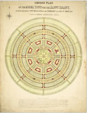
One example of a designed utopia in New Zealand is Robert Pemberton’s
(1895) plan for The Happy Colony. The Happy Colony (Figure 1) represents an interesting parallel with Christchurch, as it epitomises the way in which
geometrically designed utopias were imagined as arriving onto the tabula rasa
of a flat, empty plain reminiscent of the city’s topography. Pemberton was highly
aware of the concept of utopia and even urged his potential colonists to read
More’s Utopia. However, he cautioned that such an ideal could never be achieved
under a ‘property government’ and that it required rational labour instead of
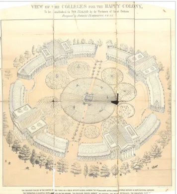
wealth as the fundamental driver. The design of the Happy Colony symbolically expresses Pemberton’s value system. At the heart of the community is a model farm (Figure 2). Surrounding it are colleges of learning and gardens in the shape of the terrestrial and celestial globes. They give physical form to his concern with how people would learn in the colony.
Pemberton planned his perfect settlement in a precise form, intending to realise it in Taranaki in the North Island of New Zealand. Like much of the planning of New Zealand, it was done without any local knowledge of the landscape or its inhabitants. At one point in Pemberton’s book, The Learned Friend asks the
Philosopher why he didn’t consider America as a suitable location for his intended
Happy Colony, to which the Philosopher replies that the continued presence of slavery there is a problem. Instead:
11
J A C K Y B O W R I N G
I believe I am right in proposing the beautiful island of New Zealand to be the spot for the first stone of the temple of happiness to be laid, as it may be said to be in its infant state, and uncorrupted by any large collection of people; and more especially as it has been held sacred, and kept free from the contamination of the offenders from the mother country … (Pemberton, 1895, p 25).
Pemberton’s utopian dreaming collided with the reality of the landscape for
which it was intended. He had urged the workmen of Great Britain to purchase 200,000 acres ‘in the neighbourhood of Taraniki [sic], now called New Plymouth’ (ibid, p 77). One end of the tract was to ‘adjoin the seashore [so] that the treasures of the deep may be at the command of the colonists’. Far from a tabula rasa, they encountered a diverse landscape, including a volcano, and an already-settled landscape. As Sargent (2010) observes, Pemberton’s Happy Colony ‘specifies the
creation of a community in an area of New Zealand that was heavily populated by
Maori as if there was no one there at all’ (p 205).
Christchurch’s planned heritage is infused with a kind of utopian dreaming. This idea of Christchurch as a utopia was even reflected in AnthonyTrollope’s (1882) The Fixed Period, which identifies ‘Little Christchurch’ in the future, mid-twentieth century, on the island of Britannula. As the narrator observes:
12
J A C K Y B O W R I N G Everything that human nature wants was there at Little Christchurch. The streams which watered the land were bright and rapid, and always running. The grasses were peculiarly rich, and the old English fruit-trees, which we had brought with us from New Zealand, throve there with an exuberant fertility, of which the mother country, I am told, knows nothing (ibid, unpaginated).
Little Christchurch is expressed as the epitome of Englishness and is the very place where the cricket match between the Britannullians and the visiting English is to be
staged. This transposition of a perfect version of Englishness onto the landscape, via the vector of New Zealand, echoes in the observations of another nineteenth-century visitor, Mark Twain, who followed in Trollope’s footsteps some 29 years later. After arriving in Christchurch, Twain (2008/1895) remarked:
It was Junior England all the way to Christchurch – in fact, just a garden. And Christchurch is an English town, with an English-park annex, and a winding English brook just like the Avon … It is a settled old community, with all the serenities, the graces, the conveniences, and the comforts of the ideal home-life. If it had an established Church and social inequality it would be England over again with hardly a lack (pp 134–135).
The layout of Christchurch was again a diagrammatic expression of ideals. While the Happy Colony had a farm at its centre, Christ Church cathedral was the symbolic centre of the city. The city’s founder, John Robert Godley, remarked in 1852:
When I first adopted and made my own the idea of this colony, it pictured itself to my mind in the colours of a Utopia. Now that I have been a practical coloniser, and have seen how these things are managed in fact, I often smile when I think of the ideal Canterbury of which our imagination dreamed (quoted in Hall, 2012, p 23).
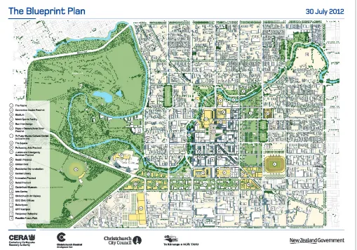
Jumping forward over a century and a half, the images of the Blueprint Plan
developed for the rebuilding of the inner city of Christchurch are emphatically
utopian, showing vivid blue-green landscapes filled with happy citizens. These
images are reminiscent of Corbusier’s Radiant City, Frank Lloyd Wright’s Broadacre and Ebenezer Howard’s Garden City (Fishman, 1982). The connections between Christchurch and the utopian Garden City are intriguingly intertwined. Howard’s book was first published in 1898 as To-Morrow: A Peaceful Path to Real Reform and then as Garden Cities of To-Morrow in 1902, half a century after Christchurch’s original plan was laid out (Howard, 2007/1902). Howard was affected by Bellamy’s(2007/1888) Looking Backward and the ideas of a
planned city based on community service. Howard (2007/1902) noted that his:
… scheme is a combination of three distinct projects which have, I think, never been united before. These are: (1) The proposals for an organized migratory movement of population of Edward Gibbon Wakefield and of Professor Alfred Marshall; (2) the system of land tenure first proposed by Thos. Spence and afterwards (though with an important modification) by Mr. Herbert Spencer; and (3) the model city of James Silk Buckingham (p 119).
13
J A C K Y B O W R I N G
in New Zealand and worked with John Robert Godley to found the Canterbury Association, and, ultimately, to create Christchurch as a Church of England settlement. Wakefield’s theory of colonisation was based on the idea of bringing a slice of English life to New Zealand, with settlers who were of good character and Christians. While this underpinned the establishment of Christchurch, as well as other settlements in New Zealand, it was also embedded in Howard’s Garden City theory. Although Christchurch is implicated in Howard’s Garden City ideals, the first time that it was actually called the Garden City is believed to be in 1906, when Sir John Gorst visited for the International Exhibition and reinforced this
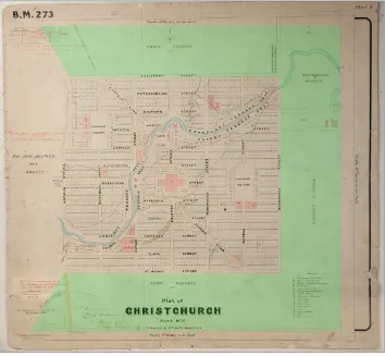
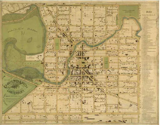
connection to the Garden City in his comment published in the Star (1906). The greenbelt of the early utopian city layout of the 1850s (Figure 3) is
reiterated in the major rebuild document, the Blueprint Plan. The design strategy of the Frame is a version of this earlier greenbelt, at a slightly different scale (Figure 4). The original vision for a greenbelt didn’t last long: 27 years later, the map of 1877 bore no trace of it (Figure 5). The same has happened with the Blueprint’s Frame, where recent images already show a substantial built footprint, obliterating much of the green space shown in the original plan. The incursions into the East Frame are predominantly residential, reflecting one of the challenges for the development of inner-city Christchurch. One of the legacies of utopian thinking in Christchurch is the low-density urban form, with even the city centre being relatively low density by international standards. Moreover, as in many New Zealand settlements, the central city’s main function over the past century has been commercial,with residential areas in the low-density suburban fabric typical of ‘garden city’ models of development.
14
J A C K Y B O W R I N G
One of the imperatives put forward for the rebuild of Christchurch is to
increase density – particularly residential density – in the city centre. Before the earthquakes, people were only slowly taking up residence in the inner-city developments, and the council was pushing for an increase in inner-inner-city population from 8,000 in 2006 to 30,000 by 2026 (Christchurch City Council, 2006). For many decades, considerable inertia has held back Christchurch suburban dwellers, who have been attached to the lifestyle of low-density living and reluctant to move to the inner city. However, a 2013 study by Opus (Greenhill, 2014) revealed that half of the respondents would be willing to live in the central city after the rebuild.
The vision of an intensively settled and vibrant inner city presents a utopian vision for Christchurch, and this is evolving as a possibility. It is necessary to find a balance between compaction and dispersal, as resilience theory suggests
that it is important to spread risk and create multiple centres in case one centre
fails (Walker and Salt, 2006). So although polycentrism might, on the one hand, suggest a counter to the idea of the compact monocentric city, on the other, it is a means of fostering adaptability and resilience. While many of the utopian diagrams are strongly hierarchical and concentric, Howard expressed this aspiration to polycentrism in his Garden City vision (Figure 6), providing further connections between the two.
Figure 4: The Blueprint Plan
15
J A C K Y B O W R I N G
Utopia and the Picturesque
Utopian planning was complemented by visualisations of landscape in the
Picturesque style. As an idealised and perfected version of nature, the Picturesque was an aesthetic convention that resonated strongly with the idea of utopia. Rather than the geometric and ordered utopian cities, the Picturesque provided a different perspective on an ideal world. The Picturesque expressed a sense of a golden age, an arcadia, as expressed in the paintings of artists like Claude Lorrain and Nicolas Poussin, and became formulated into a rule-bound approach to landscape design.
At first, the settlers in Christchurch struggled to apply the Picturesque principles they carried with them from England. Lord Lyttelton pointed out
the lack of the makings of the Picturesque on the Canterbury Plains on which
Christchurch is located, suggesting this landscape could only be described as ‘repulsive’. Nevertheless, the places that afforded the necessary elements of the Picturesque were quickly located, and Dean’s Bush in Riccarton was seen as ‘a spot with which lovers of the picturesque must be pleased’ (Adams, 1853, p 33). Further, as Mark Twain pointed out, Christchurch was ‘Junior England’, a microcosm of a bucolic English landscape inflected with the Picturesque.
Figure 5: The 1877 map of
16
J A C K Y B O W R I N G
The iconic imagery of the Avon River winding its way through the city
is bound up in Picturesque aesthetics and underpins some of the debates
over how the riparian planting should be approached. In the decade or so preceding the earthquakes, the riverbank treatment along the Avon had been the subject of a range of debates – which often degenerated into a ‘natives versus exotics’ argument. Even in the 1900s the Beautifying Association was already exploring these tensions and opportunities, with the discussion of Barker’s Plantation – a garden planted on the banks of the Avon, made up
only of native plants (Star, 1900).
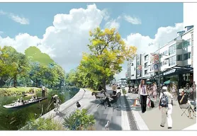
The visualisations produced for the rebuild are shot through not only with the
sense of utopian idealism noted above but also with the aesthetic conventions of
the Picturesque. The Avon River Precinct is one of the Blueprint anchor projects for the city rebuild and continues this earlier pastoral idealism (Figure 7). In their bucolic imagery, their staged social moments, the blue sky and verdant green, the images remind us of the booster paintings that artists like John Bunney produced to lure settlers to New Zealand (Bowring, 2010). Bunney himself never came to New Zealand, but he knew what people liked and he set out his views of the landscape in order to meet the desires for a particular kind of landscape, with sufficient human control to avoid total wildness, and with the sun always shining.
Figure 6: Polycentrism in Ebenezer Howard’s vision of the Garden City. ‘Garden City Concept by Howard’ by Ebenezer Howard (1850–1928) – originally published in Garden Cities of To-Morrow, Sonnenschein Publishing, 1902, Licensed under Public Domain via Commons (https://commons. wikimedia.org/wiki/File:Garden_ City_Concept_by_Howard.jpg#/ media/File:Garden_City_Concept_ by_Howard.jpg).
17
J A C K Y B O W R I N G
The imagery for future Christchurch carries this idealism forward, with
the legacies of utopia and the Picturesque embedded within the visions of the
twenty-first century city. While the imagery for the future of the river simply echoes the kind of visualisations produced internationally, conversely, they are also heavily inflected with ‘Christchurchness’ and the legacies that bind the city to its design heritage.
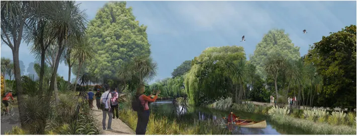
In addition, the Avon River Precinct visualisations depict a landscape where
the Picturesque legacy underpins the informal riverside indigenous planting
(Figure 8). In views like this, the Picturesque has become naturalised; it appears so familiar and is a taken-for-granted compositional device for designing the landscape. This naturalised Picturesque illustrates the transformation from a separate design language, where the indigenous and the imported maintain their autonomy as a ‘pidgin’, to a ‘creole’ where the two languages are interwoven (Bowring, 1995). The familiarity of the Picturesque as a design convention can provide a vehicle for introducing planting that challenges aesthetics and ideals. Nassauer’s (1995) theory of orderly frames for messy ecosystems advocated the
use of a familiar frame as a ‘cue to care’ to signal to people that a landscape
was intentional. This is particularly important in settings where introducing indigenous vegetation is challenged by public perceptions of ecology as messy. For Christchurch, the Picturesque can provide such an orderly frame. And, as with the visions of utopia, the Picturesque forms part of the city’s design heritage,
an unwitting touchstone as the city goes about recovering from the rupture of
the earthquakes.
Conclusion
London and Lisbon experienced starkly different outcomes from the major disasters that devastated their urban fabric. While London reverted to the status quo, Lisbon took a radical approach, akin to utopian thinking. While on the one hand utopian thinking could be considered to reflect the unrealistic ideals of past eras, on the other, it underpins the aspiration for visionary thinking. The very idea that design can enhance wellbeing is core to ideas of utopia, and for a city in the throes of post-disaster recovery this is a valuable perspective.
It is within both the tangible and intangible realms that resilience must be
grounded. For Christchurch, both the tangible heritage of the built landscape
with its planned grids and the intangible ideas of utopia and the Picturesque
provide valuable resources for a city in crisis. Through their familiarity and
18
J A C K Y B O W R I N G
aspirational qualities, these elements are part of imagining a new city. Their value
in this context challenges some of the critiques made of the baggage from the past and illustrates how a fusion of heritage and innovation can reveal new ways of
conceptualising the city and building resilience.
Acknowledgements
Thanks go to the organisers of UHPH_14: Landscapes and ecologies of urban and planning history, in particular Morten Gjerde, for the invitation to present the keynote lecture on which this paper is based. Thanks also go to Andrew Saniga and Andrew MacKenzie for their vision to bring this group of papers together as a special issue – and for their carrying out the process of review for my paper. And thanks go as always to the anonymous referees for their helpful feedback.
NOTE
1 Booster writing and booster painting were carried out to ‘boost’ the image of the
country for potential colonisers, as a kind of propaganda. In the case of booster painting, for example, artists would show fine weather and flat land – an idyllic and inviting scene that would encourage would-be settlers to come to the area.
BIBLIOGRAPHY
Adams, CW (1853) A Spring in the Canterbury Settlement, London: Longman, Brown, Green and Longman.
Alessio, D (2004) A Conservative Utopia? Anthony Trollope’s The Fixed Period (1882), Journal of New Zealand Literature,22 (Summer), pp 73–94.
Andersen, JC (1949) Old Christchurch in Picture and Story, Christchurch, Simpson & Williams. Bellamy, E (2007/1888) Looking Backward, 2000–1887, Oxford: Oxford University Press. Benevolo, L (1980) The History of the City (trans Geoffrey Culverwell), Cambridge, MA: MIT Press. Bowring, J (1995) Pidgin Picturesque, Landscape Review 2, pp 56–64.
—— (2010) Eternal Sunshine: The Search for Spotless Landscapes. In Beyond the Scene: Landscape and Identity in Aotearoa New Zealand, J Stephenson, M Abbott and J Ruru (eds), Dunedin: Otago University Press.
—— (2011) Containing Marginal Memories: The Melancholy Landscapes of Hart Island (New York), Cockatoo Island (Sydney) and Ripapa Island (Christchurch), Memory Connection 1(1), pp 252–269. Campanella, T (2009/1623) The City of the Sun: A Poetical Dialogue between a Grandmaster of the Knights Hospitallers and a Genoese Sea-captain, his Guest, Auckland:
The Floating Press.
Christchurch City Council (2006) Central City Revitalisation Strategy Stage 2. Accessed 14 August 2014, http://resources.ccc.govt.nz/files/CCRPStage2-projectcentralcity.pdf.
Fishman, R (1982) Urban Utopias in the Twentieth Century: Ebenezer Howard, Frank Lloyd Wright, and Le Corbusier, Cambridge, MA: MIT Press.
Freud, S (2002/1930) Civilization and its Discontents, London: Penguin Books.
Gifford, J (2004) Hurricane Hazel: Canada’s Storm of the Century, Toronto: Dundurn Press. Greenhill, M (2014) Would You Live in the City Centre? Press, 20 January. Accessed 28 September 2015, www.stuff.co.nz/the-press/news/9626971/Would-you-live-in-the-city-centre.
Hall, K (2012) Laying Out Foundations, Christchurch Art Gallery Bulletin B.168.
Hanson, J (1989) Order and Structure in Urban Design: The Plans for the Rebuilding of London after the Great Fire of 1666, Ekistics 334, pp 22–42.
19
J A C K Y B O W R I N G Lynch, K (1981) Good City Form, Cambridge, MA: MIT Press.
Marmot, AF and Worthington, J (1986) Great Fire to Big Bang: Private and Public Designs on the City of London, Built Environment 12(4), pp 216–233.
More, T (2002/1516) Utopia (trans and ed Robert M Adams), revised ed, Cambridge: Cambridge University Press.
Nassauer, JI (1995) Messy Ecosystems, Orderly Frames, Landscape Journal 14(2), pp 161–170. Pemberton, R (1895) The Happy Colony, London: Saunders and Otley.
Porter, S (2011) The Great Fire of London, Bungay, Suffolk: The History Press.
Sargent, LT (2010) Colonial and Postcolonial Utopias. In The Cambridge Companion to Utopian Literature, G Claeys (ed), Cambridge: Cambridge University Press.
Shrady, N (2008) The Last Day: Wrath, Ruin and Reason in the Great Lisbon Earthquake of 1755, New York: Penguin Books.
Star (1900) Christchurch Beautifying Association, Issue 6802, 23 May, p 4.
—— (1906) Sir John Gorst: His Farewell to the Garden City, Issue 8777, 14 November, p 3. Trollope, A (1882) The Fixed Period. Accessed 28 September 2015, http://ebooks.adelaide.edu. au/t/trollope/anthony/fixed_period.
Twain, M (2008/1895) Beyond the Equator, Stilwell, KS: Digireads.com.
UNESCO (no date) Pombaline ‘Baixa’ or Downtown of Lisbon. Accessed 28 September 2015,
http://whc.unesco.org/en/tentativelists/1980.
Vecco, M (2010) A Definition of Cultural Heritage: From the Tangible to the Intangible, Journal of Cultural Heritage 11(3), pp 321–324.
20
L A N D S C A P E R E V I E W 1 6 ( 1 ) P A G E S 2 0 – 3 5
Paul Walker is a professor of architecture at the University of Melbourne, Parkville, VIC 3010, Australia.
Email: [email protected]
Jane Grant is an independent scholar. Email: [email protected]
David Nichols is a senior lecturer in urban planning at the University of Melbourne, Parkville, VIC 3010, Australia.
Email: [email protected]
KEY WORDS Urban design Urban planning Environment Landscape Heritage South Australia
Monarto’s Contested Landscape
paul walker, jane grant and david nichols
REFLECTION
The proposal to develop a new city at Monarto in South Australia during the 1970s was an important project of the reforming government of Don Dunstan. Dunstan’s view was that Monarto would be a city environmentally suited to the tough conditions of its site, and to an ‘Australian way of life’. As planning and preliminary design proceeded from 1972 to 1975, the landscape potential of the city’s selected site became central to its conception. This paper draws on new research comprising interviews with key participants and archival material to examine four issues: the adoption of an environmental orientation in Australian urban planning and discourse in the 1970s; strategies in the design proposals that seemingly gave Monarto validity even as the demographic and political drivers for it dissolved away; the investigations that supported Monarto’s landscape strategies; and attitudes to social and cultural history that the Monarto project adopted. While ultimately the plan for Monarto was abandoned, the projected city’s landscape can be seen as a theatre for competing values in relation to natural and cultural heritage and design ambitions. The paper situates Monarto within national and international urban discourse that is more complex than has been previously acknowledged, indicative of competing values and ideologies in the planning, landscape and design discourses of the period.
C
alls for a second new South Australian city first emerged after the 1962 Adelaide Metropolitan Development Plan warned that services and infrastructure would be unable to keep pace with a projected population surge in Adelaide from 600,000 to close to 1.5 million by 1991. The Adelaide Metropolitan Development Plan was delivered to the Liberal state government under Premier Thomas Playford, but only the election of Don Dunstan’s Labor government in 1968 saw the political will to plan in earnest for an overspill city of 200,000 (Forster and McCaskill, 2007; Hutchings, 1977). While Monarto’s rationale lay in population projections, its radical conceptualisation and innovative landscape strategies were arguably informed by the social and economic failings of its predecessor, Elizabeth.21
P A U L W A L K E R , J A N E G R A N T A N D D A V I D N I C H O L S
academic, scientific and government ventures’ (Dunstan speech, 1974; Peter Ward papers). Conceptualised at a time when developing economies were in transition to the post-industrial era, Monarto would be planned presciently around tertiary industries (Monarto Planning Studies, 1974, p 8). In this post-industrial and environmentally aware era of the early 1970s, the new city would not only prevent Adelaide from becoming ‘a congested, smog-shrouded megalopolis’ but would also be a city of ‘pleasant parklands and literally millions of trees’ (Dunstan speech, 1974; Peter Ward papers). Yet, co-opted into the progressive federal Labor government’s ambitious, if poorly plotted, new cities project of the mid-1970s, Monarto was to be suspended, and then abandoned, before the end of the decade.
This paper draws on new research, comprising interviews with key participants and archival material, to track four strands of thought about: urban planning and discourse in Australia in the 1970s along with the environmental orientation it included; the urban and architectural designs that seemingly gave the Monarto proposal validity even as the demographic and political drivers for it dissolved; the investigations supporting the landscape strategies for the entire Monarto site; and the attitudes to social and cultural history apparent in the approaches to heritage that the Monarto project adopted. The legacy of Monarto is primarily in the many investigations, design projects, reports and examinations completed in pursuit of its implementation. In thinking through the stages of conceptualisation and planning, as well as the involvement of various agents, this study situates Monarto within national and international urban discourse that is more complex than has been previously acknowledged.
Planning a city for the Australian landscape
Early in 1973, Dunstan painted a verbal picture of the new city:
[It] will probably be unlike any other city in Australia in its design … a new vision of the Australian city – one which takes the best of what we have in social planning
and family convenience, and gives it a new, refreshed and national place in the sun … [I]t will accept what perhaps only the early settlers have so far, and that is the vicissitudes of our weather, its widely separated extremes of temperatures, its faults and its delightful advantages … [I]t will be the first city to understand the beauty and environmental advantage of Australian native flora … a city in which people will find that a much lower scale of water consumption or work is needed in their parks, streets, courtyards and play areas, because the trees, shrubs, plants
and grasses belong to the land they grow in (Monarto Development Commission Annual Report 1975–1976, p 5).
22
P A U L W A L K E R , J A N E G R A N T A N D D A V I D N I C H O L S
of the Premier’s Department Robert Bakewell and Director of Planning Stuart Hart (chair), the Second City Committee was established to undertake social and environmental research (Briton-Jones, 2007; Ron Danvers, pers com, 2014).
Legislation establishing the Monarto Development Commission (MDC) as an administrative vehicle was passed late in 1973, and gave it the wildly ambitious task of creating the new city by 1980. Idealism, and determination to avoid the autocratic governance of Canberra’s National Capital Development Commission, impelled innovative collaboration between the MDC’s Environmental, Social, Architectural and Town Planning divisions, commensurate with the stated intention of granting future decision making to Monarto’s citizens (The Social Plan for Monarto, 1974, p 38). Externally, collaborations would be harder, and the MDC’s role was not always acknowledged. Indeed, it was compromised early in the government’s separate appointments of consultant Boris Kazanksi and the British planning firm Shankland Cox to produce concept plans for Monarto. Their cosmopolitan urban centre images did not integrate with the MDC’s – and Dunstan’s – nationalist agenda: to develop ‘an Australian living style … to foster cultural awareness in an Australian setting’ (ibid, p 41), an Australian ethos aligning with the federal government’s agenda. Tensions between the nationalist ambitions of the MDC and the internationalism of the consultants impeded the progress of Monarto; they also register wider contestation of Australian identity, the ‘crisis in national meaning’ (Curran, 2004) that underscores the era.
Although Pak-Poy approved the Monarto site (documented in its Monarto Development Study published by the Australian National Urban and Regional Development Authority in 1973), a Department of Agriculture study questioned its suitability (Chittleborough and Wright, 1974). The clay soil and a fault line meant it would be difficult to build in much of the area selected. Moreover, the climate was extreme even by Australian standards: prone to subzero temperatures in winter and heat waves of over 40 degrees Celsius in summer. Topographically, it alternated between undulating and flat. The site defied the expert advice of commentators such as Amos Rapoport, who considered that distinguishing and varied features such as a shoreline or adjacency to mountains were essential to the location of a new town (Rapoport, 1972). Sharing this view, Shankland Cox partner Charles Bosel notes that the site would not have been selected had his firm been involved from the beginning (Bosel, pers com, 2014).
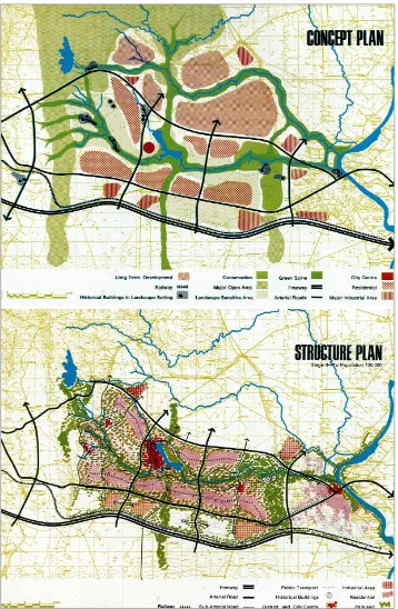
The most detailed analysis of the implications of Dunstan’s view that landscape was central to the conception of Monarto is perhaps contained in the document Monarto Planning Studies, produced by the MDC’s Town Planning Division late in 1974. It was based ‘to a large extent’ on the input by the consultants, PG Pak-Poy & Associates and Kazanski & Associates (associated with Shankland Cox Partners of London) (Figure 1).
Countering the criticism of the Monarto site for its blandness, in Monarto Planning Studies (1974) the commission sought to demonstrate a subtle complexity:
23
P A U L W A L K E R , J A N E G R A N T A N D D A V I D N I C H O L S a wide variety of landscape detail formed by complex and rugged gullies, rolling slopes, stands of native vegetation and rock outcrops (p 9).
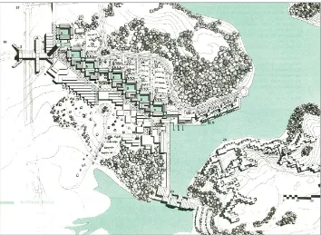
This description may overestimate the interest value of the site’s topography and vegetation cover. Yet these differentiations informed decisions about the location of the city’s major elements. The park system would be based on natural drainage channels, giving it an overall east–west orientation, with a north–south parkland spine established to produce linkages – corridors both for wildlife and human recreation. The confluence of two major creek systems, the Dry and Rocky Gully creeks, coincided with a central area, or the ‘heartland’, with mature stands of tree cover:
The vegetation in association with the two creeks and complex and varied landforms
offer the opportunity to create a central parkland of distinctive beauty which could give Monarto a uniquely Australian image (Monarto Planning Studies, 1974, p 24).
This heartland was to be the focus of Monarto’s ‘landscape concept’ and its ‘total urban structure’, the confluence of natural and built elements creating ‘a complex and intense area forming the hub of the city’ (ibid, p 26). A new lake would reinforce and complement existing attributes.
Transportation routes within the city were also aligned with the east–west pattern of the site’s natural features, complementing the existing major Adelaide– Melbourne road and rail line. The overall road pattern within the metropolitan area was a loose grid threaded with parkland corridors.
Development areas for residential neighbourhoods, the central city, industrial and service areas and institutional uses were allocated in relationship both to the projected parklands and conservation areas and to the transportation grid; employment opportunities would be spread throughout. Areas where sub-soil conditions would make building difficult were to be used for ‘broadacre’ purposes – particularly reafforestation (ibid, pp 26–29).
The environmentalism of the planned strategy for Monarto and the discursive context of its discussion reflected more than the design ethos brought by the consultants. The environmental cause gathered momentum under the Dunstan and Whitlam governments, as legislative and administrative innovations show. Assent was given to the Australian government’s Environment Protection (Impact of Proposals) Act on 17 December 1974, which required environmental factors to be considered during assessment (Draft Plan for Environmental Study, 1975, p 9). The MDC took pains not merely to conform to the new requirements but also to make its compliance apparent. The expedited timeframe for the city’s implementation – the first tranche of the new population was expected by the end of 1978 – compromised these intentions.
City centre
The environmental cause was of course not confined to government agencies or to Australia. The consultants designing the city centre brought international experience with them, and exposure to important lines of environmental inquiry that reinforced their influence on Monarto.
24
P A U L W A L K E R , J A N E G R A N T A N D D A V I D N I C H O L S
commercial and retail functions to make it a viable entity separate from Adelaide; and to keep it compact but in line with an ‘Australian way of life’. To the east of the site designated for the central city and its lake, remnant vegetation immediately offered the bushland amenity of Monarto’s conception. An anticipated 1,000 new residents were to be living there by the end of 1978, with 5,000 to 6,000 arriving annually thereafter (Monarto Planning Studies, 1974, p 63). Detailed design of the centre was expedited well beyond that of the outlying residential and industrial districts anticipated as part of the long-term plan (Monarto Development Commission Annual Report 1975–1976, p 14).
25
P A U L W A L K E R , J A N E G R A N T A N D D A V I D N I C H O L S
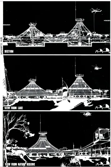
The architects involved in the design of the central city were therefore necessarily involved in the project early in its implementation and had a much wider influence on its design ethos than might otherwise have been the case. Boris Kazanski and his replacement (from early 1975) as the main architectural consultant on Monarto, John Andrews, were both Australian but both brought with them experiences and attitudes from international careers. Kazanski graduated from the University of Adelaide; before Dunstan engaged him in 1972 to work on Monarto and operate as a state urban design consultant, he had worked in Europe. There he formed associations with the Berlin architect Rolf Gutbrod, designer of the West German pavilion at Montreal’s Expo 67, and with the Rome studio of Pier Luigi Nervi, highly regarded for innovative and beautiful reinforced concrete structures. Kazanski sought to involve both Gutbrod and Nervi in the Monarto project, and Gutbrod visited the site in early 1974, to give advice based on his experience of building in the arid Middle East. Gutbrod’s Mecca Convention Centre, like his Montreal pavilion – both done with the young Frei Otto – featured dramatic tensile roofs. Kazanski’s work for the Monarto central city would focus on the ‘Monarto Hub’, a building also featuring huge, tent-like roofs. A carnivalesque centre for communal activities, the exposition of science and ‘fun’, it was apparently informed by the aleatory architectural explorations of such international 1960s neo-avant garde innovators as Cedric Price and Archigram. The Hub, first appearing in a 1974 report by Kazanski, Shankland Cox and Gutbrod, titled Concept Plan for Monarto, was not welcomed by the MDC (Figure 2).
Andrews was slightly older than Kazanski, and brought extensive experience of large, complex projects from his successful career in Canada and Australia. The architectural precedents from which his work developed stretched back to mid-century modernist debates on monumentality and urban form, to which he had been exposed during his Master of Architecture education at Harvard’s Graduate School of Design in 1957–1958. This influence is apparent in the project that made Andrews’ name as an independent architect, 1965’s Scarborough College in Toronto.
Andrews also brought significant connections to two important streams of landscape thinking. At Scarborough, he had worked with the landscape architect Michael Hough, educated at the University of Pennsylvania under Ian McHarg. McHarg’s ecological approach was to be a profoundly influential paradigm across the whole international field of landscape architecture – and regional planning – particularly after his Design with Nature was published in 1969. Hough was later characterised as one of McHarg’s most significant followers (Spirn, 2000, p 113). Whether or not it can be attributed to Hough, Scarborough indicates Andrews had a predisposition to consider building complexes in relation to landscape conditions. Certainly, by the time of Andrews’ involvement in Monarto in 1975, an environmental approach pervaded his Australian office: a report from that year on planning for the Palm Beach peninsula, for example, cites Design with Nature directly and indirectly.
26
P A U L W A L K E R , J A N E G R A N T A N D D A V I D N I C H O L S
had made a close friendship with the landscape architect Richard (Dick) Strong when both were working in the architectural office of JB Parkin, a leading Toronto practice that had sought to remake itself as a ‘modern’ company with work akin to that of Mies van der Rohe. Andrews and Strong were to work separately from the same building in Colborne Street in central Toronto; both were part of an informal collective of professionals called Integ. Strong, like Andrews, had studied at Harvard, but his teacher, leading landscape architect Hideo Sasaki, was more conventional than McHarg and continued to see landscape architecture primarily as a modernist, aesthetic enterprise. (On Sasaki as a teacher, see Necker and Tunnard, 1993; and as a landscape architect, see Walker, 1993.) Strong
27
P A U L W A L K E R , J A N E G R A N T A N D D A V I D N I C H O L S
worked in Sasaki’s Boston area office (Simo, 2001) and, later, Strong’s own firm in Toronto had a partnership with Sasaki for some time. Strong followed Andrews to Australia to work on the Cameron Offices project, designing landscapes for the long courtyards between the complex’s seven fingers, themed to represent different Australian landscapes. Period photographs of these gardens suggest Sasaki’s formalism remained entrenched in Strong’s approach.
Additionally, Andrews’ personal charisma and the fame he enjoyed in the mid-1970s gave his views particular bearing. Andrews’ rather schematic work for central Monarto (Figure 3) shows evidence of both the formalism of Strong’s landscape approach and McHarg’s environmentalism, the growing paradigm of the period. The first can be seen in the diagonal axis that bisects the plan, and in the cascade of pools – each square in the plan – around which Andrews configured the main central city buildings. The second can be found in the environmentalism that marks the broader Andrews approach, stated right at the beginning of his first report for the MDC, Potentials for Monarto: First Impressions (1975), co-written with Philip Cox. The authors wrote that Monarto ‘presents an excellent opportunity to demonstrate prototypical environmental planning and design … The problems are typical … but containing various ecological systems whose conservation would be an asset to any city’.
Planting the city
During 1975, as planning proceeded, research into environmental conditions of the site accelerated. A Draft Plan for Environmental Study issued in January 1975 lists 12 areas in which ‘base-line’ studies of existing conditions at Monarto either were already being undertaken by independent consultants or experts from the South Australian Museum, universities and other research organisations or were about to be commissioned. These 12 areas (none complete) were: aquatic environment, botany, climatology, ecology, geology, geomorphology, historic