Along the shoreline and in the sea where limestone is in contact with the sea water marine erosion and weathering processes produced beautiful and unique seascape features such as sea-stack, sea-arch, sea-cave, sea-notch, promontory, remnant island, abrasion platform and magnificent rare mangrove forest growing on limestone bedrock. This phenomenon forms beautiful and unique scenery between limestone hills.
Apart from landscape features, limestone is also rich in fossils and other geological elements of high scientific value. Several fossil and mineralisation sites have been identified in Kilim-Kisap and Dayang Bunting areas.
IMPORTANCE OF GEOHERITAGE IN LANDUSE PLANNING AND THE NEED FOR CONSERVATION
As discussed above the geological heritage features at each geosite have taken hundred million years to be produced through very slow geological processes. A feature like the oldest piece of tronjehmite rock is found only on Pulau Tepur and should be well protected. Many other features of similar rarity and importance can be found in Langkawi and must be included in the list of national heritage. The sea-karst and island karst features are very rare and similar landscape can only be found in a few places in the whole world. The majestic Machinchang landscape is only found in the Machinchang range. These evidences tell us that they are priceless and should remain intact or with minimum disturbance in future.
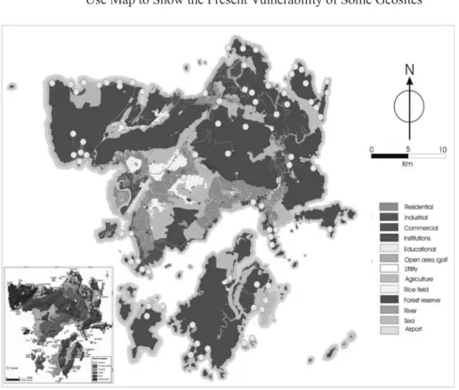
FIGURE 5 : Distribution of Geoheritage Sites Superimposed on the Present Land Use Map to Show the Present Vulnerability of Some Geosites
Another approach to conservation is via the introduction of geological monuments and protected sites (Ibrahim Komoo and Kaderi Md Desa 2003; Komoo 2003). Geological monument is defined as a large site with several important geoheritage resources and outstanding landscapes. Two of the four geological monuments of Langkawi are related to limestone geoheritage and the other two are associated with the clastic sedimentary rock. They are Pulau Langgun and Pulau Singa Kechil Geological Monuments. Pulau Langgun is made of Setul limestone and protected within Kilim Karst Geoforest Park, while Pulau Singa Kechil bears Chuping limestone and is protected under the Protected Forest Reserve. Conservation strategy for other geoheritage sites located outside of the Forestry Department jurisdiction is still in its early planning stage.
and can be regarded as national treasures and heritages. These geoheritage features are also non-renewable, which means that once they are damaged or wiped out they will be gone forever. These reasons justify that most of the geoheritage resources and geosites need to be urgently protected or at least given due consideration in the land use planning to ensure their sustainability. At present most of the geoheritage features identified at more than 90 geosites in Langkawi are located either in the three geoforest parks or Permanent Forest Reserve, but the rest remain vulnerable because they are not located in any conservation area (Figure 5) and can be easily wiped out for development (Tanot Unjah 2011). Realising this possibility the Malaysian Geological Heritage Group of Malaysia has submitted about 15 of the highly critical and most important geosites to the Heritage Department of Malaysia to be listed as national heritage.
Geoheritage conservation efforts under the geoforest park concept are not only very important to science but can also ensure the sustainability of geotourism activities in Langkawi Geopark. All the three geoforest parks have now become main tourism areas due to their rich natural attractions provided by the unique geosites combined with rich biological resources. In Kilim Karst Geoforest Park, tourists are coming in large numbers to experience the boat trail and to enjoy the beautiful scenery created by the combination of limestone karst landscape, mangrove forest and geosites found along this trail. For Dayang Bunting Marble Geoforest Park, the main attractions are its freshwater lake, the Pregnant Maiden island landscape and other beautiful smaller islands within the park. In reality the beautiful karst landscapes which were formed by geological processes over a very long period of time is actually the main attraction in these areas. Whilst in the Machinchang geoforest park the mountain landscape is already very majestic and magnificent even without other features. In reality Machinchang Geoforest Park hides so many highly valuable resources including the primary and sedimentary structures as well as beautiful ones of the oldest shallow marine sequence in this region. This aspect however was not known to many people before they have the basic geological knowledge to enable them to appreciate the importance of the geological features and factors in these scenic areas. While cruising along on the way to Dayang Bunting tourists can stop at several geosites in the Singa formations scattered on the several smaller islands.
TABLE 2 : Number of Tourist Arrival in Kilim Area, 2006-2009
RANKING THE GEOSITE FOR CONSERVATION
As had been shown all the geological heritage features and sites in Langkawi are very important. Those features and sites, which are very significant at the global or regional level need urgent protection. How they can be protected is another subject for discussion. At the same time there are quite a number of other features that look very similar and fall in the same category. Hence, a method to rank each feature or geosite is very important not only for it significance, but also for the purpose of management and protection. First and foremost all geosites in Langkawi need to be categorised accordingly such as based on rock type, mineralogy, fossil, geological structure, landscape, geological process, etc. Then the ranking processes can be done within the category, for instance, if there are five geosites that fall in the same category, each of them should be ranked to indicate exactly which geosite or feature is the most important and should be urgently protected by whatever means and the rest may be sacrificed for the sake of development. In order to do this a chart (Figure 6) is proposed and can be used as a guide to rank the geosites or stand alone geological features. This chart is a subjective assessment of the geosites based on the significance and the usage of the geosites. If a geosites is very important to science at the global level it carries the highest rank and so on as shown in the figure. Based on this which geosite is the most important and should be protected without
YEAR TOURIST ARRIVAL
AT KILIM
2006
(Langkawi Geopark was declared as national 42,375 geopark in May 2006)
2007
(Langkawi Geopark was declared as a 78,145 member of Global Geoparks Network in
June 2007)
2008 167,142
2009 115,660
(up to September)
FIGURE 6 : Chart Showing the Significance Versus the Usage of a Geoheritage Site or Feature That Can Be Used as a Guide in Ranking It.
CONCLUSION
the first global geopark in Southeast Asia. This would not have been possible if not because of continuous research programmes that had unveiled the geological secrets of Langkawi and tireless public awareness programmes and promotion of the unique and internationally significant geological features found there. Even at this stage there is no guarantee that all the geological features found at more than 90 geosites will be sustained for over a long period of time. Rapid physical development and the needs for space might one day wipe out some of the most important geosites. These geosites are the main attractions in geo-eco-tourism for now and also in future. Protecting these geosites mean that protecting the future of Langkawi’s tourism industry. To ensure the sustainability of geo-ecotourism industry these geosites need to be given due consideration in future land use planning. This consideration for land use planning would also mean a better-integrated city plan. For this purpose each geosite needs to be accurately zoned and protected or at least put under a management body that will look after its promotion and future development.
REFERENCES
Bignell, J. D. and Snelling, N. J. 1977. Geochronology of Malayan Granites. Overseas Geology and Mineral Resource, 47, 1-72.
Che Aziz Ali, Kamal Roslan Mohamed, Ibrahim Abdullah and Mohd Shafeea leman. 2005. Mikrofasies dan Diagenesis di dalam Batu Kapur Formasi Setul di Kawasan Sekitar Kilim, Langkawi (trans. Microfacies and Diagenesis in Limestone Formations Around Kilim, Langkawi). In Lembangan Kilim [trans. Kilim Basin]. Mohd Shafeea Leman, Ibrahim Komoo, A. Latif and Hood Salleh, eds. Penerbit LESTARI, UKM. 171-183.
Che Aziz Ali, Kamal Roslan Mohamed and Ibrahim Abdullah. 2003. Formasi Setul Langkawi: Geologi dan Sumber Warisan (trans. Setul Formation of Langkawi: Geology and Heritage Resources). In Warisan Geologi Malaysia (trans. Geological Heritage of Malaysia). Ibrahim Komoo and Che Aziz Al, eds. Penerbit LESTARI UKM. 89-117.
Cocks, L. R. M., Fortey, R. A. and Lee, C. P. 2005. A Review of Lower and Middle Palaeozoic Biostratigraphy in West Peninsular Malaysia and Southern Thailand in its Context within Sibumasu Terrane. Journal of Asian Earth Sciences, 24(6), 703-717.
Harun, Z., Jasin, B. and Mohamed, K. R. 1999. Paras Laut Holosen di Pulau Tanjung Dendang: Satu Warisan Geologi Malaysia (trans. Holosen Sea Level at Pulau Tanjung Dendang: A Malaysian Geological Heritage). In Geological Heritage of Malaysia – Conservation Geology for Geotope Development. Komoo, I. and Leman, M.S., eds. Lestari UKM Publication, Bangi. 133-143.
Ibrahim Abdullah, Kamal Roslan Mohamed and Che Aziz Ali. 2003 (a). Geologi Formasi Machinchang [trans. Machinchang Geological Formation]. In Warisan Geologi Malaysia [trans. Geological Heritage of Malaysia]. Ibrahim Komoo and Che Aziz Ali, eds. Penerbit LESTARI UKM. 71-87.
Ibrahim Abdullah. 2003 (b). Evolusi Struktur Kepulauan Langkawi [trans. Structural Evolution of the Langkawi Archipelago]. In Warisan Geologi Malaysia (trans. Geological Heritage of Malaysia). Ibrahim Komoo and Che Aziz Ali, eds. Penerbit LESTARI UKM. 201-215.
Ibrahim Komoo and Syafrina Ismail. 2003. Pentas Hakisan Laut Pulau ular [trans. Erosion Stage of Pulau Ular]. In Warisan Geologi Malaysia (trans. Geological Heritage of Malaysia). Ibrahim Komoo and Che Aziz Ali, eds. Penerbit LESTARI UKM. 345-365.
Ibrahim Komoo and Kaderi Md Desa. 2003. Kepulauan Langkawi: Bahan Geologi dan Landskap Sebagai Sumber Pembangunan Pelancongan (trans. Langkawi Archipelago: Geology and Landscape Materials as a Resource for Tourism Development). In Warisan Geologi Malaysia (trans. Geological Heritage of Malaysia). Ibrahim Komoo and Che Aziz Ali, eds. Penerbit LESTARI UKM. 3-12. Ibrahim Komoo. 2003. Geologi Pemuliharaan Kepulauan Langkawi [trans. Geological
Conservation of Langkawi Archipelago]. Dlm Ibrahim Komoo and Che Aziz Ali, eds. In Warisan Geologi Malaysia (trans. Geological Heritage of Malaysia). Penerbit LESTARI UKM. 13-34.
Ibrahim komoo and Tanot Unjah. 2003. Fitur Mirip Perlarutan pada Batuan Granit di Tanjung Burau, Langkawi [trans. Dissolution-like Features on Granite Rock at Tanjung Burau, Langkawi]. In Warisan Geologi Malaysia [trans. Geological Heritage of Malaysia]. Mohd Shafeea Leman, Che Aziz Ali and Ibrahim Komoo, eds. Penerbit LESTARI. 99-110.
Ibrahim Komoo and Syafrina Ismail. 2001. The Abrasional Platforms of Pulau Ular, Langkawi Islands, Kedah. In Geological Heritage of Malaysia-Geoheritage Mapping and Geosite Characterization. Ibrahim Komoo, Tjia, H. D. and Mohd Shafeea Leman. eds. Bangi: LESTARI, Universiti Kebangsaan Malaysia. 163-186.
Ismail, S. M., Komoo, I. and Leman, M. S., Mohamed, K. R., Ali, C. A., Ahmad, N. and A. Latiff. eds. 2005. Geoforest Parks - Hanging Garden of Langkawi. Forestry Dept Peninsular Malaysia and Lestari UKM, Kuala Lumpur.
James Bachat, Joy Jacqueline Pereira and Ibrahim Komoo. 2007. Pembangunan Kerangka Konsep Kemudah-terancaman untuk Geobencana. Malaysia (trans. Development of Vulnerability Concept Framework for Geohazard). Journal of Environmental Management, 8, 39-56.
Joint Nature Conservation Committee (JNCC). 2002. The Geological Conservation Review (GCR) at http://www.jncc.gov.uk/gcr/gcrweb/thegcr.htm 29/08/2002 [ 1June]
Jones, C. R. 1981. Geology and Mineral Resources of Perlis, North Kedah and the Langkawi Islands. Geological Survey Malaysia District Memoir, 17, 257.
Jones, C. R. 1961. A Revision of the Stratigraphical Sequence of the Langkawi Islands, Federation of Malaya. Proc. Ninth Pacific Science Congress, volume 12, 287-300. Joy. J. Pereira. 2003. Physical Characteristics of Beaches on the Island of Langkawi.
Wan Fuad Wan Hassan. 2003. Batuan Igneus Kepulauan Langkawi [Trans. Igneous Rocks of Langkawi Archipelago]. Dlm Warisan Geologi Malaysia [Trans. In Geological Heritage of Malaysia]. Ibrahim Komoo and Che Aziz Ali, eds. Penerbit LESTARI UKM. 255-269.
Juhari Mat Akhir. 2003. Geomorphologi Pulau Dayang Bunting, Pulau Tuba dan pulau Singa Besar [Trans. Geomorfology of Pulau Dayang Bunting, Pulau Tuba and pulau Singa Besar]. Dlm Warisan Geologi Malaysia [Trans. In Geological Heritage of Malaysia]. Ibrahim Komoo and Che Aziz Ali, eds. Penerbit LESTARI UKM. 323-332.
Juhari Mat Akhir. 2003. Fitur Geomorpfologi menarik di Timur Kepulauan Langkawi (trans. Interesting Geomorphology Features in East Langkawi Archipelago). In Warisan Geologi (trans. Geological Heritage of Malaysia). Ibrahim Komoo and Che Aziz Ali, eds. Penerbit LESTARI UKM. 333-343.
Kamal Roslan Mohamed. 2003. Sejarah Perkembangan Bumi Langkawi (trans. Historical Development of Langkawi). In Warisan Geologi Malaysia (trans. Geological Heritage of Malaysia). Ibrahim Komoo and Che Aziz Ali, eds. Penerbit LESTARI UKM. 183-200.
Komoo, I. 2003. Conservation Geology – Protecting Hidden Treasure of Malaysia. ASM Inaugural Lectures 2003. Academi Sains Malaysia and Lestari Publications, Bangi. 51.
Lee, C.P. 2006. The Cambrian of Malaysia. Palaeoworld, 15, 242-255.
Mohd Shafeea Leman. 2003. Fosil Dalam Formasi Machinchang (trans. Fossil in Machinchang Formation). In Warisan Geologi Malaysia (trans. Geological Heritage of Malaysia). Ibrahim Komoo and Che Aziz Ali, eds. Penerbit LESTARI UKM. 219-231.
Leman, M. S. 2000. Langkawi Dropstones: Outstanding Glaciogenic Sedimentological Features in Malaysia. In Geological Heritage of Malaysia – Resource Development for Conservation and Nature Tourism. Komoo, I. and Tjia, H.D., eds. Lestari UKM Publication, Bangi. 59-82.
Leman, M. S. 2003 (a). An Early Permian (Early Sakmarian) Brachiopod Fauna from the Sungai Itau Quarry and its Relationship to other Early Permian Brachiopod Horizons in Langkawi, Malaysia. Geological Society of Malaysia Bulletin, 46, 155-160. Leman, M. S. 2003(b). Batu Kapur Berusia Perm di Kepulauan Langkawi (trans. Perm-
aged Limestone on Langkawi Archipelago). In Geological Heritage of Langkawi. Ibrahim Komoo and Che Aziz Ali. eds. Lestari UKM and LADA Publications, Bangi. 155-170.
Leman, M. S., Ali, C. A. and Mohamed, K. R. 2005. Palaeobiodiversity of Pulau Langgun, Langkawi, Malaysia. In Culture and Nature Heritage of Langkawi – Kilim Basin. Leman, M. S., Komoo, I., A. Latiff and Salleh, H. M., eds. Lestari UKM Publication, Bangi. 157-169.
Narimah Samat. 2010. Assessing Land Use Land Cover Changes in Langkawi Island: Towards Sustainable Urban Living. Malaysian Journal of Environmental Management, 11 (1),48-57. ISSN 1511-7855.
Nur Fazzillah Muhamed Noordin, Alias Abdullah and Muhammad Nur Azraei Shahbudin. 2007. Multicriteria Analysis of Flood Causes in Kuala Lumpur. Journal of the Malaysian Institute of Planners, 5, 17- 42.
Pereira, J. J. and Komoo, I. 1999. Sustainable Management of the Physical Component of the Urban Ecosystems: the Malaysian perspective. In Integrating City Planning And Environmental Improvement: Practicable Strategies For Sustainable Urban Development. Miller, D. and Roo, D. G., eds. Aldershort: Ashgate.
Prosser, C. Murphy, M. and Larwood, J. 2006. Geological Conservation- a guide to good practice. Peterborough. English Nature.
Shi, G. R., Leman, M. S. and Tan, B. K. 1997. Early Permian Brachiopods of Gondwanan Affinity from the Singa Formation, Langkawi Islands, Northwestern Peninsular Malaysia. Proceedings of the International Conference on Stratigraphy and Tectonic Evolution of Southeast Asia and the South Pacific, Bangkok. 62-72.
Stauffer, P. H. and Mantajit, N. 1981. Late Palaeozoic Tilloid of Malaya, Thailand and Burma. In Earth’s Pre-Pleistocene Glacial Records. Hambrey, M.J. and Harland, W.B., eds. Cambridge University Press. 331-337.
Syafrina Ismail, Ibrahim Komoo and Joy. J. Pereira. 2003. Warisan Pantai Langkawi: Kajian Kes Pasir Tengkorak dan Pantai Teluk Baru (trans. Langkawi Beach Heritage: A Case Study of Pasir Tengkorak and Pantai Teluk Baru) In Warisan Geologi Malaysia (trans. Geological Heritage of Malaysia). Ibrahim Komoo and Che Aziz Ali, eds. Penerbit LESTARI UKM. 367 -378.
Tanot Unjah. 2011 Characterisation and Assessment of Geoheritage Resources for the Development of Langkawi Geoparks Component. Unpublished Doctor of Philosophy Thesis. Malaysia: National University of Malaysia.
Tanot Unjah. 2009. Status Terkini Sumber Warisan Geologi di Langkawi (trans. Current Status of Geological Heritage Resources in Langkawi). In Siri Pembangunan Penyelidikan Kelestarian - Menjana Keilmuaan Kelestarian (trans. Sustainability Research Development Series - Generating Sustainability of Knowledge). Saiful Arif Abdullah and Adnan A. Hezri, eds. Bangi: LEASTARI, UKM, 153-171. Wan Fuad Wan Hassan. 2003 (a). Warisan Mineral Kepulauan Langkawi (trans. Minerals
Heritage of Langkawi Archipelago). In Warisan Geologi Malaysia (trans. Geological Heritage of Malaysia). Ibrahim Komoo and Che Aziz Ali, eds. Bangi: Penerbit LESTARI UKM. 233-242.
Wan Fuad Wan Hassan. 2003 (b). Pasir Hitam di Kepulauan Langkawi (trans. Black Sand of Langkawi Archipelago) In Warisan Geologi Malaysia (trans. Geological Heritage of Malaysia). Ibrahim Komoo and Che Aziz Ali, eds. Penerbit LESTARI UKM. 243-253.
Wan Fuad Wan Hassan. 2003. Batuan Igneus Kepulauan Langkawi (trans. Igneous Rock of Langkawi Archipelago). In Warisan Geologi Malaysia (trans. Geological Heritage of Malaysia). Ibrahim Komoo and Che Aziz Ali, eds. Penerbit LESTARI UKM. 171-182.
Zaiton Harun, Basir Jasin and Kamal Roslan Mohamed. 2003 (a). Paras Laut Holosen di Pulau Tanjung Dendang: Satu Warisan Geologi Malaysia (trans. Holosen Sea Level at Pulau Tanjung Dendang: A Geological Heritage of Malaysia). In Warisan Geologi Malaysia (trans. Geological Heritage of Malaysia). Ibrahim Komoo and Che Aziz Ali, eds. Penerbit LESTARI UKM. 271-280.
Zaiton Harun, Basir Jasin and Kamal Roslan Mohamed. 2003 (b). Tasik Laut Kuno: Satu Warisan Tabii Langkawi (trans. Ancient Sea Lake: A Natural Heritage of Langkawi). In Warisan Geologi Malaysia (trans. Geological Heritage of Malaysia). Ibrahim Komoo and Che Aziz Ali, eds. Penerbit LESTARI UKM. 281-290.
LAND USE PLANNING STATUTES FOR LANGKAWI
GEOPARK CONSERVATION AND DEVELOPMENT
Sarah Aziz1, Halimaton Saadiah Hashim2 and Tanot Unjah3 Institute for Environment and Development (LESTARI)
UNIVERSITI KEBANGSAAN MALAYSIA
Rahimah Abdul Aziz4 and Chan K. L. Geraldine5 School of Social, Development and Environmental Studies
Faculty of Social Sciences and Humanities UNIVERSITI KEBANGSAAN MALAYSIA
Abstract
This paper takes off from the point that geoparks and land are intertwined, and that land use planning can serve as a means to enable effective conservation and development of geoparks. The focus lies on how existing land use related statutes could be put to use to capture the components and elements that make up a geopark, particularly in the case of Langkawi Geopark. Given that there are more than 120 statutes that can be linked to the various aspects and components that make up a geopark, this article has taken the liberty to only focus on a few statutes rather than all that has been identified. This is intentional so as to enable detailed discussion regarding where components that make up a geopark can converge in land use planning aspects, also about processes and procedures that are embodied in existing statutes.
Keywords: Langkawi Geopark, law, statutes, land, land use planning
___________________________________
1Fellow, Institute for Environment and Development (LESTARI), Universiti Kebangsaan Malaysia, 43600 Bangi, Selangor, Malaysia. e-mail: [email protected]
2Guest Editor, Principal Fellow, Institute for Environment and Development (LESTARI), Universiti Kebangsaan Malaysia 43600 Bangi, Selangor, Malaysia. e-mail: [email protected]
3Fellow, Institute for Environment and Development (LESTARI), Universiti Kebangsaan Malaysia, 43600 Bangi. Email: [email protected]
4Guest Editors, Professor,School of Social, Development and Environmental Studies, Faculty of Social Sciences and Humanities, Universiti Kebangsaan Malaysia, 43600 Bangi, Selangor, Malaysia. e-mail: [email protected]
INTRODUCTION
This article will begin by setting out the use of terms for the following key words, i.e., law, conservation, development and geopark, so as to facilitate a focused discussion that would lead towards determining options that can make law work for geopark conservation and development focusing on land use planning. This is essential as what is meant by the different terms and how they are used are diverse, and differ from one discipline to another. Here the terms used are contextualised, using the broadest sense of the word, so as to fit the many disciplines and interpretations available. A brief note is also about how statutes are chosen and matched with prerequisites in ensuring that conservation and development can be both made complementary, through existing regulatory mechanisms.
Without going into a protracted debate as to what is meant by law, or what is the concept of law, the ‘law’ as discussed here is taken in its simplest form, as being a set of rules set in statutes (written law as opposed to oral, customary law or judicial precedents) which are instruments of governmental power (Morrison 1997). It focuses purely on the systems and sets of rules that manifest or can be manifested through statutes of law, which controls human behaviours and actions. Laws are useful means to help establish mandates, jurisdiction, standards, procedures, processes and rules, as well as determine the scope of responsibility and accountability (Sarah Aziz et al. 2002). The emphasis is on the rules and regulations needed to effect conservation and development in a geopark setting, pinned to the fact that what constitutes on geopark and the focus areas of a geopark are predominantly related to land and how land is used.
Development, for the purpose of discussion will be taken to mean that which advances growth and fosters improvement of as well as for human wellbeing. Given that this article is slanted towards conservation and development in a geopark setting, it will be guided by what the WCED (1987) offers in terms of ‘development’:
“… The word “development” has also been narrowed by some into a very limited focus, along the lines of “what poor nations should do to become richer,” and thus again is automatically dismissed by many in the international arena as being a concern of specialists, of those involved in questions of “development assistance.” But the “environment” is where we live; and “development” is what we all do in attempting to improve our lot within that abode.”
What is meant by geopark, is taken from the concept mooted by the Global Geopark Network (GGN) that grounded the designation of an area with clearly defined boundaries and a large enough area for it to serve local economic and cultural development (particularly through tourism) (GGN April 2010). An area designated as a geopark would be made up of a geographical area where geological heritage sites are part of a holistic concept of protection, education and sustainable development, that facilitates the synergy between geodiversity, biodiversity and culture, highlighting sites of ecological, archaeological, historical and cultural value (GGN April 2010).
The proposed context for the use of terms as put forward earlier, would serve to structure and guide the discussion regarding the role played and can be played by statutory law. The discussion will focus on the link between existing statutory provisions, the prerequisites for geopark conservation and development and land use planning. This article borrows from the arguments advanced by Moroni (2010), in that social-spatial order can exist only if it has been deliberately thought out and constructed, in this case, an order in which the system of rules and order of actions will match up. He further quotes Patrick Abercrombiei, who states, “… planning occurs when mankind…makes a definite and conscious attempt to model or mould his environment …”. This is the point of departure, in that how can statutes be used to help better mould human behaviour in a geopark setting.
GEOPARK CONSERVATION AND DEVELOPMENT: BUILDING BLOCKS FOR CONSIDERATION
Taking each aspect, fundamental questions will have to be set out to aid identification of statutes and statutory provisions available and options required to ensure that the four aspects are addressed. From the research undertaken on Langkawi Geopark Governance and Langkawi Geopark Management Plan funded by Universiti Kebangsaan Malaysia (UKM) research grant and Langkawi Development Authority (LADA) respectively, it was determined that a statutory profile is necessary to enable clearer understanding of what mandates are available in so far as managing a geopark is concerned. In addition, both studies also set out to detail the various required mandates to govern Langkawi as a geopark. This necessitated the breaking down of the component that constitutes and serves as the key focus of a geopark. In this article, the exercise is referred to as identification of geopark building block.
The main focus of the statutory profiling component and mandate identification, was finding out the true sense of any form of words (Singh 2004) therein a statute. In order to do that, the keywords intended to be sought need to be identified first, then an approach is adopted to aid profiling, focused on the purpose of the statute, or purposive approach which is the favoured approach here in Malaysia, as expounded by the Interpretation Act 1948 (revised 1967), section 17A, which states that in the interpretation of a provision of an Act, a construction that would promote the purpose or object underlying the Act (whether that purpose or object is expressly stated in the Act or not) shall be referred to as a construction that would not promote that purpose or object. From this exercise more than 120 statutes were identified based on the key aspects of what constitutes and can be linked to a geopark. For the purpose of this article, the examples shared herein, focus on the key aspects of geopark, conservation and development, which will later be used to establish the link between law and land use planning.
An essential requirement under the GGN guidelines for inclusion of an area as a geopark under the list (GGN 2010) is the determination of a clear boundary and area pegged to protection, education and sustainable development. From a statutory perspective this brings forth three fundamental questions:
• Which governmental entity has the mandate to determine the boundary and area? • Which statutory provision provides the processes and procedures required to
establish such boundary and area?
• How can the law be used to make sure that aspects of geological, biological and cultural heritage and diversity are ‘captured’ when a boundary is determined?
The second aspect touches on the designated authority or partnership of authority to conserve and develop a geopark. Statutory law figures heavily here, as it serves as the basis for which mandates can be set out and the identification of jurisdiction of specific components that make up a geopark. Essentially, geopark conservation and development can be divided into two parts: the components or ‘things’ that make up a geopark, and the activities that can be directly or indirectly linked to a geopark, including the ensuing impact (positive and negative). Taking this simplistic point of view, the identification of government authority and relevant statutory provisions can be divided into these two sectors to aid preliminary profiling of the ‘who’s’ and ‘what’s’.
The components ‘sustainable tourism’ and ‘sustainable economic development’ are not as easily determined, given that there is a wealth of literature on the subject matter. The United Nations Environmental Programme and World Tourism Organisation, in their Making Tourism More Sustainable: A Guide for Policy Makers (2005), provides some insight as to what sustainable tourism could mean:
“…Sustainable tourism is not a discrete or special form of tourism. Rather, all forms of tourism should strive to be more sustainable…Making tourism more sustainable is not just about controlling and managing the negative impacts of the industry. Tourism is in a very special position to benefit local communities, economically and socially, and to raise awareness and support for conservation of the environment. Within the tourism sector, economic development and environmental protection should not be seen as opposing forces - they should be pursued hand in hand as aspirations that can and should be mutually reinforcing…It must be clear that the term ‘sustainable tourism’ - meaning ‘tourism that is based on the principles of sustainable development’ - refers to a fundamental objective: to make all tourism more sustainable. The term should be used to refer to a condition of tourism, not a type of tourism…”
Drawing from this, it would seem that the law should focus on ensuring that conditions are in place to ensure that tourism activities are sustainable, based on principles of sustainable development. The laws should be structured to facilitate tourism activities that benefit local activities and environment, in this case local communities and geopark components in Langkawi.
through the enhancement and promotion of a certain image related to the geological heritage and the development of tourism with related actions that have a direct impact on the territory influencing its inhabitants’ living conditions and environment (McKeever et al. 2005). It should also take into consideration the sustainable resource utilisation, provision of infrastructure and local socio-economic development (Sharina Abdul Halim et al. 2011). The essential consideration here would be how the law could be used to structure provisions that would enable the fostering of local economic activities that in turn would serve both human and environmental well being.
The fourth building block to be considered is the conservation and development of the geological, biological and cultural heritage and area. This trigonal dimension, interlinking biodiversity, geology and culture adds further challenge, in that each aspect will have to be broken down then regrouped based on commonalities. The term biodiversity, as defined in the United Nations Convention on Biological Diversity 1992, literally blankets the biological kingdom and its ecological processes, which covers a wide variety of plants, animals and microorganisms as well as ecosystems. The Millennium Ecosystems Assessment Report (2005), also refers to it as being a multi-dimensional term that also includes the complexity and interdependency of living organisms and humans, forming the foundation of ecosystems services to which human beings are intimately linked ; a layer of living organisms through the collective metabolic activities of its innumerable plants, animals and microbes physically and chemically unites the atmosphere, geosphere and hydrosphere into one environmental system, which is the manifestation of the workings of life.
This would mean, in so far as conservation and development had been simplified in context, biodiversity offers a three-layered focus area. The first encompasses the living and complex organisms, which include humans, plants, animals and microbes. The second layer looks at habitat and ecosystems, while the third layer looks at ecological services. What would be of primary consideration is the various species that make up the biodiversity family, including the sub-species; the areas, habitats and ecosystems where these species reside (focus being on non-human species); and lastly, the components of ecological services. In Malaysia, the term biodiversity is contextualised in the National Biodiversity Policy 1998 as encompassing three levels, genetic diversity (within species, measured by variations within genes of individual plants, animals and microorganisms, both within and between populations of species), species diversity and ecosystem diversity (this covers habitats, biotic communities and ecological processes in the terrestrial, marine and other aquatic environment).
Consideration will also have to be made regarding whether the act of conservation and development is conducted in situ or ex situ, as the means to regulate would then vary. Geodiversity (Gray 2008), is the abiotic equivalent to biodiversity, and includes the natural range of geological (rocks, minerals and fossils), geomorphological (land form and processes) and soil features, which also include their assemblages, relationships, properties, interpretation and systems. Gray also breaks them down into four categories, features, processes, sites and specimens. With regard conservation, Sharples (1993) offers a perspective worth considering in that, geoconservation aims at conserving the diversity of the Earth features and systems and allowing the ongoing processes to continue to function and evolve in a natural fashion. Gray (2008) also cites the principle upheld in the Australian Natural Heritage Charter 1996 (updated in 2002), which states that conservation is based on respect for biodiversity and geodiversity, and should involve the least possible physical intervention to ecological processes, evolutionary processes and Earth processes. Almost similar to biodiversity, the focus would also be on ‘who’ and ‘what’ can be used to regulate matters pertaining to the conservation and development of features, processes, sites and specimens.
Without going through the debates on what constitutes culture, this article will look at what culture means based on the definition given by Edward Burnett Tylor in his book Primitive Culture (1871) (in Jokilehto 2005).:
“Culture ... is that complex whole which includes knowledge, belief, art, morals, law, custom, and any other capabilities and habits acquired by man as a member of society.”
outstanding universal value from the point of view of science, conservation or natural beauty).
In Malaysia, the National Heritage Act 2005 (NHA 2005) interprets natural heritage to include any features of any area in Malaysia, which may consist of earthly physical or biological formations or groups of such formations, geological or physiographical features, mountains, streams, rock formation, sea shore or any natural site of outstanding value from the point of view of nature, science, history conservation or natural beauty including flora and fauna. The NHA 2005 further interprets cultural heritage to include tangible and intangible forms of cultural property, structure or artefacts and may include heritage matter, object, item, artefact, formation structure, performance, dance, song, music that is pertinent to the historical or contemporary Malaysians’ way of life, on or in land or underwater cultural heritage or tangible form but excluding natural heritage.
What is prevalent here, is that there is a need to identify, from the present statutory regime, who and what can be used to determine a heritage, what would be the criteria used, and what should be done should a ‘heritage’ is identified or determined. This is critical to ensure that such interpretation, definition or contextualisation is adopted for usage by all parties concerned, and reflected either through a legal instrument such as a statute, rule or regulation or through accepted practices, either through administrative orders or circulars. It is also important to take into account that the NHA 2005 on heritage refers to national heritage, not local heritage.
The cursory deconstruction of what constitute the building blocks that make up a geopark is crucial. This is to enable the profiling of the ‘statutory needs’ to facilitate the conservation and development of a geopark. The main intent of establishing a geopark, is for the protection of and to highlight the geological heritage, within the synergistic relationship of biodiversity, geodiversity and cultural heritage. It should also provide for education on the environment, training and development of scientific research in the various disciplines, enhancement of the natural environment and sustainable development policies (Eder et al. 2004). If biological, geological and cultural heritage are put together, perhaps the aims raised for geological heritage (Sharples 1995) could be used as a guide, as it would be pinned to aspects, which are of significant value to the people so long as their intrinsic values are not decreased, be it for purposes of education; scientific research; aesthetics and inspiration; recreation; cultural identification and development as well as a sense of contribution to a sense of place as experienced by people.
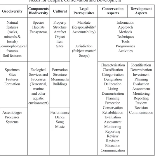
processes and procedures. Guided by the discussion above, Table 1 links biodiversity, geodiversity and cultural heritage components with the key aspects for consideration in geopark conservation and development, particularly when reviewing current statutory regime. The items listed in the conservation and development aspects columns have been drawn from the literature listed in the Reference section of this article.
TABLE 1 : Factors for Consideration when Reviewing and Determining Statutory Needs for Geopark Conservation and Development
From a legal point of view, using the land use approach can help address the points for consideration raised for each building block identified. The emphasis then would be on the need to balance the use of land, and the control of land use. More importantly the
Components Legal Conservation Development
Geodiversity Biodiversity Cultural Prerequisites Aspects Aspects Natural Species Property Mandate Information features Habitats Structure (Responsibility/ Approach (rocks, Ecosystems Artefact Accountability) Methods minerals & Object Techniques
fossils) Item Tools
Geomorphological Sites Jurisdiction Programmes features (Subject matter/ Activities Soil features Scope)
Characterisation Identification Specimen Ecological Formation Classification Determination
Sites Services and Structure Categorisation Investment Features Processes Monuments Designation Planning Formation (Terrestrial, Buildings Delineation Evaluation marine Listing Assessment and other Demonstration Monitoring
aquatic Planning Reporting environment) Protection Review
Conservation Revision
Assemblages Performance Rehabilitation Communication Processes Dance Evaluation
Systems Song Assessment
Music Monitoring Reporting
planning of how it should be used becomes the primary point of departure. Considerations will have to be made regarding what is on the land (the materials and sites of interest and significance); what is the condition, state and status of the land; what are the existing and planned activities on the land; what are the development directions (as evident in policies); and what are the existing regulatory measures in place. What is important is how land use planning measures are to be used to control, restrict and permit activities within a designated geopark. For that the following must be made clear:
• The aspects to be conserved (sites, specimens, materials, etc.);
• The types of activities that will have to be controlled, restricted and permitted; • The key threats and impacts to the site, specimen, material, etc. as well as actions to
be undertaken to address them;
• Competing and conflicting interests in relation to the land, site or material or specimen on or in the location that has been identified for either conservation or development; and
• Land status, with special focus on rights to land or site or material or specimen etc., and the scope to modify or restrict or vary such right accorded to the owner or occupier.
AUTHORITY OVER AND IN RELATION TO LANGKAWI GEOPARK
Langkawi archipelago, has been declared a geopark, and has undergone its first assessment in June 2011. In the earlier mentioned series of studies on Langkawi Geopark Governance and formulation of a Langkawi Geopark Management Plan, it was noted from the exercise conducted in profiling the statutes that can be linked to the geopark, the one aspect that came through was the need to determine the appropriate mandates and means to link the different mandate holders to ensure that the governance structure and system for Langkawi Geopark is made clear. This would then contribute to a partnership setting where authority is concerned (as recommended by the GGN guidelines), as Malaysia adopts a federated system of government guided by the provisions of the Federal Constitution of Malaysia 1957. This simply means that in Langkawi, there is three tiered government system in place, i.e. Federal government, State government and Local Authorities. Each level of government is represented by their respective agencies or designated authority, drawing their mandates form existing legislative provisions.