GROUND TRUTHING GREENING THROUGH GIS: A MICROSTUDY OF SOIL AND WATER CONSERVATION IN BURKINA FASO
By Sarah Benecky
Honors Thesis
Department of Anthropology
TABLE OF CONTENTS
1. Sahelian Greening and Research Questions ... 5
Introduction... 5
The Sahel... 6
Research Questions ...6
Methods... 7
Desertification of the Sahel... 8
Greening of the Sahel... 10
Challenging the Received Wisdom ... 10
Burkina Faso ... 12
Overview of chapters ... 16
2. Discussion of Methodology ... 17
Review of Traditional Methods ... 17
Description of Methodology ... 23
3. Discussion of Observed Trends in SWC and Tree Cover ... 31
Results and Analysis... 31
List of Figures
Figure 1... 5
Figure 2 ... 14
Figure 3 ... 15
Figure 4 ... 20
Figure 5. ... 21
Figure 6 ...22
Figure 7 ... 24
Figure 8 ... 25
Figure 9 ... 26
Figure 10...27
Figure 11...28
Figure 12 ... 29
Figure 13...32
List of Tables Table 1 ... 30
Table 2 ... 31
ACKNOWLEDGEMENTS
Firstly, I would like to thank Cassy Karlson and Bella Reiss for their work in digitizing various aspects of the satellite imagery used. Analysis would not have been possible without the data produced from the meticulous digitization of both trees and dams. Also, my deep
CHAPTER 1
SAHELIAN GREENING AND RESEARCH QUESTIONS
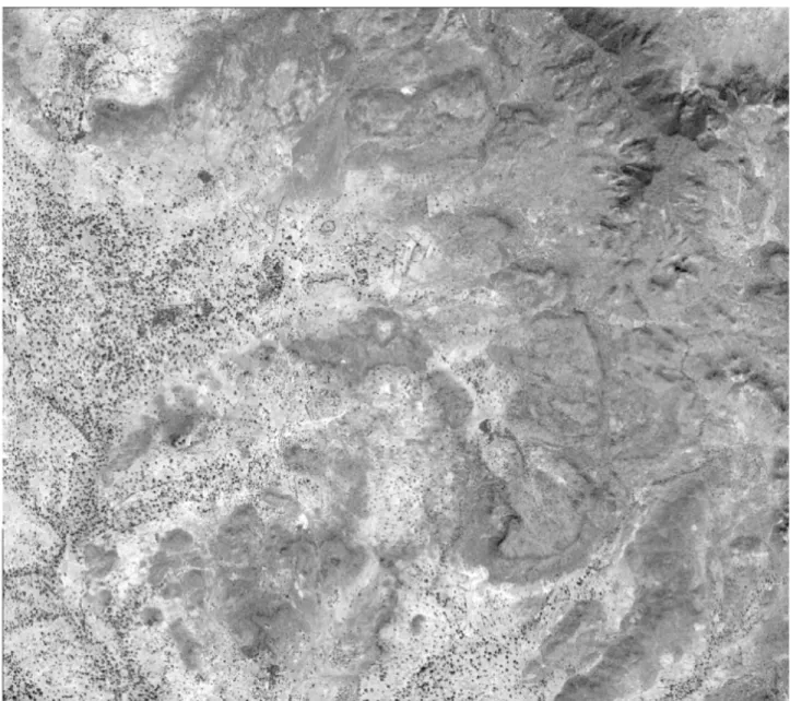
Figure 1. Satellite Image of the department of Kongoussi in Burkina Faso from Google Maps
Introduction
work by farmers may not be evident in Figure 1, what are the implications of using high-resolution satellite imagery for comprehensive spatial analysis at the ground level?
The Sahel
The Sahel region of Africa is a semi-arid climatic zone situated at the southern border of the Sahara Desert. In fact, “sahel” is derived from the Arabic word for ‘shore,’ as it is situated at the edge of the immense desert expanse. Frequent droughts are a natural phenomenon in the Sahel, often resulting in famine and distress migration (MA 2005). Fluctuating climatic and rainfall patterns also drove much of the regional land cover changes and vegetation reduction in the 1970s and 1980s. However, anthropogenic factors such as overgrazing, mono-cropping, and other unsustainable methods on the land have also played a role (MA 2005). Despite the
ubiquitous challenges presented by the unpredictable Sahelian environment, the ecosystem exists dynamically, and changes constantly (Herrmann et al. 2005). The methods of analysis for
studying anthropogenic and ecological responses to environmental degradation ultimately transform how the Sahelian landscape is understood and acted upon. While the regeneration of vegetation, or “greening,” of the Sahel has been well-documented, the underlying causal processes remain ambiguous.
Research Questions
foundational to greening are poorly understood from the local-level, emphasizing the necessity of examination through high-resolution satellite imagery.
In order to understand the impact of local conservation efforts in the broader process of greening, I examine: what is the spatial relationship between tree cover and SWC in northern Burkina Faso in the villages Sakou, Loulouka, and Kouka? To begin investigating this question, I also ask: how is high-resolution satellite imagery effective in evaluating greening on a local scale? What are the advantages, as well as the shortcomings, of GIS methods in studying greening? How does the methodology utilized in this thesis inform future work surrounding greening in the Sahel and a broader understanding of the Sahelian environment?
Building upon a human ecology framework and the models laid out by Leach and Mearns (1996), the analysis recognizes that broad environmental processes such as greening must
consider the role of smallholders. The management and adaptation techniques of subsistence farmers within this dynamic semi-arid ecosystem remain critical to understanding larger processes.
Methods
intersection of these feature classes provided data to test the hypothesis: tree cover will be greater among areas treated by Soil and Water Conservation projects. A more in-depth
exploration into methodology concerning GIS and environmental studies of the Sahel region will be offered in the following section. Spatial analysis also included tables to examine frequency, in addition to graphs and tables that display the results.
Desertification of the Sahel
The Sahel region of Africa is frequently associated with environmental degradation, more specifically, desertification (West et al. 2017). The term gained traction following the 1975 study of the Sahel by J.G. Charney. Charney hypothesized that overgrazing in the Sahel region was degrading vegetation and land productivity, ultimately resulting in desertification (1975). According to this study, degradation led to a self-perpetuating process of increasing ground albedo and less solar radiation absorption, resulting in desertification (Charney 1975). Subsequently, the image of an exploited environment marked by widespread desertification manifested itself in public perception of the region. As a result, skewed perceptions inform the work done by non-governmental organizations (NGOs), those offering international aid, as well as broader policy decisions by regional governments (Leach and Mearns 1996). As defined by the U.N. Convention to Combat Desertification, desertification refers to “land degradation in arid, semi-arid and dry sub-humid areas resulting from various factors, including climatic variations and human activities.” (MA 2005:5) More generally, land degradation can be understood as any decrease in overall productivity of a dryland.
study based on ground and aerial observations of northern Sudan, in which he concluded that the Sahara Desert boundary was rapidly expanding southwards, threatening the productivity of the bordering land (Swift 1996). Ibrahim outlined similar assumptions through his geographical work in northern Darfur, concluding that desertification was largely human-induced through unsustainable practices (Ibrahim 1984:17). While drought was understood as a fairly common occurrence in the Sahel due to the highly variable patterns of rainfall, it was not acknowledged as the main source of desertification (Swift 1996). Prominent studies of the time understood the main impacts of desertification as human-induced, involving decreasing land productivity, deforestation, and expanding sand dunes (Swift 1996:79). These initial views became ingrained in the global community. Experts in the fields of geography and ecology and organizations interested in international development such as the UN used this analysis to inform their work. Ultimately, establishing a dominant narrative that set the foundation for future action in the region.
Greening of the Sahel
Satellite imagery in which the Normalized Difference Vegetation Index (NDVI) was measured over the course of 1982 to 1999 implies that a reversal of desertification has been occurring in some parts of the Sahel (Olsson et. al 2005). The term greening commonly refers to the process of increased revegetation in the Sahel region. Comparing annual rainfall data with NDVI patterns indicated a correlation between the two variables; Olsson et. al recognized that an increase in rainfall could not alone account for the increases in vegetation (2005:563). A
particular source of issue comes from the relatively coarse 8-km spatial resolution utilized for the measurements of NDVI. Coarse resolution presents a great challenge when trying to pinpoint an exact location to compare rainfall, especially considering the inconsistency of rainfall in a semi-arid environment (Olsson et. al 2005). In addition, changing practices in land use and
management, as well as demographic and migratory shifts, may contribute to the fluctuations in land cover. Greening is a complex and dynamic process influencing a range of social and environmental factors. Thus, further studies which encompass a variety of perspectives and disciplines are necessary for a more complete understanding of the mechanisms behind greening (Olsson et. al 2005).
Challenging the Received Wisdom
Mearns 1996:5). The prevailing international narrative essentially dismissed all accounts of the land by local people. However, the practices of the local people’s response to environmental changes and role in resource management proved to be highly prudent. Despite the “received wisdom” often being taken for granted, through an interdisciplinary approach that considers a historical, ecological, and anthropological analysis, a re-imagination of the narrative attached to the African landscape becomes possible. In their seminal text focusing on deforestation, Fairhead and Leach (1996) look at the case study of Kissidougou, Guinea in West Africa. The study offered an alternative to the broadly accepted narrative that deforestation in the area ensued as a result of uncontrolled slash and burn agriculture by the local people. By utilizing a combination of aerial photographs (satellite imagery) and ethnographic ground-truthing (information gathered by direct observation and interviews, on location), Fairhead and Leach revealed the reality of the landscape. Patterns of central villages were in-fact surrounded by mosaics of forest, ultimately demonstrating reforestation. Their theoretical framework utilizing traditionally anthropological and ecological methodologies questioned the efficacy of traditional ways the African landscape has been analyzed. The human ecological framework laid out by Fairhead and Leach combines both the activities of local actors and satellite, setting the foundation for this thesis work.
remains unclear as it extends beyond the conventional desertification framework, warranting further study.
Burkina Faso
My thesis work was primarily focused in northern Burkina Faso, an environment that historically endured environmental degradation from exploitation of the central resources such as forests and fields (Sawadogo 2011). In order to combat the significant environmental stresses characteristic of the Sahel, local farmers within the region instituted a variety of initiatives involving Soil and Water Conservation. Through a series of long-term field studies involving rural participatory appraisal, or conversing with local farmers about perceived environmental changes, remote sensing of satellite images, and statistical data on crop yields, rainfall, etc., Reij et. al (2005) demonstrated the evolving role of SWC in the central plateau of Burkina Faso. Sawadogo (2011) too conducted a prominent study in which agronomic surveys of various villages demonstrated the impact that SWC projects present in northern Burkina Faso had in improving land productivity and local livelihoods (Sawadogo 2011:127).
One of the most prominent techniques of SWC used in conjunction with semi-permeable dams is contour stone bunds, known in French as diguettes (West et. al 2017). Diguettes are low and narrow rock barriers that are assembled between plots of agricultural land as a means to inhibit soil erosion (West et. al 2017) (Figure 2). Semi-permeable dams, as seen in Figure 3, are larger than diguettes, running perpendicular to gullies of washes, or areas of water drainage. The rock bunds and dams collect a range of organic deposits; an example is the entrapping of plant seeds that will eventually grow adjacent to the stone barriers (West et. al 2017, Reij et al. 2005). In a village with an agricultural-based livelihood, there often exists hundreds of diguettes
Conservation projects overall have prompted revegetation of some 100,000 hectares with
evidence of improved crop yields and soil quality (Reij et al. 2005:649, 651). While local
farmers and households experience clear small-scale benefits, the effects of SWC on the larger
Overview of chapters
CHAPTER 2
DISCUSSION OF METHODOLOGY
Review of Traditional Methods
The increasing prominence of remote sensing (RS) and geographic information science (GIS) prompted an emergence of new techniques in environmental research and studies of human-environment interaction. However, its advent presented various limitations that need be addressed. In order to establish a background of traditional GIS usage, a brief overview will be provided of the traditional methodology used to study the Sahelian environment. This leads into an overview of the shortcomings associated with GIS technology as articulated by Turner’s 2003 study of grazing management in western Niger, a part of the Sahel bordering Burkina Faso. Finally, an alternative methodology is offered that recognizes the complex, dynamic relationship between humans and their environment. Such methodology seeks to curtail past shortcomings associated with GIS and conventional studies of the Sahelian landscape.
According to Turner (2003), there are three main issues arising from traditional
environmental study of the Sahel. These issues can be understood as: spatially/temporally biased observations, isolated or singular visual descriptions, and failure to consider or attempt to
understand local-level, rural production systems (Turner 2003:258). With regard to spatially and temporally biased observations prior to satellite usage, observation relied upon travel by
individuals around the land. Consequently, observations were limited to the dry season,
factors of rainfall, soil condition, and human activity, essentially ignoring the larger systems affecting change (Turner 2003).
Perhaps the most pertinent weakness of traditional studies of the Sahel remained the lack of understanding of rural production systems at the local-level. Within the Sahel, the relationship between farmers, agro-pastoralists, pastoralists, and land is dynamic, emphasizing the need for a holistic approach to analysis. In early approaches failing to consider such complexity, circular arguments attributed sparse vegetation interchangeably to environmental degradation and human activity, ignoring the role of climatic and geographical factors all together (Turner 2003:258). With a strong dependence on visual description of patterns, scientific interpretation remained more “flexible” in the conclusions that could be drawn. Thus, political and economic objectives of nation-states and international institutions, such as the United Nations, have shaped the body of findings regarding environmental change in the Sahel. The result manifested as a lack of understanding of the human contexts and ecological mechanisms and processes underlying such changes (Turner 2003:259).
evident, as the fine-scale spatiotemporal trends typical of burning in this area of the savanna were essentially undetected by the algorithm used. In fact, the coarse imagery led to
miscalculation of burning by at least a factor of 10 (Laris 2005:419).
Consequently, the major implications of resolution biases on global analyses on land management and the study of environmental change must be addressed (Laris 2005:412). Thus, while GIS produces more complex quantitative inquiries, the predisposition of using land cover as the sole variable in assessing anthropogenic effects on land is misguided (Turner 2003:265). Approaches taking a human ecology-based perspective are ideal in this regard, where local land practices and land cover change are evaluated on the ground, at a local-scale. The integration of remote sensing and ethnographic methods facilitates exploration of the processes underlying environmental and cultural change, as well as perceptions of landscape itself (Jiang 2003). In a “mixed methods” case study of Inner Mongolia, Jiang shows how Remote Sensing (RS) provides additional insights regarding landscape change, which ethnography exclusively would not
discern. An analysis of satellite imagery complements the qualitative data offered by accounts of local actors, enhancing understanding of human–environment relationships (Jiang 2003).
However, the potential for GIS to support work within human ecology requires an increase in the resolution of the imagery used for analysis. High resolution imagery illustrates the actual
dynamic of a locality in instances of land linked to specific activities and specific actors, presenting an invaluable opportunity for future GIS work (Turner 2003:265).
experimental endeavor in human ecology using GIS and high-resolution satellite imagery as a means for “bottom-up” analysis.
Description of Methodology
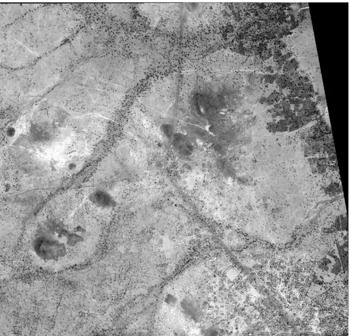
The analysis used high-resolution GeoEye-1 multispectral satellite imagery, consisting of 4-band multispectral (red, green, blue and near infrared) images in conjunction with
panchromatic images for the three villages Sakou, Kouka, and Loulouka. The images were produced by the GeoEye-1 satellite and were captured in 2014 prior to the beginning of the rainy season in Burkina Faso.
As shown in Figure 7, for each 25-km2 (5-km X 5-km) sized image, a random sampling of grid sections was applied to the raw layer of the panchromatic images, ultimately covering approximately 32% of the image. Utilizing the fishnet tool on ArcGIS 10.4, 300 90-m by 90-m grid samples were initially added as a layer over the raw image, making 900 total grids across the three villages. The sampling was entirely arbitrary; there was no specific targeting of dry or wet appearing areas of each landscape or any further analysis of elevation and proximity to water sources.
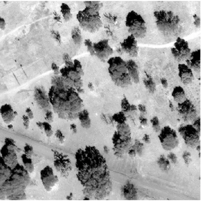
Within each of these 8100-m2 grid cells, the objective was to first conduct spatial analysis, focusing on the presence of any trees. Based within the high-resolution image, as seen in the panchromatic of Figure 10, the canopy of each tree was digitized as a polygon, followed by an approximate measurement of canopy diameter. In order to focus on mature trees,
discounting shrubs and other low-lying vegetation, a measurement tool embedded within the software allowed the diameter to be measured. A focus on more “established” trees also served as rationale for the 10-m or greater standard set as grounds for digitization of a tree. Each tree falling into the criterion of a diameter greater than 10-m and located within a grid was
correspondingly digitized through creation of polygon features (Figure 10). All tree polygon features were aggregated into a singular feature class. Similarly, the dams present in each of these three villages were digitized as polyline features, having been identified through the
To begin to examine the presence of any relationship between dams and trees, a rounded buffer was added to each dam, reflecting the range of land treated by SWC. The buffers were made 200-m in order to highlight the connection between dams; dams are intentionally constructed along washes to form a network, thus a buffer size large enough to encompass the linkages between dams needed to be selected. Rather than viewing dams in terms of isolated plots of land, the buffers were necessary to show the broader configuration and patterns of SWC at a village-scale. Additionally, diguettes surround the areas in between dams. Thus, the creation of a 200-m buffer accounted for the dams, and it approximated the surrounding diguettes. In Figure 11, the “network” produced from overlaying buffers is shown for Sakou, illustrating the contiguous, yet somewhat patchy distribution of SWC.
Figure 12. Intersection between grid cells, trees, and buffers
referencing Figure 12, these intersections are more easily visualized: the brown grids are classified as within buffers, the orange grids as outside of buffers, and the blue polygons are all trees inside of grids. The result was a data set that could be used for the initial analysis of SWC and tree cover. Figure 12 ultimately shows the clear distinction of grids inside or touching the buffer versus those lying outside.
There were ultimately four categories possible within the data set: presence of both trees and SWC, absence of both trees and SWC, presence of trees and absence of SWC, and absence of trees and presence of SWC. A combination of Union and Intersect Geoprocessing tools ultimately combined feature classes into a single layer that produced a table with these corresponding categories, as shown by Table 1.
Table 1. Categorization of grid cells
Trees
Yes No
Buffer
Yes
?
?
CHAPTER 3
DISCUSSION OF OBSERVED TRENDS IN SWC AND TREE COVER
Results and Analysis
Upon initial comparison, no obvious correlation between tree presence and SWC was apparent from the results shown in Table 2 and Figure 13. The usage of simple statistical analysis in the form of a Chi-square test attempted to test the probability of the observed distribution of trees and buffers and the degree it could be attributed to chance. Essentially, the test provided a manner to observe the distribution of data within the four categories illustrated in Table 1.
Table 2. Descriptive Statistics by Locality
Locality Total Trees Total Dams Total Trees
Inside Buffers (within grids)
Total area treated by SWC (ha)
Sakou 679 146 535 939
Kouka 198 50 55 487
Figure 13. Total number of trees and dams by locality 0
100 200 300 400 500 600 700 800
Sakou Kouka Loulouka
SWC and Tree Relationship
In this case, the null hypothesis was that there exists no relationship between tree cover and Soil and Water Conservation; therefore, wherever the observed data is incongruent with the model data, the probability that the variables are dependent is supported. For the category most pertinent to the hypothesis, presence of both trees and dams, the expected count was 99.5, with the observed being 130, showing that Soil and Water Conservation contributes to greening. As evident in Table 3, the Pearson Chi-square value is 20.144, indicating that the model fits the data. There are more trees in areas treated with SWC than would be expected based on chance alone.
Table 3. Chi-square Cross Tabulation
Trees
Yes No Total
Buffer
Yes
Observed Count
130 218 348
Expected Count
99.5 248.5
--
No
Observed Count
155 494 649
Expected Count
185.5 463.5
--
Total Count 712 285 997
Ultimately, the results supported the hypothesis that SWC is driving regeneration of vegetation at the local-level in Sakou, Kouka, and Loulouka. In focusing on the scale of these three villages, SWC improvements have contributed to increased tree cover as substantiated by the Chi-square model. Furthermore, these findings support the ethnographic “ground truthing” gathered by West et al. (2017). The increased presence of trees in areas treated by SWC supports West et. al’s account of the positive perceptions of Mossi farmers surrounding dams and
diguettes regarding SWC and vegetation regeneration.
Conclusion
Central to this work is the framework for human ecology laid out by Fairhead and Leach (1996). Their work emphasizing both ecological and sociocultural methodologies questioned the widespread belief of anthropogenic degradation in the Guinea forest-savanna. Through a novel framework integrating historical data, ethnography and satellite images, they invalidated the myth of human-induced devastation. In doing so, Fairhead and Leach highlighted how false perceptions supported power dynamics that drove unreasonable land policies in Guinea. Narrow perspectives that view vegetation solely in regard to degradation marginalize the work and methods of farmers to improve their lands. Thus, such methodologies proposed by Fairhead and Leach are vital to the frequently misunderstood impacts of greening and SWC in Burkina Faso.
Faso, the work of Mossi farmers creating semi-permeable dams as a means of Soil and Water Conservation is perceived to have transformed once degraded land; however, this cannot be fully captured by broad-sweeping analyses of greening through land-use/land-cover (LULC)
classification.
Bibliography
Charney, J. G.
1975 Dynamics of Deserts and Drought in the Sahel. Quarterly Journal of the Royal Meteorological Society 101(428): 193–202.
Fairhead, James, and Melissa Leach
1996 Misreading the African Landscape: Society and Ecology in a Forest-Savanna Mosaic. Cambridge: New York: Cambridge University Press.
Herrmann, Stefanie M., Assaf Anyamba, and Compton J. Tucker
2005 Recent Trends in Vegetation Dynamics in the African Sahel and Their Relationship to Climate. Global Environmental Change 15(4): 394–404.
Jiang, Hong
2003 Stories Remote Sensing Images Can Tell: Integrating Remote Sensing Analysis with Ethnographic Research in the Study of Cultural Landscapes. Human Ecology 31(2): 215–232.
Laris, Paul S.
2005 Spatiotemporal Problems with Detecting and Mapping Mosaic Fire Regimes with Coarse-Resolution Satellite Data in Savanna Environments. Remote Sensing of Environment 99(4): 412–424.
Leach, Melissa, and Robin Mearns
1996 The Lie of the Land: Challenging Received Wisdom on the African Environment. Oxford: Heinemann.
Millennium Ecosystem Assessment (MA)
2005 Ecosystems and Human Well-Being: Desertification Synthesis, World Resources Institute, Washington, D.C.
Olsson, L., L. Eklundh, and J. Ardö
2005 A Recent Greening of the Sahel—trends, Patterns and Potential Causes. Journal of Arid Environments 63(3): 556–566.
Reij, C., G. Tappan, and A. Belemvire
2005 Changing Land Management Practices and Vegetation on the Central Plateau of Burkina Faso (1968–2002). Journal of Arid Environments 63(3): 642-659.
Rishmawi, Khaldoun, and Stephen D. Prince
Sawadogo, Hamado
2011 Using Soil and Water Conservation Techniques to Rehabilitate Degraded Lands in Northwestern Burkina Faso. International Journal of Agricultural Sustainability; London 9(1): 120–128.
Tucker, Compton J., Harold E. Dregne, and Wilbur W. Newcomb
1991 Expansion and Contraction of the Sahara Desert from 1980 to 1990. Science 253(5017): 299–301.
Turner, Matthew D.
2003 Methodological Reflections on the Use of Remote Sensing and Geographic Information Science in Human Ecological Research. Human Ecology 31(2): 255–279.
West, Colin Thor, Aaron Moody, Elisabeth Kago Nébié, and Oumar Sanon