USER SEGMENT OF KOREAN WIDE AREA GLOBAL
NAVIGATION SATELLITE SYSTEM
SAYED CHHATTAN SHAH Assistant Professor
Department of Information Communications Engineering Hankuk University of Foreign Studies, South Korea
E-mail: [email protected]
ABSTRACT
Korean wide area differential global navigation satellite system augments global navigation satellite system by broadcasting additional signals from geostationary satellites and providing differential correction messages and integrity data for the GNSS satellites. It includes a network of wide area reference stations, wide area master station, ground earth station and geostationary satellites. Wide area reference stations are widely dispersed GNSS data collection sites that monitor and process satellite data to determine satellite orbit and clock drift plus delays caused by atmosphere and ionosphere. This information is then transmitted to wide area master station which creates and broadcasts correction messages through geostationary satellites. The user segment receives and applies correction messages to improve position accuracy and reliability. This study presents a flexible and robust software design and data processing algorithms of user segment of Korean wide area differential global navigation satellite system. The user segment software performs numerous functions such as calculation of ionosphere and troposphere delays, processing of correction messages, and data quality monitoring. It implements numerous tropospheric, ionospheric and position models, supports RINEX and BINEX data exchange formats, and is designed to work in real time and post processing modes. It can also be used in precision and non-precision approach modes. The software is divided into several layers such as Data Processing and Visualization, and can be easily extended to support various interfaces such as web interface and mobile device interface. The current version processes global positioning system and wide area differential global navigation satellite system data but can be easily extended to support various global navigation satellite systems such as GLONASS and Galileo.
Keywords: Global Navigation Satellite System, Global Positioning Systems, GPS Augmentation System
1.
INTRODUCTIONKorean wide area differential global navigation satellite system is a large scale research project funded by Ministry of Land, Transport and Maritime Affairs [1]. It augments global navigation satellite system [4] by broadcasting additional signals from geostationary satellites and providing differential correction messages and integrity data for the GNSS satellites. It includes a network of wide area reference stations, wide area master station, ground earth station and geostationary satellites. Wide area reference stations are widely dispersed GNSS data collection sites that monitor and process satellite data to determine satellite orbit and clock drift plus delays caused by atmosphere and ionosphere. This information is then transmitted to wide area master station which creates and broadcasts correction messages through
geostationary satellites. The user segment receives and applies correction messages to improve position accuracy and reliability [2].
This study presents a flexible and robust software design and data processing algorithms of user
segment of Korean wide area differential global navigation satellite system [3]. The user segment software performs numerous functions such as calculation of ionosphere and troposphere delays, processing of correction messages, and data quality monitoring. It implements numerous tropospheric, ionospheric and position models, supports RINEX and BINEX data exchange formats, and is designed to work in real time and post processing modes. It can also be used in precision and non-precision approach modes. In the precision approach mode, fast, slow, ionospheric and tropospheric corrections are applied while in the non-precision approach mode only fast and slow corrections are applied [4]. The software is divided into several layers such as Data Processing and Visualization, and can be easily extended to support various interfaces such as web interface and mobile device interface. The current version processes global positioning system and wide area differential global navigation satellite system data but can be easily extended to support various global navigation satellite systems such as GLONASS and Galileo [4].
2.
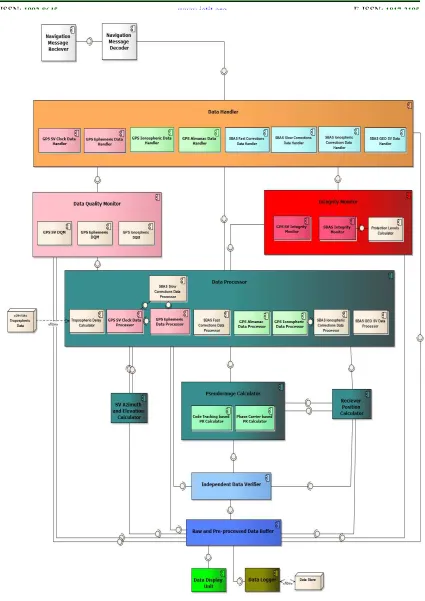
ARCHITECTURAL DESIGNArchitecture of user segment software is given in Figure 3 which shows the relationship between key components. For a detailed description, readers are referred to [5].
3.
DATA PROCESSING ALGORITHMSWide area master station broadcasts three types of correction messages through geostationary
satellites. 1) Fast Corrections for satellite clock’s rapid and short-term errors, 2) Slow Corrections for satellite clock’s slow drift errors and slow ephemeris errors, and 3) Ionospheric Grid Point Corrections for the estimated ionosphere signal propagation delays [2]. A block diagram of corrections message processing is given in Figure 4. In this section, key algorithms required to process and apply fast and slow corrections messages are described. For a detailed description of data processing algorithms, readers are referred to [6].
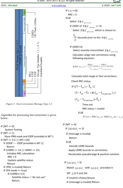
3.1 Processing of Fast Corrections
Fast corrections are used to correct fast-changing parameters such as satellite clock errors, and are included in message type 2-5 and 24. The fast corrections message contains pseudorange corrections and user differential range correction indicator. PRC is used to remove pseudorange error whereas UDREI is satellite health parameter which takes values in range of 1 to 15.
SBAS User Segment Software BINEX or RINEX File
Receiver Position Correction Data Integrity Alarms
Figure 2: User Segment Software Block Diagram
Algorithm for processing fast corrections is given below.
IF (MT == 0) System Testing IF (MT == 1)
Store PRN mask and IODP provided in MT 1 IF (MT == 2-5 || MT==24)
IF (IODP != IODP provided in MT 1) Return
IF (UDREI == 14 || UDREI == 15) Initialize RRC calculation
RRC = 0
Update satellite status Return
IF (PRC is invalid) Return IF (PA mode == true)
IF (UDREI>=12)
Satellite status = “do not use” Return
IF (aii==0)
RRC = 0 ELSE
Select
p rev io u s
P R C
IF (IODF of P R Ccurrent == 3) Select
previo u s
P R C which is closest to
fc
I
2
Seconds prior to the P R CcurrentIF (IODF<3)
Select recently transmitted P R Cp rev io u s Calculate range rate corrections using following equation:
c u r re n t p r e v i o u s o f
o f , c u r re n t o f , p re v i o u s
P R C P R C R R C ( t )
t t
− =
−
Calculate total range or fast corrections:
Check RRC status
IF ((
t t
−
of) >I
fc||(
t t
−
of−
1
) > 8(t
of−
t
of ,previous) ||(
t
of−
t
of ,previous)>I
fc)Time-out
RRC status = invalid
ELSE
o f of of
FC ( t )=P R C ( t )+R R C ( t )( t−t )
IF (MT == 6)
IF (
j
IO D F == 3) IF (message is invalid) Return
ELSE
Decode UDRE bounds
Apply UDRE bounds to corrections
Recalculate pseudorange & position solution
IF ( j
I O D F < 3)
Match j
I O D F with I O D Fjprovided in
MT
j
(2-5 and 24) [image:3.595.85.515.96.755.2]IF (match==False) Return IF (message is invalid) Return
ELSE
Decode UDRE bounds
Apply UDRE bounds to corrections provided in
MT
j
Recalculate pseudorange and position solution
IF (MT == 7)
IF (IODP != IODP provided in MT 1) Return
ELSE
[image:4.595.82.504.71.682.2]Store the UDRE degradation and Time-out intervals
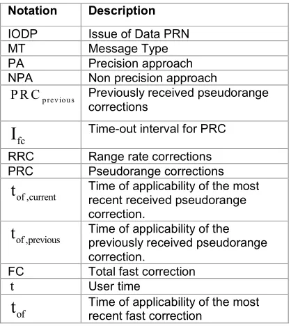
Table 1: Notations used in algorithm
Notation Description
IODP Issue of Data PRN
MT Message Type
PA Precision approach
NPA Non precision approach
p rev io u s
P R C Previously received pseudorange corrections
fc
I
Time-out interval for PRCRRC Range rate corrections
PRC Pseudorange corrections
of ,current
t
Time of applicability of the mostrecent received pseudorange correction.
of ,previous
t
Time of applicability of thepreviously received pseudorange correction.
FC Total fast correction
t User time
of
t
Time of applicability of the most recent fast correction3.2 Application of Fast and Slow Corrections
Fast corrections are used to correct fast-changing parameters whereas slow or long term corrections are used to provide error estimates for slow varying satellite ephemeris and clock errors, and are included in message type 24 and 25 [7]. The slow corrections message contains satellite position corrections, velocity corrections and satellite clock corrections. Message type 25 may be broadcast in two forms as per requirement. The Figure 6 shows
[image:4.595.82.291.326.560.2]The algorithm for application of correction messages is given below.
Check Integrity IF (UDREI==15) Satellite = unhealthy
IF (UDREI==14 ||
DGNSS data == invalid || IOD! =IODE)
Satellite = unmonitored
IF (PA mode == true)
IF (UDREI in MT 2-5 & 24 >= 12) Satellite Status = Do not use IF (PA mode==true)
IF (Correction message is missed &
Previously received correction data == valid)
Apply degradation models
Apply fast, ionospheric, tropospheric and clock corrections:
PR=PRmeasured+FC−ICSBAS+TCSBAS+CC
Apply long term corrections:
corrected GPS
corrected GPS
corrected GPS
x
x
x
y
y
y
z
z
z
δ
=
+ δ
δ
IF (Correction messages are not missed & fast, slow, ionospheric & tropospheric corrections are available)
Apply fast, ionospheric, tropospheric and clock corrections:
PR=PRmeasured+FC−ICSBAS+TCSBAS+CC
Apply long term corrections:
corrected GPS
corrected GPS
corrected GPS
x
x
x
y
y
y
z
z
z
δ
=
+ δ
δ
ELSE
PA not possible Exit
IF (NPA mode == true)
IF (Fast and slow corrections are available) Apply fast corrections:
m e a s u r e d
P R = P R + F C +C C
Apply slow corrections:
corrected GPS
corrected GPS
corrected GPS
x
x
x
y
y
y
z
z
z
δ
=
+ δ
δ
IF (DGPS iono corrections are available) Apply DGPS ionospheric corrections:
m e a s u re d S B A S
P R = P R + F C−IC +C C ELSE IF (GPS iono corrections available) Apply GPS ionospheric corrections:
measured GPS
PR=PR +FC IC− +CC
ELSE
Do not apply ionospheric corrections
IF (DGPS tropo corrections are available) Apply DGPS tropospheric corrections:
measured SBAS SBAS
PR PR= +FC IC− +TC +CC ELSE
Do not apply tropo corrections ELSE
Do not use the satellite
3.3 Calculation of Pseudorange Residual
Pseudorange residual implies the remaining error obtained after eliminating errors such as satellite clock bias, ionospheric delay, tropospheric delay, and clock error from the smoothed pseudorange of satellite j. An algorithm to calculate pseudorange residual is given below.
a) Calculate Distance between Reference Station and Satellite j
2 2 2
j j j j
D
=
(x x )
−
+
(y y )
−
+
(z z )
−
(x, y, z)
Reference Station Coordinatesj j j
(x , y , z )
Satellite j Coordinates,Satellite ephemeris error is included
b) Calculate Pseudorange
j j iono tropo sv p
PR
=
D
+
d
+
d
− ∆
t
+ +
B e
p
c) Smooth Pseudorange
Pseudorange , of satellite j is available from the navigation message.
Smoothed pseudorange is obtained by
K: Averaging smoothing constant, K=300
k: Epoch
d) Calculate Pseudorange Residuals
j j j io n o tro p o sv
P R R =S P R −D −d −d + ∆t −B
4.
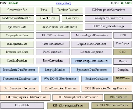
CLASS DIAGRAMSClass diagram is used to model the static view of a system. It includes classes, their attributes, operations and relationships with other classes [8]. Rectangles are used to represent classes.
.
The most important classes of user segment software of Korean wide area differential global navigation satellite system are shown in Figure 7. The classes are divided into five groups, each represented with a different color. The classes in light green color are used to represent raw and preprocessed data whereas classes in light purple color are used to represent fast and slow corrections data. Classes in sky blue and orange colors are data processing classes that are used to process raw global positioning system data and wide area differential global navigation satellite system correction messages, respectively. The classes in tan color are used to parse RINEX navigation and observation files and BINEX files. For a detailed description of each class, readers are referred to [5].
5.
SOFTWARE MODULESUser Segment software provides an interface to access numerous modules in real time and post processing modes. The key modules of user segment software are briefly described below.
Data Handlers
Data Handlers are used to hold raw and pre-processed data during the execution. Some classes such as RawPre-proccssedDataBuffer, GlobalData and Time are used to buffer raw and preprocessed data for further processing and provide utility functions to convert between time standards and coordinate systems.
Data Processor
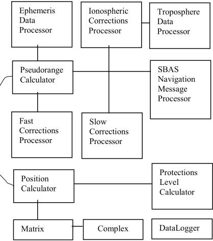
Data Processor is used to process raw data. The raw data is accessed from data handler classes and after processing either is made available to user interface classes for display or transmitted across the network. Numerous tropospheric, ionospheric and position models are implemented in this module. The diagram of data processing classes is given in Figure 8.
Matrix Complex DataLogger Ephemeris
Data Processor
Fast Corrections Processor
Slow Corrections Processor Ionospheric Corrections Processor
Pseudorange Calculator
SBAS Navigation Message Processor
Protections Level Calculator Position
Calculator
[image:6.595.302.511.447.683.2]Troposphere Data Processor
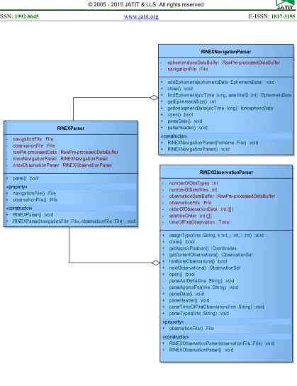
RINEX Parser
RINEX Parser is used to parse RINEX navigation and observation files. It includes two key classes: RINEXNavigationParser which is used to parse navigation files and RINEXObservationParser which is used to parse observation files. Both classes are accessed through RINEXParser class which provides an interface to rest of the components in the system. It can be used in real time or post processing mode. The class diagram of RINEX Parser is given in Figure 9.
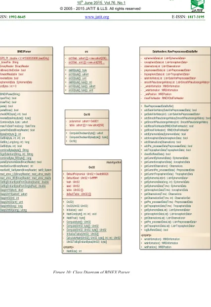
BINEX Parser
BINEX Parser provides an interface to parse BINEX files [10] in real time or post processing modes. It is designed to support:
Record 0x01 = 1 for GNSS navigation information
Record 0x7f Subrecord 0x05 for GNSS Observables
[image:7.595.309.513.286.399.2]The class diagram of BINEX Parser is given in Figure 10.
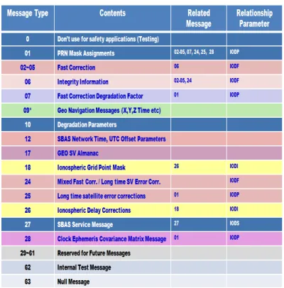
Correction Messages Parser
[image:7.595.88.288.507.710.2]Correction Messages Parser module is used to parse wide area differential global navigation satellite system’s correction messages broadcast by geostationary satellites in a binary format. A list of correction messages is given below.
Table 2: A list of correction messages
User Interface
User interface module provides an access to user segment and allow user to visualize, monitor and analyze system’s performance. It includes several screens that are used to display raw and preprocessed data and numerous static and dynamic graphs related to raw and preprocessed data. Key user interface elements are described below.
User Segment Software Screen given in Figure 11 allows user to launch software either in real time processing mode or post processing mode.
User Segment Software Real Time Processing Mode screen given in Figure 12 allows user to use various components of User Segment software in real time processing mode.
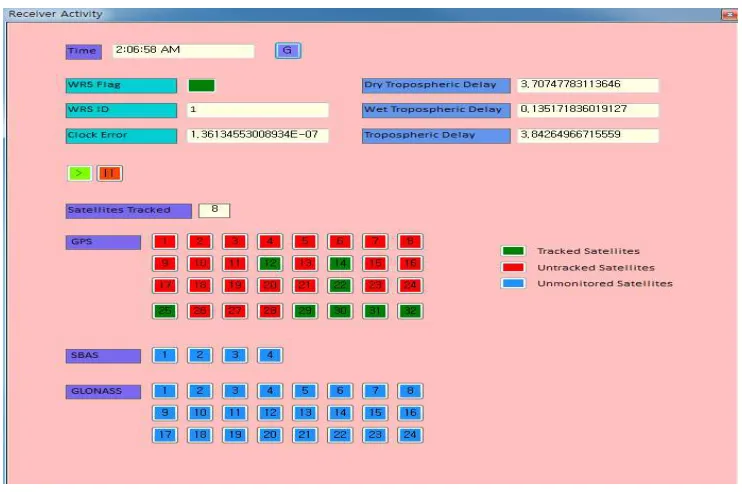
Receiver Activity Screen given in Figure 13 is used in a real time processing mode to display several important items to help user to understand how the receiver is being used and its current operating conditions.
6.
SOFTWARE CHARACTERISTICSUser Segment software of Korean wide area differential global navigation satellite system is made of several independent and reusable modules that can be modified and tested separately. The modules can be easily added or replaced into user segment software. The current version processes global positioning system and wide area differential global navigation satellite system data but can be easily extended to support various global navigation satellite systems such as GLONASS and Galileo.
7.
CONCLUSIONThe user segment software performs numerous functions such as calculation of ionosphere and troposphere delays, processing of correction messages, and data quality monitoring. It is made of several independent and reusable modules that can be modified and tested separately.
In this study a detailed design of user segment software of Korean wide area differential global navigation satellite system is described in terms of UML architectural and class diagrams. The study also describes key algorithms for processing correction messages and key user interface elements.
ACKNOWLEDGEMENT
This research paper was supported by Hankuk University of Foreign Studies Research Fund of 2015.
REFRENCES:
[1] Yun, H., C.D. Kee and D.Y. Kim, 2011. Availability performance analysis of Korean wide area differential GNSS test bed. J Korea Navigation Inst., Vol. 15, pp. 510-516.
[2] FAA Document, 1999. Specification of the Wide Area Augmentation System (WAAS). Report No. FAA-E-2892B, April 1999.
[3] Grewal, M.S., L.R. Weill and A.P. Andrews, 2007. Global Positioning Systems, Inertial Navigation and Integration. 2nd Edition, John Wiley and Sons, New York, ISBN: 9780470099711, Pages: 416.
[4] Blanch, J., T. Walter, P. Enge, S. Wallner and F.A. Fernandez et al., 2013. Critical elements for a multi constellation advanced RAIM. Navigation, Vol. 60, pp. 53-69.
[5] Shah S.C., Choi W.S., Han W.Y., Yun H., Kee C., 2013. Korean WA-DGNSS User Segment Design. TransNav, Vol. 7, No. 1, pp. 69-74. [6] Shah S.C., W.S. Choi and W.Y. Han, 2012.
Detailed design of Korean WA-DGNSS user segment software. Report No. 6060-2012-042, Electronics and Telecommunications Research Institute.
[7] RTCA SC-159, 2001. Minimum operational performance standards for global positioning system and wide area augmentation system airborne equipment, RTCA/DO-229C. November 28, 2001, Washington, DC.
[8] Tegarden, D.P., A. Dennis and B.H. Wixom, 2012. Systems Analysis and Design with UML. 4th Edition, Wiley, New York, ISBN: 9781118092361, Pages: 592.
Figure 9: Class Diagram of RINEX Parser
RINEXParser
- navigationFile :File - observationFile :File
- rawPre-processedData :RawPre-processedDataBuffer - rinexNavigationParser :RINEXNavigationParser - rinexObservationParser :RINEXObservationParser
+ parse() :bool
«property»
+ navigationFile() :File + observationFile() :File
«constructor» + RINEXParser() :void
+ RINEXParser(navigationFile :File, observationFile :File) :void
RINEXNav igationParser
- ephemerisIonoDataBuffer :RawPre-processedDataBuffer - navigationFile :File
+ addEphemeris(ephemerisData :EphemerisData) :void + close() :void
+ findEphemeris(utcTime :long, satelliteID :int) :EphemerisData + getEphemerisSize() :int
+ getIonosphericData(utcTime :long) :IonosphericData + open() :bool
+ parseData() :void + parseHeader() :void
«constructor»
+ RINEXNavigationParser(fileName :File) :void + RINEXNavigationParser() :void
RINEXObserv ationParser
- numberOfObsTypes :int - numberOfSatellites :int
- observationDataBuffer :RawPre-processedDataBuffer - observationFile :File
- orderOfObservationData :int ([]) - satelliteOrder :int ([]) - timeOfFirstObservation :Time
+ assignType(line :String, k :int, j :int, i :int) :void + close() :bool
+ getApproxPosition() :Coordinates + getCurrentObservations() :ObservationSet + hasMoreObservations() :bool
+ nextObservations() :ObservationSet + open() :bool
- parseAntDelta(line :String) :void - parseApproxPos(line :String) :void + parseData() :void
+ parseHeader() :void
+ parseTimeOfFirstObservation(line :String) :void + parseTypes(line :String) :void
«property»
+ observationFile() :File
«constructor»
Figure 10: Class Diagram of BINEX Parser BINEXParser
+ GPS_PI :double = 3.1415926535898 {readOnly} - _binexFile :String
- binaryReader :BinaryReader - isBinexLittleEndian :bool - forwardReadable :bool - reverseBytes :bool - ephemerisData :EphemerisData - crcBytes :int = 0
+ BINEXParser(String) + openFile() :bool + closeFile() :bool + parse() :bool + parseBinex() :bool + checkCRC(byte[], int) :bool + reverseByteArray(byte[]) :byte[] + Combine(byte, byte) :ushort + msecToDateTime(long) :DateTime + parseObsData(BinaryReader) :bool - Bytes2Int(byte []) :int - GetBits(byte, int, int) :int - GetBits_Long(long, int) :long - GetBit(byte, int) :bool + combineBytes(byte[]) :String + SignExtention(String, int) :String + combineBytes_BE(byte[]) :long + parseEphemerisData(BinaryReader) :bool + readSatCount(BinaryReader) :int
- readSatID_SatSystem(BinaryReader) :satID_System + read_ubnxi_LE(BinaryReader) :read_ubnxi_results + read_ubnxi_BE(BinaryReader) :read_ubnxi_results + GetBigEndianBytesFromDouble(double) :double + GetBigEndianBytesFromSingle(float) :double + SwapInt16(short) :short
+ SwapUInt16(ushort) :ushort + SwapInt32(int) :int + SwapUInt32(uint) :uint + SwapInt64(long) :long + SwapUInt64(ulong) :ulong
Crc16
- polynomial :ushort = 0xA001 - table :ushort ([]) = new ushort[256]
+ ComputeChecksum(byte[]) :ushort + ComputeChecksumBytes(byte[]) :byte[] + Crc16()
HashAlgorithm Crc32
+ DefaultPolynomial :UInt32 = 0xedb88320 + DefaultSeed :UInt32 = 0xffffffff - hash :UInt32
- seed :UInt32 - table :UInt32 ([]) - defaultTable :UInt32 ([])
+ Crc32() + Crc32(UInt32, UInt32) + Initialize() :void # HashCore(byte[], int, int) :void # HashFinal() :byte[] + Compute(byte[]) :UInt32 + Compute(UInt32, byte[]) :UInt32 + Compute(UInt32, UInt32, byte[]) :UInt32 - InitializeTable(UInt32) :UInt32[]
- CalculateHash(UInt32[], UInt32, byte[], int, int) :UInt32 - UInt32ToBigEndianBytes(UInt32) :byte[] «property»
+ HashSize() :int crc
- crc16tab :ushort ([]) = new ushort[256]... - crc32tab :uint ([]) = new uint[256] ...
+ cks08(byte[]) :byte + crc16(byte[]) :ushort + crc32(byte[]) :uint + cks08(byte[], byte[]) :int + crc16(byte[], byte[]) :ushort + crc32(byte[], byte[]) :uint
DataHandlers::RawPreprocessedDataBuffer
- ephemerisDataList :List<EphemerisData> - ionosphericDataList :List<IonosphericData> - observationsList :List<Observations> - preprocessedDataList :List<PreprocessedData> - troposphericDataList :List<TroposphericData> - satelliteHistoryList :List<SatellitePreprocessedData> - smoothPseudorangeHistoryList :List<SmoothPseudorangeHistory> - _wmsInformation :WMSInformation
- _wrsInformation :WRSInformation - _wrsPosition :WRSPosition - rinexFileHeader :RINEXObsFileHeader
+ RawPreprocessedDataBuffer()
+ addSatelliteHistory(SatellitePreprocessedData) :bool + getSatelliteHistory(int) :List<SatellitePreprocessedData> + addSmoothPseudorangeHistory(SmoothPseudorangeHistory) :bool + getSmoothPseudorangeHistory(int) :SmoothPseudorangeHistory + addRinexFileHeader(RINEXObsFileHeader) :void + getRinexFileHeader() :RINEXObsFileHeader + addEphemerisData(EphemerisData) :bool + addIonosphericData(IonosphericData) :bool + addObservations(Observations) :bool + addPre_processedData(PreprocessedData) :bool + addTroposphericData(TroposphericData) :bool + cleanBufferedData() :bool
+ getCurrentEphemerisData() :EphemerisData + getCurrentIonosphericData() :IonosphericData + getCurrentObservation() :Observations + getCurrentPre_processedData() :PreprocessedData + getCurrentTroposphericData() :TroposphericData + getEphemerisList(int) :List<EphemerisData> + getEphemerisData(long, int) :EphemerisData + getEphemerisData(Time) :EphemerisData + getIonosphericData(Time) :IonosphericData + getObservations(Time) :Observations + getObservationSet(Time, int) :ObservationSet + getPre_processedData(Time) :PreprocessedData + getTroposphericData(Time) :TroposphericData + getEphemerisDataList() :List<EphemerisData> + getIonosphericDataList() :List<IonosphericData> + getObservationsList() :List<Observations> + getPre_processedDataList() :List<PreprocessedData> + getTroposphericDataList() :List<TroposphericData> + logBufferedData() :bool
«property»
Figure 12: User Segment Software Real Time Processing Mode Screen
[image:13.595.110.481.489.735.2]