Corina Sas
Computing Department, Lancaster University, Lancaster, LA1 4YR, UK
Abstract. This study proposes a user model of navigation in a Vir-tual Environment (VE), based on investigating the differences in move-ment patterns. Two methodologies enable accessing navigational rules and strategies employed by different groups of users: high versus low spatial users. These captured rules are summarised and hierarchically or-ganised in a coherent structure which constitutes a basis for an efficient model of navigation. Implications of this model for designing navigable VEs are discussed.
1
Introduction
The need for understanding human spatial behaviour in both real and virtual worlds has been largely acknowledged. This is due to the prevalence and signifi-cance of this specific behaviour and to the high psychological distress associated with its failure.
The apparent gap between theoretical models of navigation and the design of VEs stems from limited interest in user modelling and insufficient accommo-dation of individual differences which impact on navigation. This gap impedes proper exploitation of current navigational models and theories of spatial cog-nition. This paper presents part of the work carried out for addressing this deficiency in the research literature. Therefore, consideration has been given to user model of navigation emerging from navigational rules employed by users.
The study of mental model of navigation, and of spatial behaviour which it supports, provides both theoretical and practical benefits. Such study could increase our understanding in the area of spatial cognition by validating or re-fining the current theories and models of navigation. Understanding user mental models enables also fruitful applications. Thus, some of the aspects embedded in user mental model can be formalised and used for running simulation of user behaviour. Once aspects of the user mental model have been embedded in sys-tem design, they can be used to increase user’s understanding of how the syssys-tem works, or in other words to assist users in the training process for learning to use the system.
and schematic version of the former, encapsulates some rules and strategies which high spatial users or good navigators employ successfully in their navigation. Making these rules available to low spatial users could stay at the core of training. This paper starts by introducing the concept of spatial mental models and their acquisition. A prototypical instantiation of these representations is cap-tured by the construct of cognitive maps, whose features are briefly described. The subsequent section presents the study design, in terms of procedure, ap-paratus and sample. The following section focuses on user model of navigation, initially described in terms of low and high level navigational rules. These rules represent previous findings which are only summarised in this paper, without the description of the methodology for capturing them. The next section hierarchi-cally integrates the identified rules into an efficient model of user navigation. The benefits of this model for designing VEs able to provide navigation assistance to low spatial users are discussed.
2
Spatial Mental Models
User modelling is a growing discipline in the field of Human Computer Interac-tion (HCI), extending itself in various areas which focus on the development of user adaptive systems. The major reason for this resides in the fact that these systems are and will continue to be used by heterogeneous user populations.
The distinction betweenuser mental model and user model has been often drawn in HCI literature [2, 5, 14, 17]. The user mental model is developed by users during their interaction with the system, while a user model consists of knowledge that the system holds about user’s mental model in order to improve the interaction [4].
The only way a system can adapt to successfully accommodate different groups of users is through the embodiment of the user model. A user model should relate to user mental model: it extracts the relevant features of user men-tal model which impact on system usability. In addition, these features should be addressed in the system design. Embedding the user model in the system means designing the system on the basis of a series of assumptions about user’s knowl-edge, beliefs, intentions and behaviours. Thus, the user model is a simplified version of user mental model, which can be addressed by the system design.
In a broader sense, mental models are constructs which try to explain hu-man understanding of objects and phenomena [9]. In her Psychology of Mental Models, Gentner [6] defines mental model as “a representation of some domain or situation that supports understanding, reasoning, and prediction”. Simplisti-cally, people carry small-scale models in their head which have correspondence to the external environment they represent. In the field of spatial cognition, such a mental model is usually related to the construct of spatial representation.
A prototypical instantiation of these spatial representations is captured by the construct ofcognitive maps. The concept of the cognitive map was coined by Tolman [23] who suggested that the goal-finding behaviour which rats seem to exhibit for food finding in a maze can be explained through the use of an “internal map-like representation of space”. Cognitive maps define boundaries of places of interest, integrate separately learned routes into a configuration as a whole and allow an overview, the so-called bird’s eye view [7]. As with any other types of representations cognitive maps are complex, highly selective, abstract and generalised representations which bear merely a functional analogy with the environment which inspired them [3].
The study of navigation in the area of HCI has developed mostly in the field of cognitive modelling, benefiting from inputs provided by both environmental psychology [16] and geography [12]. The most relevant models of navigation, focused particularly on spatial knowledge acquisition are outlined below.
Attempts to understand spatial behaviour in both real and artificial worlds were primarily concerned with highlighting the symbolic representation of spatial knowledge. Seminal in the field of studying the acquisition of spatial knowledge is the work carried out by Piaget and Inhelder [16] which led to a theory of development of the concept of space. They were the first to acknowledge the importance of moving in space and experiencing with objects through coordina-tion and internalisacoordina-tion of accoordina-tions for the development of early spatial represen-tations. Piaget and Inhelder [16] showed that the child’s initial understanding of space is topological, and is sensitive to simple qualitative relations like proxim-ity, order, enclosure and continuproxim-ity, whereas the Euclidean spatial relationships, for example angularity, parallelism and distance are understood later [11].
The Landmark-Route-Survey (LRS) model of cognitive mapping [21, 22] is one of the most widely accepted models designed to explain acquisition of spa-tial knowledge by adults, in the form of a developmental sequence. Landmark knowledge consists of information about discrete features in the environment, such as objects or places, identified and remembered because of their features: distinctiveness, location, personal significance assigned to them etc.
Once landmark knowledge has been acquired, individuals start developing in-formation about possible spatial and temporal connections between specific en-vironmental features, connections which represent route knowledge [1]. Golledge [7] defined route knowledge as the procedural knowledge required to navigate along a route or path between landmarks or distant locations. Route knowledge is limited to the knowledge of sequential locations without knowledge of general relations, which defines survey knowledge. Survey representations often show a hierarchical structure [24].
Despite its large acceptance [25], this model of spatial knowledge acquisition received amendments for its simplistic view. Montello [13] proposed five stages. The first one consists of a mixture of landmarks and route knowledge (including metric knowledge) which increases in quantity, accuracy and completeness dur-ing the second stage. The third stage, which assumes the integration of discrete places into a hierarchical structure, represents a qualitatively different level. The fourth stage acknowledges the role of individual differences in spatial knowledge acquisition, while the last one emphasises the role of spatial language for topo-logical knowledge, which exists independently of metric spatial knowledge.
Investigating the manner in which people understand the layout of an urban place, Lynch [12] identified a set of elements which describe the skeleton of a city: paths, edges, districts, nodes and landmarks. Paths are familiar major or minor routes used for travelling, such as streets, railroads, walkways etc. District or neighbourhood is an area which can be recognised as distinct on the basis of its internal homogeneity. Edges are boundaries dividing districts, while landmarks are external points of reference, such as physical objects which act as orientation aids. Nodes are strategic points, such as important crossroads, which differ from landmarks in their function: nodes are points of activity rather than physical objects.
Focusing on learning strategies which can be employed for learning a novel environment, Golledge [7] identified the following three: the active search and exploration according to a specific rules or heuristics, the prior familiarisation with secondary information sources about the environment, and the controlled navigation practices such as path integration, boundary following, sequenced neighbourhood search.
The benefits of each of these models for understanding spatial learning cannot be overestimated. They focus on behavioural aspects which provide a coherent background for further research. However, they provide only an overview of how the spatial learning process occurred in humans. Despite the fact that this process is seen in the larger framework of human action, usually tied to the spatial layout of the environment where the action occurs, these models also have limitations. They fail to provide insights into the understanding of how successful spatial learning occurs, in terms of those rules which would define efficient spatial behaviours. Usually successful spatial learning is simply seen as leading to a better, comprehensive and well-articulated cognitive map. Despite its significance, the inherently hidden character of any representation, and in particular cognitive maps, raises a complete new set of problems needing to be investigated (see Section 4).
3
Study Design
of a virtual multi-storey building where each one of the levels contains three rooms. Its projection has a rectangular shape of 16×27 virtual metres.
The sample consisted of 32 students: 19 males, 13 females; 19 novices (less than 2 years experience of playing computer games) and 13 experts (more than 12 years experience of playing computer games).
There is no predefined set of paths, such as halls or corridors which would limit the user choice of movements. The users can move freely in the space, freedom limited only by the walls and objects located within the spatial lay-out. Users can navigate in terms of moving forwards or backwards or rotating, through the use of the directional keys. They merely use the mouse for selecting a new floor on the panel located in the virtual lift.
The study involved three phases: familiarisation, exploration and perfor-mance measurement. Initially, users were allowed to become accustomed with the VE and to learn movement control. After this, they were asked to perform an exploration task. The exploration task within the virtual building lasted for approximately 25 minutes. After the completion of this task, during which par-ticipants acquired spatial knowledge related to the VE, they were tested. Users were placed on the third level and asked to find a particular room located on the ground floor of the virtual building. The time needed to accomplish this task acted as an indicator of the level of spatial knowledge acquired within the VE: the shorter the search time, the better the spatial knowledge. According to the time required for the search task, users have been identified as low spatial users, when they needed significantly longer time to find the library (Mean = 49 seconds), orhigh spatial users who found the library straight away (Mean = 7 seconds).
It appears that trajectories followed by low spatial users present a series of features which differentiate them from those followed by high spatial users. The former contain longer straight-line segments joined at sharp angles. They con-tain lots of turns and usually intersect themselves. Such trajectories look erratic suggesting that users are anxious to explore the space. In contrast, trajectories followed by high spatial users are smoother, usually circular, systematically cov-ering larger areas and more landmarks [18, 19]. In order to formally describe these features, two methodologies were employed, as described in the following section.
4
Modelling Navigation
Spatial mental representations reflect the inherent complexity of human spatial behaviour. Such complexity contributes to the challenges and error-proneness which define spatial behaviour. These difficulties are even larger in the case of navigation in VEs [26]. Therefore, the understanding of human spatial behaviour, in both physical and virtual worlds, may have a tremendous practical impact.
enables, the practical ones could lead to increased usability of VEs, as a result of identifying a set of guidelines meant to support efficient spatial behaviour.
The difficulties of investigating spatial mental models and the limitations of techniques developed for this purpose explain the lack of studies in this area. This work aims to address this gap, by focusing on investigating user spatial men-tal model. Such an investigation is based on a methodology involving machine learning techniques, that can overcome the limitations of traditional methods for eliciting mental models.
Given the complexity of and difficulties in capturing navigational rules, an inherent part of users’ spatial mental model, several methods of analysing and interpreting data have been employed. Such a methodological approach enabled the identification of a larger set of rules which could not have been captured by the employment of just one method. Sections 4.1 and 4.2 concisely present these rules.
4.1 High-Level Navigational Rules
The first method employed for capturing rules consisted of a set of machine learning techniques. These techniques proved particularly useful in capturing some high level rules or navigational strategies. The findings suggest two efficient strategic rules which are summarised below.
The first efficient rule identifies specific areas, calledsurveying zones. Such zones are particularly appealing to high spatial users, but not to low spatial ones. What is interesting is that the attraction of these areas is not explained by the presence of some relevant landmarks, but quite contrarily, these zones are landmark free. Their attractiveness consists in their openness, which enables users to acquire a significantly larger view of their surroundings. Such observa-tional behaviour provides users with valuable information about spatial layout and landmarks’ configuration.
The second efficient rule presents an efficient way in which high spatial users conserve their resources. Moving in an indoor, unfamiliar VE which is cluttered with objects requires users to be selective and able to prioritise their visits to particular landmarks. This rule regards the movement pattern while none of the surrounding objects presents any interest for the user. In this case, the user moves along anequilibrium path, thus maintaining almost equal distance to each of the landmarks in his immediate vicinity. When one of the landmarks rises user’s interest so that he/she decides to give it a closer look, this median path is not followed anymore and the user gravitates towards this particular landmark, with minimum energy expenditure.
4.2 Low-Level Navigational Rules
The previous method for rule extraction has been complemented by a statisti-cal analysis which led to low level spatial rules [20]. The findings suggest that low spatial users performed greater changes of heading compared to high spatial users. Looking at the distribution of these angles, it appeared that low spa-tial users performed significantly more rotations higher than 90◦ compared to high spatial users. High spatial users performed a significantly higher number of rotations (Mean = 12.07) on average per trajectory than low spatial users (Mean = 10.36), but significantly fewer consecutive rotations (Mean = 2.23), compared to low spatial users (Mean = 3.01).
High spatial users also performed significantly fewer consecutive translations (Mean = 1.60) than low spatial users (Mean = 1.80), and more translations per trajectory (Mean = 11.97) compared to low spatial users (Mean = 10.26). Findings suggest significant differences with respect to the average length of straight-line segments of trajectory performed by high spatial users (Mean = 2.94) as opposed to low spatial users (Mean = 3.82).
An important outcome suggests that low spatial users revisited significantly more times the same landmarks (Mean = 6.53), as opposed to high spatial users (Mean = 3.60). Without reaching significance, other findings suggest that high spatial users visited more rooms (Mean = 9) and more landmarks (Mean = 16.27) than low spatial users (Mean = 6.93) and respectively (Mean = 11.25). It appears that the area enclosed by the points of good trajectories is significantly larger than the area enclosed by the points of poor trajectories. Findings indicate that high spatial users move along the nearest landmarks significantly longer (Mean = 20.88 events), compared to low spatial users (Mean = 14.31 events), and significantly closer (Mean = 1.68 m) as opposed to low spatial users (Mean = 1.92 m).
The following section introduces the user model of navigation, elaborated based on these findings.
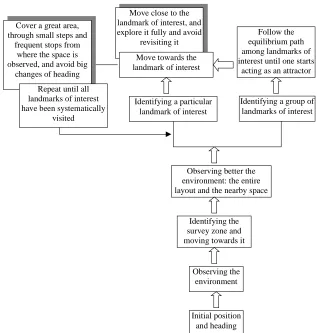
4.3 User Model of Navigation
Move close to the landmark of interest, and explore it fully and avoid
revisiting it
Initial position and heading Observing the
environment Identifying the survey zone and moving towards it
Observing better the environment: the entire layout and the nearby space Identifying a particular
landmark of interest
Identifying a group of landmarks of interest Move towards the
landmark of interest
Follow the equilibrium path among landmarks of interest until one starts
acting as an attractor Cover a great area,
through small steps and frequent stops from
where the space is observed, and avoid big
changes of heading
Repeat until all landmarks of interest have been systematically
[image:8.612.148.465.62.395.2]visited
Fig. 1.User Model of Navigation
5
Conclusion
The findings outlined in this paper can provide a new approach to the design of adaptive VEs for navigation support. At the heart of this approach lies a user model of navigation, expressed in terms of navigational rules and strategies.
The basic idea is to help low spatial users to navigate more effectively in VEs by enabling their access to efficient spatial rules and strategies. These rules and strategies are determined by analysing the high spatial users’ navigation patterns.
Such rules and strategies have a twofold purpose. On the one hand, they offer a deeper understanding of how high spatial users navigate in an unfamiliar indoor VE, thus offering an insight into their mental spatial model. On the other hand, such rules are merely simplifications which do not capture the full richness characterising user’s spatial behaviour. However, they identify some relevant features which have the considerable advantage of being fully articulated, and therefore able to be used in the system design. This is important, particularly when the design of VE aims to assist low spatial users in their spatial tasks.
References
1. G.L. Allen. The organization of route knowledge, new directions for child devel-opment. Children’s Conceptions of Spatial Relationships, 15:31–39, 1982.
2. D.R. Benyon and D.M. Murray. Applying user modelling to human–computer interaction design. Artificial Intelligence Review, 6:43–69, 1993.
3. R.M. Downs and D. Stea. Cognitive maps and spatial behavior: Process and products. In R.M. Downs and D. Stea, editors, Image and Environment, pages 8–26. Aldine Publishing Company, Chicago, IL, 1973.
4. T.W. Finin. GUMS—a general user modelling shell. In W. Wahlster and A. Kobsa, editors,User Models in Dialog Systems, pages 4–33. Springer-Verlag, Berlin, 1989. 5. G. Fischer. User modeling in human–computer interaction. User Modeling and
User-Adapted Interaction, 11(1-2):65–86, 2001.
6. D. Gentner. Psychology of mental models. In N.J. Smelser and P.B. Bates, editors,
International Encyclopedia of the Social and Behavioral Sciences, pages 9683–9687. Elsevier Science, Amsterdam, 2002.
7. G.R. Golledge. Human cognitive maps and wayfinding. In G.R. Golledge, edi-tor,Wayfinding Behaviour, pages 1–45. John Hopkins University Press, Baltimore, 1999.
8. R.A. Hart and G.T. Moore. The development of spatial cognition: A review. In R.M. Downs and D. Stea, editors,Image and Environment, pages 246–288. Aldine Publishing Company, Chicago, IL, 1973.
9. P.N. Johnson-Laird. Mental models of meaning. In A. Joshi, B. Webber, and I. Sag, editors, Elements of Discourse Understanding, pages 106–126. Cambridge University Press, Cambridge, 1981.
10. M. Laurendau and A. Pinard. The Development of the Concept of Space in the Child. International Universities Press, New York, NY, 1970.
13. D.R. Montello. A new framework for understanding the acquisition of spatial knowledge in large-scale environments. In M.J. Eganhofer and R. Golledge, editors,
Spatial and Temporal Reasoning in Geographic Information Systems, pages 143– 154. Oxford University Press, Oxford, 1998.
14. M.A. Norman. Some observations on mental models. In D. Gentner and A. Stevens, editors,Mental Models. Lawrence Erlbaum Associates, 1983.
15. G.M.P. O’Hare, K. Sewell, A. Murphy, and T. Delahunty. An agent based approach to managing collaborative work within both a virtual environment and virtual community. In Proceedings of the Workshop on Intelligent Agents for Computer Supported Co-Operative Work: Technologies & Risks, 2000.
16. J. Piaget and B. Inhelder. The Child’s Conception of Space. W.W. Norton and Co. Inc., New York, NY, 1967.
17. J.A. Preece. Guide to Usability, Human Factors in Computing. The Open Univer-sity, Suffolk, 1993.
18. C. Sas, G. O’Hare, and R. Reilly. Virtual environment trajectory analysis: A basis for navigational assistance and scene adaptivity. Future Generation Computer Systems. Special Issue on “Interaction and Visualisation Techniques for Problem Solving Environments”, 2004. In press.
19. C. Sas, G.M.P. O’Hare, and R.G. Reilly. On-line trajectory classification. InLecture Notes in Computer Science 2659, pages 1035–1044. Springer-Verlag, Berlin, 2003. 20. C. Sas, G.M.P. O’Hare, and R.G. Reilly. A performance analysis of movement patterns. In Lecture Notes in Computer Science 3038, pages 984–991. Springer-Verlag, Berlin, 2004.
21. A.W. Siegel and S.H. White. The development of spatial representations of large-scale environments. In H.W. Reese, editor, Advances in Child Development and Behavior, volume 10, pages 9–55. Academic Press, New York, NY, 1975.
22. P.W. Thorndyke and B. Hayes-Roth. Differences in spatial knowledge acquired from maps and navigation. Cognitive Psychology, 14:560–589, 1982.
23. E.C. Tolman. Cogintive map in man and animals. Psychological Review, 55:189– 208, 1948.
24. B. Tversky. Spatial mental models. In G.H. Bower, editor, The Psychology of Learning and Motivation: Advances in Research and Theory, volume 27, pages 109–145. Academic Press, New York, NY, 1991.
25. B. Tversky. Cognitive maps, cognitive collages, and spatial mental models. In A.U. Frank and I. Campari, editors, Spatial Information Theory: A Theoretical Basis for GIS, Proceedings COSIT’93, volume 716 ofLecture Notes in Computer Science, pages 14–24. Springer-Verlag, Berlin, 1993.