i
e-SAJADAH
KHAIRUDDIN BIN MOHAMMAD
This Report Is Submitted in Partial Fulfillment of Requirements for the Bachelor Degree of Electronic Engineering (Wireless Electronic)
Fakulti Kejuruteraan Elektronik dan Kejuruteraan Komputer Universiti Teknikal Malaysia Melaka
iii
STUDENT’S DECLARATION
“I hereby declare that this report is the result of my own work except for quotes as cited in the references”
Signature : ……….
Author : KHAIRUDDIN BINI MOHAMMAD
iv
SUPERVISOR’S DECLARATION
“I acknowledge that I have read this report and in my opinion this report is sufficient in terms scope and quality for the award of Bachelor of Electronic Engineering (Wireless
Electronic) With Honours”
Signature : ……….
Supervisor’s Name : DR. MOHD SAARI BIN MOHAMAD ISA
v
vi
ACKNOWLEDGEMENT
vii
ABSTRACT
viii
ABSTRAK
ix
TABLE OF CONTENT
STUDENT’S DECLARATION iii
SUPERVISOR DECLARATION iv
DEDICATION v
ACKNOWLEDGEMENT vi
ABSTRACT vii
TABLE OF CONTENT ix
LIST OF FIGURE xi
LIST OF TABLE xiii
LIST OF APPENDIX xiv
CHAPTER I: INTRODUCTION
1.1 Introduction 2
1.2 Objectives 4
1.3 Work Scope 4
1.4 Problem Statement 5
1.5 Methodology 6
CHAPTER II: LITERATURE REVIEW
2.1 Method of Literature Review 9
2.2 Introduction 10
2.3 Qibla Direction 11
2.3.1 Method to Locate Qibla Direction 13
2.4 Compass System 14
2.4.1 HMC 5883L 18
2.5 GPS System 19
2.6 Microcontroller 20
x CHAPTER III: METHODOLOGY
3.1 Introduction 26
3.2 Flowchart of the Project Development Planning 28
3.3 Project Progress 29
3.4 Project’s Methodology 30
3.5 Project’s Flow Chart 32
CHAPTER IV: RESULTS AND DISCUSSION
4.1 Introduction 34
4.2 e-Sajadah Circuit Design 35
4.3 e-Sajadah Coding Design 38
4.3.1 Libraries 38
4.3.2 Declaration 39
4.3.3 Compass Setting 41
4.3.4 Result’s Classification 41
4.3.5 Qiblah Formula 43
4.3.6 LEDs Code 44
4.4 e-Sajadah Fabrication 46
4.5 Qiblah Finding 48
4.6 Serial Monitor 51
4.7 Discussions 52
CHAPTER V: CONCLUSION AND FUTURE WORK
5.1 Conclusion 54
5.2 Future Work 55
xi
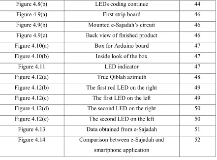
LIST OF FIGURES
Figure Title Page
Figure 1.1 Project Methodology 6
Figure 2.1 Method of Literature Review 9
Figure 2.2 Spherical Triangle for Determining Qibla 12
Figure 2.3 Ilustration From De Magnete 15
Figure 2.4 Declination Angles of Earth Magnetic Field
from True North in 2000 16
Figure 2.5 Difference of True North and Magnetic North 17
Figure 2.6 HMC5883L 18
Figure 2.7 Ublox Neo 6mv1 GPS module 20
Figure 2.8 Arduino Uno 22
Figure 2.9 Arduino software user interface 25
Figure 3.1 SDLC Phase 26
Figure 3.2 Steps of Methodology 27
Figure 3.3 Project’s Developement Flow Chart 28
Figure 3.4 Flow Chart Diagram 32
Figure 4.1 Schematic circuit diagram of e-Sajadah 35
Figure 4.2 e-Sajadah’s components assembly 36
Figure 4.3 Libraries used in the code 38
Figure 4.4(a) Declaration of variables 39
Figure 4.4(b) Declaration for LED pin out 40
Figure 4.5 Setting for digital compass moudule 41
Figure 4.6(a) Code for results classification 42
Figure 4.6(b) Results Classification shown in serial monitor 42
Figure 4.7 The code for calculation of Qiblah azimuth 43
xii
Figure 4.8(b) LEDs coding continue 44
Figure 4.9(a) First strip board 46
Figure 4.9(b) Mounted e-Sajadah’s circuit 46
Figure 4.9(c) Back view of finished product 46
Figure 4.10(a) Box for Arduino board 47
Figure 4.10(b) Inside look of the box 47
Figure 4.11 LED indicator 47
Figure 4.12(a) True Qiblah azimuth 48
Figure 4.12(b) The first red LED on the right 49
Figure 4.12(c) The first LED on the left 49
Figure 4.12(d) The second LED on the right 50
Figure 4.12(e) The second LED on the left 50
Figure 4.13 Data obtained from e-Sajadah 51
Figure 4.14 Comparison between e-Sajadah and
smartphone application
[image:12.612.109.550.70.395.2]xiii
LIST OF TABLES
Table Title Page
Table 4.1 List of component 36
Table 4.2 Values of digital compass module error on several mobile device
xiv
LIST OF APPENDIX
NO Title Page
1
CHAPTER I
INTRODUCTION
2 1.1 Introduction
Nowadays, people love to travel in any places around the world. During travelling, they need to bring their maps to find places and especially for Muslims, they need to bring their own Qiblah finder as they still have to perform prayer five times a day wherever they are. The Qiblah word origin from from Arabic language which means the direction that faced to Kaabah building located in Mecca, Saudi Arabia.[1] This direction is used by the Muslims to perform prayer as well as other religious obligations such as an animal slaughtering procedure where the head of an animal should be aligned to the Qiblah direction and the Muslims are buried with their body are turned right towards Qiblah.[2] It is a must for a Muslim to face the Qiblah when praying as stated in the Holy al-Quran in chapter two, Surah al-Baqarah verse 149, ―So from wherever you go out (for prayer, O Muhammad) turn your face toward al-Masjid al-Haram, and indeed, it is the truth from your Lord. And Allah is not unaware of what you do‖. Muslims need to sincerely make an attempt to find the correct direction of Qiblah.
3 way such as arithmetic method, trigonometry method, star sphere method and star disc method. These methods involve specific computation and require mathematical formulas.
In our modern era of technology, Qiblah determination methods has evolved into much more simpler way to use and do not need complicated computation or calculation due to invention of devices and applications such as Qiblah compass, mobile phone application that can automatically detect the direction of Qiblah wherever you are as well as non-mobile web-based applications. The most chosen one is mobile application because it is easy to use especially when travelling and when there is no access to mosque but the reliability of the applications were doubted. This is because there is a study on a mobile application to find Qiblah direction in a few prayer rooms found that in some prayer rooms, the Qiblah direction shown on the mobile application did not match to the Qiblah directions provided in the rooms.In Malaysia, JAKIM is considered as a reliable source and reference on the Islamic matter.[4] Furthermore, the development of mosque and prayer rooms in Malaysia has obtained an approval from Department of Survey and Mapping Malaysia (JUPEM) and others religious constitutional to ensure accurate Qiblah direction is determined.
4 1.2 Objectives
Objectives of the project:
To design and fabricate e-Sajadah that has the function to show correct direction of Qiblah at anywhere around the world.
1.3Work scope
This project consists of three parts, which is design, fabricate and measure. The scope of this project is to design e-Sajadah that has the function to show the correct direction of Qiblah which have below than 2.5 degree deviations. e-Sajadah is like a normal Sajadah with a small Qiblah indicator at the top side of the Sajadah which have two LEDs to show the user whether he/she has the right direction of Qiblah. The GPS module use in this project is to read the current longitude and latitude of the user‘s current position which is needed in order for microcontroller to calculate the direction of Qiblah. After the direction has been calculated, the value of the direction will be send to digital compass and the green LED will be lighted if the e-Sajadah has the right directions of Qiblah according to the calculated value. The compass module must have low value of angle deviation because more than three degree angle deviations could led to more than 300km misdirect from Kaabah. Therefore, choosing the right GPS module and digital compass is very essential because it will effect on accuracy of the Qiblah direction.
5 1.4 Problem statement
For centuries, Muslims all over the world face Mecca (towards Qibla or Ka‘bah) and perform prayer, five times a day. It is hard to determine the Qiblah direction and know the prayer of each prayer time. In the old days, people use stick and sees it shadow to know the prayer times and Qiblah direction.[5] Nowadays, researches and findings in astronomical help much in computing the prayer time and direction of Qiblah automated. There are certain applications in the website that are available to the user to know the Qiblah direction. They have to insert information on current location and the Qiblah and prayer information will be given.
As the technologies grow, various mobiles company gives Qiblah direction services. The problem is that the application itself is not portable and self-generated rely on the service itself. Services from websites need the user to have internet connections making it not practical for daily use. People commute every day, moving from one place to another place and they need to know the Qiblah direction in the current place they go. There is a device like ‗Qiblah Finder‘ that can help travellers by showing direction according to the latitude and longitude. The problem is this application does not really portable and cannot be used anywhere you like. To determine Qiblah direction, users are limited to have the Qiblah direction in certain places in Malaysia that the latitude and longitude has been pre-installed in the device. This method is quite troublesome to travellers since the person has to know the latitude and longitude of the current location.
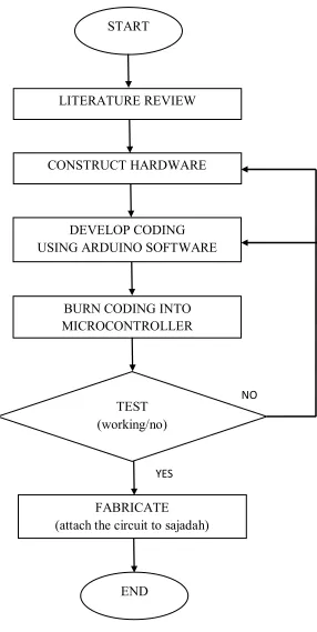
6 1.5 Methodology
Figure 1.1: Project Methodology START
CONSTRUCT HARDWARE LITERATURE REVIEW
DEVELOP CODING USING ARDUINO SOFTWARE
BURN CODING INTO MICROCONTROLLER
TEST (working/no)
NO
FABRICATE
(attach the circuit to sajadah)
7 This project begins with acquiring the information related to the digital Qiblah compass in literature review part. The information are obtained mainly from previous research paper which is journals, others are from reference books, e-Books and also the internet. The information obtained will be based on methods to determine Qiblah direction, instruments used, construction of the device, advantages, disadvantages, and also cost to make it. When the information is fully covered, then the process of constructing the circuit begins. The circuit consists of microcontroller, digital compass, GPS module, and LED and assembled on bread board first for testing purposes. After the circuit is functions according to the plan, than it will be solder to the strip board.
The coding for microcontroller is done using Arduino software. All the required information and knowledge about the software on how to write the instructions set, to compile the coding and to burn it into the microcontroller are learned at Arduino website. The construction of the coding consists of the instructions set for the GPS module to read the user‘s current longitude and latitude and send it to microcontroller to calculate for the Qiblah direction from the user‘s location, digital compass to indicate the direction of Qiblah which connected to two LEDs as it indicator. After the coding has been developed, it is burned into microcontroller using Arduino board.
Next, after the coding is successfully burned into the microcontroller, the Qiblah indicator circuit is tested for the user current position of Qiblah direction. The Qiblah direction is referred from mosque to see whether it will have the same direction or not. If he result is not from what is expected, then the hardware and coding needs to be checked whether there is problem on that part. The circuit must be checked for its connection and power supply and the coding must be checked for its functionality and the instructions set for GPS module, digital compass, and also formula to calculate the Qiblah direction.
8
CHAPTER II
LITERATURE REVIEW
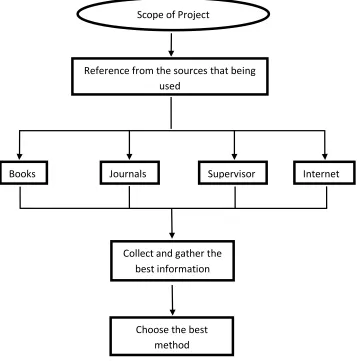
9 2.1 Method of literature review
Figure 2.1: Method of Literature Review
Scope of ProjectReference from the sources that being used
Supervisor Internet Journals
Books
Collect and gather the best information
[image:23.612.177.534.143.504.2]10 2.2 Introduction
The Qiblah is the direction to the Ka‘bah, but what precisely is that direction? Sheikh Muhammad S Al-Munajjid (2011, 19 july, ‗They discovered that their mosque deviates from the Qiblah by 17 degrees‘).[6] A source ‗Islam question and answer‘ website stated that the one who is close to the Ka‘bah is required to face it head on, but the one who is far away from it must face its direction according to the majority of Islamic scholars. However, if one does not have any information about the direction of the Qiblah, the direction is between west and east. If there is any guidance or a village nearby, one must ask and find out about the Qiblah direction.[7] It is our obligation to face the Ka‘bah because it is one of the conditions of the prayer.
Ibn Qudamah Rahimullah (may Allah have mercy on him) said in al-Mughni (the most widely known textbook of Hanbali fiqh), facing the Qiblah is a condition of prayer being valid, and there is no difference between both in compulsory prayer or Sunnah prayers.[8] Hence, finding the Qiblah accuracy is crucial for Muslims to face the correct direction and to fulfill our worship to Allah.