Development and assessment of a medium-range real-time kinematic GPS
algorithm using an ionospheric information filter
Ming Yang1, Chin-Hsien Tang1, and Ting-To Yu2
1Department of Surveying Engineering, National Cheng Kung University, Tainan, Taiwan 2Satellite Geoinformatics Research Center, National Cheng Kung University, Tainan, Taiwan
(Received January 31, 2000; Revised August 28, 2000; Accepted August 28, 2000)
The key requirement of centimeter-level real-time kinematic (RTK) positioning using the Global Positioning System (GPS) relies on the ability to fast and accurately determine the ambiguities of carrier-phase observations to their inherent integer values. In addition, the identification must be completed on the fly since the remote receiver is constantly in motion. The Kalman filter-based algorithm described in this paper uses an ionospheric information filter to perform on-the-fly phase ambiguity resolution for high precision RTK applications. Experiments based on 16 independent test baselines ranging from 10–50 km in length indicate that the algorithm can reliably achieve centimeter-level positioning accuracy, provided that a small enough threshold value for ambiguity identification is pre-defined and that sufficient geometry change in the GPS constellation is observed. Experimental results also show that the convergence (initialization) time for ambiguity resolution is linearly proportional to instantaneous baseline length, and the slope of the regression line increases with tighter ambiguity identification criteria.
1.
Introduction
Precise determination of double-differenced GPS phase ambiguities on the fly is the most important task for high precision kinematic applications (Yanget al., 1994; Goad and Yang, 1997; Han, 1997; Teunissen, 1997; Mohamed and Schwarz, 1999; Wang, 2000). Today, most GPS-based high precision RTK surveys have a limitation on the distance be-tween the rover and the base receivers, the so-called baseline length. Rarely will one find routine centimeter-level RTK applications over longer baselines. The main obstacles in longer-range real-time ambiguity resolution are twofold— residual orbital error in the GPS broadcast ephemeris, and residual signal delay caused by the atmosphere including the ionosphere and the troposphere. In general, the resolu-tion of GPS phase ambiguity is simpler and straightforward for short-range applications, as the differential influences on GPS observables caused by the GPS broadcast orbits and the atmosphere can be canceled by the sufficient similarities at the two ends. However, for longer-range baselines, the above assumption is no longer valid, and consequently the systematic influences must be carefully modeled.
In this paper, the term “medium-range” thus refers to the assumption that the double-differenced GPS phase obser-vations are sufficiently insensitive to the relatively smaller residual effects, namely, the GPS orbital error and the tropo-spheric refraction. Hence, only the differential ionotropo-spheric influence needs to be effectively modeled for successful res-olution of phase integer ambiguity. This is particularly im-portant to engineers and geodesists who wish to perform
Copy right cThe Society of Geomagnetism and Earth, Planetary and Space Sciences (SGEPSS); The Seismological Society of Japan; The Volcanological Society of Japan; The Geodetic Society of Japan; The Japanese Society for Planetary Sciences.
high precision RTK surveys in areas located in the so-called equatorial anomaly region. Taiwan for example, at 10–14◦N geomagnetic, is situated in the region (Huanget al., 1989). Irregularities of the ionosphere mainly occur in the equato-rial anomaly region that is in the shape of a belt surrounding the earth’s geomagnetic equator, as well as in the polar auro-ral zones; however, a very high electron content only occurs in the equatorial region (Seeber, 1993, p. 306). As a result, noticeable residual ionospheric signals can be seen in double-differenced phase observations even over short baselines in this area (ibid.).
It has long been recognized that using multiple reference stations improves differential GPS positioning results. Such a multiple-reference configuration is generally referred to as wide-area differential GPS (WADGPS), mainly imple-mented for single frequency code or phase-smoothed code positioning with varying levels of accuracy from a few decimeters to a few meters (Ashkenaziet al., 1993; Bertiger
et al., 1998). In recent years, researchers started to take advantage of the multi-reference configuration and success-fully achieved fast ambiguity resolution for centimeter-level RTK positioning using dual frequency carrier-phase mea-surements. For instance, Han (1997), Raquet and Lachapelle (2000) independently developed methods to process dual fre-quency GPS data and perform interpolation of differential ionospheric delays using a network of reference stations.
Nevertheless, due to the cost factor, the majority of to-day’s high precision RTK positioning projects and commer-cial products still operate on the so-called single-reference mode, i.e., only one reference station is used in the com-munication link and as a result, no interpolation of differ-ential influences can be performed. This means that in the single-reference mode, the only direct source that contains
information about the differential ionospheric signals is the GPS dual frequency phase and pseudorange observations. To model the differential ionospheric refraction for a single baseline, Goad and Yang (1997) proposed an approach based on a smoothing technique that operates on single-differenced GPS measurements. In this approach, all available GPS data are combined by a smoother for the estimation of a group of time-varying ionospheric parameters. For real-time ap-plications, however, such a smoother-based technique is no longer effective. Moreover, since computational time must be taken into consideration in a real-time situation, it is ad-vantageous to reduce the number of estimated parameters in the state vector to its minimum. Consequently, the process-ing of sprocess-ingle-differenced measurements is not optimal for RTK implementation.
In this paper, a Kalmanfilter-based algorithm with a real-time application capability is used to combine double-differenced phase and pseudorange data, and to take advan-tage of the stochastic structure in the ionospheric signal. An integer transformation procedure is also incorporated into the algorithm to decorrelate thefloat ambiguity estimates for optimal identification of their correct integer values.
As both the accuracy level and time factor play crucial roles in high precision RTK applications, the purpose of this paper is to assess, with independent test baselines of various lengths, the algorithm’s ability to achieve centimeter-level kinematic positioning, and to investigate the relationship between convergence time, instantaneous baseline distance, and threshold values for ambiguity identification.
2.
The Filter
The GPS dual frequency double-differenced observations measured between receiversiandj(subscript), and satellites
kandl (superscript) are given as follows (Goad and Yang, 1997; Yang and Lo, 2000):
kl
measured at the L1 and L2 frequencies, respectively. The
term ρ is the geometric distance between the two satellite antennas and the two receiver antennas whileI/f2stands for
thefirst-order atmospheric ionosphere refraction with group delays associated with the pseudoranges and phase advances associated with the phases. The wavelengths of the L1 and
L2 phases areλ1 ≈ 19 cm andλ2 ≈ 24 cm, respectively.
The measurement noise is characterized by the error terms ande. The integer ambiguities associated with the L1and
L2phases are denoted asN1andN2, respectively.
The tropospheric effectT can be estimated together with surface meteorological data by some tropospheric correction
models, for instance, those of Hopfield (1969) and Saastamoinen (1972). Despite the differences between the various models, when the elevation angle is above 20 de-grees, different models give very similar estimates of the tropospheric refraction (Solheim, 1993).
The effect of ionosphere on GPS measurements is gener-ally regarded as a time-dependent signal that continuously changes in time as the electron density varies with time and location in the ionosphere (Klobuchar, 1991). In addition to the dependence on time, the effect of differential iono-sphere is also a function of baseline length (Dong and Bock, 1989). When the two receivers are close to each other, the differential ionospheric refraction is greatly reduced due to cancellation; however, as the baseline length is increased, the reduction becomes less significant (Yanget al., 1994).
The model for estimating the phase ambiguities is given in a Kalmanfilter form. At a given epochtn, the linearized observation equation is formulated as follows:
Zn =Hn·xn+n (2)
whereZnis the observation vector comprising the four mea-surements, and a zero a priori observation of the double-differenced ionosphere. The error vector isand H is the design matrix. Here the state vector is defined as
xn= reference position of the moving receiver jat epochtn. The term I/f2
1 stands for the L1double-differenced ionospheric
refraction associated with the measurements. The double-differenced integer ambiguities of the L1and widelane (L1−
L2) phases are denoted as N1 and N1 −N2, respectively.
The choice of the widelane phase is mainly for its longer wavelength.
The prediction (−) of the state vector at the next epoch
n+1 is derived from the update (+) of epochnas follows (Gelb, 1979, p. 110):
xn+1(−)=φnxn(+)+wn, wn ∼N(0,Qn). (4)
In this study we define the state transition matrixφn and corresponding covariance matrixQnas
wherepi onrepresents the prediction operator used to predict the double-differenced ionospheric delay from one epoch to the next, over a time intervalτ and a baseline length change δwhile the corresponding variance of the prediction error is denoted asσ2
W i on. Their values are given by Goad and Yang (1997) as
pi on =e−(|τ|/T+|δ|/D), σ2
W i on =σ∞2(1−e−2(|τ|/T+|δ|/D))
(6)
whereT =64 min stands for thefirst-order correlation time for the double-differenced ionosphere, and D = 1500 km represents thefirst-order correlation distance. The variance of the double-differenced ionosphere withτandδas the two independent variables isσ∞2 =2.0 m2.
The remaining diagonal elements of the state transition matrixφnare set to one, indicating that in thefilter the pre-dicted values for the moving receiver’s position and phase ambiguities are unchanged over time. Obviously this as-sumption cannot be true. Therefore, a very large number is assigned to each of thefirst three diagonal elements of the corresponding covariance matrixQn, in order to effectively neglect any previous information about the moving receiver’s position. The last two diagonal elements ofQnare set to zero when continuous tracking is maintained; otherwise, they are set to very large numbers when estimation of new ambiguities is requested.
3.
Fixing Integer Ambiguities
The most intuitive way to constrainfloat ambiguity es-timates to integer values is to round the eses-timates to their respective nearest integers. However, this method is optimal only if the estimates have reached a steady state with high precision, and the correlation between the estimates is low. In the algorithm, the integer transformation concept proposed by Teunissen (1995, 1997) that minimizes both the correla-tion between the integer ambiguities and the elongacorrela-tion of the error ellipsoid is used to decorrelate the normally highly correlated GPS phase ambiguities. Suppose that two double-differenced phase ambiguity estimates and their associated covariance matrix are available from thefilter as
ˆ
The integer transformation process is performed as (Teunissen, 1995)
where the symbol{ }stands for rounding to the nearest in-teger. The associated covariance matrix is consequently ob-tained as
The integer transformation procedure generates a linear combination of the original integer ambiguities to achieve the goal of decorrelation (Teunissen, 1995). To successfully resolve the correct integer values of the transformed (and decorrelated) ambiguities, two conditions need to be fulfilled at once: thefloat estimates should reach a steady state with high precision, and the correlations between the estimates should be sufficiently low. In general, if the integer transfor-mation procedure is successful, the above conditions can be both fulfilled (Peiliang Xu, 2000, personal communication). In this study, a simplified measure is adopted to determine the ambiguity integers. If the associated standard deviations of the transformed ambiguity estimates are smaller than a pre-defined threshold valueκ
√
σaˆ ≤κ, (10)
then the transformedfloat ambiguity estimates are rounded (and constrained) to their nearest integers, and the state vec-tor and the covariance matrix of thefilter are updated accord-ingly.
To extend from the two-dimensional case to a more gen-eral multi-dimensional case, the integer transformation pro-cedure is repeated and applied to all possible ambiguity pairs in the state vector. After the resolution of phase integer am-biguity, precise kinematic positioning can be continuously performed.
4.
Test Results
4.1 Test data description
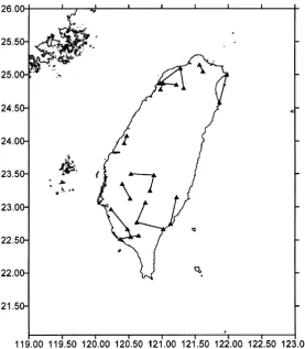
To investigate the applicability of the proposed algorithm for resolution of the phase ambiguity on the fly, 16 inde-pendent GPS baselines ranging from 10–50 km in length were studied. About 40 min of dual frequency test data were collected between January and April 1997, with a sampling interval of 15 seconds and a satellite elevation cutoff angle of 10 degrees. The test data were in fact static baselines and their“true”static baseline solutions were obtained from off-line data processing using the GPSurvey 2.0 software (Trimble Navigation, Sunnyvale, CA, U.S.A.), with precise GPS ephemeris from the International GPS Service (Neilan
et al., 1997; Beutleret al., 1999). Figure 1 displays the spa-tial distribution of those baselines, which covered various regions of the island of Taiwan, including the central moun-tainous areas with elevations greater than 2 km as well as low-elevation areas near the east and west coastlines.
4.2 Result analyses
The objective of the experiment was to examine the perfor-mance of the proposed algorithm. Three different threshold values,κ =0.15, 0.20, and 0.30 cycles, for the determina-tion of phase ambiguity integer were tested in the experiment. To simulate the real-time scenario, GPS broadcast ephemeris was used.
Fig. 1. Distribution of test baselines.
Fig. 2. RMS values vs. baseline distance for various threshold values.
RMS values are within ±3 cm, and all the vertical RMS values are within±4.2 cm. The length of the baseline only has a small effect on the accuracy level within the distance range of the test baselines. As the baseline distance becomes longer, the RMS values in general only slightly increase. For the loosest threshold value, 0.30 cycles, however, wrong integer values of phase ambiguities arefixed for one of the baselines (a 43-km line), as the corresponding RMS values are as large as±17.1 cm vertically, and±7.5 cm horizontally. After excluding the incorrect line, similar accuracy estimates to the cases of the two tighter threshold values are obtained. Figure 3 displays the time (number of epochs) needed for the algorithm tofix integer ambiguity for the three criteria. It is apparent that in all three cases, more time is needed for longer baselines, and the relationship resembles straight lines. Moreover, as expected, the slope of the regression lines increases with tighter threshold values.
differ-Fig. 3. Number of epochs to resolve integer ambiguity vs. baseline distance.
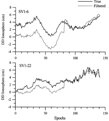
Fig. 4. True andfiltered double-differenced ionospheric effects for a 47-km line.
ences in the beginning of the filtering process, thefiltered ionospheric estimate gradually approaches the true value as thefilter steadily converges. After the resolution of integer ambiguity, the two quantities stay close to each other within 1 cm, i.e., about one twentieth of the wavelengths of the L1
and L2phases.
5.
Discussion and Conclusion
At present, most high precision RTK geodetic surveys still operate on the single-reference mode where only one base
station is used in the communication link. Since no interpo-lation of differential ionospheric influences can be performed in the single-reference mode, instantaneous ambiguity res-olution in real time becomes very difficult over baselines where the differential ionospheric effect cannot be assumed to be zero. As a result, it is important not only to devise new algorithms for single-baseline RTK ambiguity resolution, but also to investigate the performance of the algorithms from a variety of perspectives—the achievable positioning accuracy, the choice of ambiguity resolution criterion, the convergence (initialization) time, and the relationship between the base-line length and the above factors.
In this paper, an algorithm for medium-range RTK GPS positioning is used to resolve phase ambiguities over test baselines ranging from 10–50 km in length. The algorithm is combined with an ionospheric informationfilter and an in-teger transformation procedure for optimal phase ambiguity resolution.
The use of the algorithm for performing ambiguity res-olution yielded varying results, depending on the adopted threshold values for ambiguity identification and the instan-taneous baseline distances. From analyses of test results obtained from 16 independent GPS baselines, correct inte-ger ambiguity resolution along with high precision real-time kinematic positions can be reliably obtained, so long as a small enough threshold value for ambiguity identification is pre-defined and sufficient geometry change in the GPS constellation is accumulated over time. Naturally, longer convergence time is needed for smaller threshold values. As the baseline distance increases, so does the required con-vergence time, and the relationship resembles a straight line whose slope increases with tighter threshold values.
Acknowledgments. This research is supported in part by the Na-tional Science Council, R.O.C., under grant NSC 89-2211-E-006-127. The authors specially thank Dr. Peiliang Xu and Dr. Gang Lu for their important suggestions and constructive criticism that greatly improved the quality of the paper.
References
Ashkenazi, V., C. J. Hill, W. Y. Ochieng, and J. Nagle, Wide-area differential GPS: a performance study,Navigation,40, 297–319, 1993.
Bertiger, W. I., Y. E. Bar-Sever, B. J. Haines, B. A. Iijima, S. M. Lichten, U. J. Lindqwister, A. J. Mannucci, R. J. Muellerschoen, T. N. Munson, A. W. Moore, L. J. Romans, B. D. Wilson, S. C. Wu, T. P. Yunck, G. Piesinger, and M. Whitehead, A real-time wide area differential GPS system,Navigation,44, 433–447, 1998.
Beutler, G., M. Rothacher, S. Schaer, T. Springer, J. Kouba, and R. E. Neilan, The international GPS service (IGS): an interdisciplinary service in support of earth sciences,Adv. Space Res.,23, 631–653, 1999. Dong, D. and Y. Bock, Global positioning system network analysis with
phase ambiguity resolution applied to crustal deformation studies in Cal-ifornia,J. Geophys. Res.,94, 3949–3966, 1989.
Gelb, A.,Applied Optimal Estimation, 370 pp., MIT Press, Cambridge, MA, U.S.A., 1979.
Goad, C. C. and M. Yang, A new approach to precision airborne GPS posi-tioning for photogrammetry,Photogrammetric Engineering and Remote Sensing,63, 1067–1077, 1997.
Han, S., Carrier Phase-based Long-range GPS Kinematic Positioning, Ph.D. Thesis, 185 pp., School of Geomatic Engineering, The University of New South Wales, Sydney, Australia, 1997.
Hopfield, H. S., Two-quartic tropospheric refractivity profile for correcting satellite data,J. Geophy. Res.,74, 4487–4499, 1969.
Klobuchar, J. A., Ionospheric effect on GPS,GPS World,2, 48–51, 1991. Mohamed, A. H. and K. P. Schwarz, A simple and economical algorithm for
GPS ambiguity resolution on thefly using a whiteningfilter,Navigation,
45, 221–231, 1999.
Neilan, R. E., J. F. Zumberge, G. Beulter, J. Kouba, The international GPS service: a global resource for GPS applications and research, Proc. ION GPS-97, 883–889, 1997.
Raquet, J. and G. Lachapelle, Development and testing of a kinematic carrier-phase ambiguity resolution method using a reference receiver net-work,Navigation,46, 283–295, 2000.
Saastamoinen, I. I., Contribution to the theory of atmospheric refraction, Bulletin Geodesique,107, 13–34, 1973.
Seeber, G.,Satellite Geodesy, 531 pp., Walter de Gruyter, Berlin, Germany, 1993.
Solheim, F. S., Use of pointed water vapor radiometer observations to im-prove vertical GPS surveying accuracy, Ph.D. Dissertation, Department of Physics, University of Colorado, Boulder, CO, U.S.A., 1993.
Teunissen, P. J. G., The invertible GPS ambiguity transformations, Manuscripta Geodaetica,20, 489–497, 1995.
Teunissen, P. J. G., The geometry-free GPS ambiguity search space with a weighted ionosphere,J. Geod.,71, 370–383, 1997.
Yang, M. and C. F. Lo, Real-time kinematic GPS positioning for centimeter level ocean surface monitoring,Proc. Natl. Sci. Counc. ROC(A),24, 79–
85, 2000.
Yang, M., C. C. Goad, and B. Schaffrin, Real-time on-the-fly ambiguity resolution over short baselines in the presence of anti-spoofing, Proc. 7th International Technical Meeting of the Satellite Division of the ION, 519–525, 1994.
Wang, J., Stochastic modeling for real-time kinematic GPS/GLONASS po-sitioning,Navigation,46, 297–305, 2000.