World Maritime University
The Maritime Commons: Digital Repository of the World
Maritime University
World Maritime University Dissertations Dissertations
2000
VTS [vessel traffic services] in the Singapore strait :
an investigation into mandatory traffic control
Mohammed Segar Abdullah World Maritime University
Follow this and additional works at:http://commons.wmu.se/all_dissertations
This Dissertation is brought to you courtesy of Maritime Commons. Open Access items may be downloaded for non-commercial, fair use academic
Recommended Citation
Segar Abdullah, Mohammed, "VTS [vessel traffic services] in the Singapore strait : an investigation into mandatory traffic control" (2000).World Maritime University Dissertations. 419.
World Maritime University
Malmö, Sweden
VTS IN THE SINGAPORE STRAIT:
AN INVESTIGATION INTO MANDATORY
TRAFFIC CONTROL
By
MUHAMMAD SEGAR ABDULLAH
Republic of SingaporeA dissertation submitted to the World Maritime University in partial fulfilment of the requirements for the award of the degree of
MASTER OF SCIENCE
in
MARITIME ADMINISTRATION AND ENVIRONMENTAL PROTECTION
2000
DECLARATION
I certify that all the material in this dissertation that is not my own work has been identified, and that no material is included for which a degree has previously been conferred on me.
The contents of this dissertation reflect my own personal views, and are not necessarily endorsed by the University.
………. Muhammad Segar Abdullah Date: 21 August 2000
Supervised by:
Capt. Sven-Åke Wernhult
Lecturer, Maritime Administration and Environmental Protection World Maritime University
Internal Assessor:
Dr. Proshanto K. Mukherjee
Course Professor, Maritime Administration and Environmental Protection World Maritime University
External Assessor:
Capt. Kjell Grahn Visiting Lecturer
DEDICATION
To my inspiration in life, my wife Fatimah and my children for their
constant support and forbearance in the quest for this degree.
ACKNOWLEDGEMENTS
I am grateful to the Director-General of the Maritime and Port Authority of Singapore, Mr Chen Tze Penn for giving me the opportunity to pursue this post graduate degree.
A special word of gratitude to Capt. Khong Shen Ping, Ms Lee Chin Neo, Capt. Mark Heah Eng Siang and Mr Michael Tang for their support and encouragement.
In the writing of this dissertation, I owe a debt to more people than there is space to name and thank - those who have assisted me in many ways and those whose books, journals and articles that I have read. But a special of word of thanks to:
• Course Professor P K Mukherjee for his encouragement to excel and sharing his vast experience and knowledge in maritime law;
• Professor J R F Hodgson, Capt. S-Å Wernhult and Mr Max Mejia for
their guidance and patience in the supervision of this dissertation;
• Capt. Francis Wee, Capt. Wilson Chua, Capt. Sangam and Mr Parry Oei for their advice, inputs and comments;
• Mr William Seow, Mr Roger Teo and PSA Marine pilots for providing valuable feedback;
• Commander Rod Johnson and Mr Eric Musson of UK, Maritime
Coastguard Agency for their information on Dover Strait and CNIS;
• MPA officers, Peggy Koh, Sandra Wee and Kamalanathan for producing the relevant chartlets;
• WMU library staff, Susan Wangeci Eklow and Cecilia Denne for their invaluable assistance in searching for reference materials; and
• Authors and commentators of the various textbooks, journals and articles which I have read. Their names and works are duly acknowledged in the bibliography.
ABSTRACT
Title of Dissertation: VTS in Singapore Strait - An Investigation into Mandatory Traffic Control
Degree: Master of Science in Maritime Administration and Environmental Protection
This dissertation investigates mandatory traffic control in the Singapore Strait using the Singapore Vessel Traffic Information System (VTIS) as a model. The three littoral States i.e. Singapore, Indonesia and Malaysia have introduced many safety measures to enhance safety of navigation in the Singapore Strait. In addition, the Maritime and Port Authority of Singapore has established VTIS to provide information and navigational assistance to shipmasters, as well as warnings when there is a potential risk of close quarter situations.
The development of vessel traffic service (VTS), the types of VTS and their significant contributions to safety of navigation are discussed. Also, the effectiveness of the safety measures that have been implemented in Singapore Strait is examined. To further enhance the safety of navigation in the Singapore Strait through VTS, a definition for the shore-based control - mandatory traffic control is proposed. There are similarities in the air traffic service (ATS) and vessel traffic service. The principles and concepts of ATS are examined to identify the areas in which VTS differs and suitable solutions are provided to address these concerns for a shore-based control by VTS.
the common problems faced by VTS authorities and the need for further control measures. Shipowners, shipmasters, pilots and shipping organisations have valid concerns. Some of the issues related to mandatory traffic control are controversial and can be resolved at appropriate IMO forums.
Introducing mandatory traffic control is a complex and long drawn process and the importance of Singapore Strait can be overstated. Hence, in the final chapter a number of recommendations are made to enhance safety of navigation with ultimate aim to achieve shore-based control by VTS.
KEYWORDS:
Air traffic service AIS transponderChannel Navigation Information Service DGPS/DGLONASS
ECDIS ENC
Mandatory traffic control
Maritime and Port Authority of Singapore Shore-based control
TABLE OF CONTENTS
Declaration ii
Dedication iii
Acknowledgements iv
Abstract v
Table of Contents vii
List of Tables xii
List of Figures xiii
List of Abbreviations xiv
Chapter 1 Introduction 1
Chapter 2 Vessel Traffic Service
2.1 Background of VTS Development 5
2.2 Types of VTS 7
2.2.1 Types of Service provided by VTS 8
2.3 Legal Status of VTS 9
2.4 Safety measures Implemented in Singapore Strait 11
2.4.1 Routeing System 12
2.4.2 Rules for Vessels Navigating Through the Straits of Malacca and Singapore
12
2.4.3 Extension of Traffic Separation Schemes 13 2.4.4 Mandatory Reporting System "STRAITREP" 14
2.4.5 Surveys of Shoals and Wrecks 15
2.4.6 ECDIS and DGPS 16
2.5 Could Safety of Navigation in Singapore Strait Further Enhanced through VTS?
17
Chapter 3 Comparisons Between Air Traffic Services and Vessel Traffic Services
3.1 Background 19
3.2 Rules of the Air 20
3.3 Air Traffic Services 21
3.4 Guidelines and Criteria for VTS 22
3.5 Guidelines on Qualification and Training of VTS Operators
23
3.6 Legal Considerations - Relationship between ATC and Pilot Vs Relationship between VTS and Shipmaster
25
3.6.1 Relationship between ATC and Pilot 25 3.6.2 Relationship between VTS and Shipmaster 27
3.7 Legal Liability 28
Chapter 4 Development of Technology to Enhance Safety of Navigation
4.1 Modern Technology 30
4.2 Electronic Chart Display and Information System 30 4.3 Electronic Navigational Chart (ENC) Data Format 33
4.4 DGPS/DGLONASS 34
4.5 Automatic Identification Systems (AIS) 37 4.5.1 Digital Selective Calling System 38 4.5.2 Universal Automatic Identification System 38 4.5.3 Singapore's Experience in AIS
Transponder Technology
40
4.5.4 European Countries Experience in AIS Transponder Technology
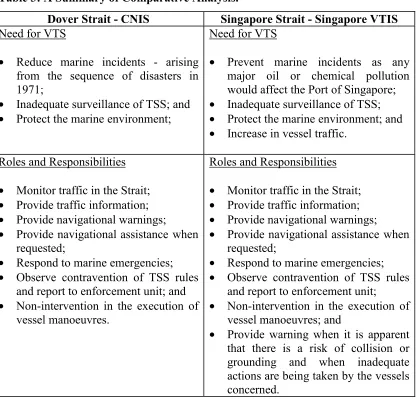
Chapter 5 A Comparative Analysis between Dover Strait and Singapore VTS
5.1 Background 44
5.2 Need for VTS Systems in the Dover Strait And Singapore Strait
45
5.3 Roles and Responsibilities of CNIS and Singapore VTIS
48
5.4 Difficulties Encountered by CNIS and Singapore VTIS
50
5.5 Analysis 51
Chapter 6 Shore-based Control of Vessel Movements in Singapore Strait
6.1 Traffic Organisation Service 55
6.1.1 Pros and Con of Traffic Organisation Service 55
6.2 Mandatory Traffic Control 56
6.2.1 Pros and Con of Mandatory Traffic Control 57 6.3 Evaluation of Shore-based Controls 58
6.3.1 Liability Aspect 58
6.3.2 Responsibility of Navigation ultimately lies on the Bridge of Ships
59
6.3.3 Radar Target Identification 60
6.3.4 Freedom of Transit Passage 61
Chapter 7 Implementation of Mandatory Traffic Control in Singapore Strait
7.1 Implementations prior to the introduction of Mandatory Traffic Control in the Singapore Strait
62
7.4 Qualification and Training Standards for VTS Personnel
64
7.5 Revision of the Ship Routeing System in Singapore Strait
66
7.6 Designate the Area to be under Mandatory Traffic Control
67
7.7 Changes to International Conventions 68
7.7.1 SOLAS Chapter V 68
7.7.2 International Regulations for Preventing Collisions at Sea
68
7.8 Legislation and Liability 69
Chapter 8 Alternatives to Mandatory Traffic Control in Singapore Strait
8.1 Alternate Measures 71
8.2 Pilotage Services 71
8.3 VTS Sailing Plans 74
8.4 Pro-active Management by VTS (Traffic Organisation Service)
74
Chapter 9 Conclusions and Recommendations
9.1 Conclusions 77
9.2 Recommendations 80
9.2.1 Phase 1 - For Traffic Organisation Service (Pro-active Management)
80
9.2.2 Phase 2 - For Mandatory Traffic Control 81
Appendices
Appendix 1 Traffic Separation Scheme in Malacca and Singapore Straits, 1981
87
Appendix 2 Extended Traffic Separation Scheme in Malacca and Singapore Straits, 1998
88
Appendix 3 Mandatory Reporting System "STRAITREP" Operational Sector 1- 7
89
Appendix 4 Mandatory Reporting System "STRAITREP" Operational Sector 7- 9
90
Appendix 5 CNIS - Radar Coverage Area 91
Appendix 6 Singapore VTIS - Radar Coverage Area 92
Appendix 7 Detailed Dimension of Traffic Separation Scheme in Singapore Strait
93
Appendix 8 Proposed Revision of Traffic Separation Scheme and Areas to be Dredged in Singapore Strait
LIST OF TABLES
Table 1 Statistics on Collisions 20
Table 2 Enhancement to Safety and Surveillance Systems in Dover Strait
46
Table 3 A Summary of Comparative Analysis 51
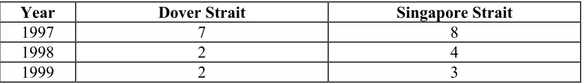
Table 4 Statistics of Vessel Movements in the Straits of Dover and Singapore
52
Table 5 Statistics of Contravention of TSS Rule in the Straits of Dover and Singapore
52
Table 6 Statistics of Collisions in the Straits of Dover and Singapore
53
LIST OF FIGURES
LIST OF ABBREVIATIONS
AIS Automatic identification system ARPA Automatic Radar Plotting Aid ATC Air traffic controller
ATS Air traffic service
BAFEGIS Baltic Sea Ferry Guidance and Information System BIMCO Baltic and International Maritime Council
CNIS Channel Navigation Information Service
COLREG Convention on the International Regulations for Preventing Collisions at Sea, 1972 as amended
CPS Vessel-Conflict Prediction System
DGLONASS Differential Global Navigation Satellite System DGPS Differential Global Positioning System
DOD Department of Defence, United States DSC Digital Selective Calling
ECDIS Electronic Chart Display and Information System ECS Electronic chart system
EEZ Exclusive economic zone ENC Electronic navigational chart GLONASS Global Navigation Satellite System
GMDSS Global Maritime Distress and Safety System GPS Global Positioning System
IAIN International Associations of Institutes of Navigation IALA International Association of Lighthouse Authorities IAPH International Association of Ports and Harbours ICAO International Civil Aviation Organization
IFSMA International Federation of Shipmasters' Association IHO International Hydrographic Organisation
IMO International Maritime Organisation IMPA International Maritime Pilots' Association IPS Institute of Policy Studies, Singapore ISM International Safety Management LNG Liquefied natural gas
MARPOL 73/78 International Convention for the Prevention of Pollution from Ships, 1973, as modified by the Protocol of 1978, as amended MCA Maritime and Coastguard Agency of United Kingdom
MPA Maritime and Port Authority of Singapore MSC Maritime Safety Committee, IMO
RCDS Raster chart display system SA Selective availability
SATSA Swedish Air Traffic Services Academy
SIGTTO Society of International Gas Tanker & Terminal Operators Ltd SIPS Ship Identification and Positioning System
SOLAS International Convention for Safety of Life at Sea, 1974, as amended
STCW International Convention on Standards of Training, Certification and Watchkeeping for Seafarers, as revised in 1995
TSS Traffic separation scheme
UNCLOS United Nations Convention on the Law Of the Sea, 1982 VLCC Very large crude carrier
VTIS Vessel Traffic and Information System VTS Vessel traffic service
Chapter 1
Introduction
The Secretary-General of the International Maritime Organization, O'Neil (1999) said that:
the oldest tradition of the sea - that the authority of the ship's master should be paramount - may no longer be valid in a world that is becoming dominated by new technology. I think that we should ask ourselves if the time has not come to question this approach and to empower the shore authorities, in certain cases, to order ship to take whatever action is necessary to avoid an accident.
The principle purpose of this dissertation is to examine whether there are merits in the S.G.'s call to empower shore-based authorities, such as vessel traffic service (VTS) authority, to introduce mandatory traffic control. In civil aviation, positive control of aircraft by ground-based air traffic controller is accepted. The concepts and principles adopted by civil aviation could be introduced to vessels within the coverage of VTS.
In 1990, Maritime and Port Authority of Singapore (MPA) established the Singapore Vessel Traffic Information System (VTIS) to enhance safety of navigation by providing navigational and traffic information to shipmasters, as well as warnings when there is a potential risk of close quarters situations or groundings. MPA has been continuously upgrading the VTIS with the latest state-of-the-art marine surveillance, communication and information system. Experience has shown that, in spite of the timely information and warnings provided by the VTIS, shipmasters took inadequate actions which resulted in collisions and groundings.
In 1997, the risk of major environmental and ecological disaster became a reality when the loaded tanker EVOIKOS spilled 28,500 tonnes of oil in the Singapore Strait after a collision. In 1998, the car carrier HUAL TRINITA and container vessel EVER GLORY collided in the west bound lane of the TSS. The car carrier was severely damaged and a few compartments were flooded. In 1999, the loaded bulk carrier GRACIOUS collided with the unladen tanker LULA 1 in the east bound lane of the TSS. The bulk carrier’s bow and No. 1 cargo hold were severely damaged and had to be towed by the stern to a safe anchorage.
The MPA statistical record indicates that there were 49,107 and 141,523 vessel arrivals in the year 1989 and 1999, respectively. The traffic has increased by almost three folds in the last decade. With this escalating trend, the potential risk of major maritime disaster in the Singapore Strait cannot be ruled out. The objectives of this dissertation are as follows:
(a) To examine the effectiveness of improvements made to enhance the safety of navigation in the Singapore Strait;
(b) To define Mandatory Traffic Control;
(c) To identify the areas of Vessel Traffic Service system that need to be enhanced for shore-based control;
(e) To examine the pros and con of shore-based control;
(f) To identify the essential requirements and measures that should be in place for mandatory traffic control in the Singapore Strait; and
(g) To make suitable proposals and recommendations to enhance safety of navigation in Singapore Strait through VTS.
The order of presentation is arranged in a logical sequence to focus and attain the desired objectives of this dissertation. In Chapter 2, the development of vessel traffic service (VTS), the various types of VTS and the legal status of VTS in the international conventions will be discussed. The safety measures that have been implemented in Malacca and Singapore Straits and their contribution to safety of navigation will be evaluated. The need to further enhance the safety of navigation through VTS will be discussed. Also, a suitable definition of mandatory traffic control for the purposes of this study will be proposed.
Introduction of new technology and rapid advancement in various maritime fields have overcome many major obstacles. Chapter 4 will focus on the functional capabilities, contributions and limitations of new navigational tools that could be effectively used by shore-based facilities and ships to enhance safety. The four main navigational tools that will be evaluated are Electronic Chart Display and Information System (ECDIS), electronic navigation chart data format; Differential Global Positioning System & Differential Global Navigational Satellite System (DGPS&GLONASS); and Automatic Identification System (AIS) transponders.
Chapter 2
Vessel Traffic Services
2.1 Background of VTS Development
Every maritime nation has a duty to improve and maintain a safe port; to promote maritime safety; and protect the marine environment. The world’s first harbour control radar was installed at the end of Victoria Pier, Douglas, Isle of Man, in February 1948. In July 1948, a port radar system was established at the Port of Liverpool. This was installed in particular, for the interest of the safety of ships and for the shipowners to turn around the ships quickly. This system was the stepping stone and an eye-opener, which pioneered the European Vessel Traffic Services.
Over the centuries, shipping has been the major means of transportation of cargoes and passengers, and it will continue to support world commerce and tourism. In order to transport cargoes from one port to the other, ships have to navigate accurately, safely and expeditiously. In the beginning, coastal States/Maritime Authorities provided aids to navigation such as lighthouses, lightvessels, beacons and buoys to assist the vessels to navigate safely in and around their coastal waters, approaches to and into their ports.
supported navigational aids were developed such as Decca Navigator, Loran A, Loran C, Omega and Global Positioning System (GPS) to enhance the vessel’s position fixing system.
The straits, channels and fairways for navigation were highly utilised. Therefore, further enhancements were required to improve the management of vessel traffic. Hence, various passive techniques were introduced as follows:
(a) Traffic separation schemes; (b) Inshore traffic zones;
(c) Precautionary zones and recommended directions of traffic flow; (d) Routeing measures; and
(e) Speed limitation.
These passive techniques improved the safety of navigation and regulated the movement of vessels, similar to that of the road traffic system such as road dividers, highways, dual carriageways, traffic junctions for crossing and turning. However, the significant problem of congestion at the approaches to port and narrow fairways was of concern. Also, the number of ships carrying dangerous cargoes was increasing and the congestion caused delays. These delays in shipping movements not only increased the cost of maritime traffic and port operations but also increased the probability of accidents. This endangered life at sea, property and the marine environment.
Authorities using the VTS systems experienced improvements in safety of navigation, efficiency in port operations and reduction in marine environmental pollution. With developments in the information and computer technologies, there are now more than 500 VTS operational systems around the world with several distinct operating concepts.
2.2 Types of VTS
There are basically two broad types of VTS and they are categorised as a Coastal VTS or Port or River VTS. The Coastal VTS is established to facilitate the safe and expeditious passage of vessels traversing through the coastal waters or straits used for international navigation. Normally in these areas, the density of maritime traffic is high and there is a sensitive marine environment. The passage through these areas may also be difficult due to geographical constraints, numerous offshore explorations and crossing traffic to neighbouring or adjacent coastal States.
The Port or River VTS is established to assist the safe movement of vessels entering or departing from ports and to improve the efficiency of the port. This type of VTS is widely used by river ports to facilitate vessels which are restricted or hampered in manoeuvring. The following are some examples of the two types of VTS:
(a) Port or River VTS
• The Thames River Navigation Service (Gravesend)
• The Port of Gothenburg Control Area
• The Integrated Traffic Regulation Centre of Marseilles-Fos
• The Port of Rotterdam Vessel Traffic Management System
• The Bremerhaven Marine Traffic Surveillance Centre
(b) Coastal VTS
• The Channel Navigation information Service (Dover)
• The Aarhus Vessel Traffic Centre (The Sound and The Belt)
• The Singapore Vessel Traffic Information System
• The Malaysia Vessel Traffic Information Service
2.2.1 Types of Service provided by VTS
In general, there are 3 types of service provided by VTS Authorities. They are information service, navigational assistance service and traffic organisation service.
The information service enables shipmasters to obtain essential information to assist in the shipboard navigational decision-making process. This information include the positions, intentions and destinations of vessels in the VTS sector; the meteorological and hydrological conditions; status of aids to navigation; movement of deep drafted vessels, vessel restricted in ability to manoeuvre, unwieldy tows; and traffic congestion at pilot boarding grounds.
The navigational assistance service is provided to vessels which have encountered defects, deficiencies or difficulties in navigating due to for example meteorological circumstances. Hence, the VTS would provide navigational information such as course and speed made good by the vessel; position of the vessel in relation to the channel or fairway; positions and identities of vessels in the vicinity; and warnings to individual vessels. This assistance is provided at the request of the shipmaster.
system of traffic clearances in respect of priority of movements. Any instruction issued to vessel should be result oriented and the details of execution are left to the shipmaster.
2.3 Legal Status of Vessel Traffic Service
There are sufficient provisions in the International Convention for the Safety of Life at Sea, 1974, as amended (SOLAS) and United Nations Convention on the Law Of the Sea, 1982 (UNCLOS) to regulate maritime traffic. There should be a clear mandate in these provisions to include VTS.
The SOLAS Regulation V/8-2, which came into force on 1 July 1999 states that the VTS contribute to safety of life at sea, safety and efficiency of navigation and protection of the marine environment, adjacent shore areas, work sites and offshore installations from possible adverse effects of maritime traffic. Also, VTS may be established when the contracting Government is of the opinion that the volume of traffic or the degree of risk justifies such services. But no VTS should prejudice the rights and duties of governments under international law and VTS may only be made mandatory in sea areas within the territorial seas of a coastal State. Therefore, the coastal State, which provides a vessel traffic service, has a key safety mandate and obligation to fulfil within its territorial seas.
establishment and maintenance of necessary navigational and safety aids or other improvements in support of international navigation.
The coastal States in their exclusive economic zone (EEZ) have jurisdiction with regard to the protection and preservation of the marine environment. Although Article 58, para 1 of UNCLOS accords the principle of freedom of navigation in the EEZ, Article 58, para 3 of UNCLOS states that States shall have due regard to the rights and duties of the coastal State and shall comply with the laws and regulations adopted by the State, etc. Also it is important to take note that in Article 211, para 5 of UNCLOS, the coastal States in respect of their EEZ may adopt laws and regulations for the prevention, reduction and control of pollution from vessels which should conform to the generally accepted international rules and standards.
Finally, in the EEZ, coastal States have jurisdiction and also, may establish reasonable safety zones and appropriate measures to ensure the safety of navigation and the safety of artificial islands, installations and structures.
It can be reasonably argued that the provisions in SOLAS and UNCLOS provide an umbrella under the term regulate maritime traffic for the establishment of VTS systems within the territorial sea, straits used for international navigation and in the EEZ. It was well commented by Gold (1984) that the lack or absence of adequate VTS systems in areas where such systems would undeniably contribute to maritime accident prevention, or mitigate the adverse effects if incidents or casualties, could be seen as a violation of the Convention’s strict legal requirements.
2.4 Safety Measures Implemented in Singapore Strait
draft confined to deep water routes, bulk carriers and tankers in ballast hugging the coastline and container vessels, hard pressed to arrive just in time at the terminals, cruising at high speed. There are liquefied petroleum and chemical tankers feeding the main refineries in the region. There are regional ferries and cruise vessels crossing the straits to promote Asean culture and tourism. There are also traditional sailing vessels, pleasure craft, fishing vessels and slow moving barges under tow with unpredictable courses.
There are numerous wrecks and shoal patches which were unconfirmed or reported only in approximate positions. In the Malacca Strait the predominant current is about 1 to 1.5 knots and in some localities the speed of flow increases to 5 knots. In the Singapore Strait, a tidal rate of 6 knots can be expected at some locations. The Straits are located in a tropical region subjected to the North East and South West monsoons with occasional thunderstorms and squalls. Heavy rain is experienced all round the year and the visibility is restricted during this general short duration of rainfall. Visibility in the straits is also regularly affected by the prolonged period of thick haze which may reduce the visibility to less than 1 kilometre.
2.4.1 Routeing System
In May 1981, the IMO adopted Routeing System came into force in the Malacca and Singapore Straits. This Routeing System was the effort of the Tripartite Technical Experts Group comprising members of Indonesia, Malaysia and Singapore. The system comprises three (3) traffic separation schemes at the One Fathom Bank, The Singapore Strait and the Horsburgh Lighthouse Area. These schemes are shown in Appendix 1.
Raja Malik (1998) commented that after the implementation of the traffic separation schemes, there was no serious accident reported. It appeared that the traffic separation scheme had been effective in curbing accidents within its limits. In the Singapore Strait, the traffic separation schemes regulated the traffic flow by separating the east bound and west bound traffic.
2.4.2 Rules for Vessels Navigating Through the Straits of Malacca and Singapore
This set of rules for deep draught vessels was an appropriate safety measure that ensured that shipmaster’s carried out a thorough passage planning exercise prior to transiting the Straits of Malacca and Singapore. The designated deep water routes, the requirement for under-keel clearance and the speed restriction were aimed at minimising the potential risk of pollution from such ships and protecting the marine environment of coastal States.
2.4.3 Extension of Traffic Separation Schemes
In 1992, there were three serious collisions in this area, between passenger vessel ROYAL PACIFIC and fishing vessel TERFU No.51, between naval vessel USS INGERSOLL and coastal tanker MATSUMI MARU and between loaded tanker NAGASAKI SPIRIT and container vessel OCEAN BLESSING. A number of lives were lost and coastal States sustained environmental damages. These incidents occurred outside the existing traffic separation scheme in Malacca Strait.
The extended traffic separation scheme adopted by IMO came into force on 1 December 1998. The One Fathom Bank traffic separation scheme was extended so as to join with the existing traffic separation scheme at Pulau Pisang as shown in Appendix 2. An inshore traffic zone and a deep water route off Tanjong Medan were also established. A total of seven precautionary areas, i.e. three in the Malacca Strait and four in the Singapore Strait traffic separation schemes, were introduced. Also, consequential amendments were made to the Rules for vessels navigating through the Straits of Malacca and Singapore, and has been adopted by IMO.
International Gas Tanker & Terminal Operators Ltd (SIGTTO) in early 1999, 94% of their masters replied that the revised TSS had made the transit through the straits easier and the most of the traffic observed these rules.
2.4.4 Mandatory Reporting System - STRAITREP
The mandatory ship reporting system known as the STRAITREP was also adopted by IMO and came into force on 1 December 1998. The objectives of the STRAITREP are to enhance the safety of navigation, protect the marine environment, facilitate vessel movements, support Search and Rescue operation and oil pollution response operation. To facilitate the seamless operation of the STRAITREP nine (9) sectors were established in the Straits of Malacca and Singapore as shown in Appendices 3 & 4.
For shipmasters, the STRAITREP has reduced unnecessary voice communications, provided a one step reporting procedure for vessel traversing the straits and an easy identification of vessels calling or leaving ports in the area. From the perspective of the VTS or Ship Reporting System Authorities, it provided a first hand bird’s eye view of all the vessels moving in the sector or area. The Malaysia and Singapore Authorities electronically exchange information on all vessels participating in the STRAITREP, thus reducing voice communication and the VHF channel is easily accessible for information. This reduced communication translates into closer monitoring of vessels’ movement and timely information and advice to shipmasters to avert a close quarter situation.
2.4.5 Surveys of Shoals and Wrecks
was from oil and about three-quarters of the imported oil was transported through the Straits of Malacca and Singapore. Japan was very concerned over the safety of their ships navigating through these straits. Hence, with the co-operation of the 3 coastal States, the Malacca Strait Council was established in 1968. A series of hydroraphic surveys was carried out from 1968 to 1978. The product of these surveys was the establishment of a Common Datum Charts and removal of four shipwrecks that were found along the navigational channel in the straits.
At the request of the three coastal States the Japanese Government agreed to a joint re-survey of the straits in 1996. The objective was to review and revise the existing ship routeing system as well as to update the navigational charts. In addition, the results of the surveys served as a platform for the electronic navigational chart (ENC) database. The survey was completed in March 1998. It confirmed that the critical areas and the dangerous/unconfirmed shoals and wreck that were investigated, do not affect the extended traffic separation schemes.
The coastal States and Japanese Government have relentlessly contributed to the safety of navigation in the Malacca and Singapore Straits. It would be worthy to note at this point of time that the user States other than Japan have not been forthcoming in their contribution, although there are provisions in Article 43 of the UNCLOS for agreements to co-operate in the establishment and maintenance of navigational and safety aids or other improvements in aid of international navigation.
2.4.6 ECDIS and DGPS
technology and communication infrastructures, new navigational aids and aids to navigation have been established.
The Electronic Chart Display and Information System (ECDIS) is the technology of the future that will further enhance navigational safety world-wide, including the Singapore Strait. Singapore has invested in the production of electronic navigational chart (ENC) data and has developed the infrastructure to support the Differential Global Positioning System (DGPS) broadcast service to be used with ECDIS.
The benefit of DGPS integration with ECDIS for shipmasters is that there is precise real-time navigational information available round the clock regardless of the visibility or weather conditions. Navigating officers are relieved of the manual chore of plotting positions on the charts. Moreover, ECDIS provides automatic route monitoring, anti-grounding mechanism and anti-collision alert when coupled to Automatic Radar Plotting Aids (ARPA). In the busy waterways like Singapore Strait, this technology will assist shipmasters greatly in the decision-making process.
2.5 Safety of Navigation in Singapore Strait further Enhanced through VTS
Over the years, the three coastal States, Indonesia, Malaysia and Singapore have progressively and continuously implemented many safety measures to enhance the safe movements of vessels in the Straits of Malacca and Singapore. However, in spite of the implementation of such safety measures there is still a significant potential risk of major environmental and ecological disaster in these Straits.
Disaster. It took about a month for the Maritime and Port Authority of Singapore to clean-up this massive oil spill at an estimated cost of S$13 million.
In 1998, the car carrier HUAL TRINITA and the container vessel EVER GLORY collided in the west bound lane of the traffic separation scheme. The car carrier was severely damaged and a few compartments were flooded. Subsequently, in 1999 the laden bulk carrier GRACIOUS and the unladen tanker LULA 1 collided in the east bound lane. Ironically in all these incidents, the Singapore VTIS provided timely information and warnings of the potential risk of collision to the vessels. However, despite this service, shipmasters took inadequate actions.
The Singapore VTIS provides information service and navigational assistance service, and has a bird’s eye view of the relative positions of all vessels, their identities, track and speed. Hence, one option that could be further exploited by VTS Authority to prevent incidents is to introduce the traffic organisation service including instructions which are result-orientated. The requirements for this type of service have been discussed in paragraph 2.2.1.
2.6 Definition of Mandatory Traffic Control
For the purposes of this study, mandatory traffic control shall be defined as:
Mandatory traffic control means the regulation and control of the movement of vessels in a designated area of an approved shore-based VTS adopted by the Organisation.
Chapter 3
Comparisons Between Air Traffic Service and Vessel Traffic Service
3.1 Background
In Chapter 2, the types of vessel traffic service (VTS) and the concepts that are provided have been discussed. Similar to VTS, civil aviation authorities provide air traffic service (ATS). The paramount importance in the airline industry is the safety of passengers. There are similarities between ATS and VTS.
The International Civil Aviation Organization (ICAO) (1981), Rules of the Air has defined air traffic services as a generic term meaning variously, flight information service, alerting service, air traffic advisory service, air traffic control service, area control service, approach control service or aerodrome control service. Both the ATS and VTS provide information service, advisory service and instructions, if necessary in defined sectors or areas. Therefore, there are similarities in the services provided by the ATS and VTS. In some aspects ATS differs from VTS. In this chapter, some comparison between the ATS and VTS in respect to the following will be drawn:
(a) Rules of Air and Sea; (b) Types of Service;
(c) Guidelines and Criteria for ATS and VTS; (d) Qualification and Training of operators;
3.2 Rules of the Air
The ICAO (1981), Rules of the Air is in many aspects conceptually similar to the IMO (1990), International Regulations for Prevention of Collisions at Sea, 1972 as amended (COLREG). Some of the similarities are that the pilot-in-command is responsible for the operation of aircraft and shall have final authority as to the disposition of the aircraft. The rules for avoidance of collisions cover the right-of-way of an aircraft in a head-on situation, converging situation, overtaking situation and cruising levels. The lights to be displayed and signals with regard to distress and urgency are similar.
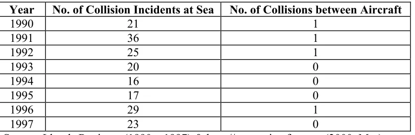
In the rules of the air, a submission of a flight plan is mandatory prior to operating any flight, including flights provided with air traffic control service, flights within or into designated areas, flights along designated routes and flights across international borders. Some of the key information submitted in the flight plans are estimated times at flight information region, cruising levels, cruising speed and route to be followed. Similarly, in a traffic organisation service provided by VTS, there is provision for the submission of a VTS sailing plan. Despite these similarities there are more collisions at sea than in the civil aviation. The statistics of collisions are shown in Table 1.
Table 1 – Statistics on Collisions
Year No. of Collision Incidents at Sea No. of Collisions between Aircraft
1990 21 1
1991 36 1
1992 25 1
1993 20 0
1994 16 0
1995 17 0
1996 29 1
1997 23 0
Most of the collisions at sea occurred near the coast or within the coastal waters. Critics argue that aircraft manoeuvres and ship manoeuvres are not similar. Aircraft have three-dimensional freedom of manoeuvres, while vessels are restricted to two-dimensional freedom of manoeuvres. The aircraft could turn left, right, increase or decrease its altitude and moreover the air space is invariably free of obstructions. Whereas, the vessel’s lateral movement is restricted due to close proximity of land, shoals and hazards.
Having noted the similarities between the rules of the air and sea, as well as the limitation and constraints, there are some areas in which maritime and port authorities could further improve to reduce the risks of maritime incidents. To address this, it is necessary to focus on how aviation authorities regulate and control air traffic so as to enhance the safety of air navigation without hampering freedom of passage.
3.3 Air Traffic Service
The ICAO (1978), International Standards and Recommended Practices for Air Traffic Service, pertains to the establishment of airspace, units and services necessary to promote a safe, orderly and expeditious flow of air traffic. These standards and practices have been established to ensure that flying on international air routes is carried out under uniform conditions designed to improve the safety and efficiency of air operation. The important aspect of these standards and recommended practices are that they not only apply to the airspace over the contracting State but also to airspace wherever the contracting State accepts the responsibility of providing air traffic services such as over the high seas or in space of undetermined sovereignty.
the safe and efficient conduct of navigation. The main difference between the ATS and VTS is that in civil aviation the contracting State must determine where the air traffic service will be provided, while for the coastal State, VTS is an option. It is also important to note that in civil aviation a State, by mutual agreement, may delegate to another State the responsibility for establishing and providing air traffic service extending over the territories of the former. It can be reasonably argued that air traffic service is a mandatory requirement imposed upon the contracting State.
3.4 Guidelines and Criteria for VTS
The IMO (1997b), Guidelines and Criteria for VTS, provides guidance to a coastal State or competent authority for the planning of VTS. The need to manage traffic should be carefully investigated and determined by analysing casualties, assessing risks and consulting local user groups. The guidelines further suggest that VTS is appropriate in areas where there exists high traffic density, traffic carrying hazardous cargoes, conflicting and complex navigational patterns, difficult hydrographical, hydrological and meteorological elements, a record of maritime casualties, etc.
Similarly, ICAO (1978), International Standards and Recommended Practices for Air Traffic Services, states that the need for air traffic service shall be determined by consideration of the types of air traffic involved, the density of air traffic, the meteorological conditions and such other factors as may be relevant. It also includes examples where there may be a need for air traffic services and one such example is that open stretches of water, mountainous, uninhabited or desert areas might necessitate the provision of air traffic services even though the amount or frequency of operation is extremely light.
almost every port in the world and straits used for international navigation can justify the establishment of a VTS. However, it is not mandatory for coastal States to provide VTS, and if provided it may only be made mandatory in sea areas within a State’s territorial waters. In civil aviation, aircraft enjoy freedom of passage too, but every international airport and civil aviation authority provides ATS to control and regulate air traffic within their airspace and up to the flight information region.
3.5 Guidelines on Qualification and Training of VTS Operators
There are more than 500 VTS systems in operation around the world and the services offered vary from a simple broadcast of navigational information to navigation related instructions. There are no formally recognised qualification, entry requirements and standards of training for VTS operators. IMO’s investigation confirmed that the entry requirements vary between countries ranging from personnel without nautical knowledge to personnel with certificate of competency or pilot’s licence. Also, recognised by IMO was that there was no fully defined standard of training to achieve the levels of knowledge and skill of the operators. This could be one of the reasons why shipmasters are reluctant to accept the advice of shore authorities to avoid an accident.
At the International Association of Lighthouse Authorities (IALA) (1996) symposium, it was concluded that international standards should be set for VTS personnel. VTS Authorities should also provide facilities for training to achieve these standards and institute measures to maintain it. IALA agreed to develop suitable training and certification standards.
VTS operators. These guidelines and framework laid the foundation for the IALA to develop a comprehensive document on standards for training and certification of VTS personnel. Also, IALA undertook to establish model courses for training and certification, guidance on the recruitment of VTS personnel and a model for operational job descriptions.
The IALA completed its recommendations on Standards for Training and Certification of VTS personnel and submitted the document, IALA (1998a), to the IMO, Maritime Safety Committee (MSC). Tremendous efforts have been made by IALA to expedite the recommendations for the training and certification of VTS personnel. Also, the high level of expertise from the members of VTS Committee contributed significantly in developing these standards.
These recommendations were well structured and duly recognised the importance of achieving a professional standard among VTS personnel globally, comparable to seafarers and maritime pilots. These covered every aspect of VTS personnel, categorising them as operators, supervisors, managers or instructors. There is also provision for proper selection and recruitment including aptitude and medical tests. The requirements for annual assessment and revalidation ensure that professional competency is continuously maintained. It is very similar to the code established in the IMO, International Convention on Standards of Training, Certification and Watchkeeping for Seafarers (STCW), as revised in 1995, stipulating clearly the requirements for competence; knowledge, understanding and proficiency; methods of demonstrating competence; and criteria for evaluating competence. In addition to these standards, IALA has now also completed the model courses for VTS operators and On-the-Job Training programme. The model course for VTS supervisors should be completed shortly.
certification are conceptually similar except for the functional differences. It is interesting to note that it is not a prerequisite to be a seafarer or an aircraft pilot to be trained as a VTS operator or an ATS controller.
The IMO, 72nd Session of the Maritime Safety Committee1 has approved to promulgate the IALA recommendations on Standards for Training and Certification of VTS Personnel through a circular to draw the attention of the VTS authorities. In author's opinion, it would have been much more appropriate, if these standards have been made mandatory and incorporated in the IMO, STCW. This would have ensured that VTS authorities complied with the standards and that there were sufficiently trained, qualified and competent personnel to manage the VTS. This would also have boosted the shipmasters confidence and enhanced the VTS operator and shipmaster relationship.
3.6 Legal Considerations – Relationship between ATC and Pilot Vs Relationship between VTS and Shipmaster
3.6.1 Relationship between ATC and Pilot
The Rules of the Air states that the pilot-in-command shall have final authority as to the disposition of the aircraft, and be responsible for the operation of the aircraft. However, in practise we know that aviation pilots comply with the instructions given by air traffic controllers (ATC).
Feedback obtained from air traffic controllers in Singapore indicates that the relationship between the ATC and the pilot is established by means of a flight plan. This flight plan is similar to a negotiated contract which binds the ATC and pilot. The pilot has a duty to maintain this plan unless he has valid reasons to depart from
it. In the event that the ATC considers at a certain point of time during the flight that the aircraft may encounter a close quarter situation, or the separation distances may be affected, he may propose a modified plan. The pilot may reject the plan but normally it is resolved rapidly by both parties agreeing to a satisfactory plan.
The role of the ATC is to monitor the flight, acknowledge pilots’ reports, and provide clearances for landing, taxiing, taking off, ascending and descending. The ATC may also accelerate or delay flights to maintain the necessary separation distance between any two planes. The ATC may also indicate the pre-determined procedures to achieve safety of aircraft, and pilots will normally follow these instructions. Discussion2 has confirmed that ATC issue instructions such as change of courses, speeds, heights or rates of descent to pilots when there is potential conflict between aircraft or when the separation passing distance between the aircraft would result closer than that stipulated. These instructions are given to aircraft flying within the controlled airspace and must be complied with by aircraft pilots. For example, Swedish and British ATCs carry out such positive controls and there are sufficient provisions in their regulations to take action against the pilots for any non-compliance. Therefore, it is the ATC that proposes the modified plan and pilot executes the desired course of actions.
The internationally recognised certification and training standards for air traffic controllers has fostered a good relationship between pilot and ATC in the discharge of their respective responsibilities. Moreover, under the ICAO (1978), States, which are parties, have a duty to provide air traffic services. Hence a very high standard of professionalism and competency of ATC is maintained by civil aviation authorities.
3.6.2 Relationship between VTS and Shipmaster
Strictly, the role of VTS is clearly defined as to provide information and advice. The shipmaster or pilot is responsible for the safe navigation of the vessel. The VTS has no authority to encroach or disturb the traditional relationship between master and pilot. It is traditionally accepted that the vessel’s manoeuvre shall be executed from the bridge of the vessel by the master or pilot. However, there are exceptions to such practices. In the Port of Rotterdam, during adverse weather, shore-based pilotage assistance, often called remote pilotage, is accepted by shipmasters who are entering harbour or proceeding to a suitable location to embark the pilot.
In the case of VTS, even if a VTS operator possess specialised knowledge, and is an experienced pilot or a master mariner with command experience and with local knowledge, his instructions are viewed as interfering with the traditional role of the master. At the author’s request a survey was conducted by PSA Marine pilots on vessels that call the Port of Singapore and frequently transit the Singapore Strait. A total of 20 shipmasters responded to the survey and without exception opposed VTS operators giving instructions regarding to ship manoeuvres. Shipmasters agreed that VTS had an overall picture of the traffic situation and with the latest updated information, VTS was in a better position than they were. However, the main concern of shipmasters in accepting the instructions from a VTS operator in close quarter situations were:
(a) the liability issues in the event of an accident; and
3.7 Legal Liability
The most important and controversial issue associated with the VTS system, is the liability aspect. Who is to be blamed when things go wrong? While the need for VTS, and the valuable contribution it makes to the safety of navigation, is recognised and accepted, the question of assignment of liability in the event of an accident is highly controversial.
The main debate is concentrated on, what is the extent of the liability of the VTS Authority when it is shown that the authority has been negligent or has committed an error. Basically, it is up to the authority to decide how much or how little liability it is prepared to accept for operations under its control. Although it has often been attempted, a State cannot legislate itself out of all liability3. In the event that an accident occurred due to instructions given by VTS operator, maritime laws of liability would be applicable. However, suits against governments are never easy. To avoid liability, VTS authorities are very clear in the types of service they provide. VTS operators do not provide instruction to shipmasters or pilots.
In civil aviation, although the pilot-in-command is responsible for the operation of aircraft, he complies with the instruction given by air traffic controller (ATC). Thus, a civil aviation authority, or other government authority or agency, which usually employs ATC is liable for civil action against negligent acts. In Australian National Airlines Commission v. The Commonwealth of Australia and Canadian Pacific Airlines4, the Australian High Court heard a case involving the
3 The HERMES [1969] 2 Lloyds Law Rep. 347 (Canada Exchequer Court), where the Conservancy Authority (the Crown) was unable to limit its liability owing to actual fault or privity with respect to damage and loss caused by misalignment of a leading light. The front light of a pair of leading lights had been moved by ice pressure over a period of years and the Conservancy Authority had failed either to undertake remedial action or to warn ships of the misleading character of the lights. As a consequence of this misalignment, the HERMES was close to the south bank of the channel. This caused a bank suction effect which resulted in HERMES sheering off-course and colliding with a ship proceeding in the opposite direction.
collision of two aircraft on a runway. The aircraft belonged to Australian National Airlines and Canadian Pacific Airlines, and the Commonwealth of Australia was the employer of the air traffic controller. The judge found that the airline pilots were equally at fault for the accident but that the air traffic controller was more at fault than either of the pilots. Each of the airlines was liable for 30% of the damages and the Commonwealth of Australia was liable for the remaining 40% of the damages.
In summary, there are many similarities between air traffic service and vessel traffic service. However, there are some areas in which maritime industry lack behind civil aviation. These should be addressed as follows:
(a) The standard for training and certification of VTS personnel should be made mandatory and included in the STCW to have an international standard so as to enhance the relationship between the VTS and Shipmaster;
(b) Pilots and ATCs have responsibilities for the safe navigation of aircraft. Therefore, the traditional law of the sea, recognising shipmaster as the sole judge of actions needed for the safety of his ship may no longer be valid;
(c) Civil aviation authorities are liable for the actions of their ATCs. Hence, IMO, IALA, VTS authorities, shipowners and shipping industry should work closely to establish a legal regime for VTS liability; and
Chapter 4
Development of Technology to Enhance Safety of Navigation
4.1 Modern Technology
The introduction of any new technology involves in overcoming major obstacles. Rapid advancement in technology, particularly in the areas of information technology, satellite navigation and telecommunications, has led to continuous improvement in navigational aids. Many navigational equipment and navigational aids have been developed to enhance safety, security, effectiveness and efficiency of maritime transportation. This chapter focuses on some of these technologies that would further enhance the safety of navigation when applied or used by ships and VTS. The functional capabilities and contributions to the safety of navigation including the limitations of the following navigational tools would be evaluated:
(a) Electronic Chart Display and Information System (ECDIS) (b) ENC data format
(c) Differential Global Positioning System & Global Navigational Satellite System – (DGPS & GLONASS)
(d) Automatic Identification System (AIS) transponders
4.2 Electronic Chart Display and Information System - ECDIS
contributes up to 80% of accidents at sea (Chua, N.F. 1999). The resultant of fatigue and illness, loss of concentration, workload and stress were the contributing factors to the human error. ECDIS could assist to reduce the navigational workload, improve safety and efficiency of shipboard operations.
The ECDIS is a powerful integrated navigational tool, designed primarily for use in confined and congested waters. It is a real-time geographic information system that is capable of integrating different navigational positioning systems and ship equipment with the electronic navigational chart (ENC). For example, when ship’s equipment such as radar and automatic radar plotting aid are superimposed on a single display system, it would provide position monitoring capabilities and collision avoidance detection. It has features to warn the mariners of any imminent danger so that they could have sufficient time to react. It enables mariners to do things that were previously not possible and also to do it safely, such as the use of low visibility transits in confined waters. The ECDIS also enables one mariner to pass on the knowledge to another. For example, navigational information pertaining to a certain voyages could be maintained and shared within the fleet from the ECDIS voyage information and passed on to other vessels for preview. Hence, sharing of this information would greatly increase the safety of future voyages undertaken by other vessels within the fleet.
(a) ISM and STCW requirements for passage planning were met in a more timely and cost efficient manner;
(b) Accurate, clear and constantly updated charts;
(c) Navigating with the pilot onboard could be properly monitored;
(d) Recorded information could be replayed later as a useful training aid; and (e) Integrated radar information.
However, some of the potential problems were the ability to delete data, reliability of information fed into the ECDIS, need to overcome the failure of the equipment whereby ships will not have charts to navigate and the importance of skill and proper training in ECDIS.
ECDIS not only benefits shipowners and navigators. It could also play an active role in shore-based navigational aids. At present VTS centres are changing from synthetic chart overlay to ECDIS to cover their areas of responsibility. In the near future VTS systems would make use of navigational safety broadcast services. In these so-called "Silent VTS systems", the location and movement of all vessels within the VTS area of responsibility would be broadcast as an overlay to a ship’s ECDIS display using a standard format and protocol. In addition, the VTS centres would also be able to send recommended or mandatory route changes to be displayed on the ship’s ECDIS and vice versa the ship could also transmit the planned route to VTS centres.
basis through the VTS system such as updating of charts, automated notices to mariners, weather warnings and ice coverage downloaded via digital links.
4.3 Electronic Navigational Chart (ENC) Data Format
The International Hydrographic Organisation (IHO) in Monaco maintains copies of charts issued by the member States. There are about over 20,000 different charts covering various regions and in different languages. The primary objective of IHO is to comment on variances on chart construction. IHO consistently works towards to achieve standardisation in the specifications, symbols, styles and formats used for nautical charts. These are governed by the Charts Specification of the IHO and Regulations of the IHO for International Charts. The biggest challenge to IHO is to develop a common, worldwide chart series that would be produced to a single set of agreed specifications for use by international shipping.
There is also a need for survey data to be charted on common datum. Currently, there are hundreds of different chart datums and this is a serious problem. Mariners had failed to realise that in the past as they approach a harbour or port, navigating visually or with regional navigational systems they had automatically shifted to the usage of local chart datum. However, the GPS navigation system is based on a World Geodetic System, 1984 (WGS-84) datum, and it is essential to adjust the GPS value to the local datum. Unfortunately, in many cases this correction to local datum is not known to all mariners. Given this backdrop, one can imagine the problem mariners would face, if the ENC data formats were also not standardised.
guide manufacturers. It should be noted that S57 Standards is a general transfer standard and not a display format. Hence, ENCs have to conform to the ENC product specification irrespective of their origin. Different ECDIS would work in different ways, however it is for the ECDIS manufacturer to translate the S57 Standards data to an internal format suitable to his equipment.
Due to the delays in providing the relevant international standards for ENC and the data, the use of electronic chart systems (ECS) using commercial data has increased over the past few years. ECS by definition is not intended to be a chart and it was difficult to ensure that they are not used. It was here that the raster chart display system (RCDS) entered the navigational arena and a number of hydrographic offices started producing them. Also, the unavoidable delay in extensive ENC coverage, there were calls for RCDS to be recognised officially in the absence of ENCs. RCDS has good track record and gathered positive reports from mariners. However, certain organisations are still opposed to the RCDS concept.
The “duel-fuel” philosophy was initiated by providing shared trials to fill up the gap or areas by RCDS where ENCs are not available. One such example is the trial between Singapore and Hong Kong and between ports in Europe. Participating vessels use ENCs in Singapore and Hong Kong and the official RCDS in Rotterdam, Felixstowe and its approaches. The ENCs by Singapore and Hong Kong are among the first to be produced that conform to the ENC product specification.
4.4 DGPS/DGLONASS
It can be simply stated that GPS is based on twenty-four satellites in six orbital paths that circles the earth twice each day at an inclination angle of approximately 55 degrees to the equator. This constellation of satellites continuously transmits coded positional and timing information at high frequencies in the 1500-Megahertz range. GPS receivers with antennas are located in positions to pick up these satellite signals and use the coded information to calculate a position in an earth co-ordinate system. GPS is the most accurate worldwide all-weather navigation system, but not free from errors. One of the significant errors in this system is the intentional degradation of the satellite signal by the DOD. This intentional degradation of the signal is known as selective availability (SA) and is intended to prevent adversaries from exploiting highly accurate GPS signals and using them against the United States or its allies. This error in conjunction with poor satellite geometry could limit GPS accuracy to 100 metres at 95% of the time and up to 300 metres at 5% of the time. Fortunately, this error could be reduced or eliminated through a technique known as "Differential."
Global Navigation Satellite System (GLONASS) is the Russian developed equivalent of the GPS. Its operation is similar to that of GPS System. The primary difference is that the satellite signals are not degraded by any form of selective availability (SA) and the system performance for civilian receivers will meet the requirement for horizontal position accuracy of + 45 metres at 95% of the time. The drawback of this system is that in the current Russian economic situation, the priority of maintenance is low and there are only 15 operational satellites out of a full constellation of 24 satellites. This results in the system having inadequate number of satellites to calculate vessel's position. GLONASS accuracy is not suitable for navigation in harbour entrances and confined water without augmentation. Also, it does not provide instantaneous warning of system malfunction. However, with the augmentation i.e. the application of differential correction, the Differential GLONASS (DGLONASS) can enhance the accuracy to + 10 metres at 95% of the time and offer integrity monitoring. Unfortunately, no similar differential processing techniques as that of DGPS has been made available for GLONASS. However, processing software is available for better accuracy of GLONASS.
DGPS when integrated with ECDIS can provide 24-hour real-time positioning to prevent grounding incidents. These features could be effectively used in confined waters like the Malacca and Singapore Straits and in ports, especially during periods of poor visibility like haze and night-time. DGPS is an essential navigational equipment which complements the use of ECDIS and provides continuous and accurate positions. In this respect, Maritime and Port Authority of Singapore (MPA) has set up facilities to broadcast differential corrections in October 1997. The DGPS corrections to be applied to receivers are transmitted in the medium frequency (MF) band on 298 kHz. These corrections are transmitted free of charge by MPA to the shipping community and the public. These corrections could be received at a distance of at least 200 km from Singapore.
4.5 Automatic Identification Systems (AIS)
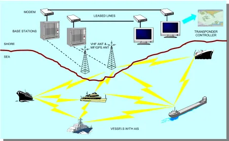
The VTS Committee of IALA including experts from IAPH, IAIN, IFSMA and IMPA undertook a study in 1988-1989 on the possible application of a transponder system which would permit ships to be identified and tracked when approaching, entering or sailing within a VTS area. An IALA (1990) paper outlining the requirements for ship identification, polling, tracking and automatic reporting system to operate in conjunction with VTS was submitted to the IMO Sub-Committee on Safety of Navigation. The initial focus was on ship-to-shore data exchange in support of vessel traffic management such as VTS. Subsequently, this transponder concept expanded to encompass the additional requirement for ship-to-ship data transfer to assist in collision avoidance. Hence, two VHF radio based transponder techniques emerged as follows:
(a) a transponder based on digital selective calling (DSC) protocols, using VHF channel 70; and
4.5.1 Digital Selective Calling System
The Digital Selective Calling (DSC) system was primarily utilised to provide a transponder to exchange data from ships to shore on VHF channels. These transponders supported the shore-based identification, tracking and monitoring of vessels. Interrogation or polling has to be performed when a ship enters the VTS area. This technology proved attractive to several nations, as VHF DSC channel 70 has been designated for Global Maritime Distress and Safety System (GMDSS). Most of the European nations, North America and Japan have chosen Area A1 and A2 under GMDSS implementation arrangements. Thus, all ships operating in these area and coastal stations would be fitted with VHF DSC equipment. Also, this type of transponder could be implemented relatively quickly. Several such systems have been implemented in United Kingdom and United States. For example, the monitoring of ferries crossing the Dover Straits by the Channel Navigation Information Services (CNIS) and the Valdez (Alaska) VTS.
However, drawbacks of these systems were that radar detection was still necessary to initiate polling process and VTS operator intervention is frequently required. The capacity for message to be transmitted on VHF channel 70 was limited and sharing of this channel limited the transponder's rate of update. Hence, the DSC transponder did not receive the final endorsement from IMO on the performance standards.
4.5.2 Universal Automatic Identification System
faster rate with the use of self-organising time division multiple access technology and ensured reliability during robust ship-to-ship operation. This system was also backward compatible with DSC systems, thus allowing shore-based GMDSS systems to establish AIS operating frequency channels, identify and track vessel equipped with AIS. A resolution, IMO (1998a) on the Recommendation on Performance Standards for an Universal AIS System was adopted at the IMO, 69th session of the Maritime Safety Committee in May 1998.
In busy waterways of harbours, ports, rivers, narrow channels and congested waters the continuous identification of vessels is essential for safety of navigation. Some of the benefits of AIS to shipmasters and VTS are as follows:
(a) Real-time tracking of own ship on ECDIS display with DGPS positions, course made good and speed made good;
(b) Presentation of predicted track when manoeuvring; (c) Data recording of vessels tracks;
(d) Able to receive DGPS corrections from base station;
(e) Continuous broadcast of own ship's dynamic, static and voyage related data to other ships and VTS centre;
(f) Send and receive short message to and from VTS and other ships;
(g) Non-existent of radar based tracker problems such as target swapping and degradation due to sea clutter and weather;
(h) Higher update rate of tracks compared to radar tracks;
(i) Extension of VTS surveillance beyond normal radar range in EEZ and for Search and Rescue operations;
(j) Reduction of voice communication; (k) Local navigational warnings; (l) Local aids to navigation status;
non-SOLAS vessel would not be required to be fitted with AIS. Many older non-SOLAS vessels will delay the installation of AIS, since there have been proposals to have provision in the SOLAS regulation for Administrations to exempt ships which will be taken permanently out of service within 2 years after the date of implementation. Hence, radar would remain the only detection and tracking system capable of handling all targets. Moreover, with the radar target broadcasting application, VTS radar would be retained. The radar target broadcasting is the process of converting radar targets to AIS targets and transmitting it to ships in the VTS area. This allows all ships fitted with AIS to view all targets held by VTS radar including targets from their own radar.
The use of AIS, as mentioned earlier, would reduce voice communication and minimise manual functions of VTS operators. However, it would still be necessary for exchange of information to vessels not fitted with AIS. Also, voice communication would be required in emergency situations and for immediate confirmation or acknowledgement when navigational assistance is provided.
4.5.3 Singapore's Experience in AIS Transponder Technology
A pilot test of the AIS transponder, known as Ship Identification and Positioning System (SIPS) was conducted in Singapore from April to June 1999. The objectives of this pilot test were to evaluate the applicability, suitability and the effectiveness of tracking of vessels in the port waters and Singapore Strait. The operational and technical performance of the AIS transponder was based on IMO's recommended performance standards.