Oracle as Spatial Database for Global
Information System (GIS) Application
Vibha H Mehta
Assistant Professor
Shree Swaminrayan College of Computer Science, Sardarnagar, Bhavnagar
Abstract
This paper explains the concepts of Oracle Spatial as a way to store and analyze spatial data. Oracle Spatial is designed to make spatial data management easier and more natural to users of location-enabled applications and Geographic Information System (GIS) applications. Once spatial data is stored in an Oracle database, it can be easily manipulated, retrieved. Moreover all other related data can also be stored in the database. The data that indicates the Earth location (such as longitude and latitude) of rendered objects is the spatial data. When the map is rendered, this spatial data is used to project the locations of the objects on a two-dimensional piece of paper. A GIS is often used to store, retrieve, and render this Earth relative spatial data. Types of spatial data (other than GIS data) that can be stored using Oracle Spatial include data from Computer Aided Design (CAD) and Computer Aided Manufacturing (CAM) systems.
Keywords: CAD, CAM, GIS, Oracle Spatial, Spatial Data, SDO_GEOMETRY, Topology
________________________________________________________________________________________________________
I. INTRODUCTION
Classical spatial database techniques use spatial data X and Y columns from various geometries, but this method allows only limited indexing and querying. Moreover the database access and data manipulation is difficult.
Oracle Spatial in Oracle Database10g includes native data types for storing vector, raster and persistent topology data. This document outlines some best practices when working with Oracle’s native vector data type, SDO_GEOMETRY in Oracle Spatial for Oracle Database 9i and 10g.
Some of the major GIS vendors have legacy proprietary alternatives to store vector data in Oracle, for example Oracle’s LONG RAW data type.
These legacy alternatives were introduced prior to the availability of the SDO_GEOMETRY data type. In the marketplace, there is sometimes the misconception that using SDO_GEOMETRY as the underlying vector data store may compromise features or performance in products offered by the major GIS vendors.
Oracle Spatial performance may far exceed 15% better performance over proprietary “LONG RAW” data type solutions[6]. This is because Oracle does not support table partitioning on tables that contain LONG or LONG RAW columns. Tables with SDO_GEOMETRY columns can leverage Oracle table partitioning, which can significantly help performance, scalability and manageability.
Most business information has a location component, such as Geo-coded customer addresses, sales territories and wireless service boundaries. Businesses can take advantage of their geographic information by incorporating location analysis into their information systems.
II. ORACLE SPATIAL
Oracle Spatial is an integrated set of functions and procedures that enables spatial data to be stored, accessed, and analyzed quickly and efficiently in an Oracle9i database.
Spatial data represents the essential location characteristics of real or conceptual objects as those objects relate to the real or conceptual space in which they exist.
Oracle Spatial provides a SQL schema and functions that facilitate the storage, retrieval, update and query of collections of spatial features in an Oracle database. Spatial consists of the following [3]:
1) The spatial component of a spatial feature is the geometric representation of its shape in some coordinate space. This is referred to as its geometry.
2) A schema (MDSYS) that prescribes the storage, syntax and semantics of supported geometric data types 3) A spatial indexing mechanism
4) Operators, functions, and procedures for performing area-of-interest queries, spatial join queries and other spatial analysis operations
Functions and procedures for utility and tuning operations
1) Topology data model for working with data about nodes, edges and faces in a topology
Geo-Raster, a feature that lets you store, index, query, analyze and deliver Geo-Raster data, that is, raster image and gridded data and its associated metadata
III. OBJECT RELATIONAL MODEL
Spatial supports the object-relational model for representing geometries. The object-relational model uses a table with a single column of MDSYS.SDO_GEOMETRY and a single row per geometry instance. The object-relational model corresponds to a "SQL with Geometry Types" implementation of spatial feature tables in the Open GIS ODBC/SQL specification for geospatial features.
The benefits provided by the object-relational model include:
Support for many geometry types, including arcs, circles, compound polygons, compound line strings and optimized rectangles
Ease of use in creating and maintaining indexes and in performing spatial queries Index maintenance by the Oracle9i database server
Geometries modeled in a single row and single column Optimal performance
IV. INTRODUCTION TO SPATIAL DATA
Oracle Spatial is designed to make spatial data management easier and more natural to users of location-enabled applications and Geographic Information System (GIS) applications. Once this data is stored in an Oracle database, it can be easily manipulated; retrieved and all other related data can be stored in the database.
A common example of spatial data can be seen in a road map. A road map is a two-dimensional object that contains points, lines and polygons that can represent cities, roads and political boundaries such as states or provinces. A road map is a visualization of geographic information. The location of cities, roads and political boundaries that exist on the surface of the Earth are projected onto a two-dimensional display or piece of paper, preserving the relative positions and relative distances of the rendered objects.
The data that indicates the Earth location (latitude and longitude, or height and depth) of these rendered objects is the spatial data. When the map is rendered, this spatial data is used to project the locations of the objects on a two-dimensional piece of paper. A GIS is often used to store, retrieve and render this Earth-relative spatial data.
Types of spatial data that can be stored using Spatial other than GIS data include data from computer-aided design (CAD) and computer-aided manufacturing (CAM) systems. Instead of operating on objects on a geographic scale, CAD/CAM systems work on a smaller scale, such as for an automobile engine or printed circuit boards.
The differences among these systems are only in the relative sizes of the data, not the data's complexity. The systems might not actually involve the same number of data points. On a geographic scale, the location of a bridge can vary by a few tenths of an inch without causing any noticeable problems to the road builders, whereas if the diameter of an engine’s pistons is off by a few tenths of an inch, the engine will not run. A printed circuit board is likely to have many thousands of objects etched on its surface that are no bigger than the smallest detail shown on a road builder's blueprints.
These applications all store, retrieve, update, or query some collection of features that have both non-spatial and spatial attributes. Examples of non-spatial attributes are name, soil type, land use classification, and Part number. The spatial attribute is a coordinate geometry, or vector-based representation of the shape of the feature.
V. GEOMETRY TYPES
Geometry is an ordered sequence of vertices that are connected by straight line segments or circular arcs. The semantics of the geometry are determined by its type. Spatial supports several primitive types and geometries composed of collections of these types, including 2-dimensional:
Points and point clusters Line strings
n-point polygons
Arc line strings (All arcs are generated as circular arcs.) Arc polygons
Compound polygons
Compound line strings Circles
Optimized rectangles
Self-crossing polygons are not supported, although self-crossing line strings are supported. If a line string crosses itself, it does not become a polygon. A self-crossing line string does not have any implied interior.
Fig. 1: Geometric Types
Examples:
Points can represent: buildings, fire hydrants, utility poles, oil rigs, boxcars, or roaming vehicles. Lines can represent: roads, railroad lines, utility lines, or fault lines.
Polygons can represent: cities, districts, flood plains, or oil and gas fields. A polygon with a hole might geographically represent a parcel of land surrounding a patch of wetlands.
VI. DATA MODEL
The Spatial data model is a hierarchical structure consisting of elements, geometries, and layers, which correspond to representations of spatial data. Layers are composed of geometries, which in turn are made up of elements.
For example, a point might represent a building location, a line string might represent a road or flight path, and a polygon might represent a state, city, zoning district, or city block.
Element
Anelement is the basic building block of geometry. The supported spatial element types are points, line strings, and polygons. For example, elements might model star constellations (point clusters), roads (line strings), and county boundaries (polygons). Each coordinate in an element is stored as an X, Y pair. The exterior ring and the interior ring of a polygon with holes are considered as two distinct elements that together make up a complex polygon.
Point data consists of one coordinate. Line data consists of two coordinates representing a line segment of the element. Polygon data consists of coordinate pair values, one vertex pair for each line segment of the polygon. Coordinates are defined in order around the polygon (counter clockwise for an exterior polygon ring, clockwise for an interior polygon ring).
Geometry
A geometry (or geometry object) is the representation of a spatial feature, modeled as an ordered set of primitive elements. Geometry can consist of a single element, which is an instance of one of the supported primitive types, or a homogeneous or heterogeneous collection of elements. A multi-polygon, such as one used to represent a set of islands, is a homogeneous collection. A heterogeneous collection is one in which the elements are of different types, for example, a point and a polygon.
An example of geometry might describe the buildable land in a town. This could be represented as a polygon with holes where water or zoning prevents construction.
Layer
A layer is a collection of geometries having the same attribute set. For example, one layer in a GIS might include topographical features, while another describes population density, and a third describes the network of roads and bridges in the area (lines and points). Each layer's geometries and associated spatial index are stored in the database in standard tables.
Coordinate System
Any spatial data has a coordinate system associated with it. The coordinate system can be geo-referenced (related to a specific representation of the Earth) or not geo-referenced (that is, Cartesian and not related to a specific representation of the Earth). If the coordinate system is geo-referenced, it has a default unit of measurement (such as meters) associated with it, but you can have Spatial automatically return results in another specified unit (such as miles).
Before Oracle Spatial release 8.1.6, geometries (objects of type SDO_GEOMETRY) were stored as strings of coordinates without reference to any specific coordinate system. Spatial functions and operators always assumed a coordinate system that had the properties of an orthogonal Cartesian system, and sometimes did not provide correct results if Earth-based geometries were stored in latitude and longitude coordinates. With release 8.1.6, Spatial provided support for many different coordinate systems, and for converting data freely between different coordinate systems.
Spatial data can be associated with a Cartesian, geodetic (geographical), projected, or local coordinate system:
Cartesian coordinates are coordinates that measure the position of a point from a defined origin along axes that are perpendicular in the represented two-dimensional or three-dimensional space.
If a coordinate system is not explicitly associated with geometry, a Cartesian coordinate system is assumed.
Geodetic coordinates (sometimes called geographic coordinates) are angular coordinates (longitude and latitude), closely related to spherical polar coordinates, and are defined relative to a particular Earth geodetic datum. (A geodetic datum is a means of representing the figure of the Earth and is the reference for the system of geodetic coordinates.)
Projected coordinates are planar Cartesian coordinates that result from performing a mathematical mapping from a point on the Earth's surface to a plane. There are many such mathematical mappings, each used for a particular purpose.
Local coordinates are Cartesian coordinates in a non-Earth (non-geo-referenced) coordinate system. Local coordinate systems are often used for CAD applications and local surveys.
When performing operations on geometries, Spatial uses either a Cartesian or curvilinear computational model, as appropriate for the coordinate system associated with the spatial data.
Tolerance
Tolerance is used to associate a level of precision with spatial data. Tolerance reflects the distance that two points can be apart and still be considered the same (for example, to accommodate rounding errors). The tolerance value must be a non-negative number greater than zero. The significance of the value depends on whether or not the spatial data is associated with a geodetic coordinate system.
For geodetic data (such as data identified by longitude and latitude coordinates), the tolerance value is a number of meters. For example, a tolerance value of 100 indicates a tolerance of 100 meters.
For non-geodetic data, the tolerance value is a number of the units that are associated with the coordinate system associated with the data. For example, if the unit of measurement is miles, a tolerance value of 0.005 indicates a tolerance of 0.005 (that is, 1/200) mile (approximately 105 feet), and a tolerance value of 2 indicates a tolerance of two miles.
In both cases, the smaller the tolerance value, the more precision is to be associated with the data. A tolerance value is specified in two cases:
In the geometry metadata definition for a layer As an optional input parameter to certain functions
VII. DATABASE OBJECTS
The object-relational implementation of Oracle Spatial consists of a set of object data types, type methods, operators, functions and procedures that use these types. Geometry is stored as an object, in a single row, in a column of type SDO_GEOMETRY. Spatial index creation and maintenance is done using basic DDL (CREATE, ALTER, DROP) and DML (INSERT, UPDATE, DELETE) statements.
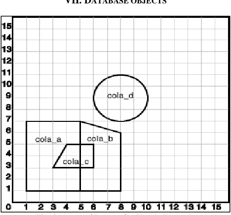
The scenario is a soft drink manufacturer that has identified geographical areas of marketing interest for several products (colas). The colas could be those produced by the company or by its competitors, or some combination. Each area of interest could represent any user-defined criterion: for example, an area where that cola has the majority markets share, or where the cola is under competitive pressure, or where the cola is believed to have significant growth potential. Each area could be a neighborhood in a city, or a part of a state, province, or country.
Figure 2 performs the following operations:
Creates a table (COLA_MARKETS) to hold the spatial data
Inserts rows for four areas of interest (cola_a, cola_b, cola_c, cola_d)
Updates the USER_SDO_GEOM_METADATA view to reflect the dimensional information for the areas Creates a spatial index (COLA_SPATIAL_IDX)
Performs some spatial queries.
Creating, Inserting, Indexing, and Querying Spatial Data
Create a table for cola (soft drink) markets in a given geography (such as city or state). Each row will be an area of interest for a specific cola (for example, where the cola is most preferred by residents, where the manufacturer believes the cola has growth potential, and so on)
CREATE TABLE cola_markets (mkt_id NUMBER PRIMARY KEY, name VARCHAR2(32), shape MDSYS. SDO_GEOMETRY);
INSERT statement creates an area of interest for Cola A. This area happens to be a rectangle. The area could represent any user-defined criterion: for example, where Cola A is the preferred drink, where Cola A is under competitive pressure, where Cola A has strong growth potential, and so on.
INSERT INTO cola_markets VALUES (1, 'cola_a', MDSYS.SDO_GEOMETRY( 2003, -- 2-dimensional polygon
NULL, NULL, MDSYS.SDO_ELEM_INFO_ARRAY(1,1003,3), -- one rectangle (1003 = exterior)
MDSYS.SDO_ORDINATE_ARRAY(1,1, 5,7) -- only 2 points needed to define rectangle (lower left and upper right) with Cartesian-coordinate data
) );
The next two INSERT statements create areas of interest for Cola B and Cola C. These areas are simple polygons (but not rectangles).
INSERT INTO cola_markets VALUES (2, 'cola_b',
MDSYS.SDO_GEOMETRY( 2003, -- 2-dimensional polygon NULL,NULL,
MDSYS.SDO_ELEM_INFO_ARRAY(1,1003,1), -- one polygon (exterior polygon ring) MDSYS.SDO_ORDINATE_ARRAY(5,1, 8,1, 8,6, 5,7, 5,1))
);
INSERT INTO cola_markets VALUES (3, 'cola_c',
MDSYS.SDO_GEOMETRY( 2003, -- 2-dimensional polygon NULL,NULL,
MDSYS.SDO_ELEM_INFO_ARRAY(1,1003,1), -- one polygon (exterior polygon ring) MDSYS.SDO_ORDINATE_ARRAY(3,3, 6,3, 6,5, 4,5, 3,3)
) );
Now insert an area of interest for Cola D. This is a circle with a radius of 2. It is completely outside the first three areas of interest.
INSERT INTO cola_markets VALUES (4, 'cola_d',
MDSYS.SDO_GEOMETRY( 2003, -- 2-dimensional polygon
MDSYS.SDO_ORDINATE_ARRAY(8,7, 10,9, 8,11) )
);
CREATE THE SPATIAL INDEX CREATE INDEX cola_spatial_idx ON cola_markets(shape)
INDEXTYPE IS MDSYS.SPATIAL_INDEX; Preceding created an R-tree index Following line was for an earlier Quad tree index:
PARAMETERS('SDO_LEVEL = 8');
Example of Some Spatial Queries
Return the topological intersection of two geometries
.
SELECT
SDO_GEOM.SDO_INTERSECTION (c_a.shape, c_c.shape, 0.005)
FROM cola_markets c_a, cola_markets c_c WHERE c_a.name = 'cola_a' AND c_c.name = 'cola_c';
Do two geometries have any spatial relationship?
SELECT SDO_GEOM.RELATE(c_b.shape, 'anyinteract', c_d.shape, 0.005)
FROM cola_markets c_b, cola_markets c_d WHERE c_b.name = 'cola_b' AND c_d.name = 'cola_d';
Return the areas of all cola markets.
SELECT name, SDO_GEOM.SDO_AREA(shape, 0.005) FROM cola_markets;
Return the area of just cola_a.
SELECT c.name, SDO_GEOM.SDO_AREA(c.shape, 0.005) FROM cola_markets c WHERE c.name = 'cola_a';
Return the distance between two geometries.
SELECT SDO_GEOM.SDO_DISTANCE(c_b.shape, c_d.shape, 0.005) FROM cola_markets c_b, cola_markets c_d WHERE c_b.name = 'cola_b' AND c_d.name = 'cola_d';
Is a geometry valid?
SELECT c.name, SDO_GEOM.VALIDATE_GEOMETRY_WITH_CONTEXT(c.shape, 0.005) FROM cola_markets c WHERE c.name = 'cola_c';
VIII. CONCLUSION
Oracle Spatial makes it possible to combine the relational power of a database with spatial data. The ability to use indexes, various queries, and functions means complex spatial calculations may be pushed back onto large database servers. As mobile applications and technologies increase, so will the demands to store and analyze spatial data in a transactional setting. Oracle Spatial are powerful core features of the Oracle database.
For complex GIS applications Oracle Spatial provides the required functionality, like spatial functions (including area, buffer, centroid calculations), advanced coordinate systems support, linear referencing systems, and aggregate functions.
Oracle Spatial provides performance, ease of use, and an architecture that scales to meet the needs of Internet and wireless solutions.
This technical document describes some best practices, tips and general information that can help utilize Oracle Spatial to increase productivity, decision support, and cost savings in your everyday business practices.
REFERENCES
[1] B. Hall, Oracle Spatial and Database Tuning, Oklahoma, 2007
[2] R. Kothuri, A. Godfrind, Pro Oracle Spatial for Oracle Database, Hardcover 2007
[3] K.Loney, G.Kock, Oracle Database 10G – The Complete Reference, Oracle Press , Osborne 2004
[4] R. Kothuri, E. Beinat, A.Godfrind, Pro Oracle Spatial, Apress L. P. Hardcover, Nov. 2004
[5] M. Bauer, Mapping Geometric Data with Oracle Spatial, O'Reilly Network, Nov. 2003
[6] D. Geringer, Oracle Spatial Best Practices, Oracle Press , Osborne 2003

![Full text and summary of a speech [on international trade in textiles] by the Rt. Hon. Sir Christopher Soames, Vice-President of the Commission of the European Communities in charge of external trade relations, to the International Federation of Cotton an](data:image/gif;base64,R0lGODlhAQABAIAAAP///wAAACH5BAEAAAAALAAAAAABAAEAAAICRAEAOw==)