ORDINANCE NO. 2001-076
AN ORDINANCE OF THE COUNTY OF SARASOTA, FLORIDA, PROVIDING FOR THE AMENDMENT (NO. RMA-1) OF THE SARASOTA COUNTY COMPREHENSIVE PLAN AS ADOPTED BY SARASOTA COUNTY ORDINANCE NO. 89-18, AS AMENDED; PROVIDING FOR FINDINGS; PROVIDING FOR DEFINITIONS; AMENDING THE FUTURE LAND USE CHAPTER BY ADDING THE SARASOTA 2050 RESOURCE MANAGEMENT AREA (RMA) SYSTEM HAVING COUNTYWIDE APPLICATION; AMENDING OTHER PROVISIONS OF THE COMPREHENSIVE PLAN AS REQUIRED TO IMPLEMENT THE RMA SYSTEM COUNTYWIDE, INCLUDING GOALS, OBJECTIVES, POLICIES AND OTHER PRIMARY COMPONENTS, AS WELL AS GUIDING PRINCIPLES AND SUPPORT MATERIAL; PROVIDING FOR INTERPRETATION; PROVIDING FOR EFFECT ON OTHER ORDINANCES AND REGULATIONS; PROVIDING FOR SEVERABILITY; AND PROVIDING AN EFFECTIVE DATE.
BE IT ORDAINED BY THE BOARD OF COUNTY COMMISSIONERS OF SARASOTA COUNTY, FLORIDA:
Section 1. Findings. The Board of County Commissioners hereby makes the following findings: (a) Pursuant to Article VIII, Section 1(g) of the Constitution of the State of Florida, the Sarasota County Home Rule Charter, and the Local Government Comprehensive Planning and Land Development Regulation Act, Chapter 163, Part II, Florida Statutes, as amended, (the Act), Sarasota County is authorized and required to adopt a comprehensive plan.
(b) Sarasota County Ordinance No. 76-51, as amended, and as codified in Section 94-61 of the Sarasota County Code, designated the Sarasota County Planning Commission as the Local Planning Agency and provided for the preparation and recommendation of a comprehensive plan and amendments thereto by the Sarasota County Planning Commission and the adoption of a comprehensive plan and amendments thereto by the Board of County Commissioners in accordance with the provisions of the Act. (c) The Sarasota County Planning Commission held a public hearing with due public notice on October 3, October 10, November 8, November 14, November 27, and November 29, 2001, for an amendment (RMA-1) of the Future Land Use Chapter of Apoxsee: The Sarasota County Comprehensive Plan, adopted by Sarasota County Ordinance No. 89-18, as amended, and transmitted its recommendation for approval of comprehensive plan amendment (RMA-1) on November 30, 2001 to the Board of County
public hearing on January 29, January 30, January 31, February 4, and February 15, 2002, to receive public comment on the proposed amendment to Apoxsee: The Sarasota County Comprehensive Plan. (e) On February 15, 2002, the Board of County Commissioners of Sarasota County approved the transmittal of the proposed amendment (RMA-1) to state, regional and local agencies for review and comment.
(f) Said proposed amendment as approved for transmittal by the Board of County Commissioners of Sarasota County, together with supporting documentation, was transmitted to the Florida Department of Community Affairs, the Florida Department of Environmental Protection, the Florida Department of Transportation, the Southwest Florida Regional Planning Council, the Southwest Florida Water Management District, and any other entity of local government or governmental agency in the State of Florida that had filed with the Board of County Commissioners a request for copies of all proposed comprehensive plans or elements or portions thereof, for review and comment in accordance with the provisions of the Act and Rule 9J-11.006, F.A.C.
(g) The Florida Department of Community Affairs reviewed the proposed plan amendment (RMA-1) for consistency with Chapter 163, Florida Statutes, and Rule 9J-5, Florida Administrative Code, and raised objections, recommendations, or comments.
(h) The Board of County Commissioners of Sarasota County held a duly advertised adoption stage public hearing on June 24, June 25, July 1, and July 10, 2002, to receive public comment on the proposed amendment to Apoxsee: The Sarasota County Comprehensive Plan.
Section 2. Definitions. For the purpose of this Ordinance, the following definitions shall apply: (a) "Act" means the Local Government Comprehensive Planning and Land Development Regulation Act, Chapter 163, Part II, Florida Statutes, as amended.
(b) Apoxsee: The Sarasota County Comprehensive Plan means the document adopted by the Board of County Commissioners and filed with the Clerk of said Board pursuant to Sarasota County Ordinance No. 89-18, as amended.
(c) "Board" means the Board of County Commissioners of Sarasota County, Florida.
Section 3. Adoption of Amendment RMA-1 to Apoxsee: The Sarasota County Comprehensive Plan. The Board of County Commissioners of Sarasota County hereby adopts Amendment RMA-1 to Apoxsee: The Sarasota County Comprehensive Plan pursuant to and in compliance with the Local
Section 4. Interpretation.
(a) The language and provisions of this ordinance and Apoxsee: The Sarasota County Comprehensive Plan shall be construed in pari materia with Chapter 163, Part II, Florida Statutes, and Chapter 9J-5, Florida Administrative Code.
(b) Except where specifically indicated to the contrary, where any provision of this Ordinance refers to or incorporates another provision, ordinance, statute, code, regulation, or other authority, it refers to the most current version of the other provision, ordinance, statute, code, regulation, or other authority, including any subsequent amendments thereto or renumbering thereof.
Section 5. Effect on Other Ordinances. Where this Ordinance conflicts with another County ordinance, the provisions of this ordinance shall prevail to the extent of such conflict except as otherwise provided herein.
Section 6. Severability. It is declared to be the intent of the Board that if any provision of this Ordinance is for any reason finally held invalid or unconstitutional by any court of competent jurisdiction, such provision shall be deemed a separate, distinct and independent provision and such holding shall not affect the validity of the remaining provisions.
Section 7. Effective Date. The effective date of this plan amendment shall be the date a final order is issued by the Department of Community Affairs or Administration Commission finding the amendment in compliance in accordance with Section 163.3184(1)(b), Florida Statutes.
PASSED AND DULY ADOPTED BY THE BOARD OF COUNTY COMMISSIONERS OF SARASOTA COUNTY, FLORIDA, this 10th day of July 2002.
BOARD OF COUNTY COMMISSIONERS OF SARASOTA COUNTY, FLORIDA
By: ______________________________ Nora Patterson
Chairman ATTEST:
of Sarasota County, Florida
By: ________________________________ Deputy Clerk
Exhibit A
Of
The Board of County Commissioners of Sarasota County
Ordinance No. 2001-076 Adopted July 10, 2002
SARASOTA 2050
RESOURCE MANAGEMENT AREA (RMA) SYSTEM
COMPREHENSIVE PLAN AMENDMENT RMA-1
Sarasota 2050 Resource Management Area (RMA) System
Index
GOAL, OBJECTIVES AND POLICIES
Chapter Page
Urban/Suburban Resource Management Area ...9 RMA-4 Economic Development Resource Management Area ...9 RMA-11 Rural Heritage/Estate Resource Management Area ...9 RMA-17 Village/Open Space Resource Management Area ...9 RMA-18 Greenway Resource Management Area...9 RMA-42 Agricultural Reserve Resource Management Area...9 RMA-47 Transfer of Development Rights Program (Density Incentives Program) ...9 RMA-48 RMA Definitions ...9 RMA-58
TABLES
Chapter Page
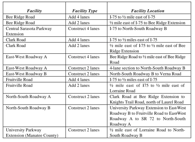
Table RMA-1 Future Road Capital Improvements...9 RMA-59 Table RMA-2 Transfer of Development Rights (TDR) Sending and Receiving Zones...9 RMA-60
FIGURES
Chapter Page
Figure VOS-1: Example of Village Concept...9 RMA-66 Figure VOS-2: Example of Hamlet Concept ...9 RMA-67 Figure VOS-3: Examples of Minimum Buffer Requirements...9 RMA-68 Figure VOS-4: Examples of Greenway RMA Edge Treatment ...9 RMA-69 Figure RMA-1 Resource Management Area Map ...9 RMA-70 Figure RMA-2 Sarasota 2050 Structure Graphic ...9 RMA-71 Figure RMA-3 Village/Open Space RMA Land Use Map...9 RMA-72
SARASOTA COUNTY RESOURCE
MANAGEMENT AREAS
GOAL, OBJECTIVES AND POLICIES
The Sarasota County Resource Management Area (RMA) Goal, Objectives and Policies are designed as a supplement to the Future Land Use Chapter of APOXSEE. The RMAs function as an overlay to the adopted Future Land Use Map and do not affect any existing rights of property owners to develop their property as permitted under the Comprehensive Plan, the Zoning Ordinance or the Land Development Regulations of Sarasota County or previously approved development orders; provided, however, that Policy TDR2.2 shall apply to land located within the Rural/Heritage Estate, Village/Open Space, Greenway and Agricultural Reserve RMAs where an increase in residential density is sought.Goal: Establish a development policy framework that enhances the livability of the County and preserves its natural, cultural, physical and other resources, by creating a Resource Management Area (RMA) system that addresses development issues within six unique resource areas: • Urban/Suburban • Economic Development • Rural Heritage/Estate • Village/Open Space • Greenway • Agricultural Reserve
This framework was created to implement the Organizing Concepts and Principles of Directions for the Future, Resolution 2000-230, adopted October 10, 2000.
Objective RMA 1: To create an incentive-based structure that will
enhance the livability of Sarasota County and
preserve its natural, cultural, and physical
resources.
Policy RMA1.1 Resource Management Area Ideals (RMA Ideals)
The Resource Management Area Map, depicted in Figure RMA-1, is an overlay to the Sarasota County Future Land Use Map. The Resource Management Areas are designed to:
• Preserve and strengthen existing communities
• Provide for a variety of land uses and lifestyles to support residents of diverse ages, incomes, and family sizes, including housing that is affordable to residents at or below the median income for Sarasota County
• Preserve environmental systems
• Direct population growth away from floodplains
• Avoid Urban Sprawl
• Reduce automobile trips
• Create efficiency in planning and provision of infrastructure
• Provide County central utilities
• Conserve water and energy
• Allocate development costs appropriately
• Preserve rural character, including opportunities for agriculture
• Balance jobs with housing
The additional development opportunities afforded by the Sarasota 2050 Resource Management Area Goal, Objectives and Policies are provided on the condition that they are implemented and can be enforced as an entire package. For example, the densities and intensities of land use made available by the Sarasota 2050 Resource Management Area Goal, Objectives and Policies may not be approved for use outside the policy framework and implementing regulatory framework setforth herein.
Policy RMA1.2 Sarasota 2050 Structure Graphic
The concepts that demonstrate the ideals of the Resource Management Areas are illustrated in Figure RMA-2, Sarasota 2050 Structure Graphic, and represent the long-term vision of the County’s development and resource protection. The Structure Graphic provides no regulatory function within the Comprehensive Plan.
Policy RMA1.3 Relationship to Existing Goals, Objectives and Policies
The Sarasota 2050 Resource Management Area Goal, Objectives and Policies shall not affect the existing rights of property owners to develop their property as permitted under the Comprehensive Plan, the Zoning Ordinance, the Land Development Regulations or previously approved
development orders; provided, however, that Policy TDR 2.2 shall apply to land located within the Rural Heritage/Estate, Village/Open Space, Greenway and Agricultural Reserve RMAs where an increase in residential density is sought. If a property owner chooses to take advantage of the incentives provided by the Sarasota 2050 RMA, then to the extent that there may be a conflict between the Sarasota 2050 Resource Management Area Goal, Objectives and Policies and the other Goal, Objectives and Policies of APOXSEE, the Sarasota 2050 Resource Management Area Goal, Objectives and Policies shall take precedence. The other Goals, Objectives and Policies of APOXSEE including, but not limited to, those which relate to concurrency management and environmental protection shall continue to be effective after the adoption of these Resource Management Area Goal, Objectives and Policies.
The Urban/Suburban RMA as depicted in Figure RMA-1, Resource Management Area Map, functions as an overlay for the Urban Service Area and provides a framework for community-building activities. These activities include a Neighborhood Planning Program, implementation strategies and design guidelines.
Objective US1: To protect and enhance Neighborhoods and historic
communities through the establishment of a
Neighborhood Planning Program.
Policy US1.1 Neighborhood Planning Program
The County shall establish a Neighborhood Planning Program that is designed to address existing Neighborhood issues, improve Neighborhood infrastructure and enhance the quality of the housing stock through renovations, replacement and maintenance.
Policy US1.2 Neighborhood Planning Process
The County shall formalize a process for Neighborhood planning that is based upon a high degree of citizen participation throughout the process and includes the following components:
• Delineate the Neighborhood planning area. In addition to the residential area, the delineation of Neighborhood planning area boundaries shall include the local shops and businesses that serve the area, and public facilities such as parks and schools;
• Promote existing Neighborhood organizations;
• Prepare a Neighborhood plan;
• Establish a financial strategy for the operation and maintenance of infrastructure; and
• Establish a communication plan for public involvement.
Policy US1.3 Neighborhood Plan Components
At a minimum, Neighborhood plans shall include the following components:
• Delineation of Neighborhood planning area;
• Definition of community character through sketches and photos;
• Review of land use and density ranges for consistency with community character;
• Identification of existing Neighborhood issues or problems;
• Assessment of Neighborhood features including sidewalks, street lights, street trees, direction and safety signs and other design features;
• Assessment of infrastructure including transportation and traffic calming opportunities, availability of recreation and Open Space, public utilities;
• Provide access to parks, schools, and shopping; and
• Design standards for housing and Neighborhood facilities. The County shall evaluate, by July 10, 2003, additional mechanisms that are designed to improve the visual and functional quality of Neighborhoods. At a minimum the County will evaluate funding, including a matching grants program for Neighborhood improvements and the provision of street trees.
Policy US1.4 Neighborhood Plans
Neighborhood plans may be prepared by the County or they may be initiated and prepared by residents. As a part of the Neighborhood planning process, the County shall develop guidelines or criteria for prioritizing Neighborhood requests for planning assistance.
Policy US1.5 Neighborhood Design Philosophy
Each Neighborhood plan shall include specific Neighborhood design standards that will sustain and enhance the character of the Neighborhood and which are based upon the following principles:
• Neighborhoods should be designed to establish an identity and value that motivates residents to protect them;
• Neighborhood streets should be designed as Open Spaces for pedestrians that connect to adjacent uses and Neighborhood supporting businesses without encouraging cut-through traffic;
• Common open areas should be part of every Neighborhood with easily and safely accessible Neighborhood parks; and
• Landscaping, lighting and signs should be used to create community identity and pride.
Objective US2:
To ensure that sufficient resources are available to
support and sustain existing and future
Neighborhoods.
Policy US2.1 Neighborhood Planning Resource Program
The County shall provide information resources for citizen-based Neighborhood planning efforts through publications, seminars and the County’s website. This information will include examples and ideas about the planning for successful Neighborhoods.
Policy US2.2 Infrastructure Assessment and Improvements
The County shall prepare a conceptual framework for the Urban Service Area (USA) that generally describes the County’s vision for the provision of urban services. This framework shall include central water and sewer utilities, master stormwater management systems, fire protection, Neighborhood parks, and street facilities such as lights, sidewalks, and trees and will address financing options and opportunities.
Policy US2.3 Neighborhood Revitalization
The County shall evaluate within one year of the effective date of the Sarasota 2050 RMA-1 Comprehensive Plan amendment the effect of the current Zoning Ordinance, Land Development Regulations and building codes on re-construction and revitalization efforts and identify areas where alternative regulations can support reconstruction, while continuing to ensure the health and safety of the citizenry. Such alternative regulations may provide for accessory living units and live/work units.
Policy US2.4 Neighborhood Assistance
The County shall evaluate by July 10, 2003, the feasibility of further expanding the current Community Development Block Grant, Home Investment Partnerships Program (HOME) and State Housing Initiative Partnership (SHIP) programs in Neighborhoods.
Policy US2.5 Priority Spending Areas
In order to support and sustain existing Neighborhoods and economic development areas, Sarasota County shall target its resources into Priority Spending Areas. Priority Spending Areas shall be within the Urban Service Area and may consist of:
• Areas within the Urban/Suburban RMA in which a Neighborhood, Community, Revitalization or Critical Area Plan has been completed;
• Areas within the Economic Development RMA for which a development plan as described in Policy ED1.2 has been adopted;
• Projects or programs that overcome existing infrastructure deficiencies; and
• Projects or programs that improve overall systems such as transportation.
Objective US3:
To encourage infill development within the Urban
Service Area.
Policy US3.1 Development Review Process
The County shall establish an expedited staff review and scheduling of rezoning and development review process within two years of the effective date of the Sarasota 2050 RMA-1 Comprehensive Plan amendment for priority development review and permitting for infill development and for the priority review of redevelopment or rehabilitation of structures and infrastructure.
Objective US4:
To encourage development that enhances the
livability of the Future Urban Area and is compact and pedestrian
friendly and preserves the Greenways and significant areas of Open
Space.
Policy US4.1 Incentives for Development Within Urban/Suburban Settlement Areas
The County shall support development within the Urban/Suburban Settlement Area (Settlement Area) of the Future Urban Area that generally conforms to the development pattern and design goals of the Village/Open Space RMA as established below. This Settlement Area is established to allow development of a maximum of 4000 dwelling units provided that such development conforms to the principles established in Policy US4.2. Future Land Use Chapter Policies 2.3.1 and 3.1.6 may be superseded by this policy when a specific property demonstrates through the rezoning and master development plan process established for the Urban/Suburban RMA that the timing of development within the Future Urban Area is appropriate based upon the following:
• That the proposed Urban Suburban Settlement (Settlement) development generally conforms to the Village/Open Space RMA policies of Objectives VOS1, VOS2, VOS3, and VOS4, as they apply to the Village land use category, including but not limited to Fiscal Neutrality. The minimum Open Space requirement of 50% (Policy VOS1.2.a.) may be reduced to a minimum of 33% by the Board of County Commissioners for a Master Development Plan in the Settlement Area that does not include a golf course as part of the Open Space.
• That adequate public facilities and services will be available to accommodate the development and maintain the adopted level of service standards.
• To achieve the minimum residential density required for Settlement development of 3 dwelling units per Gross Developable Acre, density transfer credits shall be transferred from the Greenway RMA and from the required Open Space on site to the Developed Area. The property will be entitled to develop a maximum of two dwelling units per gross acre if these units are transferred into the Developed Area in accordance with an approved Master Development Plan. Additional dwelling units may be developed if transferred from the Greenway RMA.
Policy US4.2 Settlement Principles
Development within the Settlement Area will be based on standards that generally conform to those established for Village development within the Village/Open Space RMA, but which recognize the close proximity of non-residential uses and which recognize that urban residential development is adjacent to the Settlement Area.
Development within the Settlement Area of the Urban/Suburban RMA shall exhibit the following characteristics:
• Neighborhoods form the basic building block for development, characterized by a mix of residential housing types that are distributed on a connected street system where the majority of housing is within a walking distance or ¼ mile radius of a Neighborhood Center;
• Neighborhood Centers will have a Public/Civic focal point which may be a combination of schools, parks, and public facilities such as places of worship or community centers, and may include small scale Neighborhood-oriented retail uses having no greater than 20,000 gross square feet of floor area;
• A mix of uses, including residential, commercial, office, Public/Civic, schools, and Recreational Space, that provides for most of the daily needs of residents shall be located within the Settlement, or within a maximum of 5 miles of each Neighborhood Center, and shall be accessible to all residents of the Settlement;
• Preservation of the Greenway RMA, and preservation of Open Space in perpetuity;
• A range of housing types that support a broad range of family sizes and incomes;
• A compact design that includes a system of land subdivision and development which links one Neighborhood to another;
• Interconnected streets that are designed to balance the needs of all users, including pedestrians, bicyclists and motor vehicles, and which are built with design speeds that are appropriate for Neighborhoods;
• Alternatives for pedestrians and bicyclists through the provision of sidewalks, street trees and on-street parking which provide distinct separation between pedestrians and traffic, spatially define streets and sidewalks by arranging buildings in a regular pattern that are unbroken by parking lots; and provide adequate lighting that is designed for safe walking and signage which has a pedestrian orientation;
• A system of interconnected streets that provides local public road connections between all adjacent parcels, and that is designed to discourage, and provide alternatives to, the use of the arterial roadway system;
• Open Space outside the Developed Area of each Settlement is required to support the environmental goals of this Plan by preserving important environmental features, connections and functions on site. Such Open Spaces shall be permanently protected through appropriate legal instruments and a Management and Maintenance Plan which shall be submitted as part of a Master Development Plan; and
• Recreational Spaces are to meet the recreational needs of each Settlement, reinforce the design of the development by providing a variety of amenities that serve a range of interests and distribute recreational amenities throughout the Settlements.
Policy US4.3 Land Development Regulations and Master Development Plan Requirements
Development activity that is designed as a Settlement within the Settlement Area shall be rezoned to a planned unit development-type zoning district
and shall be planned through a master development plan process that generally conforms to Policy VOS2.4. The County shall adopt amendments to the Zoning Ordinance and Land Development Regulations to establish the specific requirements for developments within the Settlement Area to ensure consistency with the Urban/Suburban Settlement Principles (Policy US4.2). The Zoning Ordinance will include the development of a new planned unit development-type zoning district that will implement the Settlement Area future land use designation. An update of the actual number of new dwelling units approved within each Settlement that remain to be constructed shall be included as potential capacity in Future Land Use Policy 2.3.1. The amendments to the Zoning Ordinance and Land Development Regulations shall be adopted within two years of the effective date of the Sarasota 2050 RMA-1 Comprehensive Plan Amendment. The proposed ordinance amending the Zoning Ordinance and Land Development Regulations shall be prepared for public hearing within one year of the effective date of the Sarasota 2050 RMA-1 Comprehensive Plan Amendment.
The Zoning Ordinance and Land Development Regulations will establish general baseline regulations including physical design, development approval processing, the ratio of non-residential to residential development, as well as baseline design guidelines for Settlement development. The general design guidelines will include, at a minimum, architectural standards, street design, transit friendly design requirements, landscaping, lighting, access and circulation, parking, lot development standards, parks and Recreational Space and facility requirements that will exceed current County standards. In addition, innovative resource conservation measures will also be included to address water conservation, non-potable water usage, and other resource conservation measures including, but not limited to, materials and energy. No Settlement development may be approved or permitted until these regulations are adopted.
Objective US5: To strengthen intergovernmental planning efforts.
Policy US5.1 County / Municipal Coordinated Planning Program
The County shall create and coordinate with its Municipalities a planning alliance in order to more fully and comprehensively preserve and strengthen existing communities; provide for a variety of land uses and
lifestyles that are necessary to support residents of diverse ages, incomes, and family sizes; and balance jobs with housing.
Policy US5.2 County / Municipal Coordination Process
The coordination of growth management programs and plans shall, at a minimum, include:
• Regular coordination meetings at least annually with representatives from all the planning agencies/departments within Sarasota County, including the School Board, for the purpose of identifying multi-jurisdictional projects and coordinating their implementation, e.g., Fruitville Corridor, Enterprise Zone;
• Developing planning teams which include planners from other jurisdictions for projects that have impacts on adjacent jurisdictions, e.g., municipal parks and trails projects, downtown development projects;
• Holding joint City/County Commission meetings so as to ensure the setting/scheduling/establishing of joint priorities; and
• Continuing the exchange of information on rezone and special exception petitions and comprehensive plan amendments that are adjacent to other jurisdictions.
Objective US6: To provide Open Space and ecological linkages that
complement and expand recreational and
ecological resources.
Policy US6.1 Urban Open Space and Ecological Linkages
The County shall identify, evaluate, and where possible, provide potential urban Open Space and ecological linkages, through Neighborhood Plans, recreational and trail plans, the Environmentally Sensitive Lands Priority Protection (ESLPP) program, school plans, utility corridor plans, and other capital improvement plans. This concept shall be further refined through the County Parks and Open Space Master Plan.
The Economic Development RMA as depicted in Figure RMA-1, Resource Management Area Map, functions as an overlay for the economic resources within
the Urban Service Area and provides a framework for economic development activities. This RMA includes Redevelopment Corridors and Mixed-Use Centers and identifies programs that are designed to promote economic development.
Objective ED1: To sustain a diverse and stable economic base.
Policy ED1.1 Incentives
The County shall evaluate economic development incentives for the Economic Development RMA including the adoption of a new zoning district to facilitate economic development and re-development. The amendments to the Zoning Ordinance and Land Development Regulations shall be adopted within two years of the effective date of the Sarasota 2050 RMA-1 Comprehensive Plan Amendment. The proposed ordinance amending the Zoning Ordinance and Land Development Regulations shall be prepared for public hearing within one year of the effective date of the Sarasota 2050 RMA-1 Comprehensive Plan Amendment.
Policy ED1.2 Plans for Redevelopment Corridors and Mixed Use Centers
In order to implement the economic objectives of the County within the Economic Development RMA, the County shall prepare individual development plans using the Critical Area Planning Process, which, for the purposes of this policy shall be modified to permit the simultaneous or concurrent rezoning of property located within the Economic Development RMA. The planning process shall be based upon a high degree of citizen participation throughout the process and shall provide an opportunity for stakeholders in the designated area to participate. These plans shall include the following components:
• The boundaries of the Redevelopment Corridors or Mixed Use Center and any Major Employment Centers (MECs) therein, the boundaries of the Redevelopment Corridor Plans and Mixed Use Plans shall encompass discrete areas that are recognizable for their similar character and function;
• Sketches, photos, and transect that define community character;
• Assessment of infrastructure and transportation and traffic calming plans;
• Allowable uses within each corridor including the density/intensity of each use;
• An Urban Design Plan for the Redevelopment Corridor or Mixed Use Center based on the Design Principles included in Policies ED2.1 and ED2.2;
• A strategy for planning, funding, and operating infrastructure;
• A communication plan for public involvement; and
• Ensure Neighborhood compatibility.
When a new plan is developed for a geographic area for which a Critical Area Plan or Corridor Plan has previously been adopted, the County shall ensure that the following requirements are met:
• The previously adopted plan shall be fully considered in developing the new plan.
• All persons involved in preparing the adopted plan will be invited to participate in the citizen participation program for preparing the new plan.
• Any conflicts between a proposed new plan and the previously adopted plan will be identified and fully explained during the public participation process and during deliberations of the Planning Commission and of the Board of County Commissioners.
• When a new plan is adopted, the Board of County Commissioners shall take required actions, if any, to amend or replace the previously adopted plan.
Objective ED2:
To redevelop, revitalize, and refill the County’s
Redevelopment Corridors and Mixed Use Centers.
Policy ED2.1 Redevelopment Corridor and Mixed Use Center Design Principles
The County shall encourage development within Redevelopment Corridors and Mixed-Use Centers based on the following principles:
• Mixed-Use Centers should be designed with universal blocks, i.e., blocks with standard dimensions that accommodate several different types of uses, to enable re-use over time through infill and redevelopment;
• Redevelopment Corridors and Mixed-Use Centers shall have integrated infrastructure, vertical and/or horizontal integration of different land uses and coordinated access; and
• Redevelopment Corridors and Mixed-Use Centers should promote development planning that encourages site plans to anticipate infill development with future building sites, structured parking and the flexibility to intensify the site later when the market grows.
Policy ED2.2 Connected, Multi-Modal Transportation System
The transportation system that connects the Economic Development RMA to the remainder of the Urban Service Area and the Village/Open Space RMA shall provide multi-modal capabilities and be connected through a network of streets that are visually appealing. The visual and functional characteristics of streets are important in the design of the community and shall be guided by the following design principles:
• Streets should be designed to create a sense of place, with attention to maintaining the visual integrity of the community;
• Streets should be designed to accommodate a mix of travel modes including vehicles, bikes, transit and pedestrians;
• Streets should be designed holistically considering the pavement, curbing, bikeways, pedestrian-ways, lighting, signs, front yard setback areas and building facades; and
• Neighborhood streets should be designed to address two specific goals, connectivity and protection of the Neighborhood. This should be accomplished by providing connections to adjacent activities and Neighborhood-serving businesses with streets that do not encourage cut-through traffic.
Policy ED2.3 Preferred Zoning for Economic Development RMA
The County shall create a minimum of one new zoning district to facilitate economic development and redevelopment within the Economic Development RMA. The County shall require that a development plan be completed through a modified Critical Area Planning Process for a subject property in order to rezone to the new zoning district. The amendments to the Zoning Ordinance and Land Development Regulations shall be adopted within two years of the effective date of the Sarasota 2050 RMA-1 Comprehensive Plan Amendment. The proposed ordinance amending the Zoning Ordinance and Land Development Regulations shall be prepared for public hearing within one year of the effective date of the Sarasota 2050 RMA-1 Comprehensive Plan Amendment.
Policy ED2.4 Land Development Regulations
The County shall evaluate and make the necessary amendments to the Zoning Ordinance and Land Development Regulations to ensure
consistency with the Redevelopment Corridor and mixed-use center design principles for the Economic Development RMA. The amendments to the Zoning Ordinance and Land Development Regulations shall be adopted within two years of the effective date of the Sarasota 2050 RMA-1 Comprehensive Plan Amendment. The proposed ordinance amending the Zoning Ordinance and Land Development Regulations shall be prepared for public hearing within one year of the effective date of the Sarasota 2050 RMA-1 Comprehensive Plan Amendment.
Policy ED2.5 Refined Transportation Level of Service Analysis Techniques
In preparing Redevelopment Corridor Plans and Mixed Use Center Plans the County may use refined methodologies and techniques in the review and evaluation of development proposals for the determination of existing and future levels of service on specific roadway segments, the development of specific mitigation plans, corridor or intersection design analysis or other situations where more precise input data and analysis is desired. Acceptable methodologies and techniques may include, but are not limited to:
• Trip generation studies;
• Traffic studies;
• Trip characteristics studies;
• Travel time/speed/delay studies;
• Passer-by and internal trip analysis;
• Person trip analysis;
• Planning level models;
• Traffic operation models;
• Intersection analysis;
• Corridor/subarea analysis; and
• Multi-modal analysis.
When appropriate, the County, in consultation with local governments and the Florida Department of Community Affairs, may adopt additional or alternative level of service standards in accordance with Section 163.3180, Florida Statutes.
Policy ED2.6 Remedies for Roadway Deficiencies
It is emphasized that even where a road link is found to be deficient according to methods used by Sarasota County, the appropriate remedy to restoring a satisfactory level of service is not necessarily widening of the link, but may be:
• Intersection improvements;
• Signalization changes;
• Turning or auxiliary lanes;
• Access management;
• Improvements in parallel corridors; and
The Rural Heritage/Estate RMA as depicted in Figure RMA-1, Resource Management Area Map, recognizes and supports the existing pattern of very low-density large lot estate development, agriculture, and equestrian activities outside the Urban Service Boundary. The existing uses consist of single-family residential and include areas with the Future Land Use designation of Semi-Rural, having gross densities less than or equal to 1 dwelling unit per 2 acres, and Rural, having gross densities less than or equal to 1 dwelling unit per 5 acres, 1 dwelling unit per 10 acres, or 1 dwelling unit per 160 acres.
Objective RHE1: To protect the existing rural character of the areas
outside of the Urban Service Boundary and the
established large lot development within Rural
Heritage/Estate RMA.
Policy RHE1.1 Preservation of Historic Rural Character
The County shall prepare a Neighborhood Plan to designate the Rural Historic District in Old Miakka to be completed within two years from Notice to Proceed from the Board of County Commissioners including, but not limited to, an evaluation of each of the following components and proposed strategies to preserve the historic rural character of the area:
• Land use
• Transportation
• Public and Private Facilities
• Protection of Rural Character
The Neighborhood Plans shall include processes and components as described in Policy US1.2 and US1.3. The Board of County Commissioners may provide assistance, when requested, to those communities within the Rural Heritage/Estate RMA to preserve their historic rural character.
Policy RHE1.2 Incentives for Resource Preservation
Incentives to protect natural resources within the Rural Heritage/Estate RMA are established as detailed in Objective TDR2. These incentives
provide for the creation of Conservation Subdivisions and allow the Transfer of Development Rights within an individual site. Density Incentives may be authorized when Open Space within the Conservation Subdivision is designed to connect the Open Space to ecological resources through wildlife linkages or trails or to protect significant Native Habitats.
Policy RHE1.3 Separation from Village/Open Space RMA
The County shall preserve the rural character of existing rural low-density development and roadways through the design standards of new Village development. These design standards include limitations on uses within Open Space within 500 feet of Rural Heritage/Estate RMA and the requirements for a Greenbelt as established in Policy VOS5.1.
Policy RHE.1.4 Incentives for Agricultural Uses
The County shall adopt amendments to the Zoning Ordinance and Land Development Regulations which recognize existing agricultural uses, and may define the conditions under which new agricultural uses will be allowed within the Rural Heritage/Estate RMA. The County shall allow existing development rights on parcels within the Rural Heritage/Estate RMA, including development rights on parcels used for agricultural purposes, to be transferred to eligible Receiving Zones consistent with Policy TDR1.5 and Table RMA-2. The amendments to the Zoning Ordinance and Land Development Regulations shall be adopted within two years of the effective date of the Sarasota 2050 RMA-1 Comprehensive Plan Amendment. The proposed ordinance amending the Zoning Ordinance and Land Development Regulations shall be prepared for public hearing within one year of the effective date of the Sarasota 2050 RMA-1 Comprehensive Plan Amendment.
Policy RHE1.5 Rural Heritage Advisory Board
The County may establish a Rural Heritage Advisory Board to advise the Board of County Commissioners and Planning Commission on issues relating to the Rural Heritage Estate RMA including, but not limited to, land use, transportation, public facilities, the protection of rural heritage character, and the encouragement of agriculture and eco-tourism.
The Village/Open Space RMA is a land use overlay as depicted in Figure RMA-1, the Resource Management Areas Map, which provides an opportunity for a new form of
development outside the Urban Service Area Boundary as an alternative to Urban Sprawl. The intent of this new form of development is to prevent the need for the further extension of the Urban Service Area in North County which may result in incremental sprawl. This new form of development is regulated through two mixed-use land mixed-use designations, (Villages and Hamlets) as depicted in Figure RMA-3, Village/Open Space RMA Land Use Map. Each of these development types is designed to avoid the negative impacts of Urban Sprawl by minimizing infrastructure costs, traffic congestion, and environmental degradation.
Objective VOS1: To prevent Urban Sprawl by guiding the
development of lands outside the Urban Service
Area into compact, mixed-use, pedestrian friendly
Villages within a system of large areas of
permanent Open Space.
Policy VOS1.1 Intent
The Village/Open Space RMA creates an opportunity for a new form of development in Sarasota County to replace what has become known as Urban Sprawl. This new development pattern shall:
• be formed around Neighborhoods that include a broad range of family sizes and incomes in a variety of housing types, including a substantial number and proportion of Affordable Housing Units, which are integrated with commercial, office and civic uses;
• support a fully connected system of streets and roads that encourage alternative means of transportation such as pedestrians, bicycle, and transit; and
• integrate permanently dedicated Open Space, which is connected or added to the Greenway RMA where appropriate.
Policy VOS1.2 Village/Open Space RMA: Development Framework
The preferred development pattern within the Village/Open Space RMA designated on Figure RMA-1 shall be in the form of Villages and Hamlets as illustrated in Figure VOS-1: Example of Village Concept and Figure VOS-2: Example of Hamlet Concept, and in the locations as depicted on Figure RMA-3, Village/Open Space RMA Land Use Map. The boundaries of the Greenway RMA have been delineated using County-wide mapping techniques which shall be adjusted to reflect more detailed on-site information obtained during the master planning process including the actual field verification of each Greenway component as defined in Policy GS1.1. The purpose of such adjustment is to provide interpretive
relief by allowing minor adjustments to the Greenway boundary. When such adjustments occur adjacent to a Village or Hamlet land use and are based upon the demonstration that certain property does not meet the requirements of the Greenway, then the future land use designation shall be construed to be the same designation as the adjacent use. When such adjustments occur based on the demonstration that certain properties in the Village/Open Space RMA meet the requirements of the Greenway, then the resource overlay designation shall be construed to be Greenway RMA. The approval of a Master Development Plan, in accordance with Policies VOS2.3 and VOS2.4, shall be required prior to the commencement of any specific Village or Hamlet development. Development densities greater than the underlying Rural or Semi-Rural densities may only be achieved through the Transfer of Development Rights in accordance with Objective TDR1, TDR2, TDR4, and the associated policies.
As an incentive to provide affordable housing, the maximum density of the Village may be increased to 6 du/Gross Developable Acre, provided that 100% of the additional dwelling units allowed by the density increase are Affordable Housing Units.
Policy VOS1.2.a. Villages
Villages are a collection of Neighborhoods that have been designed so that a majority of the housing units are within a walking distance or ¼ mile radius of a Neighborhood Center. Villages shall be supported by internally designed, mixed-use Village Centers (designed specifically to serve the daily and weekly retail, office, civic, and government use and services needs of Village residents), and the Village shall be surrounded by large expanses of Open Space that are designed to protect the character of the rural landscape and provide separation between Villages and existing low density rural development.
The minimum size of a Village is intended to be sufficient to support a public elementary school.
Figure VOS-1 shows an Example Village Concept, and Figure VOS-3 (Examples of Minimum Buffer Requirements) and Figure VOS-4 (Examples of Greenway RMA Edge Treatment) show cross-sections for an example Neighborhood within a Village.
Minimum Size: 1000 acres of Developed Area if not adjacent to Urban Service Area Boundary (USB). Areas separated from the USB by I-75 are not considered adjacent to the USB. Minimum Open Space
outside the Developed Area:
Equal to or greater than the Developed Area
Residential
Minimum Density within
Developed Area: 3 du/Gross Developable Acre Target Density: 6 du/Net Residential Acre Maximum Density within
Developed Area: 5 du/Gross Developable Acre or 6 du/Gross Developable Acre if the additional units are Affordable Housing Units
Village Center
Village Center Maximum
Size: 100 acres
Non-Residential
Commercial/Retail/Office
Maximum Size: 300,000 gross leasable square feet Minimum Size: 50,000 gross leasable square feet Village Center Land Use
Mix: Developed Land
Minimum Land Area Maximum Land Area Residential 25% 50% Commercial/Retail/Office 30% 60%
Public/Civic 10% Not Applicable
Public Parks 5% Not Applicable
Optional Town Center
The Village/Open Space RMA can support one Town Center, which may be located at the I-75/Central Sarasota Parkway interchange when built. At this location, the Village Center required in this policy may be met through an optional Town Center. The Town Center is a strong core of higher density residential, employment and commercial uses, which shall be interconnected and accessible by pedestrians to surrounding Villages and shall be designed to encourage and accommodate regional transit. The quantity of non-residential development permitted in the Town Center will
be related to the demand for community commercial, office, civic and government use development within the Village/Open Space RMA. The Village within which the Town Center is located shall not exceed the maximum size of 3000 acres of Developed Area or the maximum density of 5 dwelling units per Gross Developable Acre. The maximum density of the Village may be increased to 6 du/Gross Developable Acre, provided that 100% of the additional dwelling units allowed by the density increase are Affordable Housing Units.
Maximum Size: Determined by Master
Development Plan Process (Described in policies VOS 2.4 and VOS 2.5)
Residential
Minimum Density: 6 du/Gross Developable Acre Maximum Density: 25 du/Gross Developable Acre Non-residential
Commercial/Retail
Maximum Size: 425,000 gross leasable square feet Minimum Size: 150,000 gross leasable square feet Office/Light Industrial
Maximum Size: 425,000 gross leasable square feet Minimum Size: 150,000 gross leasable square feet
Town Center Land Use Mix: Developed Land Minimum Land Area Maximum Land Area Residential 25% 45% Commercial/Retail 20% 40% Office/Light Industrial 20% 40%
Public/Civic 10% Not Applicable
Public Parks 5% Not Applicable
Policy VOS1.2.b. Hamlets
Hamlets are collections of rural homes and lots clustered together around a crossroads that may include small-scale commercial, civic buildings or shared amenities.
Maximum Size: 400 dwelling units
Minimum Size: Determined by Master
Development Plan Process
Minimum Density within Developed Area:
.4 du/gross acres of Developed Area
Maximum Density within Developed Area:
1 du/gross acres of Developed Area
Minimum Open Space outside the Developed Area:
Equal to or greater than 1.5 times acreage of Developed Area
Commercial/Retail/Office:
Maximum Size: 10,000 gross leasable square feet Minimum Size: Not Applicable
Each Hamlet is required to have a Public/Civic focal point, such as a public park. Commercial development is limited to a nominal amount of small-scale Neighborhood commercial uses. The Public/Civic focal points of adjacent Hamlets shall be located at least 4000 feet apart. The Board of County Commissioners may allow Greenway RMA land within a Hamlet Master Development Plan to satisfy all or part of the Open Space requirement provided that any density rights for transfer to Receiving Zones outside the Hamlet Master Development Plan are extinguished. Figure VOS-2 shows an Example Hamlet Concept.
Policy VOS1.3 Village/Open Space RMA Philosophy
Neighborhoods form the basic building block for development within the Village/Open Space RMA and are characterized by a mix of residential housing types that are distributed on a connected street system and the majority of housing is within a walking distance or ¼ mile radius of a Neighborhood Center. Neighborhood Centers have a Public/Civic focal point which may be a combination of parks, schools, public type facilities such as churches or community centers and may include small-scale Neighborhood Oriented Commercial Uses that are no greater than 20,000 square feet of gross floor area and internally designed to specifically serve the needs of that Neighborhood.
Policy VOS1.4 Village/Open Space RMA Principles
Developments within the Village/Open Space RMA shall exhibit all of the following characteristics to qualify as a Receiving Zone under Density Incentives Program outlined in Objective TDR1:
• Villages shall include a mix of uses, including residential, commercial, office, Public/Civic, schools, and Recreational Space, that provides for most of the daily needs of residents;
• Villages and Hamlets shall include a design in which the majority of housing is within a walking distance or ¼-mile radius of a Village or Neighborhood Center, with the higher densities closer to the Center;
• As a part of the Open Space requirements for development within the Village/Open Space RMA, each Village or Hamlet will be required to establish a Greenbelt as described in Policy VOS5.1;
• Villages shall include a Village Center with sufficient non-residential uses to provide for the daily needs of Village residents, by phase of development, in a form that is conveniently served by regional bus service;
• Villages and Hamlets shall include a range of housing types that supports a broad range of family sizes and incomes. Villages shall include housing for families with incomes below the median family income for Sarasota County, with a goal that at least 15% of the housing will be available for families with incomes below the median family income for Sarasota County using techniques, including but not limited to, density bonuses and inclusionary requirements in the Land Development Regulations and Zoning Ordinance;
• Villages shall include compact design that includes a system of land subdivision and development which links one Neighborhood to another;
• Villages and Hamlets shall include interconnected streets that are designed to balance the needs of all users, including pedestrians, bicyclists and motor vehicles, and which are built with design speeds that are appropriate for Neighborhoods;
• Villages shall include alternatives for pedestrians and bicyclists through the provision of sidewalks, street trees and on-street parking which provide distinct separation between pedestrians and traffic, spatially define streets and sidewalks by arranging buildings in a regular pattern that are unbroken by parking lots; and provide adequate lighting that is designed for safe walking and signage which has a pedestrian orientation;
• Villages and Hamlets shall provide both Open Space and Recreational Space. Open Space outside Developed Areas is required to support the environmental goals of this Plan by preserving important environmental features, connections and functions on site. In addition to minimum Open Space outside Developed Areas, internal Recreational Spaces are required that meet the recreational needs of the community, excluding golf courses, reinforce the design of the development by providing a variety of Recreational Space amenities that serve a range of interests and distribute Recreational Space amenities throughout the development. Golf courses developed using best management practices may be developed as part of an approved Master Development Plan and shall qualify as Open Space. To avoid conversion of Native Habitat, the review of the Master Development Plan shall place high priority on the preservation of Native Habitat. Golf courses shall not qualify as Recreational Space, and shall not qualify for any Density Credits in the Density Incentives program. Within Hamlets, golf courses shall only be approved by special exception. The standards for Recreational Space, will be established as provided in Policy VOS2.3; and
• Villages and Hamlets shall be Fiscally Neutral to the County residents outside the Villages and Hamlets.
Policy VOS1.5 Wetlands Within a Village Center
The County recognizes that prevention of Urban Sprawl and the creation of compact, mixed-use development support an important public purpose. Therefore, the approval of a Master Development Plan for a Village may permit impacts to wetlands within the Village Center itself only when it is determined that the proposed wetland impact is unavoidable to achieve this public purpose and only the minimum wetland impact is proposed. Such approval does not eliminate the need to comply with the other wetland mitigation requirements of the Environmental Technical Manual of the Land Development Regulations, including the requirement for suitable mitigation. The Board of County Commissioners will review such proposals on a case-by-case basis as part of the Master Development Plan review process.
Policy VOS1.6 Support of Village/Open Space RMA Concept
When locating public buildings and facilities within the Village/Open Space RMA, the County shall be consistent with the Village/Open Space RMA Principles (Policy VOS1.4). The co-location of public facilities and services is encouraged.
Objective VOS2: To provide a development review process that facilitates
the efficient review and approval of projects that qualify
as Village/Open Space RMA Projects.
Policy VOS2.1 Timing/Phasing of Development
The Village and Hamlet future land use designations represent long-term compatible land uses for the areas within the Village/Open Space RMA and only become effective through the rezoning and master development plan process. Specific timing and phasing of Village development is regulated as follows:
(a) Village Approval Process.
1. Development of Regional Impact (DRI) Review. The minimum size requirement for Village development that is not adjacent to the Urban Service Area Boundary requires each development to undergo review as a DRI. For Village development that is adjacent to the Urban Service Area Boundary and does not meet the DRI thresholds, the project shall be reviewed and approved as one phase.
2. Rezone and Master Development Plan Process. Development within each Village may only be approved through the rezoning and master development plan approval process, established by Policies VOS 2.3, 2.4 and 2.5. To limit the maximum amount of urban development that may be approved, Village development shall not be approved through the rezoning and master development plan process if such approval would cause the potential dwelling unit capacity for urban development within the unincorporated County to exceed 150 percent of the forecasted housing demand for the subsequent 20-year period. Within the existing Urban Service Area Boundary, potential dwelling unit capacity for urban development shall include the estimated dwelling unit capacity of vacant tracts, the number of unconstructed units approved in Developments of Regional Impact and rezonings for multi-phase developments and the number of vacant lots within single-family residential subdivisions. Outside the Urban Service Area Boundary, potential dwelling unit capacity shall include the actual number of new dwelling units approved
within a Village or Settlement by a Master Development Plan that remain to be constructed.
Housing demand shall be calculated by the County and shall consider the medium range population projections of the University of Florida’s Bureau of Economic and Business Research for Sarasota County, projected growth in the Municipalities and residential building permit activity in the Municipalities and unincorporated County.
An update of the actual number of new dwelling units within a Village approved through this rezoning process that remain to be constructed shall be included as potential capacity in Future Land Use Policy 2.3.1.
3. Development Phasing. The DRI development order and the Master Development Plan required for rezoning approved by the Board of County Commissioners shall establish the phases of development and the conditions under which future phases of development will be approved.
4. Facility Capacity. The phasing conditions of each development shall address at a minimum: (1) the requirement that adequate public facilities and services be available to accommodate the development and maintain the adopted level of service standards, and (2) the availability of water supply to serve the development. The availability of water supply shall be demonstrated through: a) A demand analysis for the proposed development extended
throughout buildout and thereafter;
b) A list of potential, permittable supply sources and the capacities thereof;
c) A comparison of the demand vs. supply capacity of all sources on the list throughout buildout and thereafter; d) The availability of reclaimed water and stormwater for
irrigation use within the developments and the quantity of potable water these sources will offset; and
e) The potential for water conservation practices to reduce demand, such as installation of high-efficiency plumbing fixtures, appliances, and other water conserving devices in households, as well as public and commercial restroom facilities and the use of xeriscape principles in all landscaped
areas, where ecologically viable portions of existing native vegetation shall be incorporated into the landscape design to the greatest extent practicable so as not to require irrigation. 5. South Village Area. Only one Village Master Development Plan may initially be approved on land designated for Village land use located south of Clark Road. In addition, until such time as the interchange at I-75 and Central Sarasota Parkway is fully funded and a Notice to Proceed has been issued for construction of the interchange project the maximum number of dwelling units that may be initially constructed within the Village Master Development Plan shall not exceed the maximum that could be authorized under the Comprehensive Plan as of July 1, 2002, on land included within the Master Development Plan. The South Village Area is designated as rural on the Comprehensive Plan’s Future Land Use Map as of July 1, 2002. Rural designated lands have a maximum density of one unit per five acres. The Fiscal Neutrality Plan for any Village development within the South Village Area must include a proportionate share of funding for the interchange at I-75 and Central Sarasota Parkway. Additional Village development may be approved no sooner than 15 years after the initial Village Master Development Plan is approved.
6. Central Village Area. Only one Village Master Development Plan may initially be approved on land designated for Village Land Use located between Fruitville Road and Clark Road. Additional Village development may be approved no sooner than 15 years after the initial Village Master Development Plan is approved. 7. North Village Area. Only one Village Master Development Plan
may initially be approved on land designated for Village Land Use located north of Fruitville Road.
(b) Hamlet Approval Process.
1. Rezone and Master Development Plan Process. Development within each Hamlet may only be approved through the rezoning and master development plan approval process, established by Policies VOS 2.3, 2.4 and 2.5.
(c) The delineation between Village land use and Hamlet land use is hereby established as depicted in Figure RMA-3. Villages may be
developed only in Village land use and Hamlets may be developed only in the Hamlet land use. This delineation is based on the concept of a countryside line, defined as the easternmost boundary of Village land use, as depicted in Figure RMA-3, which supports a community vision to establish a clear transition from urban character west of this delineation to rural character east of this delineation.
1. Hamlet and Conservation Subdivision Incentives. Density Incentives to encourage the development of Hamlets and Conservation Subdivisions within the Hamlet land use of the Village/Open Space RMA shall be provided as detailed in Objective TDR1.
2. The delineation of Village land use represents the ultimate extent of Village development.
3. The intent of providing the Village land use designation is to encourage a new urban form and to prevent the need for the further extension of the Urban Service Area Boundary in North County which may result in incremental sprawl.
Policy VOS2.2 Monitoring Program
To ensure efficient planning for public infrastructure, the County shall annually monitor the actual growth within Sarasota County, including development within the Village/Open Space RMA, and adopt any necessary amendments to APOXSEE in conjunction with the update of the Capital Improvements Program. Any amendments to the Capital Improvements Program will be made consistent with the requirement for Fiscal Neutrality for Village/Open Space RMA development.
The annual monitoring shall be reported to the Board in public workshop and may include, but not be limited to:
• population estimates and trends
• infrastructure levels of service
• community indicators
• environmental indicators
In the event the County’s current annual growth rate exceeds by 20% the County’s annual average growth rate calculated over the past ten years, the monitoring and reports shall be performed annually until the County’s annual growth rate drops below the 20% threshold. The Board of County
Commissioners may take actions to deal with the annual growth rate, including, but not limited to, deferring the approval of new development.
Policy VOS2.3 Land Development Regulations
The County shall adopt amendments to the Zoning Ordinance and Land Development Regulations to establish the specific requirements for developments within the Village/Open Space RMA to ensure consistency with the Village/Open Space RMA. The Zoning Ordinance will include the development of a new planned unit development-type zoning district that will implement the Village and Hamlet future land use designations. The amendments to the Zoning Ordinance and Land Development Regulations shall be adopted within two years of the effective date of the Sarasota 2050 RMA-1 Comprehensive Plan Amendment. The proposed ordinance amending the Zoning Ordinance and Land Development Regulations shall be prepared for public hearing within one year of the effective date of the Sarasota 2050 RMA-1 Comprehensive Plan Amendment.
The Zoning Ordinance and Land Development Regulations will establish general baseline regulations including physical design, development approval processing, requirements for the Fiscal Neutrality Plan, the ratio of non-residential to residential development, as well as baseline design guidelines for Town Centers, Village and Hamlet development. The general design guidelines will include, at a minimum, architectural standards, street design, transit friendly design requirements, landscaping, lighting, access and circulation, parking, lot development standards, parks and internal Recreational Space and facility requirements that will exceed current county standards, and best management practices for golf course design and maintenance. In addition, innovative resource conservation measures will also be included to address water conservation, non-potable water usage and other resource conservation measures including, but not limited to, materials and energy. No Village or Hamlet development may be approved or permitted until these regulations are adopted.
Policy VOS2.4 Village/Open Space RMA Approval Process: Zoning
Development activity that is designed as a Village or Hamlet within the Village/Open Space RMA shall be rezoned to a planned unit development-type zoning district and shall be planned through a master development plan process that integrates development, Open Space, related Greenway RMA and infrastructure corridors. For Villages, the application and development order shall include the following:
• Master Development Plan
• Specific Design Guidelines for the Development
• Fiscal Neutrality Plan and Procedure for Monitoring Fiscal Neutrality
• Permanent Conservation Easements for Open Space and Greenway RMA areas
• Phasing Plan for development (including timing and amount and phasing of residential and non-residential development)
For Hamlets, the application and development order shall include the following:
• Master Development Plan
• Specific Design Guidelines for the Development
• Fiscal Neutrality Plan and Procedure for Monitoring Fiscal Neutrality
• Permanent Conservation Easements for Open Space and Greenway RMA areas
An update of the actual number of new dwelling units within a Village approved through this rezoning process that remain to be constructed shall be included as potential capacity in Future Land Use Policy 2.3.1.
Policy VOS2.5 Master Development Plan Requirements
The County shall adopt amendments to the Zoning Ordinance and Land Development Regulations to establish the specific requirements of Master Development Plan submittals and the standards for the review of those Master Development Plans. The amendments to the Zoning Ordinance and Land Development Regulations shall be adopted within two years of the effective date of the Sarasota 2050 RMA-1 Comprehensive Plan Amendment. The proposed ordinance amending the Zoning Ordinance and Land Development Regulations shall be prepared for public hearing within one year of the effective date of the Sarasota 2050 RMA-1 Comprehensive Plan Amendment. At a minimum these standards shall conform to the guidelines established below:
(1) Submittal Requirements
The Master Development Plan shall include at a minimum the following information:
• Site Analysis of natural features consistent with the natural system classification in APOXSEE
• Location of each Neighborhood, Neighborhood Center, Hamlet, Village, and Village or Town Center where applicable
• Block layout; street classification; and Recreational Space and landscaping plans
• Location of Greenway RMA Open Space, and Recreational Space to be preserved
• Land Use Mix
• Density and intensity of land uses proposed
• Circulation routes for auto, transit (where applicable), pedestrian and bicycle modes
• Infrastructure Analysis on-site and off-site (e.g., water supply, sewer, stormwater, transportation, and schools)
• Preliminary Design Criteria
• Location of proposed Sending and/or Receiving Zones for Density Incentives Program
(2) Standards for Review
All development shall conform to the Village/Open Space RMA Philosophies and Principles as enumerated in Policies VOS1.3 and VOS1.4 and demonstrate the following:
• That the development complies with all applicable County environmental preservation regulations, provided, however, that the development shall also separately comply with applicable federal and state environmental preservation regulations.
• That the location of the developed areas on the site:
o Respects existing adjacent development patterns;
o Permits the most density and intensity in areas that are most proximate to existing urban development; and
o Respects existing natural and environmental features on the site.
• That the location of the Greenway and Open Space areas on the site:
o Provides the greatest level of connectivity for the Greenway RMA; and
o Are located to protect roadway viewsheds where applicable.