University of South Carolina
Scholar Commons
Theses and Dissertations
2018
Anthropogenic Influences On Sedimentation In
The Chicken Creek Watershed Of South Carolina
Tyler L. Dearman University of South Carolina
Follow this and additional works at:https://scholarcommons.sc.edu/etd
Part of theGeography Commons
This Open Access Thesis is brought to you by Scholar Commons. It has been accepted for inclusion in Theses and Dissertations by an authorized administrator of Scholar Commons. For more information, please [email protected].
Recommended Citation
A
NTHROPOGENICI
NFLUENCES ONS
EDIMENTATION IN THEC
HICKENC
REEKW
ATERSHED OFS
OUTHC
AROLINAby
Tyler L. Dearman Bachelor of Science University of Oregon, 2009
Bachelor of Science
Oregon Institute of Technology, 2015
Submitted in Partial Fulfillment of the Requirements For the Degree of Master of Science in
Geography
College of Arts and Sciences University of South Carolina
2018 Accepted by:
L. Allan James, Director of Thesis John A. Kupfer, Reader Michael E. Hodgson, Reader
ACKNOWLEDGEMENTS
ABSTRACT
Anthropogeomorphic changes in response to destructive agricultural practices followed the arrival of European settlers into the Americas. The southeastern Piedmont physiographic region of the USA was severely affected by erosion and sedimentation following settlement in the 1700s and farming up through the 1930s. Deep floodplain aggradation formed uninterrupted alluvial deposits that extended many km. This research examines anthropogenic impacts of land-use change on valley bottom sedimentation in the Chicken Creek Watershed of South Carolina. Abrupt contacts between pre-settlement floodplain soils and a thick overburden of legacy sediment are common throughout the two-km study reach and provide clear evidence of extensive post-settlement
post-settlement alluvium, but substantial contrasts in the degree of stratification and bulk density document differences between pre- and post-settlement sedimentation
TABLE OF CONTENTS
Acknowledgements ... iii
Abstract ... iv
List of Figures ... vii
Chapter 1 Introduction ... 1
Chapter 2 Anthropogenic Influences on Sedimentation in the Chicken Creek Watershed, South Carolina, USA ... 4
2.1 Abstract ... 5
2.2 Introduction ... 6
2.3 Methods ... 15
2.4 Results ... 22
2.5 Conclusions ... 39
Chapter 3 Conclusion ... 41
LIST OF FIGURES
Figure 2.1 Aggradation Degradation Episode (James, 2013) ... 12
Figure 2.2 Magilligan (1985) Theoretical Floodplain Sedimentation Model... 14
Figure 2.3 Map of Study Area ... 15
Figure 2.4 Photograph of Study Area ... 17
Figure 2.5 Abrupt Legacy Sediment/Pre-Settlement Alluvium Contact ... 18
Figure 2.6 Soil Stratigraphic Relations in Two Stream-Bank Exposures. ... 19
Figure 2.7 Channel Shifting Over Terrace ... 23
Figure 2.8 Longitudinal Profile ... 24
Figure 2.9 Legacy Sediment Thickness, Proximity to Sediment Sources, and Floodplain Width at Each Sample Site ... 25
Figure 2.10 Locations of Exposed Bedrock in the Stream Channel. ... 26
Figure 2.11 Model Predicted Legacy Sediment Thickness. ... 27
Figure 2.12 Soil Textural Analysis. ... 29
Figure 2.13 Textural Analysis of Sites UC1, and W2. ... 30
Figure 2.14 Examples of Sedimentary Structures with Thin Strata in Legacy Sediment ... 32
Figure 2.15 Bulk Density of Legacy and Pre-Settlement Sediments ... 33
Figure 2.16 Lateral Change Detection... 35
Figure 2.18 Ridge Features Representing Possible Historic
CHAPTER
1
Localized sedimentation and erosional processes have been studied extensively over the last century and have contributed to creating a better understanding of
geomorphic change on the landscape. In particular, fluvial sedimentation and erosional processes have been examined to determine the impact water plays in shaping the environment. While many of these processes occur over longer temporal scales, periodic changes in system inputs result in rapid changes to rivers and their adjacent floodplains. These changes are often split into two groups; climate and land-use changes. Within the land-use tract of process modification, significant research has been done examining impacts such as agriculture, deforestation, or mining (Dotterweich et al., 2014; Happ, 1940; 1945; Gilbert, 1917; Ireland et al., 1939; James, 1991; 2011;2013; Knox, 1977; 2006; Trimble 1974; 1983; 1999; Wolman, 1959). Much of this research has focused on the impacts of European settlement in the Americas.
sediment impact and subsequent recover are seen in many floodplains of the South Carolina Piedmont.
CHAPTER 2
ANTHROPOGENIC INFLUENCES ON SEDIMENTATION IN THE
CHICKEN CREEK WATERSHED, SOUTH CAROLINA, USA
1
1 Dearman, T.L., and James, L.A. Anthropogenic Influences on Sedimentation in the Chicken
2.1 ABSTRACT
Anthropogeomorphic changes in response to destructive agricultural practices followed the arrival of European settlers into the Americas. The southeastern Piedmont physiographic region of the USA was severely affected by erosion and sedimentation following settlement in the 1700s and farming up through the 1930s. Deep floodplain aggradation formed uninterrupted alluvial deposits that extended many km. This research examines anthropogenic impacts of land-use change on valley bottom sedimentation in the Chicken Creek Watershed of South Carolina. Abrupt contacts between pre-settlement floodplain soils and a thick overburden of legacy sediment are common throughout the two-km study reach and provide clear evidence of extensive post-settlement
post-settlement alluvium, but substantial contrasts in the degree of stratification and bulk density document differences between pre- and post-settlement sedimentation
environments and post-depositional changes. Channel adjustments since the time of maximum aggradation include incision at least as low as the pre-settlement longitudinal profile and widening that is on-going.
2.2 INTRODUCTION 2.2.1 BACKGROUND
Through the twentieth century, research on localized sedimentation and erosional processes centered around two main themes: process and causality. The process track of research concentrated on sediment delivery and storage and computations of sediment budgets, sediment delivery ratios, or related functions that compare sediment produced in a watershed to the sediment yield (Glymph, 1954; Magilligan, 1985; Meade, 1982; Phillips, 1991; Walling, 1983). One feature of sediment delivery ratios is that only a small fraction of eroded sediment tends to reach the basin outlet, whereas most sediment is stored locally on the hillslopes, swales, floodplains, or in the river channel (Walling, 1983; Trimble, 1983). Although delivery ratios are not constant through time, they are important in understanding the behavior of sediments within a watershed, so the ability to predict sediment storage and sediment yield, which are highly variable between
watersheds, is important. The causality track of sedimentation research has focused on the many different drivers of erosion; primarily climate and land-use changes, such as agriculture, deforestation, or mining (Dotterweich et al., 2014; Happ, 1940; 1945;
1974; 1983; 1999; Wolman, 1959). This causative research was largely born out of the soil conservation movement in the 1930s and focused extensively on the impacts of European settlement in the Americas on fluvial systems. The early period of landscape change promoted scientific inquiry into the impacts of land use on sedimentation. Many studies have documented late-historical anthropogenic fluvial sedimentation in Australia (Fryirs and Brierley, 1999), North America (Costa, 1975; Lecce, 1997;
Jacobson and Coleman, 1986), and in Europe (Dotterweich 2005), where anthropogenic sediment may be much earlier (Macklin and Lewin 2008; Vanwalleghem et al. 2006). In addition to the initial deposition processes and the characteristics of the sediment,
important questions arise as to the nature of channel responses after the period of aggradation has come to a close. Typically, channel aggradation in response to accelerated sediment deliveries is followed by degradation when sediment loads
decrease. The processes and morphological characteristics of the degradation phase can be highly variable and have been the subject of many studies. The channel evolution model (CEM) is a well-known conceptual model in which channel responses follow a prescribed sequence of processes and forms (Schumm et al., 1984; Simon and Hupp, 1986). This model has not only been widely adopted, but also evaluated (Van Dyke, 2013; Cluer and Thorne, 2014; Thompson et al., 2016).
2.2.2 HISTORICAL SEDIMENTATION IN THE PIEDMONT
Southeastern states. Numerous early researchers studied the effects of agriculture on erosional and depositional processes in this region (Eargle, 1940; Happ et al., 1940; Happ, 1945; Ireland et al., 1939) and found a landscape marked by large gullies 3 to 12 m deep and extensive channel and floodplain aggradation. The history of land use is
important to understanding these impacts to the South Carolina Piedmont. In contrast to the major trading centers in the Coastal Plain, such as Charleston, the Piedmont of South Carolina was rural during the antebellum period (1700s – 1860). European settlers of the Piedmont arrived from the north along the Appalachian Mountains and from the eastern Coastal Plain (Ireland et al., 1939; Trimble, 1974). Subsistence farms were created among the rolling hills, with cattle free-ranging in the woods and small crops of corn, wheat, and oats grown in valley bottom-lands (Ireland et al., 1939). Due to large distances to market and lack of transportation networks, most of the crops were sold locally. Cotton began to be produced in the region in the early 1800s but faced the same transport challenges (Ireland et al., 1939). Despite an increase in population and
production in the late antebellum (1850-60), a lull in agriculture during and immediately following the Civil War resulted in much cultivated land returning to forest.
“Much of the Piedmont has been stripped of the topsoil, and many areas have
been dissected and gullied so badly as to render the land unsuitable for agriculture. The debris from this erosion has filled stream channels and valleys to varying degrees, often swamping adjacent bottomlands.” (1974, pg. 1).
Following the 1920s, land degradation, erosion, emergence of the boll weevil (cotton pest), low commodity prices, and new technologies, resulted in a sharp
agricultural decline in the Piedmont. Cropland areas decreased more than 50% in nearly every county (1925-1960) in the Southern Piedmont (Trimble, 1974). As cropland was abandoned, secondary ecological succession commenced with ground layer, shrub, understory, and canopy growth (Nicholson and Monk, 1974) that ultimately resulted in the reforested landscapes that dominate the region today. Most of the early work on erosion and sediment in the Southern Piedmont stalled as the United States entered World War II in 1941. Early work regarding legacy sedimentation also occurred in the Coon Creek basin in Wisconsin in the late 1930s and has continued to present, being one of the more important sites in measuring legacy sediment due to a historical data set (Trimble, 1983; 1999). What separated Coon Creek research from that of the South Carolina Piedmont, is that research was restarted post-WWII. The lack of post-WWII research in South Carolina, with the exception of Trimble (1974), presents a challenge and an opportunity for researchers to examine how reforestation and soil-conservation practices have shaped the landscape in the subsequent years.
Creek, a moderately small watershed (490 km2) in the Georgia Piedmont, to show that legacy sediment thicknesses were nearly uniform at an average of 1.6 m. Jacobson and Coleman (1986) describe the stratigraphy of legacy and underlying sediment from cutbank exposures and cores in seven small watersheds in the Maryland Piedmont. They found that lateral accretion and overbank legacy deposits were thicker than in
pre-settlement alluvium due to large increases in sediment supply. They noted that processes later shifted from floodplain vertical accretion by fines to lateral accretion of sand and gravel as channels began to migrate laterally.
2.2.3 LEGACY SEDIMENTS AND FLOODPLAIN MORPHOGENESIS
Many investigations of anthropogenic sedimentation have focused on legacy sediment; i.e., sediment associated with human activities. Early floodplain soils were covered by sediment from interfluves during aggradation episodes. In the Piedmont, early scientists often referred to the legacy sediment as ‘modern sediment’ (Happ et al.,
anthropogenic sediment produced by indigenous people before the arrival of Europeans, such as the Mayan clay (Beach et al., 2006).
This study defines legacy sediment simply as anthropogenically derived sediments and applies the term to relatively young, post-colonial fluvial sediment. A buried Ab soil horizon often provides a distinct stratigraphic marker that can be interpreted as marking the pre-settlement surface due to its dark color, high organic content, and abrupt contact with overlying highly stratified deposits (Donovan et al., 2015, Happ, 1940, Knox, 1977). Sediment above the buried floodplain soils is
interpreted as having been generated dominantly by EuroAmerican settlers; i.e., legacy sediment. Sediment below the buried soils are also described and interpreted in light of the possibility that pre-settlement human activity by aboriginals may have produced some degree of accelerated or anthropogenic sediment, although little evidence for this is seen. For the sake of clarity, this study applies the term legacy sediment only to the thick layers above buried floodplain soils that are interpreted as generated by settlers in the historic period.
The premise that sediment overlying buried soils is legacy sediment; i.e.,
anthropogenic, assumes that natural disturbances such as extreme floods, fires, or climate change were not the primary factor initiating sediment production. While it is not
possible to completely eliminate natural processes as factors—especially as factors that may have acted in concert with land-use change—sedimentological and stratigraphic evidence, strongly support the interpretation that agricultural land-use, including forest clearance, was the primary factor that generated these changes. For example, the
fire or landscape desiccation followed by fire. The physical sedimentology of floodplain deposits in bank exposures indicates that aggradation occurred primarily by repeated moderate-magnitude flow events rather than a few extreme discharge events. For
example, plane-bedded tabular sets of thin strata (10 to 20 cm)—often with fining upward textures—are common, whereas large-scale cross-bedding or cut-and-fill structures are lacking. Details about sedimentological features are provided later that support these interpretations. Moreover, the occurrence of similar sequences over wide areas of the USA argue against explanations based on localized events such as fire or a large flood (Jacobson and Coleman, 1986).
this aggradation stage, channel form may be modified in response to the changes in stream bed level, texture of bed and bank materials, or slope. Stream systems have been described as changing from a meandering, single-thread channel to a braided or multi-threaded planform during aggradation (Gilbert, 1917). After sediment loads begin to decrease and aggradation peaks, the channel often undergoes a period of degradation back through the aggraded sediments. Overbank sedimentation may decrease or cease altogether due to bed incision and floodplain abandonment as terraces that are colonized by vegetation. During incision, channels may again change planform. As the channel reaches its incised maximum (due to vertical constraint such as bedrock) it may begin to experience an increase in lateral mobility, thus slowly eroding the channel walls and creating a new floodplain within the incision. Lateral migration associated with widening may follow the sequence proscribed by the well-known channel evolution model (CEM) (Schumm et al., 1984; Simon and Hupp, 1986) and may continue until the channel has achieved a stable state in balance with the new loads of water and sediment. While not exclusively tied to anthropogenic driven sedimentation, ADEs represent drastic changes to sediment delivery rates.
2.2.4 OBJECTIVES
channel banks are examined for relationships with slope, valley width, and proximity to sediment sources. It is predicted that the thickness of legacy sediment will be variable throughout the study reaches, illustrating the heterogeneity of the system. Magilligan (1985) found a strong correlation between floodplain width and thickness of legacy sediment (post-settlement alluvium) and presented a theoretical floodplain sedimentation model that compares sediment mean depths to valley width. He suggested that areas with narrow valleys would have the thinnest deposits, and sediment thickness would increase in areas entering or emerging from valley constriction (Fig.2.2). This model is tested with the legacy sediment thicknesses measured from stream bank exposures within the area of this study. The impacts of bedrock exposures will also be examined throughout the study reaches. These exposures provide a constraint on the depth of pre-settlement alluvium, depth of aggradation, and the magnitude of post-aggradation recovery.
Figure 2.2 - Chicken Creek Watershed in the lower Piedmont of north central South Carolina, USA. The study reach (circle) is in the lower basin.
2.3 METHODS 2.3.1 STUDY AREA
The Chicken Creek Watershed is a relatively small watershed (15.2 km2) that lies in northwest Fairfield County of South Carolina within the Piedmont physiographic
farmland were purchased in 1936 by the federal government as part of the Weeks Act for inclusion in the newly created Sumter National Forest (Shands, 1992). These tracts of land have since been recolonized by a dense hardwood forest (Fig.2.4) (Alexander, 1997). This provides a rare opportunity to examine a severely aggraded channel and floodplain system that has had minimal human alterations over the past 80 years. There are no roads, trails, or evidence of logging or channel alterations in the study area, so this paper describes the responses of a deeply aggraded system following a long period of passive restoration. Previous investigations describe 2-3 m of legacy sediment aggraded onto older valley sediments in this basin in the first ½ km downstream of the SC Hwy 215 bridge (Alexander, 1997; James, 2006; 2011). The timing of episodic sedimentation and aggradation was estimated to have occurred between 1870 and 1930, as rapid
Figure 2.3 - UAV photograph of study area showing dense mixed forest of pine and hardwoods in winter leaf-off
2.3.2 IDENTIFICATION OF PRE- AND POST-SETTLEMENT STRATAGRAPHIC CONTACTS
The pre- and post-settlement alluvial sediments—based on this pedo-stratigraphic
interpretation—were described and contrasted, and thicknesses of the sediment above the soil was measured with a fiberglass tape.
Figure 2.4 – Abrupt legacy sediment/pre-settlement alluvium contact at surface of Ab soil horizon (arrow).
The contact between pre- and post- colonial sediments was determined visually by clearing bank exposures and searching for stratified tan to orange sediments overlaying a dark, organic-rich layer signifying an Ab horizon. Contacts between legacy sediment and older sediment were also identified by the presence of trees rooted on the pre-settlement floodplain surface (Fig. 2.6A, 2.6B). In a few locations (Fig. 2.6C, 2.6D), the underlying soil had a dense, orange to red argillic Bt horizon, indicating more advanced pedogenesis than most of the buried floodplain soils, which were most often weakly developed with an A/C profile.
Sediment samples were collected directly above and below the contact between pre- and post-colonial sediments and were analyzed using a combination of field and laboratory analysis. Three sites with clear exposures (i.e. lacking heavy roots or slumping of the channel wall), were selected to collect sediment samples for laboratory analysis. Two sites were sampled at a high resolution (20 cm intervals) and one site at a medium resolution (50 cm intervals) from the top of the high terrace down to bedrock.
Textural analysis of the samples was conducted using hydrometer analysis (Gee and Bauder, 1986) at the biogeomorphology lab at the University of South Carolina to determine percentages of sand, silt, and clay. The grain-size analyses were used to compare and contrast textural properties of sediment above and below the pre-settlement surface and in relation to their depth below the surface of the high terrace that had been the floodplain at the time of maximum aggradation. Additional comparisons were conducted by collecting bulk density samples at these sites with a cylindrical coring device by measuring dry bulk densities in the lab (Blake and Hartge, 1986). Field analysis centered on measuring thicknesses of both pre- and post- colonial
2.3.3 TOPOGRAPHIC AND SPATIAL MODELING
Light detection and ranging (LiDAR) topographic data were utilized to examine spatial patterns of alluvial sedimentation throughout the study area. LiDAR data for Fairfield County was acquired by Fugro EarthData, Inc. between January 15 and February 10, 2008 with a point cloud mean point spacing of 1.4 m. LiDAR bare-earth returns for the study area were extracted and interpolated using LP360 (QCoherent®) to create a digital elevation model (DEM) with a 1.4-m cell size. The DEM was used for multiple operations, including delineating stream channels and catchment boundaries, extracting longitudinal profiles of the stream channel and high terrace, and calculating floodplain widths and incised channel cross-sections. Delineation of stream channel networks and watershed boundaries was conducted using a combination of tools within the ArcGIS Spatial Analyst, Hydrology toolset (ESRI®) that were operated using Model Builder for repetitive processes. Longitudinal profiles of both the stream channel and the high terrace were created using a stream channel polyline and a polyline running parallel to the stream along the high terrace, respectively. These vectors were split into 25 m point increments and overlaid on the LiDAR DEM to extract elevations. For spatial analysis of legacy sediment thickness, valley widths and proximity to tributaries were measured from the LiDAR data. Floodplain widths were measured perpendicular to the valley using DEM overlays at 25-m intervals and distances from bank exposure sample sites and the apex of tributary fans were measured as a straight-line distance using the measurement tool in ArcMap (ESRI®) and recorded as ‘proximity to tributaries.’
coordinate system (NAD 1983 State Plane, International Feet) as the 2008 LiDAR-derived DEM. Channels from the 1938 imagery were digitized and used to show lateral changes of the stream channel, corresponding with the approximate time that incision into legacy sediments occurred.
2.4 RESULTS
2.4.1 SOIL STRATIGRAPHY AND THICKNESS OF LEGACY SEDIMENT Clear, abrupt contacts between the pre- and post-colonial sediment are often exposed in stream banks and high historic terrace scarps throughout the 2.0 km study reach. These contacts generally show a thick layer of stratified sandy sediment over the top of dark Ab-horizons (Fig.2.5). The stratified upper layers of sediment generally have weakly developed soil profiles at the surface with little bioturbation or other
Figure 2.6 - Thin legacy sediment deposits may occur at bank exposure sites near valley walls where bedrock or settlement terrace surfaces were higher than the
pre-settlement floodplain. These sites also may have well-developed buried soils because they were older relict surfaces than the floodplain at the time of burial.
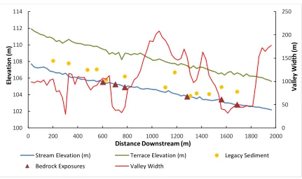
Longitudinal profiles of the channel and high terrace are essentially linear through the study reach regardless of substantial changes in valley width (Fig.2.8). The high terrace is constantly ~4 m above the channel. Thicknesses of legacy sediment exposed in the terrace scarps are relatively constant and vary from 2.7 to 3.6 m except for three relatively thin exposures at 1200 and near 1600 m where the exposures are near valley walls. Thickness at sites near valley walls can be thin due to the channel having shifted over a higher point in the pre-settlement floodplain (Fig.2.7). Additional variability in legacy sediment thickness can be attributed to a number of different factors, including valley width and proximity to ephemeral channels and gullies (Fig.2.9). Field
bedrock outcrops define a pattern that appears to be related to reaches where the valley is narrow and are absent in wide floodplains (Fig.2.8). This pattern suggests scour in valley narrows and pockets of deposition in wide valley sections, in conformance with
Magilligan’s (1985) model. Although depths to bedrock between exposures are
unknown, the outcrops constrain the minimum elevation of the pre-settlement longitudinal profile and indicate that it was no deeper than present.
Figure 2.7 – Longitudinal profile of Chicken Creek study area. Depths of the legacy sediment and pre-settlement soil contact below the high terrace maintain a relatively constant thickness except at 1200 m where the sample exposure site is against a valley wall 0 50 100 150 200 250 100 102 104 106 108 110 112 114
0 200 400 600 800 1000 1200 1400 1600 1800 2000
Va lle y W id th (m ) El ev at io n (m )
Distance Downstream (m)
Stream Elevation (m) Terrace Elevation (m) Legacy Sediment
Figure 2.8 - Legacy Sediment Thickness, proximity to sediment sources, and floodplain width at each sample site
A statistical regression analysis was conducted to examine potential factors governing legacy sediment thicknesses observed in the terrace scarps. Thicknesses were correlated with floodplain widths and proximity to tributary sediment sources (Fig. 2.9), and those two variables alone explained 18% of the variance in thickness. Three
sampling locations within this set were within 5 m from the valley wall and had relatively thin deposits. A third explanatory factor was added to the regression as a dummy
Magilligan’s floodplain sedimentation model. The floodplain sedimentation model
expected that sediment thickness would increase in areas where the valley was either narrowing or widening; therefore, changing over distance as opposed to absolute. The resulting multiple regression resulted in an adjusted R2 of 0.78 with residuals between predicted and observed thickness <0.49 m (Fig.2.11).
Figure 2.11 – Longitudinal profile of study area showing model predicted legacy sediment thickness in relation to observed measurements
2.4.2 SEDIMENTOLOGY OF LEGACY SEDIMENT
To provide a sedimentological description of the deposits, sediment textures and bulk densities were measured for 40 samples at three sites and the physical
sedimentology was described for the historical deposits and underlying sediment.
Sediment texture analysis generally shows that pre- and post-colonial regimes at the three sites have similar mean grain sizes (Fig.2.12). The samples were variable in texture but tended to have high percentages of sand (> 63 μm). Four of the legacy sediment samples
at site W1 (Fig.12B) had >30% clay and <40% sand, whereas the other four legacy 0 50 100 150 200 250 100 102 104 106 108 110 112 114
0 500 1000 1500 2000
V al ley W id th (m) El ev at io n (m)
Distance Downstream (m)
Model-Predicted Legacy Sediment
sediment samples at that site had <25% clay and >55% sand. This difference in legacy sediment texture at a single site represents the strong stratification of the deposit with a series of fining upward sequences that each begin with a sand layer and grade up to silts and clays. Overall, pooled sediment textures cannot be used to distinguish between the two sediment regimes, but the legacy sediment on Chicken Creek is much more stratified than pre-settlement sediment (Fig.2.13) and this resulted in a greater range of mean grain sizes between samples. The samples at site W2 are fairly representative of the visual appearance of many exposed sections, with very sandy stratified legacy sediment overlying a massive unstratified layer of sandy loam and sandy clay loam that has much more sand and silt than the historical sediment. Channel cross-section morphology has been linked to the textures of bank materials. In particular, Schumm (1977) indicated that width/depth was inversely related to the percentage of silt and clay in the banks. Although this, together with the lack of change in mean grain size, could lead to the conclusion that the adjusted channel morphology will ultimately return to a
Figure 2.12 – Soil Textural Analysis – A) Site U1 (samples taken at 20 cm intervals) B) Site W1 (samples taken at 50 cm intervals C) Site W2 (samples taken at 20 cm intervals D) All samples from all three sites
A
B
Figure 2.13 - Textural Analysis of Sites UC1, and W2
UC1
Bulk densities of five samples of legacy sediment (BDL) ranged from 1.235 g/cm3
to 1.368 g/cm3 and averaged 1.304 g/cm3, whereas five samples of pre-settlement alluvium (BDP) ranged from 1.403 g/cm3 to 1.657 g/cm3 and averaged 1.512 g/cm3.
Figure 2.14 - Examples of sedimentary structures with thin strata in legacy sediment. (A) Section with a transition zone ~0.5 m thick. (B) close-up of transition zone (between dashed lines). Pre-settlement sediment is below lower dashed line transit transition ends at upper dashed line with stratified tan silts and sands. (C) Second section with ~3 m legacy sediment. (D) close-up showing flame structures (above arrows labeled “F”).
BDP without the sample of the Bt horizon was 1.476 g/cm3, which is representative of
most of the pre-settlement sediment. Samples collected above the pre-settlement alluvial contact showed a consistently lower density than for samples from below the contact (Fig.2.15). The difference in means was tested for statistical significance using a two-tailed, equal variance t-test. Assumptions for the test were met and a Shapiro-Wilk normalcy test was completed to assure normalcy in the data set. The null hypothesis (H0:
BDL = BDP) was tested at the p<0.01 level. Using these parameters, the test generated a
result of p = 0.004, therefore, the null hypothesis was rejected. A Wilcoxon rank sum test was also performed, generating very similar results. As might be expected for younger sediment that has not been deeply buried, the legacy sediment tends to have a lower density than the older, underlying pre-settlement alluvium. In addition to the
implications of these differences in density regarding the evolution or identification of legacy sediment, bulk density is required to convert sediment volumes to mass, and few measurements have been reported in previous studies.
Figure 2.15 - Bulk Density of Legacy and Pre-Settlement Sediments
0 0.5 1 1.5 2
UC1 C W1 W2 M4
2.4.3 POST-AGGRADATION ADJUSTMENTS
Following the model of an aggradation-degradation episode and based on numerous bedrock exposures in the channel bed, these reaches of Chicken Creek have reached their maximum incision and are widening in response to this vertical constraint. Widening can be observed qualitatively in the channel, as numerous trees have fallen into and across the channel. These tree-falls destabilize the bank causing localized sloughing and recruitment of sediment into the active channel system. Additionally, the channel has created a narrow floodplain within the terraced incision, with point-bars, cut-banks, and occasional mid-channel bars. These fluvial features show that the channel is
widening into the channel walls.
channel change may have occurred (Fig. 2.17) Additional evidence of the channel having previously been further North than its current location can be seen in LiDAR shaded relief models as a series of small parallel ridges, which also suggests the
possibility of a multi-threaded channel at the location the time of maximum aggradation. (Fig.2.18).
Figure 2.17 – 1927 bridge construction plans of SC State Highway 215 over Chicken Creek. “Make Channel Change” highlighted.
2.4.4 DISCUSSION
An initial objective of this study was to compare the thicknesses of pre-colonial sediment to the thickness of legacy sediment. The nature of pre-settlement channels in the southeastern Piedmont has long been an open question. Were the channels scoured to bedrock with low riparian wetlands or high forested banks? Were the channels
themselves wetlands or beaver ponds? The bank exposures in Chicken Creek allowed a rapid assessment of these conditions. Preliminary measurements of pre-colonial
thicknesses above bedrock were insufficient for a complete analysis and there is a bias toward thin observations at valley narrows because thick layers prevented measurement to bedrock by the method used. Nevertheless, the overall signal from these
measurements is that the pre-settlement soil ranged from 1.1 m to 2.3 m (mean= 1.5 m) above bedrock, which is 1.25 m less than the mean LS thicknesses. From this it can be concluded that pre-settlement alluvium was substantially thinner than legacy sediment in valley narrows.
The pre-colonial stratigraphy did not provide much clear evidence of forested wetlands. Sediment near the low-flow water level was usually gleyed, but a limited amount of wood was found in the banks, except for a few tree stumps near the present low-water level. The stumps were generally a meter below the pre-colonial soil
suggesting a low woodland that was subsequently buried by pre-colonial sediment with enough time for the buried pre-settlement Ab soil to form. One small stump in the channel bed showed evidence of beaver gnawing (Fig.2.19). The silty sediment
pre-colonial environment of the Chicken Creek bottoms as wetlands, emergent forest, or bedrock required oversimplifications of the contrasting sedimentation environments that were observable. Apparently, the pre-colonial stream banks varied substantially in the downstream direction between thin marshy alluvium to well-drained banks with dark Ab horizons that indicate non-saturated pedogenic processes.
Figure 2.19 - A stump ~1 m below the legacy sediment/pre-colonial alluvium contact that was apparently gnawed by a beaver (Castor canadensis)
2.5 CONCLUSIONS
than pre-colonial sediment. This may help to distinguish between sedimentation regimes quantitatively and it certainly makes a difference to conversions of sediment volumes to mass.
Chicken Creek underwent a substantial transformation as a result of tremendous increases in sediment in the late 19th and early 20th centuries. After a period of rapid
aggradation, the channel began to incise back toward its original bed level. In some cases, this degradation occurred offset from the original channel location, and these lateral position changes can be seen in both terrace scarp exposures of the former
floodplain stratigraphy and in a comparison of 1938 and 2008 delineated channels. After relatively rapid vertical channel incision, qualitative evidence suggests that incision has slowed or ceased, and where bedrock is exposed in the channel bed in some locations incision has ceased. In some areas localized widening is clearly occurring and facilitating the creation of a new lower floodplain surface.
CHAPTER
3
The study area in the preceding manuscript provided a rare opportunity to
examine legacy sediment deposits and the pre-settlement floodplain surfaces below over nearly 2 km of stream. Not only has the channel in that area incised deeply to expose the sedimentary record, but forest service purchase of the land and a lack of modification or public access has allowed the channel and floodplain system to recover relatively naturally without further human changes. In essence, that site represents a controlled outdoor experiment where approximately 80 years of recovery from extreme
anthropogenic sedimentation can be observed.
This research is important in helping to document the drastic impacts that
European settlers imposed on the landscape during colonization of the Americas. While this study only represents the impacts of humans on one watershed, many of these impacts have been documented across the southeast and beyond. Undoubtedly many more areas exemplifying rapid geomorphic change remain unstudied and may in the future be important in better understanding the human impact on the landscape.
Continued research should further monitor floodplain and channel morphogenesis within these watersheds and monitor the long-term responses of the system to
REFERENCES
Alexander D.J. (1997). Channel morphological adjustment to soil erosion and sedimentation at the Chicken-Strong Creek confluence, Fairfield County, South Carolina. Unpublished master’s thesis. University of South Carolina, Columbia, South Carolina.
Beach, T., Dunning, N., Luzzadder-Beach, S., Cook, D.E., Lohse, J., 2006. Impacts of the ancient Maya on soils and soil erosion in the central Maya Lowlands. Catena 65, 166-178.
Blake, G. R., & Hartge, K. H. (1986). Bulk density p. 363-375. Methods of Soil Analysis: Part, 1.
Cluer, B.m Thorne, C. 2014. A stream evolution model integrating habitat and ecosystem benefits. River Res. Applic. 30, 135-154.
Costa, J.E. 1975. Effects of agriculture on erosion and sedimentation in the Piedmont Province, Maryland. Geological Society of America Bulletin 86: 1281-1286. Donovan, M., Miller, A., Baker, M., Gellis, A. 2015. Sediment contributions from
floodplains and legacy sediments to Piedmont streams of Baltimore County,
Maryland. Geomorphology 235, 88-105. doi.org/10.1016/j.geomorph.2015.01.025 Dotterweich, M. (2005). High resolution chronology of a 1300 year old gully system in
Northern Bavaria, Germany. Modelling longterm human-induced landscape evolution. The Holocene 15, pp. 994–1005.
Dotterweich, M., Ivester, A. H., Hanson, P. R., Larsen, D., & Dye, D. H. (2014). Natural and human-induced prehistoric and historical soil erosion and landscape development in Southwestern Tennessee, USA. Anthropocene8, 6–24.
Eargle, D. H. (1940). Relations of soils and surface in the South Carolina Piedmont. Science (Washington)91, 337-338.
Ederington, William. The news and herald. (Winnsboro, S.C.), 17 May
Fryirs, K., Brierley, G.J. 1999. Slope–channel decoupling in Wolumla catchment, New South Wales, Australia: the changing nature of sediment sources following European settlement. Catena 35, 41-63.
Gilbert, G. K. (1917). Hydraulic-mining debris in the Sierra Nevada (No. 105). US Government Printing Office.
Glymph, L. M. (1954). Studies of sediment yields from watersheds. International Association of Hydrological Sciences Publication, 36, 261-268.
Gee, G. W., & Bauder, J. W. (1986). Particle-size analysis. Methods of soil analysis: Part 1—Physical and mineralogical methods, (methodsofsoilan1), 383-411.
Happ, S. C. (1945). Sedimentation in South Carolina Piedmont valleys. American Journal of Science243(3), 113–126.
Happ, S. C., Rittenhouse, G., & Dobson, G. C. (1940). Some principles of accelerated stream and valley sedimentation (No. 695). US Department of Agriculture.
Ireland, H. A., Sharpe, C. F. S., & Eargle, D. (1939). Principles of gully erosion in the Piedmont of South Carolina (Vol. 631). US department of agriculture.
Jackson, C.R., Martin, J.K., Leigh, D.S., West, L.T. 2005. Journal of Soil and Water
Conservation60(6):298-310
Jacobson, R.B., Coleman, D.J. 1986, Stratigraphy and recent evolution of Maryland Piedmont flood plains American Journal of Science 286, 617-637.
James, L. A. (1991). Incision and morphologic evolution of an alluvial channel recovering from hydraulic mining sediment. Geological Society of America Bulletin103(6), 723-736.
James, L. A. (2006). Bed waves at the basin scale: implications for river management and restoration. Earth Surface Processes and Landforms31(13), 1692-1706.
James, L. A. (2011). Contrasting geomorphic impacts of pre-and post-Columbian land-use changes in Anglo America. Physical Geography32(5), 399-422.
James, L. A. (2013). Legacy sediment: Definitions and processes of episodically produced anthropogenic sediment. Anthropocene2, 16–26.
James, L.A. (2018). Conceptual models of large-scale legacy sedimentation - A Review.
Geomorphology. IN REVIEW.
Knox, J. C. (1977). Human impacts on Wisconsin stream channels. Annals of the Association of American Geographers67(3), 323-342.
Lecce, S.A., 1997. Spatial patterns of historical overbank sedimentation and floodplain evolution, Blue River, Wisconsin. Geomorphology 18, 265–277.
Macklin, M. G. and Lewin, J. (2008). Alluvial responses to the changing Earth system. Earth Surface Processes and Landforms 33, 1374–1395.
Magilligan, F. J. (1985). Historical floodplain sedimentation in the Galena River Basin, Wisconsin and Illinois. Annals of the Association of American Geographers 75(4), 583–594.
Meade, R. H. (1982). Sources, sinks, and storage of river sediment in the Atlantic drainage of the United States. The Journal of Geology90(3), 235-252.
Merritts, D., Walter, R., Rahnis, M., Hartranft, J., Cox, S., Gellis, A., Potter, N., Hilgartner, W., Langland, M., Manion, L., & Lippincott, C. (2011). Anthropocene streams and base-level controls from historic dams in the unglaciated mid-Atlantic region, USA. Philosophical Transactions of the Royal Society of London A: Mathematical, Physical and Engineering Sciences369(1938), 976-1009.
Nicholson, S. A., & Monk, C. D. (1974). Plant species diversity in old‐field succession on the Georgia Piedmont. Ecology55(5), 1075-1085.
Phillips, J. D. (1991). Fluvial sediment budgets in the North Carolina Piedmont.
Geomorphology 4(3), 231-241.
Schumm, S.A. 1977. The Fluvial System. N.Y.: Wiley Interscience; 338 pp. Schumm, S.A., Harvey, M.D., Watson, C.C. 1984. Incised channels: Morphology,
dynamics, and control. Water Resources Publications: Littleton, Colorado. Simon A, Hupp CR. 1986. Geomorphic and vegetative recovery processes along
modified Tennessee streams: an interdisciplinary approach to disturbed fluvial systems. Forest Hydrology and Watershed Management IAHS-AISH Publ. 167: 251– 262.
Shands, W.E. 1991. The lands nobody wanted: The legacy of the eastern national forests. Milford, PA: The Pinchot Inst. 30pp
Thompson, C.J., Croke, J., Fryirs, K., Grove, J.R. 2016. A channel evolution model for subtropical macrochannel systems. Catena 139: 199–213.
Trimble, S. W. (1974). Man-induced soil erosion on the southern Piedmont. Soil Conserv. Soc. Am., Ankeny, Iowa, 1700-1970.
Trimble, S. W. (1999). Decreased Rates of Alluvial Sediment Storage in the Coon Creek Basin, Wisconsin, 1975-93. Science285(5431), 1244–1246.
U.S. Bureau of the Census. Censuses of Agriculture. (1900). Washington, D.C.
Van Dyke, C., 2013. Channels in the making–an appraisal of channel evolution models. Geogr. Compass 7, 759–777.
Vanwalleghem, T., Bork, H.R., Poesen, J., Dotterweich, M., Schmidtchen, G., Deckers, J., Scheers, S., & Martens, M. (2006). Prehistoric and Roman gullying in the
European loess belt: a case study from central Belgium. The Holocene 16(3), pp. 393–401.
Walling, D. E. (1983). The sediment delivery problem. Journal of hydrology65(1-3), 209-237.
Walter, R., Merritts, D., & Rahnis, M. (2007). Estimating volume, nutrient content, and rates of stream bank erosion of legacy sediment in the Piedmont and Valley and Ridge physiographic provinces, southeastern and central PA. A Report to the Pennsylvania Department of Environmental Protection, 1-38.