HESPERIA 74 (2005)
Pages 585?611
A
ROMAN
CIRCUS
IN
CORINTH
ABSTRACT
During the 1967-1968 excavations of the Gymnasium area in Corinth, a long and narrow structure (the "Apsidal Building") was discovered. It is argued
here that the structure
represents the eastern meta and a portion of the spina of a circus, where chariot races were held. The circus appears to have been
planned as an integral component of the Caesarian design of the city, con
structed during the
Augustan period, renovated in the late 1st century a.D.,
and refurbished as late as the 6th century. Furthermore, the circus was often the site of the equestrian contests of the Corinthian Caesarea festival and at times of the Panhellenic Isthmian Games.
When Colonia Laus lulia Corinthiensis was founded in 44 b.c. by Julius Caesar, the new Roman colony was built on the site of the former Greek polis that had been destroyed by the consul Lucius Mummius in 146 B.c.1 During the interim period of 102 years, the Greek city was deprived of its civic and political identity and was largely deserted until the arrival of the earliest Roman colonists, a combination of freedmen and veterans.2 Although certain architectural elements of the Greek city were retained in the new foundation, the Roman architects and engineers brought with them a plan for the colonial city and proceeded over time to build new
1.1 thank John H. Humphrey, David R. Jordan, Guy D. R. Sanders, Kathleen Warner Slane, Charles K. Williams II, and James R. Wiseman for
assistance and
helpful discussions concerning the subject of this article. In particular, I would like to thank Slane for the pottery identification and description, and Williams for assistance with the
stratigraphie analysis. I am also
grateful to Wiseman for supply ing the photographs for Figs. 1,2,4, and 6. The drawings were
produced
by the Corinth Computer Project of
the
University of Pennsylvania Muse um of Archaeology and Anthropology. I thank all of the students who have
helped me both in Corinth and in Philadelphia, and in particular Timothy
Demorest, David Pacifico, and Nicho las L.
Stapp for their assistance in preparing the final drawings. Finally,
I thank the anonymous Hesperia reviewers for their comments and sug gestions on an earlier version of this
article.
References to the Corinth exca vation notebooks are abbreviated as
"Corinth NB"
throughout.
2. For the destruction of Corinth, see Paus. 2.1.2; Strabo 8.6.23;
Livy Per. 52. For the damage to the city,
see Wiseman 1979, pp. 491-496. For discussion of the
planning of the colony, see Romano 1993. For the colonists, see Strabo 8.6.23 (freedmen); Plut. Caes. 57 (veterans). See also the
recent study of the
early colony at
Corinth by Walbank (1997). For ac
tivity during the interim period, see
Williams 1978, pp. 21-22; Romano
1994, pp. 62-64.
? The American School of Classical Studies at Athens
American School of Classical Studies at Athens is collaborating with JSTOR to digitize, preserve, and extend access to
Hesperia
planned colony of 44 b.c., was probably constructed during the Augustan period.4 Later, under Vespasian, in the early 70s A.D., a second Roman
colony was founded at Corinth, Colonia lulia Flavia Augusta Corinthiensis, with subsequent planning and building activity.5
Another structure characteristic of a Roman city was the circus, the place where chariot races were held and where spectators watched the con
tests.6 Most typically, four-horse chariots, quadrigae, and two-horse chariots, bigae, would compete on a closed racecourse, although other equestrian contests and sometimes athletic, gladiatorial, and dramatic events could be staged in a circus as well.7 It is suggested here that Corinth had a circus and that it was planned from the earliest days of the colony, constructed as an integral component of the Augustan phase of the city, and then used throughout much of antiquity.81 also propose that the equestrian contests of the pentaeteric Corinthian Caesarea festival were held in this circus, and sometimes the Panhellenic Isthmian Games as well.
DESCRIPTION AND EARLY IDENTIFICATION
During the 1967-1968 excavations of the Gymnasium area in Corinth by the University of Texas, under the direction of James R. Wiseman, a
long and narrow structure was discovered ca. 45 m to the south of a structure ten tatively identified as the Gymnasium.9 The structure, aligned in a roughly east-west direction and called at the time the "Apsidal Building," was excavated for a distance of about 19 m with an interior width of ca. 3.5 m; the west end of the structure was not found, presumably lying beyond the area excavated (Figs. 1-3). The maximum width of the excavated structure is 4.49 m and the east-west length of the curved eastern portion is 4.84 m.
3. From the archaeological record one must assume that there was a par tial and selective physical destruction of the
buildings and structures of the Greek city. See Wiseman 1979, pp. 491-496.
4. Welch 1999, pp. 133-140. Welch
suggests that the date of the structure is based on its construction
techniques, which are most similar to those of other
amphitheaters built during the late 1st
century b.c., Sutrium in Etruria and Carmo in Baetica. Furthermore, she points out that, for both social and po
litical reasons, an amphitheater would have been a
necessity in a Roman col
ony founded by Julius Caesar. The lo
cation of the amphitheater at Corinth in the northeast corner of the colony is similar to the locations of amphi theaters in other Roman colonies,
just inside or outside the city limits.
5. The Flavian
colony is known from numismatic, epigraphical, and
(recently) archaeological evidence. See Corinth VI, p. 26, no. 93; Corinth VIII.3, p. 42, no. 82; Romano 2000;
2003, pp. 291-299. The second Roman colony is likely to have introduced new colonists into the
city.
6. The Lex Coloniae Genetivae, the colonial charter of Urso, a foundation of Julius Caesar in 44 b.c., indicates that the aediles were to organize games in the circus or gladiatorial contests in the forum. Each aedile was to
spend not less than 2,000 sesterces from his own money, to be
supplemented by 1,000 sesterces of public money. See Crawford 1996, vol. 1, pp. 423-424. It
is
possible that the same law was a part of the colonial charter of the Caesarian foundation at Corinth.
7. Humphrey 1986, pp. 71-72;
Beacham 1999, pp. 1-44.
8. It is very likely that Greek Cor
inth had a hippodrome although its
location has not been discovered. It must remain a
possibility that the site of the Roman circus could at an earlier date have been the site of the Greek
facility although Humphrey (1986,
p. 12) reminds us that "there is no Roman example of a Classical Greek hippodrome having been converted
into a canonical?i.e. monumental? Roman circus."
9. Wiseman 1969, pp. 64-72, pi. 20:b, c. For the excavations in the Gymnasium area, see also Wiseman
1967a, 1967b, 1972.1 thank Professor
Wiseman for discussing with me ele ments of this structure and for permis
sion to cite
A ROMAN CIRCUS IN CORINTH
587
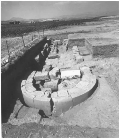
A
Figure 1. View of the "Apsidal Building" from the east, 1968.
Corinth Excavations; photo courtesy J. R. Wiseman
A hard-packed surface identified as that of a courtyard was found to the
north, east, and south of the structure.
The curved eastern end is constructed of eight well-finished, curved marble slabs that are backed by a series of large reused poros blocks of
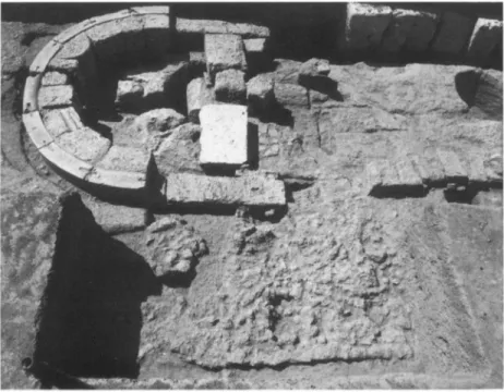
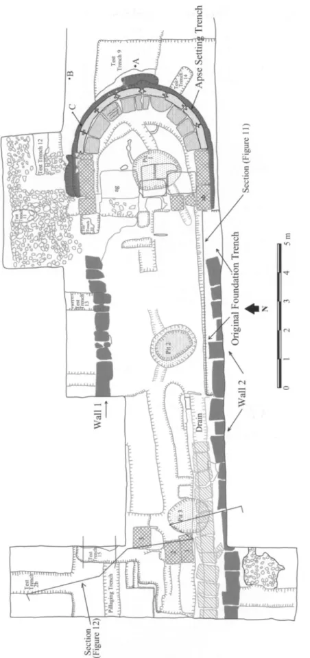
various shapes, including a column fragment. The curved marble slabs on the exterior were clamped together. One surface of every marble block is a half-round; all but one of these half-round surfaces have been embedded in the ground although in one case the half-round is the present top surface. Approximately 2 m west of the east end of the structure, the curved end of the wall is continued by rectangular blocks that run in a straight line approximately east-west. A cross-wall of additional reused blocks joins the ends of the curved eastern end of the structure.10 After an interval of 1-2 m, poros blocks, two courses high on the south, continue the east-west walls of the structure toward the west.
Three large pits cut into the bedrock were associated by the excavator with the original use of the structure. The pits, which are aligned roughly east-west, are spaced equally (ca. 6.0 m center to center) and are of similar dimensions.11 Shallow channels lead toward the pits from different direc
tions. To the south of the pits, a drain, approximately 0.50 m wide and 8 m long, covered with marble slabs, was excavated, beginning 11.5m west of the east end of the structure and extending west into the western scarp (Fig. 3). The drain is associated with a later use of the structure.
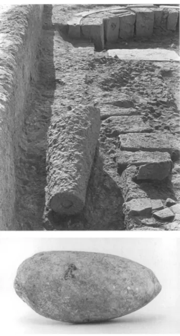
A number of worked marble pieces, including a large cone (Figs. 4,5), were found during excavation of the structure. The marble cone, found
10. One of the blocks, "ag" in Fig. 3, appears to have had an earlier use as a starting-line block from the dromos of a
gymnasium or stadium.
11. Wiseman (1969, p. 69) gives the
following dimensions: for pit 1, Diam. 1.65 m, D. 0.88 m; pit 2: Diam. 1.65 m, D. 0.79 m; pit 3: Diam. 1.45 m, D. 0.80 m. There is no indication of
j*,? *M^
Figure 2. View of the "Apsidal Building" from the north, 1968.
Corinth Excavations; photo courtesy J. R. Wiseman
immediately to the north of the walls, is characterized by having its apex cut horizontally; the top horizontal surface has a central circular cutting similar to an empolion cutting, 0.09 m in diameter and 0.018 m deep. The bottom of the marble cone is broken off and thus the original size and
form are not known.12
Several marble sculptural fragments were found in a 6th-century A.D. dump deposit above the Apsidal Building: a large marble egg-shaped ob
ject (S-2879; Fig. 6), a colossal marble hand (S-2877), and a third of the head of a young boy (S-2873) as well as most of his right arm (S-2876); a life-size terracotta comic mask (MF-12977) was also found.13 The left leg from a statue of an athlete (S-2923), with an attached palm tree support, was discovered just outside of the dump.14
Three lead tablets were excavated immediately outside of the Apsidal Building: MF-12994, MF-68-271, and MF-68-272 (Fig. 3:A-C).15 A heavy foundation wall, wall 16, was found approximately 18 m north of,
and roughly parallel to, the Apsidal Building (Figs. 7-9). This wall, 1.2 m wide, was excavated for a total length of approximately 16 m.16 At 6 and
12. A-767: max.
p.L. 1.38 m, Diam. (top) 0.28 m, max. p.Circum. 1.42 m.
Williams (1987, p. 386) describes the
shaft of the marble cone as "pick dressed" and notes the presence of two
"shallow boss-like protrusions" that are visible on one side of the shaft, 0.78 m below the horizontal top of the cone.
13. S-2879:
p.L. 0.384 m, max. Diam. 0.19 m. For photographs of
these objects, see Wiseman 1969, pis. 21:c, 22:a-c, 24:c. The excavator found four additional
fragments of ter
racotta masks nearby: MF-12949 and MF-12972, from a
3rd-century a.d. deposit in a bronze-casting pit; MF
12967, from a
lst-2nd-century deposit from test trench 8, west of a bronze foundry; and MF-12968, from a Late Roman
deposit from the east end of the Gymnasium south stoa. See Wiseman
1969, pp. 103-104, pis. 22:j-l, 32:c. 14. Wiseman 1969, p. 72, pi. 21:c.
15. MF-12994 (Fig. 3:A) and MF 68-271 (Fig. 3:B) were found in layers
of
hard-packed road metal to the east
and northeast of the eastern end of the structure (see below, nn. 23, 44).
MF-68-272 (Fig. 3:C) was found in
the foundation trench for the marble slabs at the northeast side of the curved east end of the structure (Corinth
NB 379, pp. 144-149; NB 418, pp. 149-152,169-172). MF-12994 is
illustrated in pi. 21:a in Wiseman 1969. See also Jordan 1985, pp. 166-167.
Section
(Figure 12)
Apse Settirii Trench
Figure 3. Actual-state plan of the "Apsidal Building." After Corinth NB 425, p. 115; Wiseman 1969, p. 68, fig. 2; Corinth Computer Project
Figure 4 (above, left). Marble trun
cated cone as discovered during excavation, 1968. Corinth Excavations; photo courtesy J. R. Wiseman
Figure 5 (above, right). Marble trun
cated cone. Corinth Excavations
Figure 6 (left). Marble egg. Corinth
Excavations; photo courtesy J. R. Wiseman
10.5 m north of wall 16, where the West Waterworks structure begins, are robbing trenches (labeled as two pillaged trenches) for two walls that run parallel to wall 16 (Figs. 8, 9).17 The space between these walls was filled with dumped material.
Twenty-five meters to the east of the eastern (excavated) end of wall 16, and on the same axis, Wiseman found evidence for a similar wall, 1.50-1.70 m wide; this stretch was excavated to a length of 8.15 m (Fig. 7). An additional lead tablet was found in this vicinity, approximately 23 m to the northeast of the east end of the Apsidal Building.18 The wall continued under a farm road to the west, and its robbing trench was discovered to
the east for another 7 m as cuttings in bedrock. A parallel wall was found approximately 7 m north of this wall. The northern wall, about a meter wide originally, is partially preserved and robbed. Wiseman suggested that
these two parallel foundations may have been for a stoa, with a total width
17. Corinth NB 453, p. 189. 18. This lead tablet (MF-68-273)
largely disintegrated during excavation.
See Corinth NB 350, pp. 30-32; Wise
man 1969,
Late Roman Wall
West Waterworks
Gymnasium Stoas
Domed Building
Wall 16 sv?Gymnasium South 1 Trench
spina meta
N
0 50
Figure 7. Geo-rectified actual-state drawing of excavated features and trenches. Corinth Computer Project
Pillaging Trench 2 ?..^>
West Waterworks
Floor
Figure 8. Area to the north and south of wall 16. After Corinth NB 453, p. 189; Corinth Computer Project
(including the walls) of 8.75 m, and that the building faced south onto an open hard-packed courtyard, which was explored for 19 m to the south of
the foundations (Fig. 7).19
The only excavation undertaken to the west of the long and narrow structure (ca. 60 m to the west) was the early trench I, excavated by R. B. Richardson in 1896, in which a portion of a Late Roman wall made up of spolia was discovered (Fig. 7). In addition, to the south, Richardson dug a narrow north-south trench approximately 50 m long in which he found very little other than a series of blocks covering an area ca. 5 m wide at
the north end.20
Although Wiseman did not positively identify the structure in the original excavation report, Charles K. Williams subsequently made the sug gestion that the Apsidal Building could be a rural or outdoor shrine to Diana Nemorensis, possibly set up by the Roman freedmen when settling the
Caesarian
colony.21 Williams envisioned an open-air t?menos surrounded
by a simple low wall and suggested that the original shrine to Diana, from the early days of the Caesarian colony, had been located somewhere near the Fountain of the Lamps (Fig. 16, below) and that it was rebuilt with its
19. Wheel ruts were found at the bottom of test trench 1 of trench "Gym South 1," to the south of these founda
tions; Wiseman 1967b, pp. 420-421. The elevation of these ruts is 54.150 m. For
comparison, in test trench 9, at
the east end of the Apsidal Building (Corinth NB 425, p. 71), the elevation
of the hard floor surface
dating to the 4th century is 54.363-54.358 m.
20. Richardson 1897, pp. 457-458.
Wiseman (1967b, pi. 92) reproduces
the plan by W. B. Dinsmoor of the 1896 trenches.
A ROMAN CIRCUS IN CORINTH
593
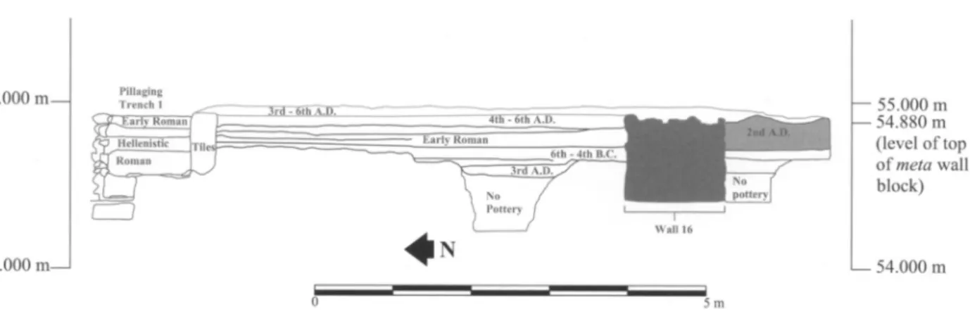
55.000 m?\
54.000 m
- 55.000 m -
54.880 m
(level of top
of meta wall
block)
L_ 54.000 m
Figure 9. Section drawing showing the stratigraphy to the north and south of wall 16. Section line indi
cated on
Figure 8. After Corinth NB 425, p. 193; Corinth Computer Project
original component parts in the present location. He identified the trun cated marble cone as a sacred log, or
lignum, dedicated to Diana, of a type known from frescoes from Herculaneum and the House of Livia on the Roman Palatine. Fresh considerations of the excavated evidence, however,
incorporating the newly understood principles and manifestations of the planning and design of the Caesarian colony at Corinth, indicate instead
that the architectural features of the so-called Apsidal Building represent part of a circus facility.
IDENTIFICATION OF THE APSIDAL BUILDING
AS A CIRCUS
I owe the original idea of the identification of the Apsidal Building as a circus meta and spina to Williams.22 The eastern end of the excavated struc ture is of an appropriate general size and shape for the low wall of a meta, or turning post, of a Roman circus. This feature at Corinth is surrounded on three sides?north, east, and south?by a series of layers of hard-packed road metal.23 The two lines of parallel blocks extending to the west (Fig. 3: walls 1,2) could reasonably define the spina of a circus. Furthermore, many
of the finds associated with the so-called Apsidal Building can be related to the functions of a meta or spina or to the use of the overall facility as a circus. For comparisons of design, the western turning post (meta secunda) of a circus at Lepcis Magna has been excavated and published and serves as a close parallel (Fig. 10).24
The large truncated marble cone described earlier, found above the foundations and near the north wall of the structure, should be interpreted as a
part of the turning post itself; the empolion cutting at the top of the cone would have received a finishing element.25 At least one additional
22. Charles K. Williams II (pers.
comm.). Williams suggested this possibility to me in 1978 although, as
noted above, he later (1987) published
the structure as the shrine to Diana Nemorensis.
23. The
daily excavation record
(Corinth NB 425, pp. 71-87) describes
a series of
hard-packed floors, up to 0.50 m
deep, several of which date to the 4th century.
24. The
example at Lepcis Magna measures ca. 6.9 m (N-S) and
5.8 m (E-W). At Lepcis Magna
the meta is detached from the spina as appears to also be the case in Corinth.
Kerb
5 m
Figure 10. Lepcis Magna, west meta. After Humphrey 1986, p. 43, fig. 23; Corinth Computer Project
member of the cone should be restored below the preserved piece, and the stone egg may have rested on top (see below).26 The three lead tablets can also be related to the functioning of the circus; a number of lead tablets
have been excavated in circus contexts and proven to be curse tablets.27
Curse tablets positioned at the starting gates and turning posts of circuses would, by means of "aggressive magic," have served to initiate some form
of misfortune on the charioteer and chariot team.28
The equally spaced pits within the meta and spina, one of which (pit 2) was excavated with a portion of an amphora still in situ, and the associ
ated channels could be interpreted as a series of connected water basins, hydraulic facilities sometimes found within the spina of circuses.29 An attractive alternative interpretation is that the pits and inlaid amphoras
26. Humphrey (1986, pp. 46-47,
fig. 27) restores the cones at Lepcis Magna as 4.06 m tall (4.75 m, includ
ing the crowning egg). 27. See Heintz 1998. Wiseman (1969, p. 70, pi. 21 :a, b) describes and illustrates one of the lead tablets, MF-12994, currently under study by
David Jordan. Wiseman writes that "the script is Greek; a few of the letters are
printed' but most of the writing is cursive." This curse tablet is associated
with pottery lot 4881, dating to the
late 4th-5th century. It was found at an elevation of 54.521 m. MF-68-271
(elev. 54.554 m) is associated with pot
tery lot 5555, dating to the 6th century,
and MF-68-272 (elev. 54.518 m) with pottery lot 5568, dating generally to the
Roman period.
28. At Antioch, for example, five of the 13 curse tablets found in the
city were located in drains along the central
barrier and turning posts of the circus; Heintz 2000.1 am
grateful to David Jordan for the information that several
curse tablets from Carthage and Had rumentum curse race horses named
Korinthos (which is spelled Corentus
in the Hadrumentine
example), sug gesting that the horses may have come from Corinth, or at least that Corinth
was a
good source of horses. Although this coincidence does not
necessarily presuppose the existence of a circus or chariot racing at Corinth, it is sugges tive. For
examples of horses named Korinthos, see Audollent 1904, pp. 311-312, no. 235, line 27; 1906, p. 386.
29. Cf., e.g., the western meta at Lepcis Magna (Fig. 10). In reference to the barrier of the Circus Maximus,
Humphrey (1986, p. 294) observes:
"in the
A ROMAN CIRCUS IN CORINTH
595
were receptacles for trees or bushes.30 Such features, including amphoras used as planting pots, are known from Greek and Roman gardens.31 The north-south cross-wall at the western end of the meta was built, during
the later use of the structure, with a series of reused blocks, including a column fragment, partially covering and filling pit 1.
Immediately to the west of the meta are two other series of blocks, east-west foundations (walls 1 and 2), that continue for a maximum of 12 m (Fig. 3). These blocks have presumably been reset into the original foundation trenches of the walls from the spina. Originally the blocks are likely to have been stacked two to three courses high (see below, Fig. 14), similar to the situation at Lepcis Magna.32
The parallel foundation walls excavated to the north and northeast of the spina and meta may well be the foundations for a spectator gallery. It is likely that wall 16 was the foundation for a podium wall. It is customary that circuses have spectator facilities built along the sides of the racecourse and, although the evidence currently indicates their presence only to the north of the circus at Corinth, it would be expected that the gallery also continued around the south and west sides. The 5 m wide series of blocks found at the northern end of the southern portion of trench I (Fig. 7) may have been part of the northern spectator facilities of the circus.
Several objects discovered in the 6th-century dump fill above the east west foundations of the spina could have had a connection with the circus.33 The large stone egg could be interpreted as one of the ova commonly used
as counters for the laps of the chariot races; eggs were also used to decorate the top surface of the metae?A It is curious that a terracotta comic mask (MF 12977) was found in the dump fill. Theatrical performances were often an important aspect of circus activities, and pantomimes were known to have been included in circus programs from the 2nd century until the 6th cen
tury. It is conceivable, therefore, that this mask was used in such perfor mances in the circus in Corinth.35
CHRONOLOGY OF THE CIRCUS
The structure identified here as a circus had a long and complicated history and, in addition, was largely pillaged after its period of use. At least four phases can be recognized: construction in the mid- to late Augustan period;
renovation in the late 1st century A.D.; reworking in the 6th century; and abandonment later in the 6th century.
The date of the original construction of the circus would appear to be mid- to late Augustan based on several pieces of evidence from the area
of walls 1 and 2 and from the pits found within the spina and meta.
30.1 am
grateful to one of the anon ymous Hesperia reviewers for suggest
ing this idea to me.
31. See Gleason 1994, p. 16. Such planting pots, known as ollaeperforatae to the Romans, have been discovered at
Pompeii and Jericho; see Messineo 1984 for
examples. At the circus of
Lepcis Magna, Humphrey (1986, p. 38)
mentions that plants or trees could have been included on the barrier.
32. Humphrey 1986, p. 39, fig. 18.
33. It is not of course certain that the objects associated with the dump fill come from the circus.
34. See, e.g., Humphrey 1986, pp. 260-262, for discussion of the liter ary and archaeological evidence for the
eggs from the Circus Maximus.
35. MF-12977: Wiseman 1969,
pp. 71,104, fig. 3, pi. 22:a. For com paranda for the mask, see Agora VI, pp. 20-23, 59-62, pis. 11-15. For the role of theater in the circus, see Cam eron 1976,
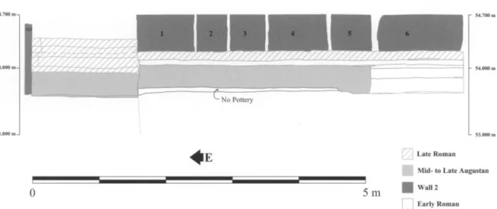
- No Pottery
4e
5 m
Late Roman Mid- to Late Augustan Wall 2
Early Roman
Figure 11. Section drawing north
of wall 2; section line indicated on
Figure 3. After Corinth NB 425, p. 78; Corinth Computer Project
Wall
2 (spina)
The original foundation trench of the southern east-west wall of the spina was located beneath wall 2, which was built in the 6th century. The blocks
of wall 2 sit on top of earlier layers of sediments that are Late Roman, Early Roman, and mid- to late Augustan in date (Fig. 11). Both east-west walls are
associated with the stone drain covered with marble slabs, which was prob ably built during the 6th-century refurbishing of the structure (Figs. 3,12). When the blocks of wall 2 were installed, the earlier foundation trench was not dug to its original depth so that the original stratigraphy remains. The earliest level excavated at the bottom of the trench of this wall is described as hard red earth dating to the early 1st century A.D.36
Wall
1 (spina)
A trench dug immediately to the north of wall 1, which was also built in the 6th century, revealed material from the early foundation trench, 1.15 m wide, dating to the Early Roman period.37
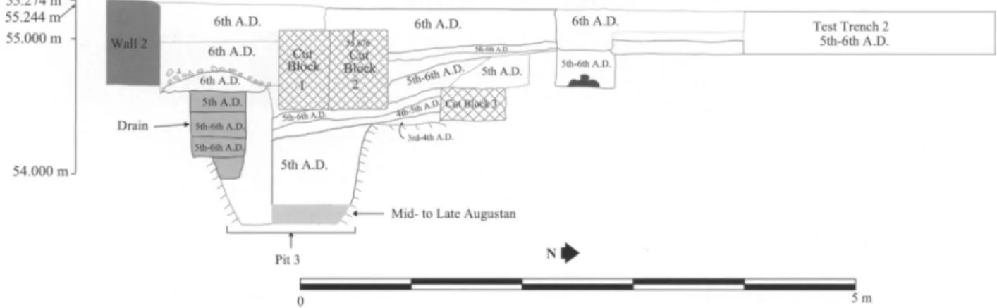
Pits (spina, meta)
The lowest stratigraphie level found at the bottom of pit 3 dates to the mid- to late Augustan period (Figs. 3,12).38 A stratigraphie level from the bottom of pit 2, although not precisely datable, can be dated generally to
36. Pottery lot 5530. Corinth NB 418, p. 95; NB 433 (elev. 53.908
53.558 m). The soil is described as red
dish brown. Approximately half of the
pottery is pre-Roman, mostly Hellenis tic. The other half is
Early Roman, and includes two unidentified red-slipped plate fragments of the late 1st century b.c., two casserole fragments (one floor and one rim), one cooking-ware frag
ment, and two
plain-ware bases.
37. Pottery lot 5575. Corinth NB 425, p. 80; NB 433 (elev. 54.644 53.636 m). The soil is described as light
brown and hard. The pottery includes Greek black
glaze, coarse wares, unfired Corinthian, a micaceous water jug frag ment, and an Early Roman lekane rim fragment. This trench was excavated as
test trench 13.
38. Pottery lot 5561. Corinth NB 418, pp. 131,136,189; NB 425, p. 43; NB 433 (elev. 54.634-53.373). The soil
is described as
sandy red. The pottery includes a handful of Hellenistic cook ing-pot sherds, an unidentified Roman amphora fragment, a Roman cooking pot rim, two fragments of thin-walled mid-late Augustan cups, and a Roman
A ROMAN CIRCUS IN CORINTH
55.274 m 55.244 n/\ 55.000 m
54.000 m J
6th A.D.
597
Test Trench 2 5th-6th A.D.
5m
Figure 12. Section drawing of pit 3
and
neighboring areas; section line indicated on
Figure 3. After Corinth NB 418, p. 189; Corinth Computer Project
the Roman period.39 Pit 1 was partially filled with a large column fragment but did not have datable levels.
Wall 16
The heavy foundation wall 16, ca. 18 m north of the spina (Fig. 7), must, on the basis of pottery found to the south of the wall, have been in place by the 2nd century A.D.40 To the north of wall 16 and extending for a distance of half a meter are several stratigraphie levels that together suggest a dumped fill, probably Roman, but not precisely datable (Figs. 8, 9).41 The strati graphic level that covers wall 16 probably dates to the early 6th century.42 39. Pottery lot 5533. Corinth NB
418, pp. 104,107, 111; NB 433 (elev. 54.168-53.810 m). The soil is described
as hard gray-brown to red-brown. The pottery includes a red-slipped plate
like that found in pottery lot 5530 (see
n. 36, above), one micaceous sherd that is not from a water
jar, and three frag ments of an
amphora. The amphora has been tentatively identified as either
a North Italian Dressel 6 or Spanish Dressel 7-11 amphora. It had probably
been used for
collecting water within pit 2, possibly for a tree or bush, as its neck and foot had been cut off. North Italian Dressel 6 amphoras date to the 1st century a.d. and the Spanish Dressel 7-11 type from the Flavian to
the early Antonine
period, until about a.d. 150. It would therefore be safe to
say that this amphora was set in place in
pit 2 in the 1st or 2nd century. Since the pits were
probably dug when the structure was first constructed, the amphora was presumably a replace ment for an earlier one.
40. Pottery lot 5902. Corinth NB 425, pp. 130,140,165-166; NB 433
(elev. 54.921-54.781 m).The soil is described as dark reddish brown. The
pottery includes two Italian Sigillata fragments (one of which is a foot of a Haltern 8 vessel), a battered
fragment of Eastern Sigillata B, a possible gray ware
fragment, a local red-slipped frag ment, a fragment from a lst-century
a.D.
white-slipped pitcher, two Italian thin-walled wares, a thin-walled (prob ably) local cup fragment, a local small round-mouthed pitcher, and a lekane fragment. Two black micaceous water jars can be dated to the late 1st century, and a gritty brown wheel-ridged sherd, possibly from an amphora, dates to the
late 1st or beginning of the 2nd cen tury. Two joining fragments with red slip derive from the late 1st, 2nd, or possibly even 3rd century.
41. Pottery lot 5899. Corinth NB
425, pp. 135-136,139-140,142,
148,178-179; NB 433 (elev. 54.914
54.596 m). The soil is described as red dish brown, with and without stones. Almost all of the pottery is Classical
and Hellenistic, including a fragment of a Corinthian B transport
amphora, a
fragment of a Corinthian A transport amphora toe, and several pre-Roman cooking-pot fragments. Possibly Ro man are a
probable bulbous unguen
tarium
fragment, an Eastern Sigillata A fragment, and a possible burned Sigil
lata
fragment. A piece of poros stucco, some
waterproof cement, and a piece of bronze were also found.
42. Pottery lot 5898. Corinth NB 425, pp. 125,128,132,137,158,160,
163,176; NB 453, pp. 22-23; NB 433
(elev. 55.166-54.850 m).The soil is described as
light brown to red-brown. This level includes some Classical pot
tery, a fragment of an Early Roman red-ware plate, an
Early Roman pitcher handle, an Early Roman pitcher foot
(cooking fabric), a fragment of a grooved basin rim, and two fragments of an
Early Roman water pipe. The Late Roman material includes a Late Roman C form 3B (mid- or second half of the 5th century), three fragments of
African Red Slip (3rd or 4th century), a Hayes 104C rim (525-600; see Hayes
1972, pp. 160-166), a cooking-pot handle, a folded-rim bowl fragment, an
imported Late Roman Aegean mica ceous
cooking-pot fragment (5th-early 6th
It is clear from the foundation trench cut into the hard-packed floors to the north, east, and south of the curved marble slabs of the meta that the slabs, mostly laid on bedrock, had been resituated late in antiquity. The foundation trench continues to the outside of some of the poros blocks north and south of the curved end, indicating that the marble slabs and
the poros blocks at the eastern end had been replaced or reset at one time. The resetting of the curved marble slabs at the east end of the meta can be dated to the 6th century A.D., allowing us to date the latest use of the entire structure to this time.43 From another part of the same reutilized foundation trench, at the east end of the meta, comes additional dating evi dence to corroborate the 6th-century date.44 A late-4th-century coin found on the racecourse floor, in hard-packed road metal within a meter of the east end of the meta, indicates a use at that time, or following in the early 5th cen tury.45 Another 4th-century coin was found on the road metal ca. 20 m
to the east.46
Important for this discussion is the fact that the curved exterior marble blocks of the meta were reset late in the history of the structure. The earlier meta had undergone renovation and repair, including refurbishing of the eastern exterior of the curved east end, probably as a result of wear and the rising elevation of the road levels. Based on the evidence for dating the road surfaces near the meta, the facility seems to have remained in use into the 6th century, although continuous use cannot be proven. The excavator has suggested that the structure went out of use during the 6th century, after which time a deep garbage dump covered much of the structure. This dumped fill would have been deposited later in the 6th century, after the
resetting of the exterior marble slabs of the meta.47
RECONSTRUCTION
OF THE CIRCUS
It may be useful to summarize the phases of development thus far docu mented for the circus in Roman Corinth. The original construction took
place during the mid- to late Augustan period. The form of the circus would
43. Pottery lot 5557. Corinth NB 418, pp. 166-167; NB 433 (elev. 54.577-54.513 m).The soil is described as light brown and rocky. The finds
include a
fragment of a Late Roman micaceous water
jar, an Early Roman double-rolled handle, several fragments of a Late Roman amphora (probably Palestinian), and a fragment of a Late Roman water pipe.
44. Pottery lot 5555. Corinth NB 418, pp. 149,152,166; NB 433 (elev.
54.687-54.566 m).The soil is described as
light red-brown to hard brown with
pebbles. The pottery includes two handles from Late Roman micaceous water
jars, two fragments of Late Roman amphoras of type 2, two frag ments of a Palestinian amphora, a toe
from a
Gaza-type amphora, a cook ing-pot rim (probably 6th century), a fragment of 3rd-century African Red Slip ware, and a probable 6th-century African Red Slip ware
fragment. Also contained in this pottery lot is a lead curse tablet, MF-68-271.
45. Corinth NB 418, p. 174: a test trench
through the hard road metal,
elev. 54.566-54.484 m. The coin
(68-1428) is datable toTheodosius I,
Valentinian II, or Arcadius, a.d. 383
388; I thank Orestes Zervos for this
information.
46. Corinth NB 350, p. 87: a hard packed area, elev. 54.889 m. Coin 66 563, of Constantius II or Constans, a.d. 341-346, was found in this area.
A ROMAN CIRCUS IN CORINTH
599
meta prima
spma
meta secunda
Augustan Period
meta prima jzzzzzr
spma
podium meta secunda
^3
ca. A.D.
100
N
200 m
Figure 13. Restoration drawings of
the Corinth circus in the Augustan
period and ca. A.D. 100. Corinth Com puter Project
have included the spina, two metae, starting gates (carceres), an arena, and perhaps little else (Fig. 13).48 The spina and the metae were constructed by digging foundation trenches into the bedrock, into which the foundation blocks were set; the trench for these foundations was 1.15 m wide and
1.2 m deep. Several courses of stone above the foundation level would then have been required to create a low wall for both features (Fig. 14). The north-south cross-wall, ca. 4 m west of the curved end of the meta,
suggests that the meta was separated from the spina by a space. The three large pits were probably dug directly into bedrock at the same time, as part of the initial construction of the metae and spina, and may have been
intended for the planting of trees or bushes. The total width of the arena in the Augustan phase may have been ca. 55 m (ca. 25.5 m to the north of the spina and 29.5 m to the south) as there is no evidence for any formal spectator accommodation at this time and there appears to have been space for a racecourse of this width (Fig. 13). The carceres are likely to have been built at the east end of the facility (see below).
In the 2nd century a.d. a spectator gallery, with a maximum width of ca. 8 m,49 was constructed on the north side of the circus, probably ex tending along the south and west sides as well (Figs. 7, 8, 13). These spectator accommodations would have diminished the total width of the racecourse proper, at least in this area, from ca. 55 to 39 m.50 The race course width to the north of the spina would have been restricted to ca. 18 m. The spectator capacity of the facility can be estimated at approximately
12,000.51
48. It is by no means certain that the spina of the circus was continuous from the east end to the west end.
49. The width of the spectator gal lery is based on the dimensions of the excavated foundations on the north side of the circus.
50. In
Fig. 8, the sarcophagus to the
south of wall 16 is Greek (pottery lot
5923). Covering the sarcophagus is a deposit, pottery lot 5909, dating to the 1st century a.d. See Corinth NB 453, pp. 45-50.
51. This estimate is based on the formula of 0.5 m2 per spectator
(Romano 1993b, p. 22). Hansen (1996,
pp. 25-29) discusses minimum space requirements for individuals standing and sitting in areas of assembly and
0
Figure 14. Reconstruction draw ing of the eastern meta and spina at Corinth, 6th century a.d. Corinth Computer Project
Over time the racecourse surface was raised as layers of road metal were created on the track. In the 6th century, when the meta and spina were renovated, the original trenches for the foundation walls were reutilized but the refitted blocks were not set fully into the trenches (Figs. 3,11). By
this time the foundation walls (including wall 16) for the spectator facility to the north had gone out of use and been covered (Fig. 9).
PLAN AND LOCATION OF THE CIRCUS
It is not known whether carceres were located at the east or west end of the circus. If they were located at the eastern end of the facility, more space would have been available for the total length of the arena. Given topographical constraints, the arena could have been as long as 388 m if the carceres were located at its eastern end, but only ca. 330 m if they were located at its western end, since, in circus design, the space required from the carceres to the meta secunda is greater than the space required from the closed end of the circus to the meta prima (Fig. 13).52
Although from the 2nd century on the available arena width between the eastern meta and the spectator facility to the north was only ca. 18 m, thus implying the narrower space associated with a meta prima rather than
a meta secunda, other evidence suggests that this was not the case. The lo
cation of the foundations for the spectator facilities that are only roughly parallel to the arena and some 35 m east of the eastern meta indicates that
the arena continued some distance to the east and did not turn to follow the semicircular end of the circus. The curved end of the arena should thus be found at the western end of the circus. The orientation of the spectator facilities to the north of the circus suggests that the northern spectator wall flared slightly to the north by approximately 1? 30', providing more space for the starting chariots from the carceres in the east to the meta secundaP The projected location of the carceres is near that of the major cardines that
approach the center of the city from the north. For instance, there would have been a major roadway (likely to be cardo IV west) leading north from
the Theater to the area of the Asklepieion and the Gymnasium. There is ample space in the plan of the city for this possibility and the arrangement would thus be similar to examples elsewhere in the Roman world.54
52. Humphrey (1986, p. 334) states
that "the preferred orientation for a cir
cus [in North Africa] seems to be that
the starting gates should be at the west, the semicircular end at the east."
53. This arrangement is similar to
the hypothetical plan illustrated by Humphrey (1986, p. 22, fig. 5:c).
54. See, e.g., Ribera 1998 for the recently discovered circus at Valentia (HispaniaTarraconensis). There, in the reconstruction of the circus, the carceres are
only ca. 150 m to the east of the forum and immediately to the south of the decumanus maximus, very close to the center of town. Other examples of Roman circuses,
especially later ones, e.g., in Thessaloniki, were constructed close to a
major thoroughfare and next to a
palace; they are likely to have crossed earlier
A ROMAN CIRCUS IN CORINTH 601
The identification of the eastern meta and spina of a Roman circus in Corinth provides an
important part of the plan of the Roman colony of 44 b.c.55 As a result of research carried out by the Corinth Computer Project
since 1988, it has been possible to reconstruct a "drawing board plan" of the Caesarian colony, covering 240.6 hectares and divided into four centuries,
or quadrants, each of 240 iugera (Figs. 15,16).56The urban area is arranged lengthwise with respect to the north-south axis of the colony and probably had as its dominant unit an area measuring 1x2 actus (1 actus = 120 feet or 35.4 m). The primary north-south orientation of the grid of the Roman city is ca. 3? west of north (N3? 3' 46" W), based on the orientation of the east curb of the Lechaion Road as the cardo maximus of the colony. The principal surveyed cardines of the city are oriented generally 2-3? west of north; the decumani are generally 2-3? south of west. The average orientation of the east-west foundations of the meta of the circus are 2? 47' 51" south of west, which is within 16' from the principal east-west orientation of the Roman colony. Typically the metae and spina of a circus are oriented obliquely to the axis of the arena in order to provide sufficient space to the right of the meta secunda for the starting chariots. This appears to be the case at Corinth, where there is, as a result of the oblique planning, slightly more
room to the north of the spina, in front of the attested spectator facilities, than there is to the south.
The location of the meta as a part of the spina of the circus falls close to the middle of a 2-actus north-south dividing line within the organiza tion of the city (Figs. 15,16). It is known that a major east-west roadway, decumanus III north, lay 3 actus to the south of the meta, and I have sug gested elsewhere that the northern east-west limes of the city was located ca. 1 actus to the north of the meta}1 Decumanus IV north would then have been located immediately to the south of the circus and decumanus V north immediately to the north (Fig. 16). Within the 2-actus space projected as the maximum potential width of the circus, there is slightly more room to the south of the axis of the meta than there is to the north, 38.2 m and 32.6 m, respectively, although it is clear that the entire width of the 2-actus
space was not utilized. There can be little doubt that the orientation and location of the circus were planned with respect to the layout of the Ro man city since the total width of the circus would fit into the 2-actus block,
including room for spectator facilities on the retaining walls to the north, and presumably also the south.
Without the spectator facilities included in the planning, the available space for the racecourse, as noted above, would have been ca. 55 m (Fig. 13).
Furthermore, space remains in the urban plan for an east-west Roman
roadway to the north of the circus, decumanus V north (Fig. 16).58
55. See Romano 1993, pp. 13-21, figs. 3-5, 7.
56. The Corinth Computer Project
of the University of Pennsylvania Mu seum of
Archaeology and Anthropol
ogy was directed from 1988 to 1997
by the author. The project was carried out under the auspices of the American
School of Classical Studies at Athens, Corinth Excavations, C. K. Williams II, Director.
57. Romano 1993, p. 20. 58. This roadway was put out of use
by the construction of the West Waterworks and the Domed
CIRCUS