International Journal of Emerging Technology and Advanced Engineering
Website: www.ijetae.com (ISSN 2250-2459,ISO 9001:2008 Certified Journal, Volume 3, Issue 10, October 2013)
369
Review of Different Methods Used for Large-Scale Urban Road
Networks Traffic State Estimation
Prof. D. N. Rewadkar
1,
Tuhina Dixit
2Abstract— The information regarding to the real time
traffic is widely used for system like Intelligent Transportation Systems (ITS) for its applications such as vehicle navigation, incident detection, traffic signal control, traffic monitoring, etc. In addition to this, the system such as Advanced Traveler Information Systems (ATIS) as well as Advanced Traffic Management System (ATMS) also requires the current conditions of urban road traffic along with its short term evolution. Thus the main theme of this paper is about the estimation or collecting the information related to traffic state for large scale urban road networks. For estimating the traffic state of such networks, we need to have efficient and effective method in place so that overall performance will improve. There are many methods presented by different authors, however each of this method suffered from few limitations. By considering these limitations, still this is a promising area of research for researchers. As this is the first step of our research, in this paper we are presenting the different methods presented for estimating traffic state as well as advanced sensor techniques have been adopted to collect real-time traffic information.
Keywords--Traffic State Estimation, Intelligent
Transportation Systems, Traveler Information Systems, Advanced Traffic Management System, Large Scale Road, Vehicles, GPS.
I. INTRODUCTION
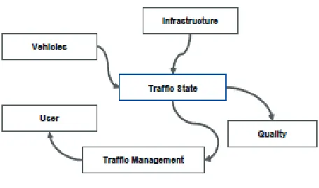
In the successful wide scale deployment of Advanced Traffic Management Systems (ATMS) and Advanced Traveler Information Systems (ATIS) relies significantly on the capability to perform accurate estimates of the current traffic status and reliable predictions of its short-term evolution (less than one hour in the future) on the entire road network. Figure 1 showing the infrastructure of management of traffic by estimating traffic state.
In this view the use of real-time Floating-Car Data (FCD), based on traces of GPS positions, is emerging as a reliable and cost-effective way to gather accurate traffic data for a wide-area road network and to improve short-term predictions of travel conditions. Unlike other traffic
data collection techniques (Automated Vehicle
[image:1.612.331.559.211.345.2]Identification systems, video cameras, inductive loops, radar based sensors, etc.), floating cars, using GPS receiver and GSM/GPRS transmitter, act as moving sensors traveling in a traffic stream and do not require instrumentation to be set up on the roadway.
Figure 1: Infrastructure of Traffic Management System.
Besides increasing the understanding of individual travel behavior, floating car technique can easily provide near real time traffic performance data on any part of large networks and offers a viable way to complement fixed-point traffic sensors, such as cameras and loop detectors, involving high installation and maintenance cost.
Fixed sensors are a proven technology; they are not deployed at wide scale mostly because of its high cost. The current state-of-the-practice traffic data collection in most parts of the world is to rely on a network of road-side sensors, e.g., inductive loop detectors (ILDs), to gather information about traffic flow at fixed points on the road network [2-4]. Moreover, with fixed sensors, it is only possible to measure the spot speed, which is one inherent deficiency in comprehensive reflection of speed over the entire road link. Additionally, this type of model is link and
detector location specific, which requires careful
International Journal of Emerging Technology and Advanced Engineering
Website: www.ijetae.com (ISSN 2250-2459,ISO 9001:2008 Certified Journal, Volume 3, Issue 10, October 2013)
370 Moreover, since PVs are chosen from a particular category of vehicles, e.g., taxis or buses, the traffic information could be biased and not representative of the whole population [10].
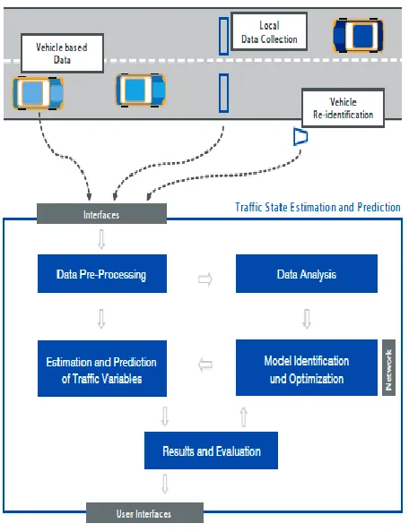
[image:2.612.53.281.272.569.2]In advance of the mobile communication technology, mobile phones are increasingly utilized for collecting traffic data. This approach avoids installation and maintenance costs, either in vehicles or along roads. In addition, using mobile phones as traffic probes overcomes the coverage limitation in road-side sensors and insufficient probes in dedicated PVs.
Figure 2: Example of traffic state estimation and prediction system.
Past decade, field trials have been conducted to show the feasibility of using mobile phones as traffic probes [10, 13-16]. Nevertheless, most of these trials tried to estimate traffic states on freeways and only few deployments attempted to monitor urban arterial roads. It has been suggested in [10] that future research efforts should be focused on obtaining traffic data for arterials where no data is currently available rather than obtaining data from freeways where fixed traffic sensors are al-ready deployed.
However, traffic estimation on arterials is more challenging than on freeways due to the following facts [7, 14, and 17]: 1) arterials have lower traffic volume; 2) arterials have more variability in speeds; and 3) arterials are controlled by traffic signals at intersections. For study purposed we have studied the VANET routing mobility models those are presented in [18].
This challenge of traffic estimation is overcome by many methods which are presented recently for the same. In this paper we are presenting the discussion over such methods along with their advantages and disadvantages for future road map of research. Below in section II we will present different methods for collect real-time traffic information, later in section III we will present the different methods for estimating the traffic state in urban road networks. Finally conclusion is derived based on review of all methods.
II. REVIEW OF REAL-TIME TRAFFIC INFORMATION
COLLECTION METHODS
On some large-scale field-testing results of a real-time freeway network traffic surveillance tool that has recently been developed to enable a number of real-time traffic surveillance tasks is described in [1]. That paper first introduces the related network traffic flow model and the approaches employed to traffic state estimation, traffic state prediction, and incident alarm. The field testing of the tool for these surveillance tasks in the A3 freeway of 100 km between Naples and Salerno in southern Italy is then reported in some detail.
International Journal of Emerging Technology and Advanced Engineering
Website: www.ijetae.com (ISSN 2250-2459,ISO 9001:2008 Certified Journal, Volume 3, Issue 10, October 2013)
371 These two speeds are taken as the inputs of the
proposed fusion platform. Finally, tests on the
accuracy, conflict resistance, robustness, and
operation speed by real-world traffic data illustrate that the proposed approach can well be used in urban traffic applications on a large scale.
In [3] author presented the results of a before-and-after probe-vehicle-based operational comparison of optimized time-of-day (i.e., before control) and SCATS (i.e., after control) traffic control system performance. The focus of this operational analysis is the typical operating performance during the weekday peak, weekday off-peak, and weekend travel periods. Travel time data were collected using Global-Positioning-System (GPS)-equipped test vehicles. The results showed that both systems provided good performance, whereas neither the before time-of-day or after SCATS is clearly dominant, except on
Cumberland Parkway, where SCATS control
consistently provides equivalent or superior
performance to that of the time-of-day control.
In the [4] they self-diagnosing intelligent highway surveillance system and design effective solutions for both daytime and nighttime traffic surveillance. For daytime surveillance, vehicles are detected via
background modeling. For nighttime videos,
headlights of vehicles need to be located and paired for vehicle detection. An algorithm based on likelihood computation is developed to pair the headlights of vehicles at night. Moreover, to balance between the robustness and abundance of acquired information, the proposed system adapts different
strategies under different traffic conditions.
Performing tracking would be preferred when traffic is smooth. However, under congestion conditions, it is better to obtain traffic parameters by estimation. They utilize a time-varying adaptive system state transition matrix in Kalman filter for better prediction in a traffic surveillance scene when performing tracking. Also propose a mechanism for estimating the traffic flow parameter via regression analysis.
In [5], authors discussed a new real-time urban monitoring system. The system uses the Localizing and Handling Network Event Systems (LocHNESs) platform developed by Telecom Italia for the real-time evaluation of urban dynamics based on the anonymous monitoring of mobile cellular networks.
In addition, data are supplemented based on the instantaneous positioning of buses and taxis to provide information about urban mobility in real time, ranging from traffic conditions to the movements of pedestrians throughout the city. This system was exhibited at the Tenth International Architecture Exhibition of the Venice Biennale. It marks the unprecedented monitoring of a large urban area, which covered most of the city of Rome, in real time using a variety of sensing systems and will hopefully open the way to a new paradigm of understanding and optimizing urban dynamics.
In [6] authors described a system for measuring the state of a road network in real time. That appears to be the first cost-effective, scalable system that provides real-time measurements of vehicle count and individual vehicle travel times in the links of a road network. The system requires deployment of wireless magnetic sensors at locations that demarcate each link. The deployment is flexible in the way links are defined. A link may span several intersections and not all lanes in a link may be sensed. Deployment can be incremental. The system is based on anonymous matching of vehicle magnetic signatures recorded by sensors at the ends of a link
III. REVIEW OF TRAFFIC STATE ESTIMATION METHODS
In [8], the three analyses methods included to assist in
the process of understanding the GPS/GIS
International Journal of Emerging Technology and Advanced Engineering
Website: www.ijetae.com (ISSN 2250-2459,ISO 9001:2008 Certified Journal, Volume 3, Issue 10, October 2013)
372 The analysis also shows a tradeoff between sampling
rates and segment speed reliability, and emphasizes the need for even shorter GPS sampling periods (1– 2 s) in order to minimize errors in the computation of segment speeds. The central tendency analysis compares harmonic mean speeds and median speeds and shows that median speeds are more robust estimators of central tendency than harmonic mean speeds.
In [9] some probe vehicles cannot provide accurate
positions but can provide location-specific
information on when and where they are located at the segment or cell level. These topological position (TP) data with segment- or cell-level accuracy cannot provide the distance component that is necessary for traffic speed estimation. However, considering the wide availability of TP data in the existing telecommunications network, there is still hope and benefits to make use of the data for traffic state estimation. An algorithm is proposed using low-resolution positioning data. They implement proposed
method is capable of fusing low-resolution
positioning data with other data sources, leading to more accurate and reliable speed estimation of relatively low bias. In addition, this method shows strong robustness and error tolerance and can reveal the magnitude of the estimation error, which is helpful for travel time prediction and traffic control.
In [10] author presented approach for real-time traffic state estimation on urban road with signalized
intersection is presented. The conventional
discretization of kinematic wave model for freeway based on demand and supply concept is modified in order to be capable of describing traffic state on urban road with signalized intersection and to better estimate of traffic speed. The novel filter, namely Unscented Kalman filter (UKF), is used as a correction algorithm to make the estimate to be consistent with observed traffic data. Numerical tests show superiority of the modified model over the conventional model on speed estimation and the improvement in flow estimation when combining the model with UKF.
In [11], the traffic supply is estimated by the ideal carrying capacity, and the traffic demand is evaluated by vehicle traffic intensity considering resident travel characteristics. In this way, the network carrying capacity and traffic intensity are compared by equities unit.
By introducing the intensity/capacity ratio, the matching degree between traffic demand and supply is determined, and the traffic state is identified based on average vehicle speed.
In [12], author presented the development of a
laboratory designed to explore GPS and other emerging traffic and traffic-related data for traffic monitoring and control. It also presents results to illustrate the scope of traffic information that can be provided by GPS-based data, using the city of Stockholm as a case study. The preliminary analysis shows that network coverage, especially during peak weekday hours, is adequate. Further investigation is needed to validate the data, and increase its value through fusion with complementary data from other sources.
In [13], a kernel-based density estimation method is utilized to extract the congestion spots in urban areas based on collected position samples with time-stamp from floating car data. A probabilistic framework is developed to model the traffic data with generalized Gaussian density and then to find optimized weights of kernels in an approximation function, centered at points-of-interest by minimizing the Cramervon
Mises distance between localized cumulative
distributions of mixture of Dirac distributions of position samples and Gaussian mixtures of points-of-interest in a pre-defined time window. The approximation density function by optimized kernels' weights can be used to estimate the mobile vehicles density in a specific time and space. Modeling the traffic data to extract the required parameters improves the performance significantly. The proposed method is applied to real measurements and can be implemented in real time in traffic management systems.
International Journal of Emerging Technology and Advanced Engineering
Website: www.ijetae.com (ISSN 2250-2459,ISO 9001:2008 Certified Journal, Volume 3, Issue 10, October 2013)
373
In [15], the author introduced fusion-based system composed of real-time traffic state surveillance. This system can realize the real-time traffic state estimation with over 10,000 bidirectional road sections, all the links of the Shanghai urban road network. The system consists of three modules: SCATS data processing (MS), GPS data processing (MG), and Fusion Module (FM). In MS, traffic information collected by SCATS is converted into a kind of link-based spatiotemporal mean-speeds. Similarly, the taxis 'information is also calculated for the spatiotemporal mean-speeds by means of a GIS-T map in MG. The spatiotemporal mean speed here is defined by the mean speed of all the vehicles running on a link during a period of time.
IV. CONCLUSION
In this paper we have discussed the different methods for traffic state estimation along with their advantages and disadvantages. This study will definitely helpful for further research over the same area. Traffic stage estimation has two important things to do: first is the real time data collection and second is based collected information estimation of traffic efficiently. We will further like to estimate the performance analysis of these methods with comparative analysis.
The estimation of traffic is very helpful for the systems like traffic management in big cities. As implementation point of view, GPS-equipped taxis can be viewed as pervasive sensors and the large-scale digital traces produced allow us to have a unique view of the underlying dynamics of a city’s road network.
REFERENCES
[1] Y. Wang, P. Coppola, A. Tzimitsi, A. Messmer, M. Papageorgiou, and A. Nuzzolo, “Real-time freeway network traffic surveillance: Large-scale field-testing results in southern Italy,” IEEE Trans. Intell. Transp. Syst., vol. 12, no. 2, pp. 548–562, Jun. 2011. [2] Q.-J. Kong, Z. Li, Y. Chen, and Y. Liu, “An approach to urban
traffic state estimation by fusing multisource information,” IEEE Trans. Intell. Transp. Syst., vol. 10, no. 3, pp. 499–511, Sep. 2009.
[3] M. P. Hunter, S. K. Wu, H. K. Kim, and W. Suh, “A
probe-vehicle-based evaluation of adaptive traffic signal control,” IEEE Trans. Intell. Transp. Syst., vol. 13, no. 2, pp. 704–713, Jun. 2012.
[4] H.-Y. Cheng and S.-H. Hsu, “Intelligent highway traffic surveillance
with self-diagnosis abilities,” IEEE Trans. Intell. Transp. Syst., vol. 12, no. 4, pp. 1462–1472, Dec. 2011.
[5] F. Calabrese, M. Colonna, P. Lovisolo, D. Parata, and C. Ratti, “Real-time urban monitoring using cell phones: A case study in Rome,” IEEE Trans. Intell. Transp. Syst., vol. 12, no. 1, pp. 141– 151, Mar. 2011.
[6] K. Kwong, R. Kavaler, R. Rajagopal, and P. Varaiya, “Real-time measurement of link vehicle count and travel time in a road network,” IEEE Trans. Intell. Transp. Syst., vol. 11, no. 4, pp. 814– 825, Dec. 2010.
[7] A. Tarko and N. Rouphail, “Travel time fusion in ADVANCE,” in
Proc. Pacific Rim TransTech Conf., Seattle, WA, 1993, pp. 36–42. [8] C.A. Quiroga and D. Bullock, “Travel time studies with global
positioning and geographic information systems: An integrated methodology,” Transp. Res. C: Emerging Technol., vol. 6, no. 1/2, pp. 101–127, Feb. 1998.
[9] Q. Ou, R. L. Bertini, J. W. C. (H.) van Lint, and S. P.
Hoogendoorn,“A theoretical framework for traffic speed estimation by fusing lowresolution probe vehicle data,” IEEE Trans. Intel. Transp. Syst., vol. 12, no. 3, pp. 747–756, Sep. 2011.
[10] R. Pueboobpaphan and T. Nakatsuji, “Real-time traffic state
estimation on urban road network: The application of unscented Kalman filter,” in Proc. 9th Int. Conf. Appl. Adv. Tech. Transp., Chicago, IL, 2006, pp. 542–547.
[11] S. Jia, H. Peng, and S. Liu, “Urban traffic state estimation considering resident travel characteristics and road network capacity,” J. Transp. Syst. Eng. Inf. Tech., vol. 11, no. 5, pp. 81–85, Oct. 2011.
[12] M. Rahmani, H. N. Koutsopoulos, and A. Ranganathan,
“Requirements and potential of GPS-based floating car data for traffic management: Stockholm case study,” in Proc. 13th Int. IEEE Annu. Conf. Intell. Transp. Syst., Madeira Island, Portugal, 2010, pp. 730–735.
[13] A. Tabibiazar and O. Basir, “Kernel-based modeling and
optimization for density estimation in transportation systems using floating car data,” in Proc. 14th Int. IEEE Annu. Conf. Intell. Transp. Syst., Washington, DC, 2011, pp. 576–581.
[14] W. Shi, Q.-J. Kong, and Y. Liu, “A GPS/GIS integrated system for
urban traffic flow analysis,” in Proc. IEEE Intell. Transp. Syst. Conf., Beijing, China, 2008, pp. 844–849.
[15] Q.-J. Kong, Y. Chen, and Y. Liu, “A fusion-based system for traffic
state estimation: A case study of Shanghai,” IEEE Intell. Transp. Syst. Mag., vol. 1, no. 1, pp. 37–42, Jun. 2009.
[16] R. Herring, A. Hofleitner, P. Abbeel, and A. Bayen, “Estimating arterial traffic conditions using sparse probe data,” in Proc. 13th Int. IEEE Annu. Conf. Intell. Transp. Syst., Madeira Island, Portugal, 2010, pp. 929–936.
[17] A. Hadachi, C. Lecomte, S. Mousset, and A. Bensrhair, “An
application of the sequential Monte Carlo to increase the accuracy of travel time estimation in urban areas,” in Proc. 14th Int. IEEE Annu. Conf. Intell. Transp. Syst., Washington, DC, 2011, pp. 157–162.
[18] Mr. Rahul Shilpakar, Jaishri Panchal, “Analysis of VANET Mobility