© 2017, IRJET | Impact Factor value: 5.181 | ISO 9001:2008 Certified Journal
| Page 2041
Optimization for a Collaborative Delivery System
Salah Elhadi Aboharba
1, Kutluk Bilge. Arikan
21
PhD Candidate, Department of Mechatronic Engineering, Atilim University, Ankara, Turkey
2
Assistant Professor, Department of Mechatronic Engineering, Atilim University, Ankara, Turkey
---***---Abstract -
In recent years Unmanned Aerial Vehicles (UAV) have been used progressively in numerous civilian and military applications. Furthermore, there have been countless studies concentrating on the UAVs for their utilization in delivery systems, aiming at improving quality of delivery and reducing manpower. However, there are still many complications which require to be investigated. One of these complications is the inadequacy of flight time due to power insufficiency of small battery used in such systems, which results in the UAV failure to serve all customers directly from the main warehouse. To overcome this issue, a collaborative system between UAV and UGV is proposed. This system will deal with the optimization problem otherwise known as Vehicle Routing Problem (VRP) and the issue is solved by using the nearest neighbor heuristic algorithm. Moreover, MATLAB software is employed to implement the algorithm and simulate the system. The result shows that this system is faster than the system using a regular delivery truck.Key Words
:
collaborative between UAV/UGV, deliverysystem, VRP, nearest neighbor heuristic.
1. INTRODUCTION
In recent years, the robotic technology has been increasing at a fast pace, which make robots more practical to do human- like works efficiently without any rest. A Multicopter is rotary craft type, of unmanned Aerial Vehicle (UAV). The chief feature of Multicopter is undoubtedly its ability to deliver cargo in a 3D space due to better maneuverability, simple mechanical structure and good relationship between total weight and payload capacity. Therefore, numerous studies conducted using the unmanned Aerial Vehicle (UAV) in the field of logistics. A study carried out by the National Aeronautical Centre (NAC) discloses that 42% of logistics’ carriers shall consider in their business plans the utilization of UAVs for the distribution of cargo in the future. Also, the study concludes that 36% of "Freight Forwarders Surveyed" reckon UAVs will be used for the delivery of cargo [1]. Another study carried out by Raffaelo D' Andrea, who is responsible for the flying machine arena. He detailed some calculations to reach at the feasible expenses of drone delivery and he states that the operating costs directly linked with the drone are on the order of 10 cents for a 10
Km range and a 2 Kg payload. Furthermore, compare this with 60 cents per item, which we used over a decade ago in our trade plan for the total cost of distribution of cargo, so it is economically viable to deliver small packages by drone [2]. There are many logistics’ companies that employ an aerial system for delivering cargo to customers, which will reduce manpower and also improve the quality of delivery. Amazon develops an aerial system for delivering packages to customers within 30 minutes of ordering. The order utilizes GPS and has to be small enough to fit in the cargo box and must be less than 5 pounds, also the delivery spot should be within a ten mile (16 Km) radius, at speeds of up to 50 mph (80.5 km/h) and the packages weighing up to 5 lb. (2.26 kg) [3]. In September 2014, DHL started using UAV for the delivery of important packages such as medication, between a harbor on mainland Germany and a small island called Juist, for a distance of 12 Km. The UAV can carry a payload of up to 1.2 Kg at a maximum speed of 65 km/h. The UAV can complete its mission in 15 to 30 minutes, depending on the weather conditions [4].
Consequently, it is a clear insight, that is in order to make the cargo delivering efficient, effective and faster, the UAV is an ideal candidate to solve this problem. This is due to a single point hover, high maneuverability, vertical takeoff, landing, and the ability to carry loads ranging from 50% to 100% of their body weight [7].
© 2017, IRJET | Impact Factor value: 5.181 | ISO 9001:2008 Certified Journal
| Page 2042
Finally, a comparison between these systems and theregular delivery truck will be discussed to demonstrate that this system is more efficient, effective and faster.
Table-1: comparison between truck and UAV.
Capacity Speed Weight Operation time
Truck High Low Heavy Long
UAV Low High Light Short
1.1 Related Literature
There is a large amount of studies working on the traveling salesman problem (TSP) and vehicle routing problem (VRP). Although not all these foundational problems are directly applicable to the problem at hand, only some studies are directly related to our problem. The vehicle routing problem (VRP) is the problem related to distribution of goods between depots and customers [8]. The traveling salesman problem (TSP) is a special case of the VRP. For more detail and an overview of the vehicle routing problem and TSP, types, formulations and solution procedures see books [8] [9], and studies [10] [11]. In the [12] the researchers at the university of Cincinnati and AMP electric vehicles have worked to develop a delivery truck-drone system work for parcel delivery. The system is a collaborative between the electric truck and drone. The truck driver can make the delivery on the main route while the drone serves other customers one by one and returning to the base (truck) after each delivery to pick up another parcel. In the [13] the AMP electric vehicle works for testing a new collaborative system between the electric vehicle and UAV to deliver parcels that are outside of the main delivery route of the truck. The UAV is loaded with parcels and takes off to make the delivery and in the same time the truck will continue on its journey. After the UAV completes the delivery it will fly back to the truck for next delivery and also for recharging its battery. In [14] and [15] the authors have developed a new mixed integer linear programming formulation for a collaborative system between a drone and a delivery truck called "Flying Sidekick Traveling Salesman Problem" (FSTSP) and "Traveling Salesman Problem with Drone" (TSP-D) respectively. In [14] two problems are studied, the first one where the depot is out of the UAV’s flight range. Therefore, the customers are served by delivery truck unless some of them are served by drone. In the other problem, the customers are served directly from the warehouse and only some of them are out of the UAV’s flight range, therefore, delivery truck will serve them as well. An efficient heuristic algorithm was utilized to compute the solution of two problems and to compare with the delivery truck only. The delivery time is reduced when used the collaborative system. [15] It is similar to the FSTSP and the only difference is that the authors assume that the drone and truck travel on the same road which allows to
develop a heuristic algorithm with approximation guarantees. The two previous studies are quite similar to our problem where they proposed a collaborative system between a truck and drone and used a heuristic algorithm to solve the problem, however, the formulation is different in the problem as the previous studies used mixed integer programming formulation. Mixed integer programming is needed when the problem involves both routing and missions resolving. Mission resolving is required to determine which vehicle, truck or drone, will serve which customers, and routing resolving is required as well to determine in which sequence the customers on each vehicle are visited. Since our problem is VRP and all customers will service by UAV only, integer linear programming is used to formulate it and the nearest neighbor heuristic will be used to solve it. The other difference that is obvious here, is that we use the UGV as a sub warehouse to solve the limited flight time problem of UAV, in addition, this will make the delivery system more automated.
1.2 Problem description
© 2017, IRJET | Impact Factor value: 5.181 | ISO 9001:2008 Certified Journal
| Page 2043
should be taken into account.
Fig-1: The UAV is delivered to all customers from the warehouse within the UAV's flight range, some customers
out of flight range.
In this scenario, the system may consist of one or more than one Multicopters and one UGV. The system considers a set of n customers each of them must be served accurately once. The UGV is loaded in distribution center by parcel which will be delivered to the customers and carries an UAVs. The customers will be represented by n nodes and node n+1 added for UGV. When the UAVs starts the service from node n+1 (UGV), there is more than one path. Each path starts and ends in the UGV node and serves n customers as shown in figure (2). The Multicopter has limited flight time and a maximum loading capacity. This problem is known as a vehicle route problem and solving this problem will reduce the delivery time and improve the efficiency of the system.
Fig-2: Optimized delivery system by using UAV and UGV to serve all customers.
The Multicopter should leave and return back to the same point (UGV) exactly once. Over the delivery cycle the Multicopter might do many flights, each consists of three locations or more. The Multicopter begins the flight at the base on the UGV (where it is loaded with, a parcel for a customer). A service time may be required before launching to replace or charge the battery and to load the parcel. The second location in the flight must be a customer that is served by the Multicopter. It may serve more than one customer and it depends on endurance time and payload. The final location of the flight is the base on the UGV. Therefore, the flight time of the UAV should be within the UAV's flight time limit. The objective function is to minimize the time required to serve all customers.
2. Model formulation
The vehicle routing problem (VRP) is becoming one of the most important topics in logistics and it deals with minimizing the total cost of logistic system. The formal definition is given as the graph theoretic models. To find the mathematical formulation, the following parameter notation is utilized by the integer linear programming.
2.1 Notation
G = (V, A): is a complete graph where V is a vertex set (nodes) and A is the arc set (paths between nodes). The vertices V = 1,..., n corresponding to the customers, the depot, which in this case the UGV is associated with . Let C= ( ) be a cost matrix (distance) associated with A. The matrix C is said to be symmetric when ,
, and asymmetric when ,
: is the decision variable. It is equal to 1 if the vehicle travel from node i to node j and is equal to 0 otherwise.
: is the travel cost spent to go from i to j with each arc . It is considered as the distance for travelling from node i to node j.
N : is the set of all nodes in the network, it is denoted as N = {1, ... ,n}.
M : is the maximum number of unmanned aerial vehicles that can be used.
T : is the endurance time, which is exactly the maximum route duration time for the vehicle. This time consists of the time of service and the traveling time from node i to node j (customer).
© 2017, IRJET | Impact Factor value: 5.181 | ISO 9001:2008 Certified Journal
| Page 2044
B : is the maximum energy capacity of the batteryThe objective function is to minimize the route length, which is the total traveling distance to serve all customers:
(1)
Subject to:
(2)
(3)
(4)
(5)
(6)
(7)
for all
Constraint (2) guarantees that each customer is reached from either the depot or from another customer. Constraint (3) guarantees that from each customer, we go to another customer or to the depot node. Constraints (2) and (3) ensures that each customer is served exactly once. Constraints (4) and (5) guarantee that exactly m vehicles depart from and return back to node n+1 which represents the UGV. Constraints (6) guarantees that the travelling time and service time at each customer is not encroaching the maximum route duration time T. Constraints (7) guarantees that the vehicle's travel distance cannot exceed the maximum travel distance L.
Due to the limited battery capacity of Multicopter, the energy consumption must be taken into account. So to travel between two points, it is necessary to find the minimum energy consumption paths. To reduce the energy consumption for the Multicopter, there are some characteristics that should be considered, such as that
payload, speed of the vehicle and the environment conditions. In this study, we only add the constraints of energy consumption to ensure the Multicopter will complete its mission and avoid entering into the crashed state.
(8)
(9)
The constraint (8) represents the level of charge of the battery, is the current energy available and it has to be smaller than the previous current energy , and (r) is the energy consumption per Km/mile when, the vehicle is travelling from a customer node to any other node.
The constraint (9) guarantees that there is enough remaining energy to return to the base. Both constraints guarantee that the available energy is always positive in any nodes. B is the maximum energy capacity of the battery.
3. NEAREST NEIGHBOR HEURISTIC ALGORITHM
Most of vehicle routing problems are not solved optimally in reality because the solution is growing exponentially with the number of customers. Suppose there are n customer to be served by one vehicle. Then the total number of feasible solutions is (n-1)! Which grows exponentially [16]. For n = 5 the feasible solutions are 24 while, for n = 8 the feasible solutions 5040. There are many methods to solve the VRP, exact, approximate and simulation. The exact method guarantees that the optimal solution is found, but it is suitable only for the small size problem. Normally, branch and bound algorithm used to provide exact solution. A heuristic method is a procedure that is possibly used to discover a very good feasible solution. However, not necessarily an optimal solution. The main advantage of the heuristic method is their speed and ability to handle large problems. Simulation method is still in an early stage of implementation. It can effectively handle the problem of the complex system. It is used when the problem size is grown up.
The nearest neighbor heuristic, is a simple approach for solving the VRP. It was one of the first algorithm used to determine a solution to the VRP. The algorithm starts at the node , and repeatedly visits the nearest nodes until all have been visited. It quickly yields a short tour, but usually not the optimal one [17]. The procedure of the nearest neighbor heuristic algorithm with many constraints is shown in a chart (1).
ij ij A j A i
X
C
min
N
j
X
X
ij N jN j i i
1,1
,
1
N
i
X
X
ij i N N i j j
, 11
,
1
m
X
N jN
j
1,1
m
X
i NN
i
, 11
T
X
t
C
ij i ij N j N i
)
(
1 1L
X
C
ij ijA j A i
A
j
i
,
)
(
1
,
0
ijX
)
1
(
)
.
(
0
y
j
y
i
r
c
ijX
ij
B
X
ij)
.
min(
, 1
ini
r
c
© 2017, IRJET | Impact Factor value: 5.181 | ISO 9001:2008 Certified Journal
| Page 2045
For our problem, first the nearest neighbor algorithm isutilized to solve a problem with n=5 and n=10, for symmetric cost matrix utilizes a truck. The distances between customers are shown in figure (3) for n=5. Consequently, MATLAB software is utilized to find the minimum cost for the Multicopter to serve all customers and return back to the base.
Fig-3: The distance between customers for n = 5 and symmetric matrix.
stop start
Select node n+1
Find the nearest unvisited node
and go there
Are there any unvisited nodes
left? Go back to started node No
Yes If t less than or equal T- tb
Yes
No No
Chack the battery capacity If yi greater than
min(r.Ci,n+1) Yes
Chart -1: Flowchart for nearest neighbor algorithm
4. SIMULATION AND RESULT
[image:5.595.45.268.215.349.2]The solution for n=5 is shown in table (2) and the shortest tour is shown in figure (4). The short distance traveled is 47 m for all tours, as a result, the truck starts from any node and it will be the same distance traveled.
Table-2: The path and distance for N =5 symmetric customers.
Tour No Paths Distance Traveled
1 1→2→3→4→5→1 47
2 2→1→5→4→3→2 47
3 3→4→5→1→2→3 47
4 4→3→2→1→5→4 47
5 5→1→2→3→4→5 47
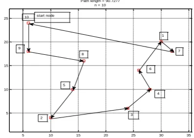
For n=10 the location coordinates of customers are shown in table (3) and the shortest path is shown in figure (5). The route is starting from node 10 and serves all customers and
returns back to the start node as:
10→9→8→5→2→3→4→6→1→7→10 whit minimum distance 90.72 Km.
0 5 10 15 20 25 30 35
-5 0 5 10 15 20 25
Path length = 47 N = 5
2
3 4
5
1
Fig-4: The shortest tour for symmetric problem and n = 5
5 10 15 20 25 30 35
5 10 15 20 25
Path length = 90.7277 n = 10
10
9
8
1
7
5
2
4
[image:5.595.326.525.311.475.2]3 6 start node
Fig -5: The shortest tour for problem with n = 10 used truck
[image:5.595.90.199.398.627.2] [image:5.595.335.534.544.685.2]© 2017, IRJET | Impact Factor value: 5.181 | ISO 9001:2008 Certified Journal
| Page 2046
to add constraints and solve the problem to compare it withthis solution.
To use the Multicopter for delivering cargo, we have to consider the system under some assumptions:
- The parcel is small, so the UAV can serve more than
one customer.
- The UAV can fly direct without any obstacles in its
way.
- The weather condition will not be considered.
From [3] and [4], the maximum distance the UAV can travel is about 30 Km in 30 minutes, so the energy consumption per Km from the full charge battery can be calculated as:
The energy consumption per Km is 3.333 % from the FSOC. Two cases are considered, first one, is that the UAV will serve ten customers. The Location coordinates of the customers are shown in table (3)
Table-3: Location coordinates of the customers Number of
customers x-coordinate /km y-coordinate /km
1 15 10
2 5 2
3 12 3
4 14 5
5 7 5
6 13 7
7 16 9
8 8 8
9 3 9
10 3 12
The solution is shown in figure (6) and table (4). Started from node 8 the UAV can serve all the customers with three tours and return to the same node. In each tour, it served three customers. At the end of each tour the UAV will land on UGV to change the battery and load on next parcel. Figure (7) shows the distance traveled and the state of charge SOC at every customer for each route.
Fig-6: Distance traveled and the state of charge SOC for n=10
Table-4: Tour No. and distance traveled Tour
No Path Visited nodes Traveled Distance
1 8→5→2→3→8 3 20.24
2 8→6→4→7→8 3 19.86
3 8→9→10→1→8 3 27.54
To compare between the Multicopter and truck, the time required to serve all customers is calculated. We assume the speed of the UAV is 80 Km/hour, and the maximum flight time is 30 minutes, so to travel one Km the time required is 0.75 min. The time required for service cycle starting from the base (UGV)
(9) Where is the distance traveled from customers i to j, and
is service time at customer i and its equal to one minute. , is the time rate to travel one Km.
© 2017, IRJET | Impact Factor value: 5.181 | ISO 9001:2008 Certified Journal
| Page 2047
Table -5: Compare the delivered time between UAV andtruck (three UAVs for three tours)
Customers Delivered time by
UAV min.
Delivere d time by
truck min.
Average delivered
time by UAV
Average delivere
d time by truck
1 31 93.8
14.53 59.84
2 11.15 46.6
3 21.75 67.8
4 12 76.29
5 5.74 35.78
6 8.64 83
7 18.7 98
8 0 26.29
9 8.64 11
10 13.14 0
From the result, we see that the average time for delivery by using Multicopter is less than by using truck if we use only one Multicopter to serve all customers in three routes. On the other hand, if we use three Multicopter for three routes the average time will be much lower than in the previous case. Therefore, the use of Multicopter in the delivery system is better and it makes the delivery process faster than using the truck.
Table -6: Compare the delivered time between the truck and UAV (one UAV for three tours)
Customers Delivered
time by UAV min.
Average delivered
time by UAV
Average delivered
time by truck
5 5.74
51.64 59.84
2 11.15
3 21.75
8 31.36
6 40.01
4 43.36
7 50.07
8 62.16
9 70.81
10 75.31
1 93.56
8 104.48
The second case, the Multicopter will serve five customers, the result is shown in figure (7) and table (7).
[image:7.595.312.557.394.457.2]Figu-7: Distance traveled and the state of charge SOC for n=5
Table -7: Tour No. and distance traveled
Tour No 1 2 3
Path 4→5→1→4 4→2→4 4→3→4
Visited nodes 2 1 1
Distance
Traveled 22.91 20.61 26.68
From the figure above, we see that the UAV starts from node 4 and it’s the best solution to service all customers with minimum distance. Due to long distance between some customers, it serves only one customer in two routes.
5. CONCLUSION
© 2017, IRJET | Impact Factor value: 5.181 | ISO 9001:2008 Certified Journal
| Page 2048
REFERENCES
[1] National Aeronautical Centre (NAC) "The Unmanned Future of Logistics", www.cornwalldevelopment -company .co.uk, 05 September 2014.
[2] Raffaello D' Andrea, "Guest Editorial Can Drones Deliver", IEEE, Transactions on Automation Science and Engineering, vol, 11,NO.3, July 2014.
[3] Amazon, “Amazon Prime Air,” Amazon, [Online].
Available: http://www.amazon.com.
[4] DHL,http://www.dhl.com/en/press/releases/releases_2014/g roup/dhl_parcelcopter_launches_initial_operations_for_rese arch_purposes.html.
[5]
Victor Olivares, Felisa Cordova, Juan M.
Sepulveda, Ivan Derpich, "Modeling
Internal
Logistics by Using Drones on the Stage of
Assembly of Products"
,ScienceDirect, Procedia
Computer Science, 55(2015) 1240-1249.
[6] Valentina Gatteschi, Fabrizio Lamberti, Gianluca, Alberto Lisanti, Giorgio Venezia, "New Frontiers of Delivery Services Using Drones: a Prototype System Exploiting a Quadcopter for Autonomous Drug Shipments", IEEE 2015 39th Annual International Computers, Software& Applications Conference.
[7] Aleksandra Faust, Ivana Palunko. Patricio Cruz, Rafael Fierro, "Automated aerial suspended cargo delivery through reinforcement learning", Accepted 23 November 2014, Available online at ScienceDirect.
[8] Paolo Toth and Daniele Vigo, "The Vehicle Routing Problem", Society for Industrial & Applied Mathematices, Philadelphia, SIAM, 2002.
[9] Bruce Golden, S. Raghavan and Edward Wasil, "The Vehicle Routing Problem: Latest Advances and New Challenges", Operation Research/Computer Science Intrfaces, springer, 2008.
[10] Tolga Bektas, "The multiple traveling salesman problem: an overview of formulations and solution procedures", Received 2 December 2003; accepted 11 October 2004, Available online at ScienceDirect
[11] Rajesh Matai, Surya Prakash Singh and Murari Lal Mittal, "Traveling Salesman Problem: An Overview of Applications, Formulations, and Solution Approaches", 2010, Available from:
http://www.intechopen.com/books/traveling-salesman-problem-theory-and-applications/traveling
salesmanproblem-an-overview-of-applications- formulations-and-solution-approaches.
[12] Marcus Wohlsen, "The next big thing you missed: AMAZON's delivery drones could work-the just need trucks", 2014, Available from:
http://www.wired.com/2014/06/the-next-big-thing-you-missed-delivery drones-launched-from-trucks-are-the-future-of-shipping.
[13] DHL Trend Research. “Unmanned Aerial Vehicles in
Logistics", A DHL perspective on implications and use cases for the logistics industry, 2014.
[14] Niels Agatz, Paul Bouman, Marie Schmidt, "Optimization Approaches for the Traveling Salesman Problem with Drone", August 1, 2015.
[15] Chase C. Murray, Amanda G. Chu, " The flying sidekick traveling salesman problem: Optimization of drone-assisted parcel delivery", Transportation Research Part C 54 (2015) 86–109, Accepted 4 March 2015, Available online at ScienceDirect.