Marg-Sudhar : Pothole Reporting System Using Android Smart
Phone
Riya Agrawal, Payal Patel, Yash Telang, Ankita Bhandarkar, Irfan Mushtaq, Dr. S. V. Sonekar Department of Computer Engineering, JD College of Engineering and Management, Nagpur, India
ABSTRACT
Marg-Sudhar: Pothole Reporting System is a mobile application for detecting and reporting road condition. Dangerous road surface conditions are major distractions for safe and comfortable transportation and therefore road damage needs to be reported by locality. Data can be gathered by clicking image to identify potholes and other severe road surface anomalies using geotagging technique and upload on the server.
Keywords : Potholes, GPRS, Geotagging, Road Maintainance, Strategy i.e. Click, "Report" and "Fix".
I. INTRODUCTION
One major problem in developing countries is maintainence of road. Since India is a developing nation there is a constant demand for good quality infrastructure, transportation and services. But since India is a huge country with quite a sizable
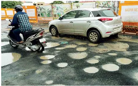
Our topic basically concerns about the safety of road users. Potholes, formed due to heavy rains and movement of heavy vehicles, also become a major reason for traumatic accidents and loss of human lives. As it is seen that many disasters occurring on road are
caused due to potholes and government authorities try hard to fix each and every pothole but due to the preventive measures can be taken on time and a lot of casualties can be reduced from occurring.
II. PROPOSED SYSTEM
Marg-Sudhar is a android based mobile application for reporting potholes and various road anomalies.
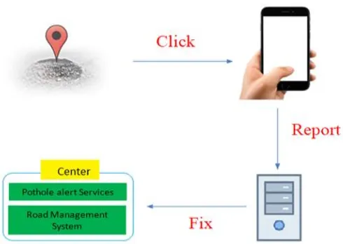
It works on strategy that is “Click”, “Report” and “Fix”. Using app Marg-Sudhar users can click picture which use geotagging technique along with description and this information gets uploaded on server.
The pothole information obtained from pothole reporting system is sent to server and can be applied to a pothole alert service and road management system. All uploaded information are shown as a list view on client side. Also, the obtained pothole information is provided to Road Management System.
III. IMPLEMENTATION
Marg-Sudhar has been implemented using following technologies (1) Android (2) Java (3) SQL (4) Geotagging (5) Web Technologies.
(1) Android:
Android studio is the IDE for google’s Android OS
build on JetBrains’ InteliJ IDEA software and
designed specifically for android development. The following features are provided in the current stable version: Gradel-Based build support, Android-specific refactoring and quick fixes, template-based vizards to create common android designs and components, a rich layout editor that allows user to drag-and-drop UI components, build-in support for google cloud platform, enabling integration with firebase cloud messaging and google app engine.
Fig. 2. Pothole detection system and its application
Application has been implemented on following android features:
• For designing part various activities and their components are used.
• Communication between activities has been implemented using Intent object. Intent is an messaging object use to request an action from another app component.
• Components registration, is an entry point through which the system or a user can enter into app.
• Also, various background services rights has been used.
• This application needs various build app access rights such as: Storage, Camera, Data access, Internet access, GPRS access.
• Data is Authenticated due to security purpose at various point such as at time of login.
(2) Java:
Java is an object-oriented, class-based, concurrent, secured and general-purpose computer-programming language.
(3) Database:
A database is an organised collection of data, generally stored and accessed electronically from a computer system where databases are more complex they are often develop using formal design and modelling techniques.
Android comes with in-built SQLite database. SQLite supports all the relational database features.
(4) Geotagging:
Geotagging or GeoTagging, is the process of adding geographical identification metadata to various media such as a geotagged photographh or video, websites, have a camera with built in GPS or a standalone GPS along with a digital camera.
IV. WORKING
Marg-Sudhar: Pothole reporting system is implemented into two modules: (1) Client side, (2) Server Side.
(1) Client Side:
Fig. 3. Client Side Working
Client side involves user interaction. Using app user can login/ register. If user gets successfully login or register they can click image of pothole. The snapped image is automatically geotagged with latitude & longitude using GPS and GPRS. This image is sent on server along with some description added by user. Additionally, user can also see lists of complaints added by other users and their status.
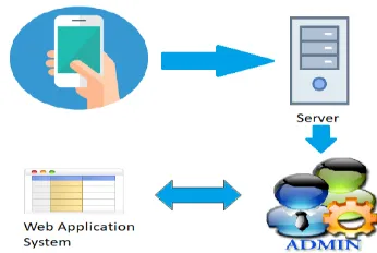
(2) Server Side:
Fig. 4. Server Side Working
V. APPLICATION LAYOUT
(1) Login/ Registration screen:
(2) Home Screen:
(3) Launch Complaint:
(5) Server:
VI. ADVANTAGES & LIMITATIONS
(A) Advantages:
• It becomes easy for road maintainers as well as for locality to monitor the road condition.
• Smooth roads will lead to less vehicle damage and government investment.
• Rapid increase in the rate of Smartphone, users can help to identify Potholes easily.
(B) Limitations:
• To complain on real time basis an android mobile with GPRS connection is required.
• It is completely based on user interaction and using GPS sensors on vehicle
• Further research is necessary for improvement in image processing.
VIII. CONCLUSION
Marg-Sudhar will enable road maintainers to obtain information regarding road condition easily with the help of locality. Through this it will reduce time of Municipal corporation in gathering information and locality will get better roads in less time.
IX. ACKNOWLEDGEMENT
First, and foremost we would like to thank God for the wonderful opportunities and challenges he has given to us. We express our sincere gratitude to our guide Dr. S.V. Sonekar for providing his valuable guidance, patience and for encouraging us to do our best. We wish to thank Prof. P. Lohe, Head, Department of Computer Science and Engineering for his valuable contribution in fulfilling the requirement related to the project.
X. REFRENCES
[1]. Pavan Gorade, Digambar Karde, Poonam Khilare, Abhishek Sontakke, Prof.Ranjana
M.Kedar, “Real Time Pothole Tracking System Using Android Smart Phone”, International
Journal of Advanced Research in Computer Engineering & Technology (IJARCET) Volume 3 Issue 5, May 2014.
[2]. Salman, Waheed Ahmad, Riaz Ali, Salman
Saleem, “a research on mobile applications for
location tracking through web server and short
messages services (sms) “,vfast Transitions on Software Engineering Volume 7, Number 02, July-August, 2015.
[3]. Lizeth Chandi, Catarina Silva, “Mobile
application development process: A practical
experience”.
[4]. Seung-Ki Ryu,1 Taehyeong Kim,1 and
Mathematical Problems in Engineering Volume 2015.
Cite this article as :
Riya Agrawal, Payal Patel, Yash Telang, Ankita Bhandarkar, Irfan Mushtaq, Dr. S. V. Sonekar, "Marg-Sudhar : Pothole Reporting System Using Android Smart Phone", International Journal of Scientific Research in Computer Science, Engineering and Information Technology (IJSRCSEIT), ISSN : 2456-3307, Volume 5 Issue 1, pp. 197-202, January-February 2019.