ISSN 2286-4822 www.euacademic.org
Impact Factor: 3.1 (UIF)
DRJI Value: 5.9 (B+)
A Study of Irrigation Pattern in Nanded District of
Maharashtra State
DR. PARAG ARUN KHADKE Assistant Professor and Research Guide School of Earth Sciences Swami Ramanand Teerth Marathwada University Nanded, Maharashtra India VARSHA MANATHKAR PRAMOD BABURAO WAGHMARE
Research Scholars School of Earth Sciences Swami Ramanand Teerth Marathwada University Nanded, Maharashtra India
Abstract:
The present study has aimed to explain the Irrigation patterns of Nanded district during 1984-85 to 2009-10. Irrigation is an artificial supply of water to land for growing crops and to increase the per hector yield. Irrigation is necessary particularly in and uncertain rainfall areas. It is essential and artificial application of water to overcome the deficiencies in rainfall for growing crops (Contour 1967). Irrigation plays a vital role in meeting rising demands of food and fodder for growing human diestock population; moreover it is an age old practice of ancient civilization design to reduce moisture deficiency. Investment in irrigation leads to multiple benefits such as it enables farmer to harvest two or three crops a year. It is in this contest that the present study of irrigation and its impact on cultivated area in Nanded district of Maharashtra is under taken.
Introduction:
The present study has aimed to explain the Irrigation patterns and spatio -temporal changes Irrigation in Nanded district. Agricultural is one of the most important occupations of the study area. Nearly 78.13% of working population is directly engaged in agricultural activities. The Economy of the study region mainly depends on agricultural. The modern agricultural implements is improved or hybrids seeds use of different pesticides, insecticides. Weed sides, fungicides and irrigation facilities have increase agricultural production of the study region. Agriculture is more prosperous in the areas of various river basin i.e Godavari, Manjara, Manyad, Sarswati Penganga, Asana, Sita, and lendi etc. Irrigation being artery and pulsing heart is an absolute, constant as well as a sufficient command over the location of commercial crops important in agricultural production per hectare, showing in the cropping pattern change in the technique in the land use of a region since many decades.
Objectives:
1) To analyze the Irrigation patterns in Nanded district. 2) To find the Sources of Irrigation in Nanded district. 3) To calculate the change occur in irrigation from 1984 to
2010
Study Area:
North latitude and 77°.7' to 78°.15' East longitudes. The total population of the districts was 33, 56,566 persons according to 2011 census.
Data Base and Methodology:
The present study is based on secondary data collected from census Reports of Government of India. Agriculture Departments of Zillah Perished, Agriculture office of Nanded district. The District Gazetteer of Nanded 1971. Socio-Economic Review and District Statistical Abstracts of Nanded district 1985, 1999, 2001, 2006, 2010. Various Agricultural bulletins, periodicals, Newspaper, Journals. The extensive fieldwork was under taken for investigation of irrigation and degradation of soils.
Current Year – Base Year
Change = --- X 100 Base Year
Sources of Irrigation:
1) Well Irrigation 2) Surface Water Irrigation 3) Other sources of irrigation
WELL IRRIGATION:
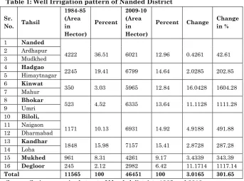
Table 1: Well Irrigation pattern of Nanded District
Sr.
No. Tahsil
1984-85 (Area in Hector) Percent 2009-10 (Area in Hector)
Percent Change Change
in %
1 Nanded
4222 36.51 6021 12.96 0.4261 42.61 2 Ardhapur
3 Mudkhed
4 Hadgao
2245 19.41 6799 14.64 2.0285 202.85 5 Himaytnagar
6 Kinwat
350 3.03 5965 12.84 16.0428 1604.28 7 Mahur
8 Bhokar
523 4.52 6335 13.64 11.1128 1111.28 9 Umri
10 Biloli,
1171 10.13 6931 14.92 4.9188 491.88 11 Naigaon
12 Dharmabad
13 Kandhar
1848 15.98 7157 15.41 2.8728 287.28 14 Loha
15 Mukhed 961 8.31 4261 9.17 3.4339 343.39
16 Degloor 245 2.12 2982 6.42 11.1714 1117.14
Total 11565 100 46451 100 3.0165 301.65
Source: Socio-economic abstract of Nanded districts 1985 and 2010
Degloor has comparative less hectors of land under well irrigation. According to the year 1984-85 statistics well irrigation it was more in every region of study region. In some areas it was less but now days it is showing increasing trend.
SURFACE WATER IRRIGATION:
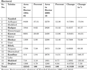
Table 2: Surface Water Irrigation pattern of Nanded District (Area in Hectors)
Sr. No.
Taluka Area
in Hector 1984-85
Percent Area in Hector 2009-10
Percent Change Change in %
1 Nanded
8456 37.51 2279 12.36 -0.7304 -73.04 2 Ardhapur
3 Mudkhed
4 Hadgao 1944 8.62 2826 15.32 0.4537 45.37
5 Himaytnagar
6 Kinwat 6691 29.68 2408 13.06 -0.6401 -64.01
7 Mahur
8 Bhokar 1308 5.80 2298 12.46 0.7568 75.68
9 Umri
10 Biloli,
1708 7.58 2873 15.58 0.6850 68.50 11 Naigaon
12 Dharmabad
13 Kandhar 414 1.84 2676 14.51 5.4637 546.37
14 Loha
15 Mukhed 718 3.18 1801 9.77 1.5083 150.83
16 Degloor 1306 5.79 1280 6.94 -0.0750 -7.50
Total 22545 100 18441 100 -0.1820 -18.20
Source: Socio-economic abstract of Nanded districts 1985 and 2010
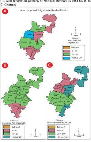
Surface water irrigation is very useful and traditional practice in Nanded districts because of the Godavari River. During the year 1984–85 there was very less hector of land under surface water irrigation. There was drastic change in this irrigation pattern in the year 2009-10. There is reduction in area under well irrigation in Nanded, Kinwat and Degloor taluka because of other sources of irrigation like canal built in the year 2009-10.
other taluka. Kandhar taluka has comparative less hectors of land under surface water irrigation in the year 1984-85. Degloor taluka has comparative less hectors of land under surface water irrigation in the year 2009-10. According to the year 1984-85 statistics surface water irrigation it was more in every region of study region. In some areas it was less but now days it is showing increasing trend.
Fig. 2: Surface Water Irrigation pattern of Nanded District (A-1984-85, B- 2009-10, C- Change)
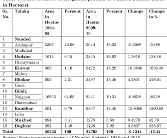
Table 3: Other Sources of Irrigation pattern of Nanded District (Area in Hectors)
Sr. No.
Taluka Area
in Hector 1984-85
Percent Area in Hector 2009-10
Percent Change Change in %
1 Nanded
5367 20.08 3640 16.03 -0.3089 -30.89 2 Ardhapur
3 Mudkhed
4 Hadgao 1614 6.15 3845 16.93 1.3816 138.16
5 Himaytnagar
6 Kinwat 305 1.16 3472 15.29 10.3836 1038.36
7 Mahur
8 Bhokar 605 2.31 3497 15.40 4.7801 478.01
9 Umri
10 Biloli,
16953 64.62 2341 10.31 -0.8619 -86.19 11 Naigaon
12 Dharmabad
13 Kandhar 204 0.78 2837 12.49 12.9068 1290.68
14 Loha
15 Mukhed 894 3.41 1278 5.63 0.4279 42.79
16 Degloor 392 1.49 1798 7.92 3.5867 358.67
Total 26235 100 22708 100 -0.1344 -13.44
Source: Socio-economic abstract of Nanded districts 1985 and 2010
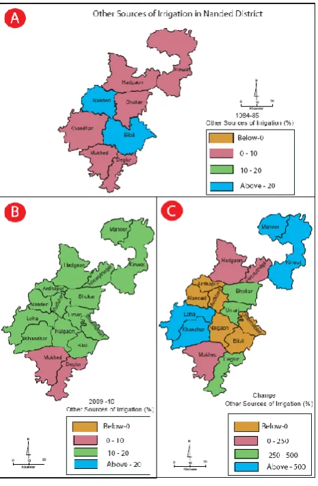
Other sources of irrigation consist Rainfall and moisture in the area in the study area where there is no chance to gate water from canal or lift irrigation and also well are not possible in such area, rain is the one and only one source of irrigation these area can be bring under lift irrigation. Other sources of irrigation are very useful in the rain fed areas in Nanded district.
During the year 1984–85 there was more hector of land under other source of irrigation. There is reduction in area under other source of irrigation in Nanded and Biloli taluka because of urbanization and change in irrigated land to other purpose in the year 2009-10.
Kandhar taluka in the year 1984-85 (0.78%), but it is drastically increased in year 2009-10 (12.49%) as compare to other taluka. Kandhar taluka has comparative less hectors of land under surface water irrigation in the year 1984-85. Mukhed taluka has comparative less hectors of land under surface water irrigation in the year 2009-10. According to the year 1984-85 statistics other source of irrigation it was more in every region of study region. In some areas it was less but now days it is showing increasing trend.
References:
Bouman, Hani. 1975. “Irrigation Development in Semiarid Areas.” Applied Science and Development 5: 720.
Cantor, L.M. 1967. A World Geography of Irrigation. London: Olner and Boxt.
Census of India. District Census Handbook, Nanded, 1991, 2001 and 2011.
Friman, David. 1952. “General Aspect of Geography of Irrigation in India.” The Geographer 5(2): 1-11.
Daxal. 1977. “Impact of Irrigation Expansion on Multiple Cropping in India.” Tidschrifte Voor, Economic and
Social Geography 88: 100-109.
Dhillon, S.S. and Sandhu, Devindar. 1979. “Irrigation Development in Punjab, Its potential and limitation (1951-52 to 1975-76).” Geographical Review of India
41(2): 155- 172.
Gujar, R.K. 1987. Irrigation for Agricultural Modernization
Jodhapur: Scientific Publisher, page 105.
Kulkarni, D.G. 1970. River Basins of Maharashtra Problems of
Irrigated Agriculture. Pune: Orient Longman.
Maharashtra State Gazetteer. 2001. Nanded District.
More, K. S. and Mustfa, F.R. 1984. “Irrigation Requirement and Development in Maharashtra.” Transactions of Institute
of Indian Geography 6(2): 73-78.
Pawar, C.T. 1985. “Regional Disparities in Irrigation Development – A Case Study of Maharashtra.” Unpublished Research Project, submitted to Shivaji University Kolhapur, page 19- 26.
Priher, S.S. and Sandhu, B.S. 1987. “Irrigation of Field Crops- Principles and Practices.” Indian Council of Agricultural Research, Krushi Anusthan Bhavan – New Delhi, page 58.
Wagh, A.S. 2009. Irrigation and its impact on cultivated area. A