Adv. Radio Sci., 6, 71–75, 2008 www.adv-radio-sci.net/6/71/2008/
© Author(s) 2008. This work is distributed under the Creative Commons Attribution 3.0 License.
Advances in
Radio Science
Optimized tracking for cooperative sensor systems in multipath
environments
D. Schwarz1, R. H. Rasshofer1, and E. M. Biebl2
1BMW Group Research and Technology, Munich, Germany
2Fachgebiet H¨ochstfrequenztechnik, Technische Universit¨at M¨unchen, Germany
Abstract. In a cooperative sensor system for pedestrian pro-tection, a pedestrian and other road users exchange data by means of radio frequency communication. In the proposed system, the pedestrian carries a transponder which is inter-rogated by a vehicle and sends an anonymous identification (ID) sequence. By decoding the ID, the interrogation unit in the vehicle detects the presence of the transponder. Evaluat-ing the incident wave of the transponder’s answer, a localisa-tion is possible.
In the proposed localization system, the measurement re-sults can be distorted by multipath propagation. Multipath errors result if signals of the same transponder arrive simul-taneously at the receiver unit from different directions. In this case, erroneous distances and angles are measured. Be-cause the signals arriving from different directions contain the same transponder ID, they can be assigned to their ori-gin. One of the challenges in post-processing for signal im-provement is enhancing the selection of the correct position information by making assumptions about the pedestrian’s movement and by knowing the vehicle’s current driving pa-rameters. Additionally, information contained in multipath signals is used to form a better estimate for the true posi-tion of the transponder. To overcome the problems related to multipath propagation effects, a method is proposed that esti-mates the origin of a multipath signal and maps the distorted position information back to the true position. A fusion of tracked direct positions and mapped multipath signals leads to an improvement in positioning accuracy.
1 Introduction
Pedestrian detection approaches based on lidar (F¨urstenberg, 2004), radar, or vision-based systems (Gavrila et al., 2004) offer highly accurate positioning information of objects or persons in the vehicle’s surroundings. The reliability of these
Correspondence to: D. Schwarz
systems has been improved rapidly using new detection, clas-sification and fusion algorithms (Paraschoudis et al., 2006). Current systems are already capable to cover a large number of typical accident scenarios. In scenarios where pedestrians are fully or partially hidden to these sensors either their de-tection or their correct classification might fail. The results of accident studies show that 40% of all fatal pedestrian acci-dents in Germany are caused by a late recognition of the situ-ation by the driver (German In-Depth-Accident Study, 2005). In these cases, a cooperative sensor system could support ac-tive safety systems with valuable information. A pedestrian that is occluded to the view of the driver and sensors built in the vehicle can be detected earlier which provides more time for triggering collision avoidance and collision mitiga-tion systems.
1.1 Related work
In Shi et al. (2005) a proposed cooperative system determines the DoA of an incident transponder signal. The distance is not measured directly but through triangulation using the de-tected DoAs at two subsequent locations while the vehicle is moving.
Meinken et al. (2007) describe a cooperative system for traffic safety based on communication and sensor technolo-gies. The concept relies on interactions between an in-vehicle module and a user’s device. Positioning is done by two communication-based distance measurements between the rear-view mirrors and the transponder (Sikora, 2006). Through triangulation the position can be calculated.
Other previous work that mention cooperative systems use infrastructure devices as repeaters (Kubota et al., 2006) but do not use a localisation system integrated into a vehicle. 1.2 Content
First, the integrated localisation system in the test vehicle is introduced and measurement principles are described in more detail. The influences of multipath propagation on measurement results are pointed out in Sect. 3. To overcome the drawbacks caused by multipath effects, requirements on
72 D. Schwarz et al.: Optimized tracking for cooperative sensor systems in multipath environments
3
2 System Overview
Fig. 1:Interrogation pulse of vehicle in an urban scenario (left), answer pulse of a transponder hidden to the driver between parked cars
2.1 On Board Unit
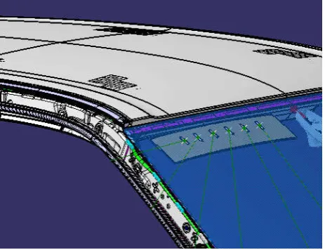
A central part of the system is an antenna array which is integrated behind the wind shield of the vehicle. The antenna array is used to send an interrogation pulse and to receive the answer from the transponder to be localized. Data samples of the single antenna elements are used for the detection of an object’s presence and determination of the object position. The driver’s field of view is not affected by the integrated antennas and no modifications need to be made to the car body or design of the test vehicle (see Fig. 2).
The initial design of the system will utilize ISM bands to ease international licensing. As each ISM band offers different channel properties, three different ISM bands have been experimentally investigated (434 MHz, 868 MHz and 2.4 GHz). Communication with a transponder being optically hidden behind a car represents one of the most challenging scenarios. With all three frequencies the received signal strength from a transponder showed to be strong enough for a reliable detection, even in worst case scenarios. To minimize the antenna array’s size, 2.4 GHz has been chosen as operating frequency. Switching to the IEEE 802.11p standard at 5.9 GHz, intended for Car-to-Car (C2C) communication, even would lead to a further reduction of the antenna size.
Fig. 1. Interrogation pulse of vehicle in an urban scenario (left), answer pulse of a transponder hidden to the driver between parked cars.
4
Fig. 2:
3D model of antenna array integrated behind the front window of test vehicle
2.1.1 Direction-of-Arrival (DoA)
Using six antennas in the antenna array, an estimation of the DoA can be obtained. If a valid
signal sent by a transponder is identified, the amplitudes and phases of the antenna voltages
are sampled and used to derive the DoA. Different well-known high resolution DoA
estimation algorithms like ESPRIT (Estimation of Signal Parameters via Rotational Invariant
Techniques) or MUSIC (Multiple Signal Classification) [9] are investigated and applied to the
raw data to obtain reliable azimuth angle data. In the first measurements, the transponder’s
azimuth angle could be estimated with an accuracy of about 1 degree in different distances in
the case of a Line-of-Sight (LoS) connection. As expected, the accuracy of the angular
measurement decreases without a LoS connection. Tests show the possibility of improving
the localisation accuracy, depending on SNR and multipath scenario, by applying suitable
tracking algorithms in a post-processing step.
2.1.2 Time-of-Flight (ToF)
The tag’s distance can be calculated by a ToF measurement, determining the round trip delay
of the interrogation pulse. Furthermore, the change of the measured azimuth angle can be
investigated knowing the vehicle’s velocity to achieve more accurate positioning [5]. The ToF
measurement is done by means of a subcarrier technique. The received interrogation sequence
is decoded and, after a certain time-delay, a response is sent containing information about the
time delay and the ID-code [10]. Knowing the delay time and the time between interrogation
pulse and received answer, the distance can be calculated. Since each tag uses a different
time-delay, TDMA techniques are applied to allow for separation of the responses from
Fig. 2. 3-D model of antenna array integrated behind the frontwin-dow of test vehicle.
a robust tracking algorithm are deduced, and in Sect. 4 an example for an algorithm which is able to deal with multi-path effects is introduced. An outlook on further work and a conclusion are presented in the final sections.
2 System overview 2.1 On board unit
A central part of the system is an antenna array which is in-tegrated behind the wind shield of the vehicle. The antenna array is used to send an interrogation pulse and to receive the answer from the transponder to be localized. Data samples of the single antenna elements are used for the detection of an object’s presence and determination of the object position.
5 several tags. Without superposition of different responses the precision of both ToF and DoA
measurements is enhanced.
2.2 Transponder
If the transponder identifies a valid interrogation pulse, it changes into an active state and
starts transmitting. This wake up mechanism is suitable to reduce the power consumption and
to extend battery lifetime. Another promising approach features the integration of acceleration
sensors to shut down the transponder if it is not moved for a longer time and thus is unlikely
to be carried by a pedestrian.
antenna
receiver
transmitter
CPU
Power supply
Long- range T ag
Interrogation Unit (vehicle)
100m
Wake-Up
Electromagnetic wave
FLASH RAM
µC A/D
Fig. 3:Interaction between interrogation unit and transponder
3 Multipath Effects In The Cooperative Sensor System
A tracking system for cooperative sensor data needs to deal with multipath propagation of the
transponder signals. As sudden strong interferences in the measured position caused by these
effects can not be modelled as Gaussian noise, a standard Kalman-Filter [11] is not the
optimal solution for tracking purposes.
Fig. 4:Correct position of pedestrian is measured (left), multipath signals caused by reflection
at a wall lead to different ToF and DoA measurements (right)
Fig. 3. Interaction between interrogation unit and transponder.
The driver’s field of view is not affected by the integrated an-tennas and no modifications need to be made to the car body or design of the test vehicle (see Fig. 2).
The initial design of the system will utilize ISM bands to ease international licensing. As each ISM band offers dif-ferent channel properties, three difdif-ferent ISM bands have been experimentally investigated (434 MHz, 868 MHz and 2.4 GHz). Communication with a transponder being opti-cally hidden behind a car represents one of the most challeng-ing scenarios. With all three frequencies the received signal strength from a transponder showed to be strong enough for a reliable detection, even in worst case scenarios. To minimize the antenna array’s size, 2.4 GHz has been chosen as oper-ating frequency. Switching to the IEEE 802.11p standard at 5.9 GHz, intended for Car-to-Car (C2C) communication, even would lead to a further reduction of the antenna size. 2.1.1 Direction-of-Arrival (DoA)
Using six antennas in the antenna array, an estimation of the DoA can be obtained. If a valid signal sent by a transpon-der is identified, the amplitudes and phases of the antenna voltages are sampled and used to derive the DoA. Differ-ent well-known high resolution DoA estimation algorithms like ESPRIT (Estimation of Signal Parameters via Rotational
D. Schwarz et al.: Optimized tracking for cooperative sensor systems in multipath environments 73
5
several tags. Without superposition of different responses the precision of both ToF and DoA
measurements is enhanced.
2.2 Transponder
If the transponder identifies a valid interrogation pulse, it changes into an active state and
starts transmitting. This wake up mechanism is suitable to reduce the power consumption and
to extend battery lifetime. Another promising approach features the integration of acceleration
sensors to shut down the transponder if it is not moved for a longer time and thus is unlikely
to be carried by a pedestrian.
antenna
receiver
transmitter
CPU
Power supply
Long- range T ag
Interrogation Unit (vehicle)
100m
Wake-Up
Electromagnetic wave
FLASH
RAM µC A/D
Fig. 3:
Interaction between interrogation unit and transponder
3
Multipath Effects In The Cooperative Sensor System
A tracking system for cooperative sensor data needs to deal with multipath propagation of the
transponder signals. As sudden strong interferences in the measured position caused by these
effects can not be modelled as Gaussian noise, a standard Kalman-Filter [11] is not the
optimal solution for tracking purposes.
Fig. 4:
Correct position of pedestrian is measured (left), multipath signals caused by reflection
at a wall lead to different ToF and DoA measurements (right)
Fig. 4. Correct position of pedestrian is measured (left), multipath signals caused by reflection at a wall lead to different ToF and DoA
measurements (right).
6
In a first approach, the position data corrupted by multipath phenomena are tried to be
removed by a tracking procedure. However, measurements showed that there is useful
information contained in multipath signals, including information about the moving direction
of the transponder, which, if also utilized, can lead to a better positioning accuracy.
Fig. 5:
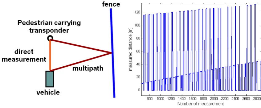
Measurement setup for cooperative sensor system (left), distance measurement results:
multipath propagation causes ambiguity, distance ranges 10-40m or 110-130m (right)
4 Adapted
Tracking
Algorithms
4.1 Kalman-Filter With Plausibility Check
Looking at Fig. 5, a first approach to compensate for multipath effects could be to sort out all
measurements influenced by multipath propagation. This is done by a plausibility check of the
data when looking at several subsequent measurements. The remaining measurement points
are - in this simple case - sufficient for a stable tracking with a Kalman-Filter using a system
model with constant velocity (CV) for the pedestrian.
However, it can be seen easily that the erroneous measurement values in a range between 110
and 130 meter are increasing similar to the correct measurement points. They indicate a
movement of the pedestrian away from the car. The existence of the multipath data in this
case can almost completely be explained by a reflection of the transponder signal at a fence
near by the measurement setup. As influences on the DoA measurement showed similar
results and some interferences could be explained by a simple reflection at planar obstacles, a
Fig. 5. Measurement setup for cooperative sensor system (left), distance measurement results: multipath propagation causes ambiguity,
distance ranges 10–40 m or 110–130 m (right).
Invariant Techniques) or MUSIC (Multiple Signal Classifi-cation) (Schmidt, 1987) are investigated and applied to the raw data to obtain reliable azimuth angle data. In the first measurements, the transponder’s azimuth angle could be es-timated with an accuracy of about 1◦in different distances in the case of a Line-of-Sight (LoS) connection. As expected, the accuracy of the angular measurement decreases without a LoS connection. Tests show the possibility of improving the localisation accuracy, depending on SNR and multipath scenario, by applying suitable tracking algorithms in a post-processing step.
2.1.2 Time-of-Flight (ToF)
The tag’s distance can be calculated by a ToF measurement, determining the round trip delay of the interrogation pulse. Furthermore, the change of the measured azimuth angle can be investigated knowing the vehicle’s velocity to achieve more accurate positioning (Shi et al., 2005). The ToF mea-surement is done by means of a subcarrier technique. The received interrogation sequence is decoded and, after a
cer-tain time-delay, a response is sent concer-taining information about the time delay and the ID-code (Rasshofer et al., 2007). Knowing the delay time and the time between interrogation pulse and received answer, the distance can be calculated. Since each tag uses a different time-delay, TDMA techniques are applied to allow for separation of the responses from sev-eral tags. Without superposition of different responses the precision of both ToF and DoA measurements is enhanced. 2.2 Transponder
If the transponder identifies a valid interrogation pulse, it changes into an active state and starts transmitting. This wake up mechanism is suitable to reduce the power con-sumption and to extend battery lifetime. Another promis-ing approach features the integration of acceleration sensors to shut down the transponder if it is not moved for a longer time and thus is unlikely to be carried by a pedestrian.
74 D. Schwarz et al.: Optimized tracking for cooperative sensor systems in multipath environments
7
new approach has been chosen. For further studies and the development of algorithms
simulations have been conducted to generate a large number of scenarios.
4.2 Mapping of Multipath Signals
As an example for the various simulations conducted, a setup as shown in Figure 6 should be
considered. A moving vehicle determines the position of a pedestrian moving with a different
velocity using the cooperative sensor system. After some simulation time the pedestrian is
occluded to the vehicle and due to multipath signals the wrong position is observed in
subsequent measurements.
Fig. 6:
Example for simulation setup
During the occlusion - if multipath signals are neglected - only a prediction of the pedestrian's
movement can be done by the last estimated velocity vector. Changes in the moving direction
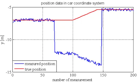
can not be recognized in this case. Fig. 7 shows position data received in this scenario.
Fig. 7:
Simulation data of scenario shown in Fig. 6
In this approach, a rule-based algorithm detects the sudden change of position data. The
position of the pedestrian is predicted using a Kalman-Filter with constant velocity model and
for the multipath data, a new track is generated. With the simple assumption that one
reflection plane is responsible for the multipath signal, the algorithm tries to calculate the
Fig. 6. Example for simulation setup.
7
new approach has been chosen. For further studies and the development of algorithms
simulations have been conducted to generate a large number of scenarios.
4.2 Mapping of Multipath Signals
As an example for the various simulations conducted, a setup as shown in Figure 6 should be
considered. A moving vehicle determines the position of a pedestrian moving with a different
velocity using the cooperative sensor system. After some simulation time the pedestrian is
occluded to the vehicle and due to multipath signals the wrong position is observed in
subsequent measurements.
Fig. 6:
Example for simulation setup
During the occlusion - if multipath signals are neglected - only a prediction of the pedestrian's
movement can be done by the last estimated velocity vector. Changes in the moving direction
can not be recognized in this case. Fig. 7 shows position data received in this scenario.
Fig. 7:
Simulation data of scenario shown in Fig. 6
In this approach, a rule-based algorithm detects the sudden change of position data. The
position of the pedestrian is predicted using a Kalman-Filter with constant velocity model and
for the multipath data, a new track is generated. With the simple assumption that one
reflection plane is responsible for the multipath signal, the algorithm tries to calculate the
Fig. 7. Simulation data of scenario shown in Fig. 6.
3 Multipath effects in the cooperative sensor system A tracking system for cooperative sensor data needs to deal with multipath propagation of the transponder signals. As sudden strong interferences in the measured position caused by these effects can not be modelled as Gaussian noise, a standard Kalman-Filter (Kalman, 1960) is not the optimal so-lution for tracking purposes.
In a first approach, the position data corrupted by multi-path phenomena are tried to be removed by a tracking pro-cedure. However, measurements showed that there is useful information contained in multipath signals, including infor-mation about the moving direction of the transponder, which, if also utilized, can lead to a better positioning accuracy.
4 Adapted tracking algorithms
4.1 Kalman-Filter with plausibility check
Looking at Fig. 5, a first approach to compensate for multi-path effects could be to sort out all measurements influenced by multipath propagation. This is done by a plausibility check of the data when looking at several subsequent mea-surements. The remaining measurement points are – in this simple case – sufficient for a stable tracking with a
Kalman-Filter using a system model with constant velocity (CV) for the pedestrian.
However, it can be seen easily that the erroneous measure-ment values in a range between 110 and 130 m are increasing similar to the correct measurement points. They indicate a movement of the pedestrian away from the car. The existence of the multipath data in this case can almost completely be explained by a reflection of the transponder signal at a fence near by the measurement setup. As influences on the DoA measurement showed similar results and some interferences could be explained by a simple reflection at planar obstacles, a new approach has been chosen. For further studies and the development of algorithms simulations have been conducted to generate a large number of scenarios.
4.2 Mapping of multipath signals
As an example for the various simulations conducted, a setup as shown in Fig. 6 should be considered. A moving vehicle determines the position of a pedestrian moving with a differ-ent velocity using the cooperative sensor system. After some simulation time the pedestrian is occluded to the vehicle and due to multipath signals the wrong position is observed in subsequent measurements.
During the occlusion – if multipath signals are neglected – only a prediction of the pedestrian’s movement can be done by the last estimated velocity vector. Changes in the moving direction can not be recognized in this case. Figure 7 shows position data received in this scenario.
In this approach, a rule-based algorithm detects the sud-den change of position data. The position of the pedestrian is predicted using a Kalman-Filter with constant velocity model and for the multipath data, a new track is generated. With the simple assumption that one reflection plane is responsi-ble for the multipath signal, the algorithm tries to calculate the parameters of this plane. As measurements showed, this assumption holds true in many scenarios. The movement of the pedestrian can be predicted quite accurately in the first few hundred milliseconds due to physical limitations like e.g. maximum possible acceleration. If a relation between the predicted position and the tracked multipath position can be found and the reflection plane is observed to be stable for a
D. Schwarz et al.: Optimized tracking for cooperative sensor systems in multipath environments 75
8
parameters of this plane. As measurements showed, this assumption holds true in many
scenarios. The movement of the pedestrian can be predicted quite accurately in the first few
hundred milliseconds due to physical limitations like e.g. maximum possible acceleration. If a
relation between the predicted position and the tracked multipath position can be found and
the reflection plane is observed to be stable for a few cycles, one can start to map back the
data to their origin. In the following cycles, the position of the plane in the car coordinate
system needs to be updated taking into account the driving parameters of the vehicle, like e.g.
velocity or yaw rate. Results are shown in Fig. 8.
Fig. 8:
Comparison between prediction using a Kalman-Filter (left) and the proposed
algorithm for multipath data (right)
This way information, like changes in moving direction, contained in multipath data is
interpreted and used for a more robust and stable estimation of the pedestrian’s position.
5 Further
Work
Future work should start by adopting algorithmic parameters using measurement data from
test scenarios. Increased detection accuracy of a sudden change between a direct signal and a
multipath signal should be achieved by taking the received signal strength as additional input.
In the proposed system one position information per cycle was used as input. In the next step,
several hypotheses for the position should be used as the measurement principles are able to
provide more than one value per cycle. This data can be handled with particle filters based on
Sequential Monte Carlo Methods (SMCM) [12] combined with the proposed mapping
algorithm.
6 Conclusions
A system for pedestrian detection based on cooperative sensor technology has been
introduced. The influence of multipath propagation on the system was investigated using ToF
and DoA measurement results. A tracking algorithm takes these effects into account and uses
Fig. 8. Comparison between prediction using a Kalman-Filter (left) and the proposed algorithm for multipath data (right).
few cycles, one can start to map back the data to their origin. In the following cycles, the position of the plane in the car co-ordinate system needs to be updated taking into account the driving parameters of the vehicle, like e.g. velocity or yaw rate. Results are shown in Fig. 8.
This way information, like changes in moving direction, contained in multipath data is interpreted and used for a more robust and stable estimation of the pedestrian’s position.
5 Further work
Future work should start by adopting algorithmic parameters using measurement data from test scenarios. Increased de-tection accuracy of a sudden change between a direct signal and a multipath signal should be achieved by taking the re-ceived signal strength as additional input.
In the proposed system one position information per cycle was used as input. In the next step, several hypotheses for the position should be used as the measurement principles are able to provide more than one value per cycle. This data can be handled with particle filters based on Sequential Monte Carlo Methods (SMCM) (Doucet et al., 2001) combined with the proposed mapping algorithm.
6 Conclusions
A system for pedestrian detection based on cooperative sen-sor technology has been introduced. The influence of mul-tipath propagation on the system was investigated using ToF and DoA measurement results. A tracking algorithm takes these effects into account and uses a model for the origin of multipath signals. Simulations showed the feasibility of the multipath compensation by mapping erroneous position information back to their origin for an improvement of posi-tioning accuracy.
Acknowledgements. The cooperative sensor system presented in this publication is part of the main efforts in the AMULETT-project which is co-funded by the Bavarian Ministry of Economic Af-fairs, Infrastructure, Transport and Technology (BayStMWIVT). The project aims to avoid accidents involving vulnerable road users
such as pedestrians and bicyclists by means of cooperative sensor technology.
References
Doucet, A., de Freitas, N., and Gordon, N. (Eds.): Sequential Monte Carlo Methods in Practice, Springer, 2001.
F¨urstenberg, K. Ch.: Pedestrian Protection using Laserscanners, IEEE Conference on Intelligent Transportation Systems, 436– 437, 2005.
Gavrila, D. M., Giebel, J., and Munder, S.: Vision-Based Pedestrian Detection: The PROTECTOR System, IEEE Intelligent Vehicles Symposium, 13–18, 2004.
German In-Depth-Accident Study: http://www.gidas.org, 2005. Kalman, R. E.: A New Approach to Linear Filtering and Prediction
Problems, J. Basic Eng.-T. ASME, 82 (Series D), 35–45, 1960. Kubota, S., Okamoto, Y., and Oda, H.: Safety Driving Support
System Using RFID for Prevention of Pedestrian-involved Acci-dents, 6th International conference on ITS Telecommunications Proceedings, 226–229, 2006.
Meinken, K., Andreone, L., Guarise, A., and Sikora, A.: WATCH-OVER – The Concept Of A Cooperative System For Vehicle To Vulnerable Road Users Communication, 20th International Tech-nical Conference on the Enhanced Safety of Vehicles, 07-0126, 2007.
Paraschoudis, V., Tatschke, T., Walchshaeusl, L., and Lindl, R.: Au-tonomous braking for collision mitigation purposes by means of multi sensor perception, FISITA World Automotive Congress, F2006V181, 2006.
Rasshofer, R., Schwarz, D., Biebl, E., Morhart, C., Scherf, O., Zecha, S., Gr¨unert, R., and Fr¨uhauf, H.: Pedestrian Protection Systems using Cooperative Sensor Technology, Proceedings of the 11th International Forum on Advanced Microsystems for Au-tomotive Applications (AMAA’07), Berlin, 135–145, 2007. Schmidt, R. O.: Multiple Emitter Location and Signal Parameter
Estimation, IEEE T. Antenn. Propag., 34, 276–280, 1987. Sikora, A.: Vehicle-to-Vulnerable road user cooperative
communi-cation and sensing technologies to improve transport safety, D4.1 – Communication technologies specifications, 2006.
Shi, J., M¨uller, H. C., and Marx, M.: Pedestrian Detection and Lo-calization Using Antenna Array and Sequential Triangulation, IEEE Conference on Intelligent Transportation Systems, Vienna, 126–130, 2005.