w w w . i j m r e t . o r g I S S N : 2 4 5 6 - 5 6 2 8 Page 23
Applicability Study on the Optical Remote Sensing
Techniques in a River
Yeo HongKoo
1, Kim JongTae
2*, Kim JiHyun
11
(Department of Land, Water and Environment Research, Korea Institute of Civil Engineering and Building Technology, Republic of Korea)
2
(Nature & Technology Inc., Republic of Korea)
ABSTRACT : Since the recent development of UAVs(Unmanned Aerial Vehicles) and digital sensors technology has enabled the acquisition of high-resolution image data, it is considered that the image data of riverside can be analysed. Therefore, this study analyses the applicability of remote sensing techniques through image analysis in river systems and habitats. The target stream in this study was the Cheongmi stream and the applicability of the river environmental evaluation technique was analysed through image analysis. The satellite images used for the analysis of river topography and environments were compared with the aerial images taken by a micro UAV), and the river environmental evaluation was carried out with the field research at the same time. The data acquisition range and application limit by river environmental evaluation technique proposed previously were evaluated, and as a result, it was found that it was possible to draw various evaluation parameters using a drone that could take an image at a low altitude in comparison to satellite images.
KEYWORDS:GIS, image, optical remotesensing techniques, river, UAV
I. INTRODUCTION
River environmental management encompasses various activities to optimize the environmental function of the river, such as flood control and water conservation of rivers, nature conservation and restoration, and creation of waterfront spaces, and to preserve or create natural and social environmental functions by minimizing the adverse effects. According to a recent global environmental outlook, biodiversity and renewable natural resources are in a serious or critical condition due to climate change and urbanization [1-2].
The OECD Environmental Outlook to 2030 designates climate change, biodiversity loss, water scarcity, environmental pollution and hazardous chemicals as priority environmental issues. In other words, it is time to take measures to deal with the shortage of environmental ecological flow caused by sophisticated land use, the expansion of cities, reduction of the maintenance of the river and the flood plain, the reduced restoration elasticity of protected lowlands, obstacles to the continuity of rivers such as dams, overuse of water resources in the basin, change of the water circulation system, and deterioration of river floating matter.
Major developed countries including the U.S., the European countries, Australia and Japan have been intensively developing and utilizing river ecosystem conservation and restoration policies to
cope with climate change, increase biodiversity and restore species, promoting the accumulation and development of scientific knowledge related to the river environment as a sustainable mid-term and long term task. In Korea, active investment and efforts are needed to investigate and manage the river environment scientifically in terms of physics, chemistry, and biology in order to improve the river environment in each basin unitso that the diversity of river ecosystems can be secured. To address these diverse issues that are happening today, field research has been conducted. But the research that can be conducted by humans in the field has its limitations. For this reason, it is necessary to apply various techniques such as optical remote sensing technology, which is being rapidly developed to the river environment field [3-6].
w w w . i j m r e t . o r g I S S N : 2 4 5 6 - 5 6 2 8 Page 24
analysis of spatial phenomena that could not have been attempted through temporal analysis and existing mapping techniques in connection with GIS has been performed, providing the advantages of a faster and more accurate analysis at a lower cost [7].
In the maritime sector, remote sensing has been carried out in various parts of the world in relation to analysis of changes in the coastal zone and depth measurement. Much more progress has been made in coastal and hydroponic environments, where the benefits of remote sensing compared to field measurements are more pronounced [8-10]. However, research that extends the remote sensing technology to the river analysis to understand the water depth and temperament characteristics of the coastal environmenthasnotbeen actively pursued.
This is because in general, optical remote sensing, satellite images and aerial images of rivers, which are relatively narrow areas, have low resolution. Since the recent development of UAV technology has enabled the acquisition of high-resolution image data, it is considered that the image data of riverside can be analysed. Therefore, this study analyses the applicability of remote sensing techniques through image analysis in river systems and habitats.
II. CONTENTS OF STUDY
2.1 Theoretical background
The ecological functionality parameter of river developed by LAWA (Laenderarbeitsgemeinschaft Wasser) which was the most frequently used river environmental evaluation technique in Korea. This parameter that enabled the evaluation of ecological functions shown in the physical structure of river was developed in 2000 in Germany and this parameter integrated 6 components of riverbed, riverbank and riverside zones.
LAWA technique classifies the river into planform, longitudinal profile, riverbed structure, cross-section, riverbank structure and floodplain corridor and it consists of 26 parameters that evaluate the physical structure of each component. This technique can evaluate the ecological quality of river structure shown by dynamic process through the evaluation of physical structure of river. And it is uptaked in river plans and management such as the verification of effect of river conservation and restoration works carried out previously.
2.2 Target stream for application
The Cheongmi stream rises from the Wonsammyeon in Yongin, Gyeonggi do and joins with the Han river and it is managed as a local stream from the source of stream to the channel junction with the Eung stream and as a national stream from the channel junction with the Eung stream to the channel junction with the Han river. The target range of this study is the section from the downstream of the channel junction with the Eung stream to the channel junction with the Han-river, which is surrounded by relatively high mountainous region. As a direct branch stream of the Namhanriver, relatively wide sedimentary plain has been developed in its basin, but the section from the Hyeonsuri in Jeomdongmyeon, Yeoju to the channel junction of the Namhan river meanders significantly and joins the Namhan river through the mountainous valley. The target stream has the basin area of 595.1 km2 and the river length of 60.7 km, and the target range for study is a 25.46 kmsection where the river restoration project was carried out (Fig. 1).
Figure1. Target area for application
2.3 Remote sensing data
w w w . i j m r e t . o r g I S S N : 2 4 5 6 - 5 6 2 8 Page 25
in Korea) which was most similar with the official digital terrain information of Korean government was used.
III. RESULT OF STUDY
Three representative positions were selected by priority from the target section, and the river environmental evaluation technique was applied to a 200 m section in the upper stream and downstream based on each position using the LAWA technique.
3.1 Comparative analysis of
investigation results
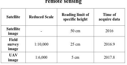
The application limit of satellite images and UAV images was summarized as shown in Table 1.
Table 1.Comparison to application limit for the
remote sensing
Satellite Reduced Scale Reading limit of specific height
Time of acquire data
Satellite
image - 50 cm 2016
Field survey image
1:10,000 25 cm 2016.9
UAV
image 1:6,000 5 cm 2017.8
The river environmental evaluation using the LAWA technique is carried out in the way to give points for 26 detailed physical parameters of planform, longitudinal profile, riverbed structure, cross-section, bank, structure and floodplain corridor according to the evaluator's subjective criteria. Table 2 shows the result of river environmental evaluation at the channel junction with the Han river using the LAWA technique. As a result of comparative analysis for the selected position, it was confirmed that the number of river environmental evaluation parameters that could be drawn through the satellite images and UAV images among the 26 parameters was 11 parameters and 23 parameters respectively.
Table 2. Result of river environmental
evaluation using the LAWA technique
3.2 Analysis result
The scores presented for each parameter according to the visual judgment were selected and evaluated. Sinuosity is classified into 5 levels according to the meandering level and this parameter evaluates the meandering level from the plan, and the longitudinal bars are the parameter evaluated according to the type and number of bars shown. The score of satellite images and UAV images evaluated according to the presented field book by subjective criteria is 27 points and 56 points respectively (Table 3).
w w w . i j m r e t . o r g I S S N : 2 4 5 6 - 5 6 2 8 Page 26
Table 3.Comparison whether or not to utilize
the remote sensing technique
Evaluation index Score
Amount Availability Sum Applicability
Satellite 11 0.4231 27 0.3803
UAV 23 0.8846 56 0.7887 Field
survey 24 0.9231 71 1.0000
The visual analysis result varies according to the photography technique or resolution, and this
result is significantly influenced by the
characteristics of target basin for river
investigation. The result of the Cheongmi stream which was a large urban stream and the applicability of remote sensing data acquired from the Namdae stream screen which was a small mountainous stream studied previously were summarized in Table 4. O for a parameter that could be utilized, △ for a parameter that could be utilized conditionally or partially and x for a parameter that could not be utilized were marked respectively. In case of satellite images, it was possible to confirm the riverbed protection, riverbank system and riparian buffer strip in an urban stream that were unavailable from a mountainous stream, and in case of UAV image, the status of 2 parameters of longitudinal profile were drawn additionally.
Table 4. Analysis of availability and applicability by parameter
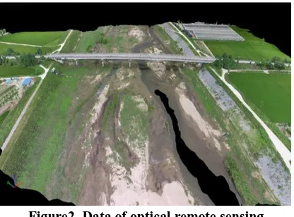
The produced data showed the overall accuracy within 15 cm although there was a difference by target area. The allowable limit of error for the coordinates of boundary point provided in the Act on the Establishment, Management, Etc. of Spatial Data is within 10 cm based on the target area, so it is judged that it is possible to acquire image data for river environmental evaluation using such images. Fig. 2 shows an data of the blue rice stream obtained using an optical remote sensing technique.
Figure2. Data of optical remote sensing techniques from Cheongmi stream
IV. CONCLUSION
w w w . i j m r e t . o r g I S S N : 2 4 5 6 - 5 6 2 8 Page 27
evaluation was carried out with the field research at the same time. Through this evaluation, the data acquisition range and application limit of each river environmental evaluation technique proposed previously were identified. As a result of comparison, it was found that various evaluation parameters could be drawn from UAV images enabling the acquisition of relatively higher precision images in comparison to satellite images. It is judged that remote sensing image data could be provided as a useful tool for monitoring and evaluating the environment of a river through the integration of GPS and GIS technologies.
V. Acknowledgements
This research was supported by a
grant(16AWMP-B121100-01) from the Water Management Research Program funded by Ministry of Land, Infrastructure and Transport of Korean government.
REFERENCES
[1] S.S. Ahn, Y.Y. Choi, and S.S. Lee, A study on effects of
hydraulic structure on river environment, J. of the
Environmental Sciences, 11(3), 2002, 191-199.
[2] S.H. Chun, S.G. Park, and S.K. Chae, Review of some
advanced stream environmental assessment systems, Journal of Korean society of hazard mitigation, 14(2), 2014, 355-362.
[3] G.H. Rosenfield, and K. Fitzpatirck-Lins, A coefficient
of agreement as a measure of thematic classification
accuracy, Photogramm. Eng. Remote Sens., 52(2), 1986,
223-227.
[4] C. Dietzel, M. Herodl, J.J. Hemphill, and K.C. Clarke,
Spatial-tem dynamics in California`s central
valley:empirical links to urban theory, Int. J. Geograph. Inf. Sci., 19, 2005, 175-195.
[5] Q. Lu, and D. Weng, Urban classification using full
spectral information of landsat ETM+ imagery in marion county, Indiana, Photogramm. Eng. Remote Sens., 71(11), 2005, 1275-1284.
[6] A. Butt, R. Shabbir, S.S. Ahmad, and N. Aziz, Land use
change mapping and analysis using remote sensing and GIS : A case study of simply watershed, Islamabad,
Pakistan. The Egyptian journal of remote sensing and
space science, 18(2), 2015, 251-259.
[7] M. Hussain, D. Chen, A. Cheng, H. Wei, and D. Stanley,
Change detection from remotely sensed images : From
pixel-based to object-based approaches. Journal of
Photogrammetry and Remote Sensing, 80, 2013, 91-106.
[8] D.R. Lyzenga, Passive remote-sensing techniques for
mapping water depth and bottom features, Applied Optics, 17, 1978, 379-383.
[9] W.D. Philpot, Bathymetric mapping with passive
multispectral imagery,Applied Optics, 28, 1989, 1569-1578.
[10] J.S. Rawat, and M. Kumar, Monitoring land use/cover
change using remote sensing and GIS technique:A case study of Hawalbagh block, district Almora, Uttarakhand,
India, The Egyptian journal of remote sensing and space
science, 18(1), 2015, 77-84.
Author Profile:
1. Yeo HongKoo, Research Fellow, Department of Land, Water and Environment Research, Korea
Institute of Civil Engineering and Building Technology, Republic of Korea
2. Kim Jong Tae, Research Director, Nature & Technology Inc., Republic of Korea
3. Kim Ji Hyun, Researcher, Department of Land, Water and Environment Research, Korea Institute of
Civil Engineering and Building Technology, Republic of Korea
Corresponding author: