Abstract—Intelligence multimedia map (IMM) is an electronic map, which includes multimedia of real location environment and an intelligent system for searching the best path. The objective of this research is to create computer software, including multimedia technology and artificial intelligent technique to increase usability and efficiency of an electronic map. A user just selects source and destination in the IMM. Then, the IMM will select the best path from source to destination, including multimedia display of real environment between source and destination location. This research was done in order to access the following qualities: 1) usability to prove that the system can search for all locations in Mahidol University at Salaya campus, and provide the best direction leading to the destination with the minimum cost, including time and cost of travelling 2) efficiency to present that the system can work with high accuracy.
Index Terms—Intelligence multimedia map, Best path selection, Smart navigation, Multimedia synchronization.
I. INTRODUCTION
Normally, a static map is spatial information on a paper-based drawing, which shows a lot of information e.g. road, building, bridge, water pool etc. (as shown in Fig 1). The static map uses different notations, symbols and colors to represent a lot of spatial information for users. Nevertheless, a static map cannot still serve endless human need. Nowadays, people use an electronic map instead of a static map for more convenience and more accuracy, and to get more information. The electronic map (also called a digital map, screen map or instantaneous map) is a visual map, which includes many new technologies e.g. geographic information system (GIS), multimedia, hypertext, virtual reality and data communication techniques, etc. A multimedia map is one type of electronic maps, which combine both spatial information and multimedia technology to help people to see the real environment with spatial information. The objective of this research is to build a multimedia map combined with a computer intelligent technique for searching the best path between source and destination for a user. The developed system is called “intelligent multimedia map (IMM)”. The related works, system designs, experimental results and conclusions will be presented in the next sections [1-3].
Manuscript received July 19, 2011, revised October 18, 2011.
Chomtip Pornpanomchai is an Assistant Professor in the Faculty of Information and Communication Technology, Mahidol University, Bangkok 10400, Thailand (e-mail: [email protected])
Hathaipath Lekpoolkerd, Anupap Piyaapinant, and Pornpen Panitpachdeekun are graduated from the Faculty of Information and Communication Technology, Mahidol University, Bangkok 10400, Thailand, (e-mail:{u5088066,u5088096,u5088180}@student.mahidol.ac.th)
Fig.1 The static map of Mahidol University@Salaya campus (Reference:http://grad.mahidol.ac.th/grad/event/map.html)
II. RELATED WORKS
Based on the research objective, the related works of the IMM system are emphasized in two research areas, which are multimedia of travel environment and locomotive selection. Each research area has the following brief details.
A. Multimedia of Travel Environment
Many researchers apply a multimedia map for helping users to see the travel environment. Xiehao Bao et al. (2009) developed a multimedia tourist guide on mobile phone equipment. Haomin Jin et al. (2000) and Yu Han (2001) developed a multimedia map database for identifying buildings and the real environment behind buildings. Jiang Lu and Xu Hongzhen (2010) implemented the virtual reality modeling language (VRML) in a 3-D electronic map for viewing the East China Institute of Technology campus. Yang Yang et al. (2009) applied the Google map to implementing the campus spatial information services of Xinjiang University [4-8].
B. Locomotive Selection
There are many researchers developing a multimedia map to help users to select a travel path. Some of them are the following. Feng Xu and Junping Du (2009) developed a voice navigator by using GIS on a mobile phone for tourists. Wen Wu et al. (2006) described the development of a multimedia map to navigate people for driving with trip planning and video-based guidance. Gamhewage C. de Silva and Kiyoharu Aizawa (2010) proposed a set of sketch-based interaction techniques for interacting with a location-based multimedia system. Oliver Pink (2008) presented a technique
Intelligence Multimedia Map
Chomtip Pornpanomchai, Member, IACSIT, Hathaipath Lekpoolkerd, Anupap Piyaapinant, and
to support environment perception and path planning of mobile robots by using a global feature map [9-12].
III. METHODOLOGY
In this section, the part of system analysis and design are focused on. The section provides more understanding of how each component and fuction in the IMM system work.
A.System Conceptual Diagram
There are three main components in the system conceptual diagram (as shown in Fig. 2), namely: configuration tool, system database and graphic user interface (GUI). Each component has the following details.
Fig. 2 The IMM System conceptual diagram
1)Configuration tool
The configuration tool is a component, which is available for system’s administrator to manipulate a physical map, a virtual map, paths and buildings. All changing data are saved into the IMM system database.
2)System database
The system database component is a computer data storage, which stores all the IMM system information. The main parts of the IMM system information are the physical or static map, the visual map, video clip of the campus real environment and all possible paths for travelling in the campus. Moreover, the IMM system receives both source and destination locations from a user and calculates the best path from all possible paths in the system database.
3)Graphic user interface (GUI)
The graphic user interface (GUI) is a user tool for viewing a multimedia map with the direction in the visual map. Moreover, this component works together with the IMM best path calculation to provide the best path selection for a user.
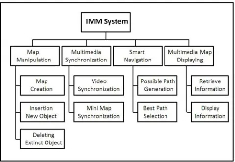
B.System Structure Chart
Based on the system conceptual diagram in the previous section, the mapping between the system conceptual diagram and the system structure chart is presented in this section. There are four main modules in the system structure chart, namely: a map manipulation module, a multimedia synchronization module, a smart navigation module, and a
map display module (as shown in Fig. 3). Each module has the following details.
1)Map manipulation module
This module is used for modifying both static and visual maps e.g. draw a new building, draw a new road, erase an extinct path, erase an extinct building, etc. This module consists of three sub-modules, which have the following details.
a) Map creation sub-module
This sub-module creates new static and visual maps. After creating all the maps, the system stores all new created maps into a system database.
b) Insert new object sub-module
This sub-module inserts a new object into the system maps including object attributes e.g. name, dimension, location, etc. The system uses the record locking technique to avoid new object insertion errors.
c) Delete extinct object sub-module
This sub-module deletes an extinct object from the system database e.g. an extinct building, extinct road, extinct path way, etc.
Fig. 3 System structure chart of IMM system
2)Multimedia synchronization module
This module connects a multimedia system including text, video and maps. The multimedia synchronization consists of two sub-modules, which are video synchronization and mini-map synchronization. Each sub-module has the following details.
a) Video synchronization sub-module
There are three video views display for users between locomotive. The three video views are the front view, the left-side view and the right-side view of the real environment. The IMM system needs to synchronize the three video views for users for more convenience and more understanding.
b) Mini-map synchronization sub-module
mini-map and all multimedia files to see more details in the video scene.
3)Smart navigation module
This module provides an intelligent searching and distance calculation functions for selecting the best path. The smart navigation module is embedded in the IMM system and it is divided into two sub-modules, which are all possible paths generation and the best path selection. Each sub-module has the following details.
Fig. 4.The IMM location selection screen
a)All possible paths generation
A user selects a source and a destination location (as shown in Fig 4) by observing all locations in a static map (label number 1). Then the user uses drop-down menu to select source and destination locations (labels number 2 and 3, respectively). Finally, the source and destination locations are described for all details in description boxes (labels as number 4 and 5, respectively). The user can select the display multimedia map by clicking on the show direction button (label number 6).
b)The best path selection sub-module
The best path selection sub-module selects all the paths from source to destination locations. Then this sub-module applies the branch and bound searching algorithm to select the best path by using both cost and time criteria. After the system selects the best path, it will display the best path in the mini-map on the GUI for a user navigator.
4)Multimedia map display module
After the smart navigating processes are done, the next process is to display all information to a user. The multimedia map display module consists of two sub-modules, which are retrieve information and display information. Each sub-module has the following details.
a)Information retrieval sub-module
This sub-module retrieves all necessary information from the system database e.g. multimedia files, mini-map, best path selection, etc. Then the system sends all information to the display information sub-module.
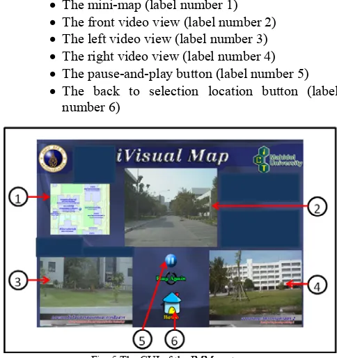
b)Information displaying sub-module
This sub-module displays all retrieved information on the system GUI (as shown in Fig. 5). The system GUI has the following details.
• The mini-map (label number 1) • The front video view (label number 2) • The left video view (label number 3) • The right video view (label number 4) • The pause-and-play button (label number 5) • The back to selection location button (label
number 6)
Fig. 5.The GUI of the IMM system
IV. TESTING AND EVALUATION
This section presents experimentation on the IMM system, which is developed depending on the concepts and the design mentioned in the previous section. The experiments were mainly focused on the usability and the effectiveness of the system. The usability testing proves whether the system was capable of performing the proposed functions as mentioned earlier. The effectiveness and reliability test determined the correctness of the system and whether the system results could be used in the real life.
A.Usability Test
For usability testing, the system tests all required functions to prove that all functions can work well. The required functions consist of the contents that are explained as the following:
• The application can open and do the search direction function.
• The application can show the direction of all exist paths in the system.
• The functions of the mini-map display and work completely depending on its virtual map.
• The IMM searches direction and displays the result smoothly without any error.
B.Effectiveness and Reliability Test
TABLE I: EFFECTIVENESS AND RELIABILITY TEST RESULT
Source Destination Number of Video files Processing time (Sec.) Result Office of the President Fact. of Physical Therapy 8 1.98 Pass Fact. of Science International College 4 2.13 Pass International Collage Fact. of ICT 8 2.08 Pass Cafeteria Fact. of Engineering 10 1.79 Pass Fact. of ICT ASEAN Inst. for Health. 13 1.76 Pass School of Nursing Badminton Building 6 1.66 Pass College of Music Library Building 18 1.81 Pass Gate 4 Fact. of Veterinary 9 1.90 Pass Fact. of Science College of Music 6 1.65 Pass Thai Herb Garden Institute of Nutrition 14 2.01 Pass Gate 4 Fact. of Liberal Arts 6 1.97 Pass Gate 3 College of Music 10 1.92 Pass Gate 3 Fact. of Veterinary 11 1.78 Pass Fact. of ICT Cafeteria 7 1.97 Pass
Condominiums Library Building 12 2.08 Pass
National Animal Center Inst. of Molecular Bio. 11 1.92 Pass Fact. of Veterinary Parking Lot 2 5 1.96 Pass Gate 6 Fact. of Environment 14 1.92 Pass Parking Lot 2 Fact. of Engineering 8 1.96 Pass
Based on the result of all experiments that the system has done for the IMM system testing, we can conclude that the system is very usable, reliable and effective in direction searching and direction leading for the area around Mahidol University at Salaya campus. All required functions work very well and can fulfill the objective of this project.
V. CONCLUSIONS
From the discussion in the previous section, the IMM system strongly concentrates on its usability and effectiveness. It is not only used as a tool to eliminate the difficulties of using a static map for user’s convenience but can also provide other benefits which are explained as the following.
• As the application provides an easy way to use interface design, users can search for their places easily more and the results of all information are presented in a multimedia format, which can better help users to interpret the map’s direction.
• Users can use the IMM Application as a smart tool for helping them to quickly find the correct and best direction leading to the destination, which enable the users to save their time and cost of travelling.
• As the video synchronization provides the real environment around the campus. The users, in their capacity as construction employees, can also use the application for observation and maintenance planning.
REFERENCES
[1] Mahidol University, Salaya campus map, In http://grad.mahidol.ac.th/grad/event/map.html, Access on June 2011. [2] Cai Zhonglian, Wu Guofeng, Weng Min and Du Qiangyun, The
Organization of Multimedia Information in Electronic Map,
Geo-spatial Information Science (Quarterly), 2002, Vol. 5, Issue 2, PP 56-61.
[3] Zhiqing Zhu, Fuliang Li and Jieli Sun, Research on Digital-Monitor-Oriented Electronic Map, In Proceeding of Asia-Pacific Conference on Computational Intelligence and Industrial Applications, 28-29 Nov 2009, Wuhan, Hubei, China, PP 134-137. [4] Xiehao Bao, Hongxia Bie and Mingxiao Wang, Interation of
Multimedia and Location-Based Services on Mobile Phone Tour Guide System, In Proceeding of International Conference of Network Infrastructure and Digital Content, 6-8 Nov 2009, Beijing, China, PP 642-646.
[5] Haomin Jin, Xu Xu, Yaginuma Yoshitomo and Masao Sakauchi, A System of Integrating Videos and Maps for the Identification of Building Object, In Proceeding of International Conference on Multimedia and Expo, 30 Jul 2000 - 02 Aug 2000, New York, USA, PP 735-738.
[6] Yu Han, Haomin Jin and Masao Sakauchi, Construction of Multimedia Map Database Using Urban City Image, In Proceeding of International Conference on Multimedia and Expo, 22-25 Aug. 2001, Tokyo, Japan, PP. 325-328.
[7] Jiang Lu and Xu Hongzhen, VRML-Based Three-Dimensional Electronic Map System on Campus, In Proceeding on International Conference on Multimedia Technology, 29-31 Oct 2010, Ningbo, China, PP1-3.
[8] Yang Yang, Jianhua Xu, Jianghua Zheng and Shouy Lin, Design and Implementation of Campus Spatial Information Service Based on Google Maps, In Proceeding of International Conference on Management and Service Science, 20-22 Sep 2009, Wuhan, Hubei, China, PP.1-4.
[9] Feng Xu and Junping Du, Main Algorithms Study and Implementation of Tourist Spot Navigation System, In Proceeding of International Conference on Computational Intelligence and Software Engineering, 11-13 December 2009, Wuhan, Hubei, China, PP. 1-5.
[10] Wen Wu, Jie Yang and Jing Zhang, A Multimedia System for Route Sharing and Video-Based Navigation, In Proceeding of International Conference on Multimedia and Expo, 9-12 Jul 2006, Toronto, Canada, PP.73-76.
[11] Gamhewage C. de Silva and Kiyoharu Aizawa, Interacting with Location-based Multimedia using Sketches, In Proceeding of international Conference on Image and Video Retrieval, 5-7 Jul 2010, Xi’an China, PP. 189-196.
Chomtip Pornpanomchai received his B.S. in general science from Kasetsart University, M.S. in computer science from Chulalongkorn University and Ph.D. in computer science from Asian Institute of Technology. He is currently an assistant professor in the Faculty of Information and Communication Technology, Mahidol University, Bangkok, Thailand. His research interests include artificial intelligence, pattern recognition and object-oriented systems.
Hathaipath Lekpoolkerd was born in Bangkok,
Thailand. She received her B.S. in Information and Communication Technology, Mahidol University, Bangkok, Thailand.
Anupap Piyaapinant was born in Bangkok, Thailand.
He received his B.S. in Information and Communication Technology, Mahidol University, Bangkok, Thailand.
Pornpen Panitpachdeekun was born in Bangkok,