Insert document title
Location | Date
ATSB Transport Safety Report
[Insert Mode] Occurrence Investigation
XX-YYYY-####
Final
Investigation
conditions and loss of control
involving Piper PA-28-180,
VH-POJ
Investigation
31 km north of Horsham Airport, Victoria | 15 August 2011
ATSB Transport Safety Report
Aviation Occurrence Investigation
AO-2011-100
Released in accordance with section 25 of the Transport Safety Investigation Act 2003
Publishing information
Published by: Australian Transport Safety Bureau Postal address: PO Box 967, Civic Square ACT 2608
Office: 62 Northbourne Avenue Canberra, Australian Capital Territory 2601 Telephone: 1800 020 616, from overseas +61 2 6257 4150 (24 hours)
Accident and incident notification: 1800 011 034 (24 hours) Facsimile: 02 6247 3117, from overseas +61 2 6247 3117
Email: [email protected] Internet: www.atsb.gov.au
© Commonwealth of Australia 2013
Ownership of intellectual property rights in this publication
Unless otherwise noted, copyright (and any other intellectual property rights, if any) in this publication is owned by the Commonwealth of Australia.
Creative Commons licence
With the exception of the Coat of Arms, ATSB logo, and photos and graphics in which a third party holds copyright, this publication is licensed under a Creative Commons Attribution 3.0 Australia licence.
Creative Commons Attribution 3.0 Australia Licence is a standard form license agreement that allows you to copy, distribute, transmit and adapt this publication provided that you attribute the work.
The ATSB’s preference is that you attribute this publication (and any material sourced from it) using the
following wording: Source: Australian Transport Safety Bureau
Copyright in material obtained from other agencies, private individuals or organisations, belongs to those agencies, individuals or organisations. Where you want to use their material you will need to contact them directly.
What happened
On 15 August 2011, the pilot of a Piper
PA-28-180 Cherokee aircraft, registered VH-POJ, was conducting a private flight transporting two passengers from Essendon to Nhill, Victoria under the visual flight rules (VFR). The flight was arranged by the charity Angel Flight to return the passengers to their home location after medical treatment in Melbourne. Global Positioning System data recovered from the aircraft indicated that when about 52 km from Nhill, the aircraft conducted a series of manoeuvres
followed by a descending right turn. The aircraft subsequently impacted the ground at 1820 Eastern Standard Time, fatally injuring the pilot and one of the passengers. The second passenger later died in hospital as a result of complications from injuries sustained in the accident.
What the ATSB found
The ATSB found that the pilot landed at Bendigo and accessed a weather forecast before continuing towards Nhill. After recommencing the flight, the pilot probably encountered reduced visibility conditions approaching Nhill due to low cloud, rain and diminishing daylight, leading to disorientation, loss of control and impact with terrain. One of the passengers was probably not wearing a seatbelt at the time of the accident.
The ATSB also established that flights are permitted under the visual flight rules at night (night VFR) in conditions where there are no external visual cues for pilots. In addition, pilots conducting such operations are not required to maintain or periodically demonstrate their ability to maintain aircraft control with reference solely to flight instruments.
What's been done as a result
As a result of previous ATSB investigations the Civil Aviation Safety Authority (CASA) has drafted new legislation, effective 4 December 2013, requiring a biennial review for night VFR-rated pilots. In addition, CASA has indicated that it will clarify the nature of what is meant by the term ‘visibility’ in dark night conditions, provide enhanced guidance on night VFR flight planning, and provide enhanced guidance on other aspects of night VFR operations. The ATSB issued a safety recommendation as a result of investigation AO-2011-102 for CASA to prioritise this initiative. The ATSB is also producing an educational booklet in its Avoidable Accident Series related to visual flight at night. When released, this safety education booklet will highlight a number of the risks associated with night VFR flight and discuss strategies for their management.
Safety message
All operators and pilots considering night VFR flights should assess the likelihood of dark night conditions by reviewing the weather conditions, celestial illumination and available terrain lighting affecting their planned flight. A VFR flight in dark night conditions should only be conducted by a pilot with high instrument flying proficiency as there is a significant risk of losing control if
attempting to fly visually in such conditions. Application by pilots of the recommendations in CASA advisory publication CAAP 5.13-2(0) will reduce the risks associated with visual flight at night. Additionally, wearing seatbelts will reduce the likelihood and severity of injuries in an aircraft accident.
VH-POJ
Contents
The occurrence ...1 Context ...5 Personnel information 5 Aircraft information 5 General 5Weight and balance 6
Operational information 6
Weather 6
Last light 7
Wreckage and impact information 7
Medical and pathological information 8 Organisational and management information 9
Angel Flight 9
North American Angel Flight 10
Tests and research 10
Flight under the night VFR 11
Last light 11
Weather 12
Lowest safe altitude 12
Civil Aviation Safety Regulation Part 61 12
Related occurrences 13
Australian occurrences 13
United States occurrences 15
Safety analysis ... 17
Introduction 17
Flight planning considerations 17
Development of the accident 18
Spatial disorientation 18
Managing reduced night visual cues 19
Pilot decision making 19
Survivability 19
Minimum requirements for night flights 20 Other efforts to reduce the risk of night operations 21
Findings ... 22
Contributing factors 22
Other factors that increase risk 22
Other finding 22
Safety issues and actions ... 23
Requirements for visual flight rules flights in dark night conditions 23
Safety issue description: 23
General details ... 25
Occurrence details 25
Aircraft details 25
Sources and submissions ... 26
Sources of information 26
References 26
Appendix A ... 27
Accidents involving night VFR operations 27
Australian Transport Safety Bureau ... 29
Purpose of safety investigations 29
The occurrence
On 15 August 2011, the pilot of a Piper PA-28-180 Cherokee aircraft, registered VH-POJ (POJ), was conducting a private flight transporting two passengers from Essendon to Nhill, Victoria (Vic.) under the visual flight rules (VFR)1. Global Positioning System (GPS)2 data recovered from the aircraft indicated that near the locality of Wallup, about 52 km from Nhill, the aircraft conducted a series of manoeuvres before impacting the ground at 1820 Eastern Standard Time3, fatally injuring the pilot and one passenger. The second passenger later died in hospital as a result of complications from injuries sustained in the accident. The aircraft was destroyed in the accident. The pilot departed Yarrawonga, Vic. at 0807 that morning for Albury, New South Wales. At Albury, he refuelled the aircraft, picked up two passengers and flew to Essendon, arriving at 1035. That flight, and the subsequent flight to Nhill, were both arranged by the charity Angel Flight to facilitate the passengers’ access to medical services in Melbourne, Vic.
The pilot fully refuelled the aircraft at Essendon, which provided an endurance of about 4.5 hours. That endurance was more than was needed to complete the planned flight to Nhill with required reserves and permitted in-flight diversions or holding if required. After refuelling the aircraft the pilot waited for one of the next two planned passengers4 to complete their medical appointments before commencing the flight to take them home to Nhill at about 1600.
The Bureau of Meteorology advised the ATSB that at the time a cold front was moving across the west of Victoria. Cloud and patchy rain associated with the frontal system was affecting the southern and western parts of the state. A witness at Essendon Airport reported that the pilot expressed apprehension about the weather conditions.
Shortly before POJ departed Essendon, the two passengers and an accompanying Angel Flight volunteer boarded the aircraft with the pilot. One of the passengers, a 15 year-old girl, was reported to have been extremely nervous about the flight. This may have been due to her experience flying to Essendon from Nhill in turbulent weather earlier that day. The volunteer recalled a discussion with the pilot about the passenger’s nervousness, during which the pilot said that he intended to track further north to avoid inclement weather during the flight to Nhill. Before departure, the volunteer decided not to travel on the flight, so as to make the aircraft lighter and also avoid the need for the pilot to return the volunteer to Essendon prior to returning to his home in Yarrawonga. The volunteer further recalled that the other adult passenger was focussed on returning to Nhill due to family commitments and had not made alternative arrangements in the event the flight was not completed as planned.
The aircraft departed Essendon at about 1600, which was approximately 1 hour later than the intended departure time. The pilot had initially planned to fly to the VFR waypoints Kalkallo (KAO) and Kilmore (KIM), then direct to Nhill (Figure 1). Given the forecast winds and aircraft
performance, that route would have resulted in the aircraft arriving at Nhill at about 1753.
However, after passing KIM the aircraft was flown to Bendigo Airport, Vic. landing there at 1649.
1 Visual flight rules (VFR) are a set of regulations which allow a pilot to only operate an aircraft in weather conditions
generally clear enough to allow the pilot to see where the aircraft is going.
2 The Global Positioning System (GPS) is a space-based global navigation satellite system (GNSS) that provides
location and time information in all weather, anywhere on or near the Earth, where there is an unobstructed line of sight to four or more GPS satellites.
3 Eastern Standard Time (EST) was Coordinated Universal Time (UTC) + 10 hours.
4 There were two separate groups of passengers: one group travelling from Albury to Melbourne and one group travelling
Figure 1: VH-POJ track in yellow and planned track from KIM in red
Source: Google Earth image modified by the ATSB using recovered GPS data
While on the ground at Bendigo, the pilot logged on to the National Aeronautical Information Processing System (NAIPS)5 and accessed the latest Area 30 aviation weather forecast6 and associated reports for the remainder of the flight (Figure 2 - the weather affecting the flight is discussed more fully at the section titled Operational Information). It was reported that, while on the ground, a passenger telephoned a family member in Nhill and advised they might have to stay in Bendigo, indicating the pilot may have considered terminating the flight due to the weather conditions. During that telephone call the passenger reportedly received a favourable assessment of the local weather at Nhill.
Figure 2: Area 30
Source: Google Earth image modified by the ATSB
5 NAIPS can be accessed to provide briefings and flight notification functions.
6 Area forecasts are issued for the purposes of providing aviation weather forecasts to pilots. Australia is subdivided into
Information from a tablet computer that was recovered from the accident site showed POJ departed Bendigo for Nhill at 1711 (Figure 1). At 1748, the aircraft flew approximately 1 km south of Cope Cope. A witness at that location later reported an aircraft flying low with the engine sounding normal and that it had been raining, although not heavily. At about 1801, POJ passed to the west of Boolite, and a witness at that location reported hearing an aircraft that was described as flying low from the south-east to the north-west. That witness reported that it had been raining and had been ‘a terrible day’.
Two witnesses, who were located about 2 km south of the accident site (Figure 3), reported observing the aircraft circle their position before descending and disappearing from view behind trees as it flew to the north. Moments later they heard a loud bang that they associated with the aircraft impacting the ground. The witnesses indicated that there was light rain at the time and that the aircraft’s engine sounded ‘normal’ before the accident.
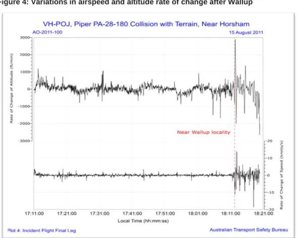
Recovered GPS data from the tablet computer showed that just before arriving in the vicinity of Wallup, the pilot initiated a series of manoeuvres before turning towards the south for about 7 km and then resuming a westerly track for about 5 km (Figure 3). The aircraft’s track changed abruptly after Wallup, with variations in altitude, heading and speed that were not apparent during the earlier part of the flight (Figure 4).
Figure 3: Aircraft’s track near Wallup
Figure 4: Variations in airspeed and altitude rate of change after Wallup
Source: ATSB
The recorded data from the tablet computer showed that at 1817 a 360° left turn was initiated, followed by a descending right turn. The aircraft impacted the ground about 31 km north of Horsham Airport, Vic. at 1820, 23 minutes after sunset and about 4 minutes before published last light7.
Following the impact, the witnesses to the south of the accident site immediately telephoned Horsham Airport to alert emergency services; however, they were unsure of the aircraft’s location. The aircraft’s emergency locator transmitter (ELT) did not activate during the impact sequence and the pilot was not heard to make any distress call.
Based on the witness reports of an aircraft accident in the locality, a search was commenced by Victoria Police and the aircraft was located at around 2030. Shortly after, medical personnel arrived at the site and confirmed that the pilot and one of the passengers had been fatally injured. The surviving passenger was airlifted to hospital later that evening.
The pilot had submitted a flight plan to Air Traffic Services (ATS) for the flight from Essendon to Nhill that nominated SARTIME8 of 2000 for arrival at Nhill. Examination of the pilot’s telephone records identified that, following expiry of the SARTIME, attempts were made by ATS to contact the pilot at 2008 and again at 2015.
7 Last light data was derived from Geoscience Australia’s web site (www.ga.gov.au) and was also available to the pilot
via NAIPS.
8 Time nominated by a pilot for the initiation of Search and Rescue action if a report from the pilot has not been received
Context
Personnel information
The pilot was issued with a Student Pilot (Aeroplane) Licence in December 1967 and, in
September 1968, gained a Restricted Private Pilot (Aeroplane) Licence. His logbook indicated that he had accumulated a total of 41 flying hours during 1968 and 1969 with no further flying being recorded until 1993. The pilot was issued with a Private Pilot (Aeroplane) Licence in
November 1993. At the time of the accident, the pilot had a total aeronautical experience of about 940 hours and held a valid Class 2 Aviation Medical Certificate with a requirement to wear distance vision correction and to have reading vision correction available. The pilot held the appropriate aircraft endorsement to operate POJ.
In 1994, the pilot was issued with a night VFR rating.9 The pilot’s night VFR experience consisted of 40.5 hours up to 1998 and a further 13.5 hours over the following 13 years. At the time of the accident, he had accumulated a total of 54 hours of night flying, of which 2.9 hours were in POJ. The night flying conducted by the pilot in POJ consisted of a flight with an instructor of 1.4 hours duration that was indicated in the pilot’s logbook as ‘Night VFR activation’ and a flight as pilot in command (PIC) of 1.5 hours duration on 14 June 2011, which was the pilot’s only night flight in the 90 days prior to the accident. From the evidence available, the ATSB was unable to confirm whether the pilot had performed the required three take-offs and landings during that flight to permit the carriage of passengers under the night VFR.10
Civil Aviation Advisory Publication (CAAP) 5.13-2(0) Night Visual Flight Rules Rating advised that night VFR pilots maintain their instrument flying skills by:
• keeping in current night flying practice and flying the aircraft with reference to instruments at all times when flying at night; or
• practicing their instrument flying skills under simulated conditions with a flight instructor; or • practicing instrument flying in a suitable synthetic flight trainer.
The pilot’s logbook recorded a total of 7.9 hours of instrument flight time by the pilot, the latest of which was 0.2 hours on 5 May 1996 during an aeroplane flight review. Additionally, 3 hours of ground instrument time was recorded in a synthetic training device in August and
September 2000. It could not be determined if the pilot practiced any instrument flying on
subsequent night flights; however, based on the pilot’s logbook, the opportunity to do so was less than 1 hour per year.
Aircraft information
General
The aircraft’s maintenance release was issued in the night VFR category and the aircraft was equipped for night VFR flight. There was no indication in the aircraft’s documentation of any unserviceable equipment or defects at the time of the accident. The aircraft’s maintenance release was issued on 5 November 2010 for 12 months or 100 hours flight time, which ever occurred first. The aircraft had flown for approximately 9 hours beyond the maintenance release flight time expiry.
The aircraft was fitted with a 121.5/243 MHz emergency locator transmitter (ELT). That ELT did not satisfy the requirements of Civil Aviation Regulation (CAR) 252A requiring the installation of a 406 MHz ELT. CAR 252A could have been satisfied by the carriage of a suitable portable locator beacon (PLB) and the pilot’s flight plan stated that a PLB was carried on the aircraft. However, no
9 The Night VFR rating allows the holder to fly an aircraft by night under the visual flight rules. 10 Civil Aviation Regulation 5.82 Private (aeroplane) pilot: recent experience requirements.
PLB was found in the aircraft wreckage or at the accident site by either the ATSB or the Victorian Police.
The ELT was not triggered by impact forces, although its associated g-switch activated when tested by the ATSB. In that context, a 406 MHz ELT, if installed, may not have triggered during the impact sequence.
Weight and balance
The passengers’ seating positions on departure from Essendon could not be confirmed, but it was likely that both were in the rear seats, which was their reported position when the Angel Flight volunteer left the aircraft. Considering the probable loading of the occupants and fuel, the aircraft’s centre of gravity (CG) would have been within the manufacturer’s permitted range when departing Essendon. Given the aircraft’s estimated fuel load when it left Bendigo, the CG would have been within limits under all possible passenger seating configurations.
Operational information
Weather
The Bureau of Meteorology (BoM) forecast reflected a relatively complex weather situation affecting the intended flight from Bendigo to Nhill. The forecast indicated Broken11 cloud from 3,000 to 8,000 ft above mean sea level (AMSL),12 Broken cloud from 800 to 2,000 ft in rain over the northern slopes of the Great Dividing Range13 and Scattered cloud from 1,000 to 2,500 ft in precipitation elsewhere. The BoM confirmed that the track from Bendigo to Nhill passed through the northern slopes area. The terrain elevation along the intended track varied between about 500 ft and 1,700 ft. Visibility was forecast to reduce to 5,000 m in rain.
The area forecasts issued by BoM included a contact telephone number to enable pilots to speak with meteorologists and gain assistance with interpreting and understanding the weather
conditions that were likely to be encountered. Telephone records for the pilot’s mobile phone indicated that he did not call the BoM number to discuss the area forecast; however, he did call a number which provided automated weather information for the Kilmore area.
The aerodrome forecast for Nhill was valid until 1800 and predicted Few cloud at 2,000 ft and Scattered cloud at 3,500 ft with intermittent deterioration to Broken cloud at 1,000 ft with rain. As there was no aerodrome forecast available for Nhill after 1800 the pilot was required to make provision for a diversion to an alternate airport.
A BoM aftercast of the likely weather conditions in the area at the time of the accident estimated Scattered to Broken cloud bases between 2,000 and 4,000 ft with the possibility of lower patches. In addition, moderate turbulence was likely below 7,000 ft between Bendigo and Nhill.
Witnesses who observed the aircraft shortly before impact indicated that it was raining at the time. A pilot flying under the instrument flight rules (IFR)14 between Wangaratta and Horsham via Warracknabeal, Vic. reported the cloud cover increased when approaching Warracknabeal. On
11 Cloud cover is normally reported using expressions that denote the extent of the cover. The expression Few indicates
that up to a quarter of the sky was covered, Scattered indicates that cloud was covering between a quarter and a half of the sky. Broken indicates that more than half to almost all the sky was covered, while Overcast means all the sky was covered.
12 Unless indicated otherwise, heights are above average sea level.
13 The Northern Slopes are not shown on any maps however they refer to the area where a prevailing northerly wind rises
due to terrain associated with the Great Dividing Range.
14 Instrument flight rules permit an aircraft to operate in instrument meteorological conditions (IMC), which have much
lower weather minimums than visual flight rules. Procedures and training are significantly more complex as a pilot must demonstrate competency in IMC conditions, while controlling the aircraft solely by reference to instruments.
arrival at Horsham at 1756, the pilot was required to conduct a low-level circuit due to the presence of low cloud and rain.
Another pilot who arrived at Horsham from the north-east was also flying under the IFR and landed between 1835 and 1840. This pilot reported that he was still in cloud at 2,200 ft on descent and that the cloud base was between 500 and 800 ft above ground level (AGL).
The temperature and dewpoint15 in the area at the time of the accident were conducive to carburettor icing. However, the recorded data, in particular the aircraft’s ground speed, and witness statements indicating that the engine was performing normally before the accident, suggests that carburettor icing was not a factor.
Last light
Last light at Nhill on the day of the accident was 182516. With regard to the determination of last light, paragraph 1.2 of GEN 2.7 SUNRISE/SUNSET TABLES of the Aeronautical Information Publication Australia (AIP) stated:
…the parameters used in compiling daylight and darkness graphs do not include the nature of the terrain surrounding a location, or the presence of other than a cloudless sky and unlimited visibility at that location. Consequently, the presence of cloud cover, poor visibility or high terrain to the west of an aerodrome will cause daylight to end earlier than that extracted from the appropriate graph. Allowance should be made for these factors when planning a flight having an estimated time of arrival (ETA) near the end of daylight.
On the night of the accident, moon illumination was 98 per cent17, but moonrise did not occur until 1930 so the moon would not have provided any illumination benefit before then. In addition, there was only limited ground lighting on the track between Bendigo and Nhill, which would have provided few visual cues to the pilot.
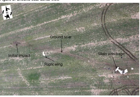
Wreckage and impact information
The aircraft impacted the ground at about 200 km/hr (about 108 kts) and skidded along the ground for about 100 m before coming to rest (Figure 5). Ground scars and evidence from the wreckage were consistent with the aircraft impacting the ground in a descending right turn, with the right wingtip impacting the ground first. Soil in the vicinity of the right wing was contaminated with fuel.
15 Dewpoint is the temperature at which water vapour in the air starts to condense as the air cools. It is used among other
things to monitor the risk of aircraft carburettor icing or likelihood of fog at an aerodrome.
16 Last light was computed using the National Aeronautical Information Processing System. 17 Moonrise and illumination were accessed from the Geoscience Australia website www.ga.gov.au
Figure 5: Ground scar aerial view
Source: ATSB
All of the aircraft’s primary structure and flight controls were located at the accident site and there was no evidence of fire or pre-impact failure. No anomalies with the aircraft’s flight control system were identified. The flap actuator handle was found in the retracted position and there was no damage indicating that the handle had been forced into the retracted position during the impact sequence. The pattern of earth on the upper wing surface was also consistent with the flaps being in the retracted position during the impact sequence. Landing light filament stretch was consistent with it being on at impact.
Three of the aircraft’s four seatbelts were found fastened, but two of them had failed due to overstress. Examination of the unfastened, right-rear seatbelt identified that it had not been fastened during the impact. Damage to the aircraft and the location of the occupants at the accident site suggested that the passenger in the right rear position was unrestrained at impact. The engine and a number of other components, including the aircraft’s attitude and airspeed indicators, were recovered from the accident site and transported to the ATSB’s technical facilities in Canberra for technical examination. That examination found no signs of pre-impact damage or failure to any of the items or components. However, score marks made by the rotating gyro rotor on the inside of the attitude indictor’s casing indicated that the gyro was rotating at impact.
Witness marks on the face of the airspeed indicator were consistent with the GPS-recorded speed of 200 km/hr at impact.
Medical and pathological information
The pilot’s post-mortem examination found no underlying medical disorder likely to lead to incapacitation and there was nothing contributory found in the toxicology analysis. Evidence consistent with the pilot having worn the installed seatbelt at the time of the accident was identified by the pathologist.
Post-mortem examination of the passenger who was fatally injured at the accident site found no evidence that she had been restrained by a seatbelt at the time of impact. The pathologist advised that, given the often complex forces associated with aircraft accidents, use of a seatbelt was not always evident. Post-mortem examination did not identify any evidence that the second passenger was wearing a seatbelt at the time of the accident. That may have been due to the time that had elapsed since the accident.
Organisational and management information
Angel Flight
Angel Flight is a charity, which commenced in Australia in April 2003 and assists people to access medical services. The Angel Flight website described their operation as follows:
Angel Flight Australia is a charity that co-ordinates non-emergency flights for financially and medically needy people. All flights are free and assist patients or compassionate carers travelling to or from medical facilities anywhere in Australia. Angel Flight pilots do not carry aero medical staff or medical equipment so do not act as an alternative to the Flying Doctor (RFDS) or Air Ambulance in that capacity. Angel Flight services are entirely free.
Due to potential similarities with operations that were conducted as charter and aerial work, the ATSB sought clarification from CASA regarding the operational category for Angel Flight operations.
CASA advised that, consistent with Aviation Ruling 3/200318Application of CAR 206 to operations conducted for the benefit of a charitable entity, Angel Flight passenger transfer operations were classified as private flights. As a result, operational responsibility for the flights rested with the PIC. This was consistent with advice from Angel Flight that it was not an Air Operator Certificate holder, nor an operator.
Prospective users of Angel Flights were informed that the type of flight being undertaken was not a charter or ambulance flight. Additionally, upon registering, patients were required to sign a form which, in part, stated:
In the event of inclement weather, lack of pilots or other complications, Angel Flight will use its best endeavours to make alternative transport arrangements. However, please be mindful that you may have to make your own alternate travel arrangements.
As at June 2013, Angel Flight had coordinated about 14,800 ‘missions’ and had 2,600 pilots registered for consideration to conduct such flights of which 587 pilots had actually flown missions. Demographic information provided by Angel Flight identified that the average PIC hours was about 2,400 with 64 per cent of pilots holding an instrument rating and 16 per cent holding a night VFR rating. About 61 per cent of pilots held a private pilot licence with the remainder holding at least a commercial pilot licence.
Information provided to the ATSB by Angel Flight identified that they were aware of one previous accident that occurred during a mission coordinated by Angel Flight prior to the accident involving POJ, and one accident and two incidents that occurred afterwards. In response to two of these occurrences, Angel Flight requested the pilots to provide further information and documentation in relation to the occurrences and, in one case, suggested that the pilot undergo remedial training and provide evidence of its completion prior to undertaking further missions.
Pilot and aircraft requirements
Angel Flight advised that they relied upon the CASA-regulated training, testing, and licensing requirements for private pilots. Angel Flight also required pilots to hold a minimum of 250 hours as PIC. At the time of joining as a volunteer, pilots were required to complete an affirmation that stated they would comply with these requirements and that the aircraft used had a valid airworthiness certificate and maintenance release and carried all required documentation. When applying for a mission, pilots were required to confirm that they were current for their planned type of flight, for example, a flight under the night VFR or IFR. The pilot of POJ met these requirements at the time of applying. However, the ATSB was unable to determine whether he met the recency requirements to enable him to carry passengers on the night of the accident (see previous discussion titled Personnel information).
Flight planning requirements
Angel Flight documented guidance for pilots stated that the PIC was solely responsible for operational decision making. Pilots were made aware that if a mission could not be completed alternate provisions would be made for the passengers, and that pilots should not feel pressured to complete a mission.
Angel Flight also recommended that pilots lodge flight plans and required that, at a minimum, a flight note was left with a responsible person.
North American Angel Flight
There were ten organisations in North America (US and Canada) who organised charitable medical flights and used the Angel Flight name (including one with the title Mercy Flight, which had started as Angel Flight). Each organisation was administered separately and operated within different geographical areas. The pilot requirements and operational considerations for each organisation differed somewhat, however each organisation specified a minimum number of hours a pilot had to have before they could join as a volunteer.
All of the ten organisations required pilots to hold a current licence and medical and to be
endorsed for the aircraft they flew. The minimum total flying hours (including time as PIC) required on entry as a volunteer ranged from 250 hours to 500 hours. Some of the organisations also had minimum hours requirements that pilots were required to meet for the type of aircraft they intended to fly, for instance at least 25 hours on the make and model of aircraft they would operate. Four organisations also required pilots to have flown a minimum number of hours in the preceding 3-12 months. At least one organisation required pilots to have completed an online training course through the US Aircraft Owners and Pilots Association (AOPA) called ‘Public Benefit Flying: Balancing Safety and Compassion’. This course included learning how to mitigate pressures and manage risk. As at 11 November 2013, the ATSB had been unable to confirm the precise content of the course.
In addition to the above requirements, one Angel Flight organisation specified that all
patient-transporting Angel Flights were to be carried out in daytime VFR conditions. Three other Angel Flight organisations required their pilots to hold an instrument rating. The remaining organisations did not specify the need for an instrument rating or restrict operations to day VFR.
Tests and research
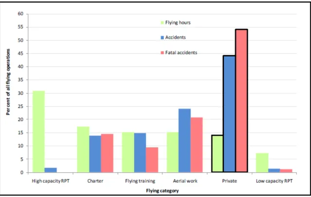
A research investigation19 conducted by the ATSB and published in 2010 reviewed trends in fatal and non-fatal accidents in private flying operations. This research found that 44 per cent of all accidents and over half of fatal accidents between 1999 and 2008 were attributed to private operations (Figure 6). These figures significantly exceeded the proportions for any other flying category, even though private operations contributed to less than 15 per cent of the hours flown in Australia in that decade.
Figure 6: Proportion of flying hours vs. proportion of accidents for all flying categories (1999-2008)
Source: ATSB
A research article20 by the US National Transportation Safety Board published in 2007 examined general aviation accidents in degraded visibility and identified several variables that were
significantly associated with accident involvement. These included:
• pilot age at the time of the accident (with the highest proportion of accidents involving pilots over 60) • pilot age at certification (with pilots certified at or before age 25 having the lowest accident involvement) • the pilot not holding an instrument rating increased the accident risk by nearly five times
• commercial pilots had a lower accident involvement than student or private pilots
• private flights had a higher accident involvement than flights conducted for commercial purposes
A comparison of the accident trends in private and other operations in Australia between 1999 and 2008 shows a difference in the relative levels of safety between commercial and non-commercial flights. Passengers should take this and the factors identified in the NTSB research into account when contemplating non-commercial flights.
Flight under the night VFR
Last light
A pilot conducting a day VFR flight was required to plan for an estimated time of arrival (after allowance for any required holding) at its destination that was at least 10 minutes before last light. Given the forecast wind conditions and the planning figures used by the pilot, the departure from Bendigo at 1711 meant that the flight would have arrived at Nhill a few minutes after last light. That would have required the last part of the flight to be conducted under the night VFR. Using the same planning data, the pilot’s original plan to depart Essendon at 1500 would have resulted in the aircraft arriving at Nhill during daylight. Similarly, and despite the delayed departure from
20 Groff, L.S. & Price, J.M. (2006). General Aviation Accidents in Degraded Visibility: A Case Control Study of
Essendon, had the aircraft not landed at Bendigo, the flight would also have arrived at Nhill before last light.
Weather
Except for some helicopter and balloon operations there is no difference between the necessary visual meteorological conditions for day and night VFR. In that context, operation in airspace associated with the flight from Bendigo to Nhill at or below the higher of 3,000 ft AMSL or 1,000 ft AGL required 5,000 m visibility and for the aircraft to remain clear of cloud and in sight of ground or water. Compliance with the latter requirement at night could be achieved by having either sufficient celestial illumination to see the surrounding terrain or water or being able to see and identify any prominent lighted objects on the ground.
In their guidance on night VFR flight, CASA recommended maintaining 1,000 ft vertical separation from cloud at night as cloud may not be visible until it has been entered. VFR flight on top of cloud was generally permitted however, note 3 of paragraph 19.2.1 of ENR 1.1 GENERAL RULES of the AIP cautioned:
Pilots should not initiate VFR flight on top of more than SCT cloud when weather conditions are marginal. Before committing to operate VFR flight on top of more than SCT cloud, pilots should be confident that meteorological information used is reliable and current, and clearly indicated that the entire flight will be able to be conducted in VMC.
As there was no aerodrome forecast that was valid for the aircraft’s estimated arrival time at Nhill, the pilot could not be confident that the flight could be completed in visual meteorological
conditions.
Lowest safe altitude
Unless being radar vectored, during the cruise a flight under the night VFR must be conducted not below the published lowest safe altitude (LSALT) or that calculated in accordance with section 4 of GEN 3.3 AIR TRAFFIC SERVICES of the AIP. The LSALT for the track between Bendigo and Nhill was not identified on any of the published charts and therefore had to be determined by consideration of the terrain within a 19 km radius of the aircraft’s nominal track on a topographical map21. Using that method, the LSALT for the final part22 of the flight was 2,100 ft. The
topographical maps recovered from the accident site did not have sufficient coverage to enable the pilot to calculate the LSALT between Bendigo and Nhill via this method.
A conservative (higher) LSALT could have been obtained more simply by considering the
published grid LSALT23 on a chart that was identified at the accident site. It was also possible, but unable to be confirmed, that the pilot used software on the recovered tablet computer to make an assessment of the required LSALT.
Civil Aviation Safety Regulation Part 61
At the time of the accident, there was no periodic renewal requirement in respect of pilots’ night VFR ratings. Similarly, although CAAP 5.13-2(0) suggested means for night VFR pilots to maintain their instrument flying skills, there was no instrument flight recency requirement in support of that rating.
Civil Aviation Safety Regulation (CASR) Part 61 Flight crew licensing was made in
February 2013 and becomes effective on 4 December 2013. Once in place, Parts 61.555 to 61.975 will introduce a 24-month requirement for pilots to have their night VFR rating reviewed. The CASR does not mandate any minimum recency requirements for instrument flight in relation to the night VFR rating.
21 Other methods were also permitted to calculate LSALT with reference to the surrounding topography.
22 The LSALT in the vicinity of Bendigo was higher due to surrounding terrain. Descent to a lower LSALT was permitted
once a visual position fix had determined that a critical obstacle had been passed.
Related occurrences
Australian occurrences
24Many aircraft accidents have occurred at night. As stated in CAAP 5.13-2(0):
Night flying accidents are not as frequent as daytime accidents because less flying is done at night. However, statistics indicate that an accident at night is about two and a half times more likely to be fatal than an accident during the day. Further, accidents at night that result from controlled or uncontrolled flight into terrain (CFIT or UFIT) are very likely to be fatal accidents. Loss of control by pilots of night visual flight rules (NVFR) aircraft in dark night conditions has been a factor in a significant number of fatal accidents in this country…
Collision with terrain at Warrnambool Airport, Victoria on 10 October 1995 - ATSB investigation 199503369
At about 1948 on 10 October 1995 the pilot of a Cessna Aircraft Company 182R, registered VH-XTK, departed Warrnambool Airport on a night VFR flight to Moorabbin, Vic. Shortly after take-off the aircraft impacted terrain and the three aircraft occupants were fatally injured. The aircraft was destroyed.
As part of the investigation into the circumstances of this accident, the ATSB (then known as the Bureau of Air Safety Investigation) identified a safety issue in respect of the training requirements for flight under the night VFR. This related to Civil Aviation Order (CAO) 40.2.2NIGHT V.F.R.
RATING AND NIGHT V.F.R. AGRICULTURAL RATINGS, which initially established the night VFR rating on 4 May 1967 as a Class 4 Instrument Rating.
The ATSB found that the original intention of the CAO was for pilots to be able to complete their journey after last light, or take off before first light. Twenty accidents were identified involving operations after last light by night VFR-rated pilots in the period 1986 to 1995.
Collision with terrain 3 km east of Newman Airport, Western Australia on 26 January 2001 – ATSB investigation BO/200100348
ATSB investigation BO/200100348 examined the circumstances of the collision with terrain that occurred 3 km east of Newman Airport, Western Australia on 26 January 2001 and involved a Cessna 310R aircraft, registered VH-HCP. The flight was conducted at night under the VFR, with one pilot and three passengers on board. All were fatally injured and the aircraft destroyed. During its investigation the ATSB identified a safety issue in respect of the requirements for pilots to maintain currency, recency and proficiency for night VFR flight under dark night conditions. In consequence, on 23 October 2002, the ATSB issued safety recommendation R20020193 that stated:
The Australian Transport Safety Bureau recommends that the Civil Aviation Safety Authority (CASA) review the general operational requirements, training requirements, flight planning requirements and guidance material provided to pilots conducting VFR operations in dark night conditions.
In response to this recommendation, on 13 December 2002, CASA advised that:
CASA acknowledges the intent of this Recommendation. As part of the proposed CASR Part 61, CASA is developing the requirements for night VFR ratings which will be based on the existing Civil Aviation Order CAO 40.2.2. In addition, a draft competency standard for night visual flight operations has been developed for inclusion in the proposed CASR Part 61 Manual of Standards. CASA plans to publish a Notice of Proposed Rule Making in relation to this matter in March 2003.
Collision with water off Cape Hillsborough, Queensland on 17 October 2003 – ATSB investigation 200304282
At about 2132 on 17 October 2003, a Bell 407 helicopter, registered VH-HTD departed Mackay Airport for Hamilton Island, Queensland (Qld) with the pilot, a crewman and a paramedic on board. The pilot transmitted a departure report for the night VFR flight and submitted an estimated time of arrival for Hamilton Island. No additional communication was received from the pilot and a subsequent search identified aircraft wreckage floating in the sea off Cape Hillsborough. The aircraft occupants were fatally injured and the helicopter destroyed on impact.
As part of its investigation into this accident, on 6 November 2003, the ATSB issued safety recommendation R20030213 to CASA recommending:
…that the Civil Aviation Safety Authority review the night visual flight requirements and promulgate information to pilots emphasising the importance, during flight planning, of considering whether: • environmental conditions allow for aircraft orientation by visual reference alone,
• there is likely to be sufficient ground or natural lighting and flight visibility along the proposed route to provide visual reference to the ground and/or water during the flight, and
• they are capable of safely operating the aircraft should non-visual conditions be encountered.
CASA responded to R20030213 on 10 December 2003 and stated, in part that:
CASA supports the issues raised in the Air Safety Recommendation and advises that the Authority is currently reviewing the night visual flight requirements with a view to emphasising to pilots, through its safety promotion activities, the importance of considering the above factors.
On 21 December 2004, CASA further responded to the recommendation and advised:
CASA does not agree that a review of night VFR requirements is necessary. Firstly, regulations specify that weather conditions of night VFR must be such that a planned flight can be conducted at a safe height clear of cloud. With respect to pilot competency, Civil Aviation Order
(CAO) 40.2.2 specifies that the night VFR rating requires pilot be trained to control an aircraft solely by reference to instruments. Any notion that celestial lighting and/or an apparent visible horizon are appropriate references for the control of an aircraft by night is misleading and dangerous and increases the probability of pilot disorientation.
On 27 January 2005, after being asked for clarification on the issue, CASA responded:
Reliance on ambient lighting at night rather than instruments for attitude reference is potentially hazardous due to the high risk of pilot disorientation. CASA strongly believes that the requirements specified in Civil Aviation Order (CAO) 40.2.2 are adequate for night VFR operations. It is the responsibility of the operators to ensure that pilots meet the requirements specified for rating issue, especially those related to instrument flying. Therefore, CASA does not believe that a review of these requirements is necessary given that Australia already has the most comprehensive night VFR pilot qualification.
Collision with water off Bokarina, Queensland on 15 August 2004 – ATSB investigation 200403006
At about 2017 on 15 August 2004, a Mooney Aircraft Corporation M20K aircraft, registered VH-DXZ, descended into the ocean off Bokarina, Qld during a night VFR return flight from Cobar, New South Wales. The owner-pilot, who was the sole occupant, was fatally injured and the aircraft was destroyed.
The ATSB investigation into this accident concluded:
The circumstances of the accident are consistent with a loss of control due to the pilot becoming spatially disoriented after flying into an area of minimal surface and celestial illumination. Physiological and cognitive factors may have contributed to the development of the accident. However, the factors that contributed to the aircraft descending into the water could not be conclusively established. This accident highlights the need for night VFR pilots to manage the risk of spatial disorientation in dark night conditions by maintaining proficiency in instrument flight.
Summary of occurrences associated with VFR operations at night 1993-2012
Appendix A provides a summary of 13 accidents in Australia from 1993 to 2012 associated with VFR operations at night. Key features of the accidents are that almost all resulted in fatalities, almost all occurred in dark night conditions, most of the pilots did not hold a current command instrument rating (CIR), and some of the pilots did not meet the recency requirements for carrying passengers at night.
United States occurrences
Safety Alert
In March 2013 the United States (US) National Transportation Safety Board (NTSB) issued Safety Alert SA-020 Reduced Visual References Require Vigilance. This alert highlighted that about two thirds of US general aviation accidents in reduced visibility weather conditions are fatal, and typically involve pilot disorientation or controlled flight into terrain. The NTSB observed that even in visual conditions, the combination of flight at night with limited ground lighting and therefore ground references could be problematic.
A number of common accident scenarios in conditions with limited ground reference were provided in the alert and strategies for pilots to manage that risk were suggested. Of note in the context of the accident near Horsham on 15 August 2011, the NTSB highlighted that:
Remote areas with limited ground lighting provide limited visual references [sic] cues for pilots, which can be disorienting…
and that pilots should:
Consider following instrument procedures if you are rated or avoiding areas with limited ground lighting (such as remote or mountainous areas) if you are not.
Angel Flight accidents
In 2007 and 2008 the NTSB investigated four accidents that involved flights that were operating as charitable medical transport flights, organised by various Angel Flight agencies. Three of the accidents occurred with patients on-board; one was a positioning flight to collect a patient. The age range of the pilots was from 57 to 81 years old.
While the circumstances of the accidents differed, the NTSB was sufficiently concerned that a number of similarities existed between the occurrences that on 9 June 2010, they issued a Safety Recommendation to the Air Care Alliance (ACA). According to their website, the ACA is a
‘nationwide league of humanitarian flying organizations whose volunteer pilot members are dedicated to community service’. The three separate Angel Flight charities that had organised the four accident flights in 2007 and 2008 were members of the ACA.
The NTSB recommended25 that the ACA:
Require voluntary pilot organizations to verify pilot currency before every flight.
Require that voluntary pilot organizations inform passengers, at the time of inquiry about a flight, that the charitable medical flight would not be conducted under the same standards that apply to a commercial flight (such as under 14 Code of Federal Regulations Part 121 or Part 135).
In conjunction with your affiliate organizations and other charitable medical transport organizations, develop, disseminate, and require all voluntary pilot organizations to implement written safety guidance, best practices, and training material for volunteer pilots who operate charitable patient transport flights under 14 Code of Federal Regulations Part 91. The information should address, at a minimum, aeronautical decision-making; proper preflight planning; pilot qualification, training, and currency; and self-induced pressure.
25 National Transport Safety Board Safety Recommendation A-10-102 through 104. See www.ntsb.gov for more
In response, the ACA issued a bulletin to their member organisations stating they shared the NTSB’s concerns and were working on safety initiatives with AOPA Air Safety Foundation and asking for involvement from member organisations in addressing the NTSB’s recommendations.
Safety analysis
Introduction
The Australian Transport Safety Bureau (ATSB) identified that, despite the aircraft being overdue for maintenance, there was no evidence that VH-POJ (POJ) was unserviceable at the time of the accident. Additionally, a review of the pilot’s medical records and post-mortem results indicated that it was unlikely that the pilot became incapacitated during the flight. In that context, this
analysis will examine the factors that led to a visual flight rules (VFR) pilot, who was reported to be cautious about flying in marginal visual meteorological conditions (VMC), losing control of an aircraft with no identified defects before impacting the ground. In addition, a number of survivability aspects that may have influenced the severity of the outcome will be discussed together with other operational factors.
Flight planning considerations
Analysis of the relatively complex weather forecast for the intended flight identified that cloud, rain and turbulence where likely to be encountered on the planned route from Essendon to Nhill. The cloud base ranged from 800 ft to 3,000 ft above sea level (AMSL) and with a top between 2,000 ft and 8,000 ft AMSL, with its extent influenced by the presence of rain. While it appeared that the pilot did not use the available Bureau of Meteorology (BoM) specialists to assist with interpreting the forecast, the account of the witnesses at Essendon Airport indicates he identified that a weather-related diversion might be required.
The pilot’s action to divert to Bendigo and access the National Aeronautical Information
Processing System (NAIPS) was consistent with concern about weather that might affect the flight to Nhill. That action ensured that any decisions relating to the remainder of the flight were based on the most up-to-date observations and forecasts. However, in combination with the delayed departure from Essendon, the diversion and time invested at Bendigo in understanding the weather affecting the remainder of the flight meant that the planned arrival time at Nhill was delayed to after last light. This required the pilot to conclude the flight under the night VFR. It is possible that the pilot’s priority to understand and manage the effect of deteriorating weather, and the resulting time taken to divert to Bendigo and access NAIPS, compressed the time available to the extent that the pilot lost awareness of or did not assimilate the implications of the approaching last light. The pilot’s initial plan to depart Essendon at 1500 would have provided minimal concern regarding the implications of last light for the arrival at Nhill. Indeed, given the forecast in-flight winds, the as-planned direct flight to Nhill would have resulted in an arrival at Nhill 19 minutes before the calculated last light of 1825.
In order to remain clear of the forecast cloud, the pilot had the option to operate below, between, or above the predicted layers of cloud. Given the elevation of the terrain between Bendigo and Nhill and the lowest level of forecast cloud, conducting the flight below the cloud would have required operation below the lowest safe altitude (LSALT). VFR operation below LSALT was permitted during daylight hours, but not at night. As a result, the option to operate below the forecast cloud would have diminished as last light approached because of the need to climb to the LSALT before the pending operation under the night VFR. Furthermore, the actual time of last light along the track between Bendigo and Nhill probably occurred earlier than the published time due to the cloud cover along that route.
The requirement to conduct the latter part of the flight to Nhill at, or above, the LSALT would have required operation above, or between, the forecast layers of cloud. Flying between the cloud layers in fading light would have increased the risk of inadvertently entering the forecast cloud and losing visual cues as well as making visual navigation difficult. As there was no valid aerodrome
forecast for the arrival at Nhill, operation above the forecast cloud would have increased the risk that descent in to Nhill could not be completed in visual meteorological conditions.
Development of the accident
Analysis of the recorded Global Position System (GPS) data retrieved from the on-board tablet computer identified that following departure from Bendigo the aircraft was initially operated between 2,000 and 3,000 ft above mean sea level with the final 20 minutes of the flight being conducted between 1,000 and 2,000 ft. Analysis of the GPS data also identified a number of minor deviations from the straight line track for the majority of the flight from Bendigo with more
significant track deviations in the final flight segment. Comparing the GPS flight profile with the BoM analysis of the likely extent and levels of cloud, it appears that the pilot was manoeuvring at the base of the clouds for the majority of the flight. Consistent with the BoM analysis, the lower altitude recorded on the GPS indicates that areas of lower cloud may have been present during the final part of the flight.
Spatial disorientation
Spatial disorientation is a type of loss of situation awareness, and is different to
geographical disorientation, or incorrectly perceiving the aircraft’s distance or bearing from a fixed location. Spatial disorientation occurs when pilots do not correctly sense their aircraft’s attitude, airspeed or altitude in relation to the earth’s surface. In terms of an aircraft’s attitude, spatial disorientation is often described simply as the inability to
determine ‘which way is up’, although the effects can often be more subtle than implied by that description.
Spatial disorientation occurs when the brain receives conflicting or ambiguous information from the sensory systems. It is likely to happen in conditions in which visual cues are poor or absent, such as in adverse weather or at night.26 Spatial disorientation presents a danger to pilots, as the resulting confusion can often lead to incorrect control inputs and resultant loss of aircraft control.
At 1811, 14 minutes after sunset and 13 minutes before published last light, the aircraft’s track, speed and altitude recorded on the tablet computer’s GPS became increasingly erratic. The aircraft impacted the ground 9 minutes later, 4 minutes before published last light and 23 minutes after sunset. At that time there was no celestial or significant ground lighting and the probable extent of cloud would have resulted in actual last light occurring earlier than the published time. That assessment was consistent with the observations of a witness who visited the site the following night at about the time of the accident and reported that it was ‘pitch black’. As stated previously, dark night conditions increased the risk of the aircraft entering low cloud associated with the reported rain in the area during the last 9 minutes of the flight.
Several witnesses who saw or heard the aircraft reported that it was raining at the time, including one witness who observed the aircraft immediately prior to impact. Rain on the windscreen would have further reduced the pilot’s ability to see external visual cues and increased the workload associated with the flight.
Examination of the landing light indicated that it was illuminated at impact, which may have affected the pilot’s night vision due to light reflecting back from cloud or rain. The ATSB also determined that the pilot was using a tablet computer during the flight, with the potential for its lighting to degrade his night vision in an already difficult situation. Although the computer screen was dimmable, the setting at the time of the accident could not be determined.Consequently, the effect of the computer’s light level on the pilot’s night vision was unable to be established but it may have been another element that limited the pilot’s vision outside of the cockpit.
26 More information about spatial disorientation can be found in the ATSB aviation research and analysis report
The ATSB concluded that due to either the weather and/or dark night conditions, the pilot probably became spatially disorientated after losing adequate visual cues and attempted to fly the aircraft visually or with sole reference to instruments or a combination of both methods. Any increased workload and detrimental effect on identifying external visual cues associated with using the computer and possible distraction associated with reflected light, would have increased the likelihood for that to occur.
Managing reduced night visual cues
The aircraft’s track following Wallup was inconsistent with controlled visual or instrument flight. Due to the probable lack of adequate visual cues, it is reasonable to assume the pilot was at least partially flying on instruments after Wallup. The pilot had limited recent instrument flying
experience, and may have experienced difficulties in maintaining control with reference to the flight instruments.
While the pilot was qualified to fly at night under the VFR, an important consideration for planning such a flight, in addition to weather, should be the amount of ambient light available. The
deterioration in visual cues due to the dark night would have occurred in addition to, and was probably exacerbated by, the marginal weather encountered. It is possible that the pilot did not consider the effect of the dark night on the availability of visual cues prior to, or during the flight, and instead was focused on the weather conditions in the area.
Pilot decision making
The pilot was reported to be cautious in his operational decision making when deteriorating weather conditions were forecast. He had cancelled a number of previous Angel Flights due to poor weather. All but one of those flights was cancelled prior to its commencement, with the other one being cancelled airborne as the pilot repositioned to collect his passengers. On that occasion the pilot received a clear indication from air traffic services that the weather conditions on track were unsuitable for continued flight under the VFR. By contrast, the accident flight occurred during the return of the passengers to their home and the pilot may therefore have felt a degree of investment in the mission and a motivation to complete the flight. There was insufficient evidence to determine if the pilot might have experienced such self-induced pressure. Additionally, the reported desire of one of the passengers to return home due to family commitments and the possible receipt of a favourable weather report from an observer at Nhill also had the potential to influence the pilot’s operational decision making. However, the ATSB was unable to determine if that occurred.
In consideration of any pressure from the passengers for the pilot to attempt to complete the flight, Angel Flight clearly stated that its pilots in command were in charge of passenger transport flights and must decide the acceptability of changes to a flight, and the necessity or otherwise to
complete a flight. In addition, prior to flight, Angel Flight passengers formally acknowledged that their flight may not be able to be completed, including due to inclement weather and other in-flight factors, and that they may need to provide for alternate transport to complete their journey. Despite that, the (United States) Aircraft Owners and Pilots Association training course ‘Public Benefit Flying: Balancing Safety and Compassion’ identified that pilots conducting volunteer humanitarian flights may be exposed to factors that are detrimental to safe decision making.
Survivability
Examination of the aircraft wreckage and occupants identified that the pilot was in the left-front seat and the two passengers were positioned in the rear seats. It was also established that the right-rear seat belt was probably unfastened at the time of the impact. Post-mortem examination of the passengers did not identify any evidence of seatbelt-related injury and, as such, it could not be established which of them had been unrestrained. Recognising that the use of installed harnesses will generally minimise the risk of injury during a collision with terrain, the ATSB could
not determine whether the failure to use the seat belt influenced occupant survivability on this occasion.
The failure of the installed emergency locator transmitter (ELT) to automatically activate, due to the characteristics of the impact, prevented the timely notification of the accident and identification of the aircraft location. In addition, the ELT operated on a frequency that was not monitored by the Rescue Coordination Centre (RCC) and was therefore of limited use. The pilot was reported to have carried a personal locator beacon (PLB) which, although requiring manual activation, would have been detectable by the RCC. No PLB was found at the accident site.
The nominated SARTIME was at least 1.5 hours after the estimated arrival of POJ at Nhill. A SARTIME closer to the estimated arrival time would have identified earlier that the aircraft had not arrived at Nhill and allowed a more timely response and provision of assistance. Although in this instance witnesses provided notification of the accident, the availability of accurate flight
information will generally provide for a faster emergency response.
Minimum requirements for night flights
It is widely agreed that flying at night under the VFR is more difficult than during the day because of the reduction in available visual cues. Most night flights are not conducted in dark night conditions, and in those cases the existing minimum regulatory requirements and supporting guidance from Civil Aviation Advisory Publication (CAAP) 5.13-2(0) Night Visual Flight Rules Rating may well be sufficient.
However, there is a significant increase in risk between situations where there is some ambient illumination and/or ground lighting available and dark night situations where no external visual cues are available. In dark night situations, VMC is effectively the same as instrument
meteorological conditions (IMC). The only real difference is that, if there are lights on the ground, they can be seen in VMC. In remote areas where there are no lights or ambient illumination, there is no difference. Pilots cannot see the ground and have no external cues available to assist with their orientation. In addition, inadvertent entry into cloud is more likely at night because the cloud is harder to see (UK CAA 2007).
Although there is no effective difference between IMC and VMC on a dark night in areas with no ground lighting, there were no regulatory requirements regarding pilot recency to ensure that holders of night VFR ratings maintained a level of instrument flying proficiency that is essential for safe flight at night.
The ATSB has been concerned about the safety of VFR flights in dark night situations for many years, and has previously issued recommendations on the issue. CASA subsequently introduced CAAP 5.13-2(0), which provides a significant amount of guidance for operators and pilots
conducting night operations. Although the CAAP strongly emphasises the importance of flying with reference to the flight instruments, and that pilots should maintain proficiency on flying on
instruments, night VFR is still based on visual procedures. In dark night conditions, a pilot needs to fly with sole reference to the flight instruments, and should ideally have a demonstrated ability to fly to an IFR standard to ensure an adequate level of safety, particularly when passengers are being carried.
CASA has recently introduced (in February 2013) Civil Aviation Safety Regulation Part 61 Flight crew licensing, which in part requires a pilot with a night VFR rating to be assessed at least every 2 years in night operations to maintain that rating. This will certainly help maintain some pilots’ ability to a higher level than previously, but it will not ensure that the skills are retained between assessments.
In summary, the ATSB continues to be concerned that the current minimum requirements for night VFR operations are not sufficient to ensure an adequate level of safety for operations conducted in dark night situations. At present the safety of operations under the night VFR in dark night
conditions relies solely on the judgement of operators and pilots to ensure their own minimum standards are well in excess of the regulatory requirements.
Other efforts to reduce the risk of night operations
The United States National Transportation Safety Board (NTSB) recently issuedSafety Alert SA-020 Reduced Visual References Require Vigilance. The alert included the following guidance:
Remember that, when flying at night, even visual weather conditions can be challenging. Remote areas with limited ground lighting provide limited visual references cues for pilots, which can be disorienting or render rising terrain visually imperceptible. When planning a night flight, use
topographical references to familiarize yourself with surrounding terrain. Consider following instrument procedures if you are rated or avoiding areas with limited ground lighting (such as remote or
mountainous areas) if you are not.
The ATSB strongly supports such guidance, and advises all operators and pilots considering night flights under the VFR to systematically assess the potential for the flight to encounter dark night conditions by considering weather conditions, celestial illumination and available terrain lighting. If there is a likelihood of dark night conditions, the flight should only be conducted by a pilot having a high degree of instrument flying proficiency in an aircraft that is equipped to a similar standard.
Findings
From the evidence available, the following findings are made with respect to theloss of control and collision with terrain that occurred 31 km north of Horsham Airport, Victoria on
15 August 2011 and involved Piper PA-28-180 Cherokee aircraft, registered VH-POJ. They should not be read as apportioning blame or liability to any particular organisation or individual.
Contributing factors
• The pilot departed Bendigo for Nhill under the visual flight rules with a high risk of
encountering forecast cloud and dark night conditions and of subsequent loss of control due to loss of visual reference.
• Due to the presence of cloud, rain and darkness the pilot probably experienced a loss of visual cues and became spatially disorientated leading to a loss of control and impact with terrain.
• Aerial work and private flights were permitted under the visual flight rules in dark night conditions, which are effectively the same as instrument meteorological conditions, but without sufficient requirements for proficiency checks and recent experience to enable flight solely by reference to the flight instruments. [Safety issue]
Other factors that increased risk
• One of the passengers probably did not use the installed seatbelt, resulting in a greater risk of injury during the collision with terrain.