Mohd Shafry Mohd Rahim1,Abdul Rashid Mohamed Shariff2, Shattri Mansor2, Ahmad Rodzi Mahmud2,Mohammad Ashari Alias 1
1Faculty of Computer Science and Information System, University Tech-nology Malaysia, 81310 Skudai, Johor, Malaysia.
{shafry, ashari} @fsksm. utm.my,
2Institute of Advance Technology, University Putra Malaysia, 43400 Ser-dang, Selangor, Malaysia.
{Rashid, shattri, arm}@eng.upm.edu.my
Abstract
This paper summarizes the Volumetric Spatiotemporal Data Model which has been developed to manage surface movement in the Virtual Geo-graphical Information Systems (VGIS). Volumetric is one type of spatial object in the VGIS, which is used to develop visualize 3D information. In order to develop real process in VGIS, temporal element is an important issue to integrate with 3D object. Here, we propose one spatiotemporal data model used to manage volumetric surface movement according to movement criteria used in VGIS. Time has been integrated with the data model and temporal version of volumetric surface data can be stored by using the model. This model has been implemented by developing proto-type of visualization system using Triangulation Irregular Network (TIN) with integrated time in the TIN structure. Result shows that the data model which has been proposed can work with a visualization algorithm using linear interpolation and improvement TIN structure.
Keywords: Volumetric and 3D, Spatiotemporal Data Model, Database, TIN, VGIS.
1
Introduction
In VGIS or GIS, volumetric and dynamic phenomena are, by definition, multi-dimensional, which means that they are conceptually and computa-tionally challenging. Dynamic phenomena refer to movements which con-tribute to changes in geographic features. Some of the changes or move-ments may contribute to changes of the geometric object. The challenge becomes greater when we consider large-scale geographic processes. In many cases, simply introducing an additional orthogonal axis (Z) is con-venient but insufficient, because important spatial and temporal character-istics and relationships may be indiscernible in this approach. Although visualization techniques for three or more dimensions have become popu-lar in recent years, data models and formal languages have not yet fully developed to support advanced spatial and temporal analysis in multiple dimensions (Yuan M., et. al, 2000).
In this research, the discussion focuses on the volumetric surface movement in the real world, and we develop spatiotemporal data model which suitable to manage volumetric surface movement data call Volumet-ric Spatiotemporal Data Model. Besides that, the discussion also focuses on the implementation of Volumetric Spatiotemporal Data Model and de-velopment of prototyping application to simulate volumetric surface move-ment.
2
Spatiotemporal Data Model and Its Visualization
In GIS, data model is the abstraction of the real world phenomena accord-ing to a formalized, conceptual scheme, which is usually, implemented us-ing the geographical primitives of points, lines, and polygons or discred-ited continuous fields (Nadi, S., et. al. 2003). Data model should define data types, relationship, operations, and rules to maintain database integ-rity (Nadi, S., et. al. 2003). In the VGIS, data model also with the same meaning with enhancing to focus on the 3D data. Spatiotemporal Data Model in VGIS is an abstraction of managing 3D spatial with the temporal element. Spatiotemporal data model is very important to create a good da-tabase system for VGIS which deals with space and time as a main factor in the system (Rahim M.S.M, et. al, 2005).
Ori-ented Spatial Temporal Data Model (Bonan, L., and Guoray, C.2002), Multigranular Spatiotemporal Data Model (Elena, C, et. al. 2003) and Fea-ture-Based Temporal Data Model (Yanfen, L. 2004). They are several is-sues has been addressed from the researchers. In our observation, the spa-tiotemporal data modeling is lacking the foundation of understating real world phenomena. In the future, the foundation of spatiotemporal is very important to be considered to develop real-time process in GIS (Rahim M.S.M, et. al, 2005). Very interesting spatiotemporal data model should be focus on the volumetric data and geographic movement behavior in order to created VGIS with a realistic process.
Other issue which is related to the capability of spatiotemporal data model is visualizing 3D or volumetric spatiotemporal object in order to in-crease user understanding in the geographic phenomena and make some simulation or prediction in the future. Thus, data model must have capabil-ity to do user query for visualizing information on the 3D with movement in the VGIS. This is very challenging issue. This issue also addressed by John. et. al. (2004) to development of techniques and tools that are simply unable to cope when expanded to handle additional dimensions.
3
Formalism Volumetric Surface Movements
In the real world, all objects are volumetric. It is very difficult to manage the volumetric object. So, volumetric object can be presented in the 3D ob-ject. Focus of this discussion is to identify the movement criteria which can be use to develop spatiotemporal data model.
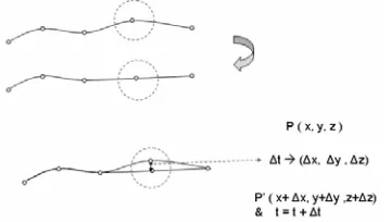
Volumetric surface movement always involve with transformation of the set of point in the surface. Figure 1 shows the process of movement in the volumetric surface.
Definition 1: AVolumetric Surface Movement(mv) consists of two pa-rameters which are volumetric object (v), and time (t)
Volumetric surface object (v) is a set of geometric object which is cre-ated by the surface -7 triangle -7line -7point
Time (t) which represents the period of changes and duration of changes.
Definition 2: Time (t) changes continuously. When Object (v) and At-tribute (a) change, time (t) acts as reference of the change process. I1t will present period of change. I1t has a start time tsand end time t, representing duration of a change.
ob-Volumelrtc+Time
(x.y.z)+Ifor Po int
ject to identify period and duration of change will change accordingly. Time (t) belonging to object represents changes or movement events.The basic requirement for construction of a volumetric object is a point(P).So,
for reconstruction of the volumetric moving object, we must add time pa-rameter in the representation of the point (P),i.e.,(x ,y, z,t).
~
Time start~
_
~
mm~ ~
Fig.1.Volumetric Surface Movement
From the definitions, we can say that movement on the surface happens
during point which is created the volumetric surface. We can precisely shown, as in Figure 2,that movement will change location of the point to a new point and generate a new line which contribute to changes the volu
-metric surface.
P(x.y.z)
,.' "
p'(x+llx.y+lly.z+ll zl
& I-I +lll
Fig. 2. Transformationof point within one line
show the direction of movement when volumetric surface object was
changing from one state at certain time to another time.
Tabl e1:Descriptionof Transformation Point in VolumetricSurface Movement No Stateof PointMovement Direction of Movement
1
(
I
oxl
&l
oy
l
&l
ozl)
=
0 2(I
ox
l
>0)&(
Ioyl
&l
o
zl)
=
0 3(
I
ox
l
&l
o
zi)
=0&l
o
yl)
>04
(I
oxl
&l
o
yl)
=
0&(
l
oz
l)
>0 5(
Ioxl
&l
o
yl)
>0&l
ozi)
=
06
(
Ioxl
&l
oz
i)
>0&loyl)
=
07
(
Ioyl
&l
ozi)
>0&l
oxl)
=
0 8C10
x
l
&l
o
yl
&l
ozJ)
>0Xaxis yaxis
zaxis
x&yaxis x& z axis y& z axis x& y& z axis
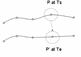
Movement can be visualized simply by using the linear interpolation
model. Figure 3 show the process of interpo lation.
PatTs
P'at Te
Fig.3.LinearInterpolationProcess for Simulating Movement
Based on the figure 3, Let Ptx, y, z) at time start Ts and move into
P'(x',y',z') at Te. So, the movement process changes withinthe three axis
which areL1x
=x
'- x,L1y=y' - y, L1z
=
z'- zandL1t=
Te - Ts.The nextpoint P', is the previous point P, and added with differences within the
axis.The next pointcan be calculateasx'
=x
+L1x, y'=y
+L1y, z'=
z +L1z, andTe
=
Ts+L1t.4
Volumetric
Spatiotemporal Data Model
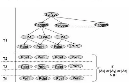
By using a formalism which hasbeen definedin thesection 3,Volumetric
Spatiotemporal Data Model will be proposed and discussed. In the data
model, it is important to define the geometric of the object for storing and
retrieval purpose. Based on theformalism,every point must have atime as
Usually data are collected based on the version approach. We need to manage especially in term of the volumetric surface movement. It means that, every time data was collected, user had identified the movement or changes happened in a space. This will be a basic of the spatiotemporal data model development. This situation can be transform into mathemati-cal equation to define fundamental of proposed data model.
Definition 4: Assume that version of spatial data are f(t1), f(t2),., f(tm).
Object at time 1:
F(t1)
={
<x1,y1,zl,t1>, <x2,y2,z2,t1>, ... <xn.yn.zn.tl>, } Object at time 2:F(t2)
={
<x1,y1,zl,t2>, <x2,y2,z2,t2>, ... <xn.yn.zn.t?», } Object at time:F(tm)
={
<x1,y1,zl,tm>, <x2,y2,z2,tm>, ... <xn.yn.zn.tm>, }Definition 5: Letf(mv) is define as volumetric surface movement proc-ess. So, Set of Volumetric Movement data is union of all set of version data.
f(mv)
=
{<x1,y1,zl,t>, <x2,y2,z2,t>, ... <xn.yn.zn.t»] U { <x1,yl,zl,t2>, <x2,y2,z2,t2>, <xn.yn.m.t?>, } U { <x1,y1,zl,tm>, <x2,y2,z2,tm>, <xn.yn.zn.tm>, }In real process, not all the points in the volumetric surface changing or move. The question is, is it necessary to store all the points, which will in-crease the storage usage in the implementation? To avoid data redundancy, the data model must be able to identify which point has been changing. To identify, data model must have capability to check every point among ver-sion of data and capture the changes point. To perform this task, the for-malism in the section 3 will be used. The conceptual identification is:
If <x1,y1,zl,tn> - <xl,yl,zl,tn+l>=O, data at tn+1 equal to data at tn, else <x1,y1,zl,tn> - <x1,yl,zl,tn+1> -;;= 0 , data for tn+1 is <x1,yl,zl,tn+1>
Fig. 4. Volumetric Spatiotemporal Data Model
5
Data Model Implementation and Results
In the implementation phase, data model has been developed by using Re-lational Database Model which has been acceptable for many databases systems. Prototyping of visualization system has been developed with it's data format for visualizing the volumetric surface movement data.
Structure of the databases has been design to store a series of point which created a surface with the line and the polygon. Every point which stored in the database will be incorporated with time entity. There are fours major entities: point, line, polygon, and surface. In the database,a simple structure of database has been design as bellow:
Points (Idjroint, Time, x, y, z)
Line (Id_line, Point1,Point 2)
Polygon (Idpolygon. Line1,Line2,Line 3)
Polygon is based on the TIN structure which created triangle surface
Surface (Id_Surface, Time, Polygon1,Polygon2, ...Polygon n)
6
Conclusion and Future Works
According to Mountrakis, G., et. al. (2005), a successful GIS query process should be able to support difference user preferences in spatiotemporal scene queries, and do not have a fixed-metric approach where all users are considered equal. These required spatiotemporal databases can integrate all of series of data. Volumetric Spatiotemporal Data Model can be an idea to resolve this kind of issue. All changes of the volumetric surface movement had been integrated into single database system which reduces their redun-dancy of data. This will give advantages in design analysis and manipula-tion of the spatiotemporal data based on the user requirement. In the near future Volumetric Spatiotemporal Data Model will be tested with a real application related with morphology of limestone are which involve suit-able to evaluate the data model as well as prototyping of visualization ap-plication.
In the future, proposed model need to be modified to take into account the uncertainties in data movement in the surface. This data model can handle only fix number of points only, which may not the case in real dy-namic world. Currently when this issue arises, we coordinate the number of point to become the same with previous data. Besides that, improve-ment of the Volumetric Spatiotemporal Data Model can be done in the im-plementation aspect. Several issues need to be enhanced to index the spati-otemporal data which is always increasing, and formalize spatispati-otemporal query according to surface movement.
As a conclusion, our major contribution in this paper is, proposing spa-tiotemporal data model which has the capability to manage volumetric sur-face movement. Besides that, the TIN structure has been used with slight modification with temporal element which requires development of visu-alization system.
7
Acknowledgments
References
Yuan, M., D. M. Mark, M. J. Egenhofer, and D. J. Peuquet, 2004. Extensions to Geographic Representations. Chapter 5 in R. B. McMaster and E. L. Usery (eds.), A Research Agenda for Geographic Information Science, Boca Raton, Florida: CRC Press, 129-156
Nadi, S., Delavar, M.R. (2003) Spatio-Temporal Modeling of Dynamic Phenom-ena in GIS, ScanGIS 2003 Proceeding, p.p 215-225
Rahim M.S.M, Shariff A.R.M, Mansor S., Mahmud A.R. (2005), A Review on Spatiotemporal Data Model For Managing Data Movement in Geographical Information Systems (GIS), Journal of Information Technology, FSKSM, UTM, Vol 1, Jld 9, December, p.p 21 -32
Narciso, F.E. (1999) A Spatiotemporal Data Model For Incorporating Time In Geographical Information Systems (GEN-STGIS), Doctor of Philosophy in Computer Science and Engineering, University of South Florida, April. Ale, R., Wolfgang, K. (1999) Cell Tuple Based Spatio- Temporal Data Model: An
Object Oriented Approach, Geographic Information Systems, Association of Computing Machinery (ACM) Press New York, NY, USA, 2-6 November, p.p 20-25
Moris, K. , Hill, D. , Moore, A. (2000), Mapping The Environment Through Three-Dimensional Space and Time, Pergamon, Computers, Environment and Urban Systems Vol 24 , p.p 435-450
Donggen, W. , Tao, C. (2001) A Spatio-temporal Data Model for Activity-Based Transport Demand Modeling, International Journal of Geographical Informa-tion Science, Vol. 15, p.p: 561-585.
Philip, J.U. (2001) A Spatiotemporal Data Model for Zoning, Masters of Science Thesis, Department of Geography, Brigham Young University
Bonan, L.,Guoray, C. (2002) A General Object-Oriented Spatial Temporal Data Model, Symposium on Geospatial Theory, Processing and Applications, Ot-tawa, March.
Elena, C, Commossi, Michela, B. Elisa, B. Giovanna, G. (2003) A Multigranular Spatiotemporal Data Model, GIS'03, New Orleans, Louisiana, USA, November 7-8, p.p 94-101
Yanfen, L. (2004) A Feature-Based Temporal Representation and Its Implementa-tion with RelaImplementa-tional Schema for Base Geographic Data in Object-Based Form, UCGIS Assembly.
Roddick, J.F., Egenhofer, M.J, Hoel E., Papadias D, (2004), Spatial, Temporal, and Spatiotemporal Databases, SIGMOD Record Web Edition, Vol 33, No.2, June 2004.