CHANGES DETECTION IN LAND USE LAND COVER PATTERN
KODAIKANAL TOWN, DINDIGUL DISTRICT
*,1
Uma Maheswari, R.,
2Ohm Rajkumar. R.,
1
Department of Zoology, A P A College for Women, Palani, India
2
Junior Research Fellow, UGC Major Project, Palani, India
2
Scientist-E, Centre for Earth and Atmospheric Sciences,
4
Department of Zoology, The Madura College, Madurai,
ARTICLE INFO ABSTRACT
Land use and land cover changes of Kodaikanal hills by using multi
monitor the changes in various land use / land cover classes using digital remote sensing techniques. The spatial coverage of each class may be visualized on both maps. The area of each class for the year 2006 and 2011 data has been
methodology of (Anderson
spatial coverage of each class may be visualized on both maps. The area of each class for the year 2006 and 2011 data has been compiled. The land use/ land cover map of year 2006, depicts that built up area constitutes 14% of total area, while the agriculture classes like Crop land, Fallow and Plantation covers 36% the study area. Water bodies and Barren
respectively. The forest classes like forest plantation, forest Deciduous, Forest scrub and forest evergreen covers 49% in the study area. In year 2011, the built up area obtained from digital image processing techniques ha
shows an area of 9.5% decrease in agriculture land. The water bodies cover 1% and the barren area is converted in to built
forest covers 38% of the study area. The decreased classes in the agriculture and forest are converted in to built
detect vegetation change and
crop land and plantation has been decreased within the period 2006 identified
a sustainable
Copyright © 2015 Uma Maheswari et al. This is an open access article distributed under the Creative Commons Att use, distribution, and reproduction in any medium, provided the original work is properly cited.
INTRODUCTION
Land use and land cover is an important
understanding the interactions of the human activities with the environment and thus it is necessary to be simulate changes. Empirical observation revealed land use land cover classification in Kodaikanal taluk, a Western Ghats located in Tamilnadu state. Land
cover change is a general term for the human modification of Earth's terrestrial surface. Though humans have been modifying land to obtain food and other ess
thousands of years, current rates, extents and
intensities of LULCC are far greater than ever in history,
*Corresponding author:Uma Maheswari,R.
Department of Zoology, A P A College for Women, Palani, India.
ISSN: 0975-833X
Article History:
Received 19th February, 2015
Received in revised form 17th March, 2015
Accepted 08th April, 2015
Published online 31st May,2015
Key words:
Land Use,
Land Cover Change, Kodaikanal, Land sat, LULCC,
Vegetational changes.
Citation: Uma Maheswari, R., Ohm Rajkumar. R., Surendran, A.
pattern using remote sensing and Gis in Kodaikanal town, Dindigul District”
RESEARCH ARTICLE
IN LAND USE LAND COVER PATTERN USING REMOTE SENSING AND GIS IN
KODAIKANAL TOWN, DINDIGUL DISTRICT
Ohm Rajkumar. R.,
3Surendran, A. and
4Krishnamoorthy, S
of Zoology, A P A College for Women, Palani, India
Junior Research Fellow, UGC Major Project, Palani, India
E, Centre for Earth and Atmospheric Sciences, Sathyabama University, Chennai, India
Department of Zoology, The Madura College, Madurai,
India
ABSTRACT
Land use and land cover changes of Kodaikanal hills by using multi
monitor the changes in various land use / land cover classes using digital remote sensing techniques. The spatial coverage of each class may be visualized on both maps. The area of each class for the year 2006 and 2011 data has been compiled. The land use/ land cover maps prepared using t methodology of (Anderson et al., 1976) (LISS-III data of 2006) and (LISS
spatial coverage of each class may be visualized on both maps. The area of each class for the year 06 and 2011 data has been compiled. The land use/ land cover map of year 2006, depicts that built up area constitutes 14% of total area, while the agriculture classes like Crop land, Fallow and Plantation covers 36% the study area. Water bodies and Barren
respectively. The forest classes like forest plantation, forest Deciduous, Forest scrub and forest evergreen covers 49% in the study area. In year 2011, the built up area obtained from digital image processing techniques has been 34% of the total area. The agriculture covers an area of 26.5% which shows an area of 9.5% decrease in agriculture land. The water bodies cover 1% and the barren area is converted in to built-up area. The forest classes also showed a decrease of 10
forest covers 38% of the study area. The decreased classes in the agriculture and forest are converted in to built-up area which clearly shows the population increase. The study was successfully able to detect vegetation change and concluded that the area of the urban has increased whereas the area of crop land and plantation has been decreased within the period 2006
identified as one of the biodiversity area in India. Proper land sustainable development of Kodaikanal Taluk.
is an open access article distributed under the Creative Commons Attribution License, which use, distribution, and reproduction in any medium, provided the original work is properly cited.
is an important component in
human activities with thus it is necessary to be able to changes. Empirical observation revealed a change in ication in Kodaikanal taluk, a part of Land-use and land-is a general term for the human modification of Earth's terrestrial surface. Though humans have been modifying land to obtain food and other essentials for
thousands of years, current rates, extents and
intensities of LULCC are far greater than ever in history,
Department of Zoology, A P A College for Women, Palani, India.
driving unprecedented changes in ecosystems and
environmental processes at local, regional and global scales. These changes encompass the greatest environmental concerns
of human populations today, including
change, biodiversity loss and the pollution of water, soils and air. Monitoring and mediating
LULCC while sustaining the production of essential resources has therefore become a major priority of researchers and policymakers around the world.
cover date to prehistory and are the direct and i consequence of human actions to secure essential resources. This may first have occurred with the burning of areas to enhance the availability of wild game and accelerated dramatically with the birth of agriculture, resulting in the extensive clearing (deforestation
terrestrial surface that continues today. More recently,
Available online at http://www.journalcra.com
International Journal of Current Research
Vol. 7, Issue, 05, pp.15969-15974, May, 2015
INTERNATIONAL
Uma Maheswari, R., Ohm Rajkumar. R., Surendran, A. and Krishnamoorthy, S, 2015. “Changes detection in land use land cover in Kodaikanal town, Dindigul District”, 7, (5), 15969-15974.
USING REMOTE SENSING AND GIS IN
Krishnamoorthy, S.
of Zoology, A P A College for Women, Palani, India
Junior Research Fellow, UGC Major Project, Palani, India
Sathyabama University, Chennai, India
India
Land use and land cover changes of Kodaikanal hills by using multi-sensor satellite data and to monitor the changes in various land use / land cover classes using digital remote sensing techniques. The spatial coverage of each class may be visualized on both maps. The area of each class for the year compiled. The land use/ land cover maps prepared using the III data of 2006) and (LISS-III data of 2011). The spatial coverage of each class may be visualized on both maps. The area of each class for the year 06 and 2011 data has been compiled. The land use/ land cover map of year 2006, depicts that built up area constitutes 14% of total area, while the agriculture classes like Crop land, Fallow and Plantation covers 36% the study area. Water bodies and Barren land covers 1% and 4.5% of area respectively. The forest classes like forest plantation, forest Deciduous, Forest scrub and forest evergreen covers 49% in the study area. In year 2011, the built up area obtained from digital image s been 34% of the total area. The agriculture covers an area of 26.5% which shows an area of 9.5% decrease in agriculture land. The water bodies cover 1% and the barren area is up area. The forest classes also showed a decrease of 10% area and the present forest covers 38% of the study area. The decreased classes in the agriculture and forest are converted up area which clearly shows the population increase. The study was successfully able to concluded that the area of the urban has increased whereas the area of crop land and plantation has been decreased within the period 2006-2010. Kodaikanal area is India. Proper land use planning is essential for
ribution License, which permits unrestricted
unprecedented changes in ecosystems and
environmental processes at local, regional and global scales. These changes encompass the greatest environmental concerns
of human populations today, including climate
loss and the pollution of water, soils and air. Monitoring and mediating the negative consequences of LULCC while sustaining the production of essential resources has therefore become a major priority of researchers and policymakers around the world. Changes in land use and land cover date to prehistory and are the direct and indirect consequence of human actions to secure essential resources. This may first have occurred with the burning of areas to enhance the availability of wild game and accelerated dramatically with the birth of agriculture, resulting in the deforestation) and management of Earth’s terrestrial surface that continues today. More recently,
INTERNATIONAL JOURNAL OF CURRENT RESEARCH
industrialization has encouraged the concentration of human populations within urban areas (urbanization) and the depopulation of rural areas, accompanied by the intensification of agriculture in the most productive lands and the abandonment of marginal lands. All of these causes and their consequences are observable simultaneously around the world today. Land use/ land cover mapping is essential component where in other parameters are integrated on the requirement basis to drive various developmental index for land and water resource.
Land use refers to man’s activities and the varied uses which
are carried on over land and land cover refers to natural
vegetation, water bodies, rock/soil, artificial cover and others noticed on the land. The methods of land-change science include remote sensing and geospatial analysis and modeling, together with the interdisciplinary assortment of natural and social scientific methods needed to investigate the causes and consequences of LULCC across a range of spatial and temporal scales.( Robert Pontius, 2013; Uma Maheswari et al., 2015).
Remote Sensing Based Change Analysis
There are several urban applications where satellite based remotely sensed data are being applied, namely, urban sprawl/ urban growth trends, mapping and monitoring land use/ land cover, urban change detection and updation, urban utility and infrastructure planning, urban land use zoning, urban environment and impact assessment, urban hydrology, urban management and modeling (Raghavswamy, 1994). Remote sensing technology and geographic information system (GIS) provide efficient methods for analysis of land use issues and tools for land use planning and modeling. By understanding the driving forces of land use development in the past, managing the current situation with modern GIS tools, and modeling the future, one is able to develop plans for multiple uses of natural resources and nature conservation. The change in any form of land use is largely related either with the external forces and the pressure builtup within the system (Bisht and Kothyari, 2001; Thomas et al., 2014; Ward et al., 2014).Remote sensing techniques offer benefits in the field of land use/ land cover mapping and their change analysis. One of the major advantages of remote sensing systems is their capability for repetitive coverage, which is necessary for change detection studies at global and regional scales. Detection of changes in the land use/ land cover involves use of at least two period data sets (Jenson, 1986). The changes in land use/ land cover due to natural and human activities can be observed using current and archived remotely sensed data (Luong, 1993).
Land use/ land cover change is critically linked to natural and human influences on environment. With the availability of multi-sensor satellite data at very high spatial, spectral and temporal resolutions, it is now possible to prepare up-to-date and accurate land use/ land cover map in less time, at lower cost and with better accuracy (Kachhwaha, 1985). Keeping the above in view, the present work has been undertaken to prepare the multi-date land use/ l and cover maps of Kodaikanal from multi-sensor satellite data and to monitor the changes in various land use/ l and cover classes using digital remote sensing techniques.
Study area
Kodaikanal is one of the most popular hill stations in Tamil Nadu. It is a striking hill resort on the Palani hills in the Dindigul district of TamilNadu (Fig.1). Located 120 Km/75 mile away from Madurai, Kodaikanal is a beautiful hill station at an altitude of about 2133 m on the southern tip of upper Palani hills in Tamil Nadu in the Western Ghats. With
her wooded slopes, mighty rocks, enhancing waterfalls
and a beautiful lake, Kodaikanal will mesmerize any visitor. Kodaikanal Taluk geographically located in west part of
Dindigul district, it lies between 10 06’38”N to 10 026’57”N
Latitudes and 77 016’00”E to 77 044’56”E longitudes, its
covering 1081.33 sq.km (108133 Hectares). Kodaikanal is located in the Palani Hills which are a direct branch of the Western Ghats. Interestingly enough, the Western Ghats are considered to be the oldest mountain range in the world, composed of rock that is said to be billions of years old Study area administratively located in south direction of Palani Taluk, west direction of Dindigul Taluk, east direction of Udamalpet Taluk and north east part of Kerala State. The temperature of Kodaikanal is quasitemperate, with summer (April-May) temperatures touching 24°C maximum, 13°C minimum. Winter (December-January) temperatures hover between 16°C
maximum and 7°C minimum. Rainfall is well
distributed throughout the year, with an average precipitation of 1300 mm. annually. The climate of Kodaikanal is very unique, with a temperate fall, winter, and spring and a mild summer. Kodaikanal also receives a large amount of rainfall every year, making it an ideal environment for cultivation. Therefore, many varieties of fruits and vegetables are grown in the Kodaikanal region, many of which can only be grown here including: peaches, pears, grapes, plums, guava, jackfruit, hillbanana, passion fruit, cauliflower, potatoes, garlic, carrots, and coffee.
Demographics
Kodaikanal is small village located in Kodaikanal Taluka of Dindigul district, Tamil Nadu with total 754 families residing. The Kodaikanal village has population of 2831 of which 1452 are males while 1379 are females as per Population Census 2011. In Kodaikanal village population of children with age 0-6 is 297 which makes up 10.49 % of total population of village. Average Sex Ratio of Kodaikanal village is 950 which is lower than Tamil Nadu state average of 996. Child Sex Ratio for the Kodaikanal as per census is 868, lower than Tamil Nadu average of 943. Kodaikanal village has higher literacy rate compared within Tamil Nadu. In 2011, literacy rate of Kodaikanal village was 82.40 % compared to 80.09 % of Tamil Nadu. In Kodaikanal Male literacy stands at 87.70 % while female literacy rate was 76.87 %. As per constitution of India and Panchyat Raaj Act, Kodaikanal village is administrated by Sarpanch (Head of Village) who is elected representative of village.
Data Used
Land use/ land cover change monitoring of the study area were done through Landsat ETM and IRS-LISS-III digital Data of the year 2006 and 2011 respectively.
Landsat ETM and data was downloaded from available sources, whereas LISS-III procured from National Remote Sensing Centre (NRSC).
MATERIALS AND METHODS
The overall methodology adopted for the preparation of land use/ land cover map and change analysis is shown with the help of a flow chart in Figure 1. Digital image processing techniques have been used for preparation of land use/ land cover maps from the multi-date, multi-sensor satellite data. The Anderson's multilevel classification system has been adopted (Anderson
et al., 1976). Image processing software and its GIS analysis
capabilities have been used for the preparation of multi-date land use/ land cover maps and to monitor the change pattern.
Study Area Image Extraction
The SOI topographical map 63-G was georeferenced for registration, 9 well-distributed Ground Control Points (GCPs) at the intersection of latitude-longitude lines have been selected. The second order polynomial transformation with nearest neighborhood resampling technique has been. Process of image-to-image registration is then adopted for the registration of satellite imagery on already registered SOI topographical map. The multispectral classification was carried out using supervised classification techniques with maximum
likelihood classifier. The overall accuracy of the classification is finally obtained through the computation of confusion matrix to assess the reliability of the prepared maps.
RESULTS AND DISCUSSION
The land use/ land cover maps prepared using the methodology described above has been shown in Fig.2: (LISS-III data of 2006) and Fig.3: (LISS-III data of 2011). The various land use and land cover classes delineated include built-up, agriculture, sand, water, scrub and open/ barren land. The spatial coverage of each class may be visualized on both maps.
[image:3.595.62.540.62.405.2]The area of each class for the year 2006 and 2011 data has been compiled in Table 1. The land use/ land cover map of year 2006, depicts that built up area constitutes 14% of total area, while the agriculture classes like Crop land, Fallow and Plantation covers 36% the study area. Water bodies and Barren land covers 1% and 4.5% of area respectively. The forest classes like forest plantation, forest Deciduous, Forest scrub and forest evergreen covers 49% in the study area. In year 2011, the built up area obtained from digital image processing techniques has been 34% of the total area. The agriculture cover an area of 26.5% which shows an area of 9.5% decrease in agriculture land.
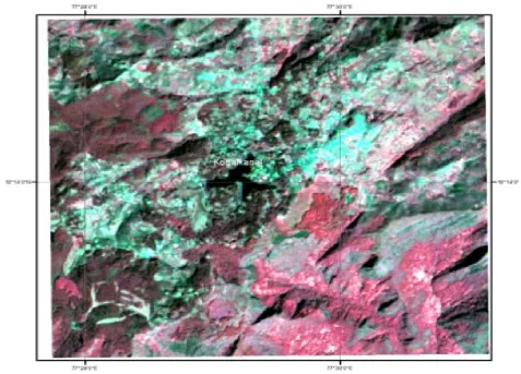
Figure 1. False Colour Composite (FCC) of Kodaikanal study area
Table 1. Landuse/Land cover distribution in Kodaikanal (2006 & 2011)
2011 Urban Crop
Land
Fallow Plantation Pond/ Lake
Forest Deciduos
Barren/ Wasteland
Forest Evergreen
Forest Plantation
Forest Scrub
Total
Urban 2.45 0.05 0.01 1.92 0.01 1.61 0.92 0 0.01 0 6.98
Crop Land 0.02 2.36 0.72 0.01 0 0.02 0 0 0.01 0 3.14
Fallow 0 0.02 0.01 0 0 0 0 0 0 0 0.03
Plantation 0 0 0.01 2.21 0 0 0.01 0 0 0 2.23
Pond/Lake 0 0 0 0 0.02 0 0 0 0 0 0.02
Forest Deciduos 0.04 0 0 0.01 0 1.57 0 0 0 0 1.98
Barren/Wasteland 0 0 0 0 0
Forest Evergreen 0 0 0 0 0 0 0 0.56 0 0 0.56
Forest Plantation 0.01 0 0 0.01 0 0.05 0 0 0.47 0.01 4.78
Forest Scrub 0 0 0 0 0 0 0 0 0.01 0.47 0.48
[image:4.595.50.546.224.719.2]Total 2.87 2.43 0.75 4.16 0.21 3.25 0.93 0.56 4.73 0.48 20.38
Figure 2. Landuse/Landcover map of Kodaikanla (2006)
The water bodies cover 1% and the barren area is converted in to built-up area. The forest classes also showed a decrease of 10% area and the present forest covers 38% of the study area. The decreased classes in the agriculture and forest are converted in to built-up area which clearly shows the population increase.
Acknowledgement
The author thanks the University Grant Commission-Major Research Project scheme (File No. 40 – 353/2011 (SR)) for funding support.
Conclusion
Information from satellite remote sensing can play a useful role in understanding the nature of changes in land cover/use, where they are occurring, and projecting possible or likely future changes. Such information is essential to planning for development and preserving our natural resources and environment, and is needed by urban planners and citizens.
[image:5.595.70.535.58.492.2]Satellite remote sensing approaches provide a cost-effective alternative when more information is needed, but budgets are declining. Our continuing work includes adding satellite imagery from other acquisition times, before and after the dates reported here, and classifications to the temporal series. The purpose of this study was to detect vegetation change using supervised and unsupervised change detection approaches. Future work with more satellite images and ground truth data may help to map the land cover changes with maximum level of accuracy. Kodaikanal is a famous Tourism place in south India the major source of income is through tourism. The major land use in Kodaikanal Taluk is forests. But the land under forest cover has experienced a declining trend in the past five years due to urban development. Here forest land converted to Agricultural land, Built up, and Harvested land due to this changes we lost our natural ecosystem a biodiversity also. The increase in agricultural land is a welcoming trend. But empirical observation reveals that due to increase in cost of cultivation, problems due to shortage of labor, supply of low quality adulterated fertilizers and price fluctuation in the
Figure 3. Landuse/Landcover map of Kodaikanla (2011)
market the farmers prefer to sell their land to property promoters. Hence there is a risk of decline in the extent of land under agriculture in the near future. The increase in the area under built up lands may lead to a lot of environmental and ecological problems. The study was successfully able to detect vegetation change and concluded that the area of the urban has increased whereas the area of crop land and plantation has been decreased within the period 2006-2010. To sum up it could be stated that Kodaikanal Taluk is one of the biodiversity zones of the country is under the threat of environmental and ecological problems due to improper management. Ground truth observations were also performed to check the accuracy of the classification. The results indicate that there was a significant increasing trend in built up land and decreasing trend in agricultural land. But now a day’s urbanization is a major problem in the area, because the agricultural labourer’s area goes and searches the job for tertiary activities. For reason attraction of Technology, no interest in involve the agricultural activities, shortage of source of water facilities, climatic change and low income. People have exchange form agricultural land to settlement because the demand of settlement in the study area. They also occupy the dry water bodies for their settlements, transport facilities and industrial development. The industrial and settlement waste material are putting in water bodies. This is the important one for decrease water bodies.
REFERENCES
Anderson R. James, Ernest E. Hardy, John T. Roach, and Richard E. Witmer. 1976. “A Land Use and Land Cover Classification System for Use with Remote Sensor Data”,
Geological Survey Professional Paper. pp 964.
Bisht, B.S. and Kothyari, B.P. 2001. Land covers change analysis of Garur Ganga watershed using GIS/ Remote Sensing Technique I. Ind. Soc. Remote Sensing., 29(3): 165-174.
Jenson, J.R. 1986. Introductory Digital Image Processing, Prentice Hall, NewJersey, Pp. 1836-1838.
Kachhwala, T.S. 1985. Temporal monitoring of forest land for change detection and forest cover mapping through satellite remote sensing. In: Proceedings of the 6th Asian Conf. on
Remote Sensing. Hyderabad, pp 77–83.
Luong, P.T. 1993. The detection of land use/ land cover changes using remote sensing and GIS in Vietnam, Asian
Pacific Remote Sensing Journal, Vol. 5, No. 2, Pp.63-66
Raghavswamy, V. 1994. Remote sensing for urban planning and management. In: Space Technology and Geography, Eds. Gautam, N.C., Raghavswamy, V., Nagaraja, R., NRSA Publishers, and Hyderabad, India, pp.34-36
Robert Pontius, 2013, Land use and Land cover changes in climate changes, The encyclopedia of Earth.,Article
154143.
Thomas R. Loveland. and Rezaul Mahmood. 2014. A Design for a Sustained Assessment of Climate Forcing and Feedbacks Related to Land Use and Land Cover Change.
Bulletin of the American Meteorological Society., 95:10,
1563-1572.
Uma Maheswari. R et al. 2015. Monitoring changes in land use/ land cover using multi temporal/sensor satellite data (a case study in palani). International Journal of Recent
Scientific Research Vol. 6, Issue, 2, pp.2867-2870,
February, 2015.
Ward D. S. , Mahowald N. M. and S. Kloster 2014. Potential climate forcing of land use and land cover change Atmos.
Chem. Phys., 14: 12701-12724.
15974 Uma Maheswari et al. Changes detection in land use land cover pattern using remote sensing and Gis in Kodaikanal town, Dindigul district