IMPROVEMENT OF QUALITY OF LIFE
USING REMOTE SENSING AND GIS
TECHNIQUES
PRASHANT PERSAI
Department of Civil Engineering, Maulana Azad National Institute of Technology, Bhopal – 462003, Madhya Pradesh, India
SUNIL KUMAR KATIYAR
Department of Civil Engineering, Maulana Azad National Institute of Technology, Bhopal – 462003, Madhya Pradesh, India
Abstract
Geographic Information System (GIS) and Remote Sensing (RS) Technology will improve the Quality of life in the city. The numbers of people living in the cities are main source of strength of the state. The settlements are worldwide rapidly increasing day by day due to fast growth of residents in the country and resultant the unmanaged information at city to village level.
The latest GIS and RS Technology makes possible to link all necessary information that is difficult to associate through any other technology. The power of a GIS and RS comes from the ability to relate different information from various sources in a spatial context. This technology will be a major hub of information that provides the latest information and updates to the citizens to make or take decisions.
The objective of this research is to explore the possibility of Improvement of the Quality of Life using latest available web based Remote Sensing and GIS Technology for the efficient development and planning of the state.
Keywords: Web based GIS; Remote Sensing Technology 1. Introduction
Urban planning is basically resource generation, resource development and resources management exercise. The prime requirements of urban planning process are the supply of information to planners or citizens, for preparation and implementation of plans to finalize the strategies. Hence, surprising that an effective urban planning has demanded and occupied a prime place on the nation’s agenda for development and implementation of plans to evolve the following research objectives:
Development of spatial information for citizens and planner of the state
The ultimate goal is to, Accessible and automate all government/ non government related information to all the citizens of the state
In the present scenario, the databases available with government/non government agencies are in conventional form. Extraction of the relevant information from the cumbersome database is very difficult and time-consuming process. Impact of current process increases the cost of the ongoing and future development projects. Considering these facts main pain areas are:
a) Traditional information viz; documents and maps etc. are in hard copy formats b) Integration of all maps and documents
c) Wide gap between the ground reality and paper maps d) Updation is expensive and difficult
e) Quick decision making is difficult, as data is not computerized
The numerous issues, related to citizen’s quality of life due to changes generally observed in land use and land covers patterns, needs to identify and resolved for the better development of the state.
The continuous research work is being carried out worldwide to address the issue of improvement of the quality of life in urban area. The Geographic Information Systems/GIS becoming very crucial in the governance [9]. Geographic Information systems (GIS) provide the platform for integration and processing of multi-sector Geosciences data in order to accurately predict results of different planning options [10]. E-governance is defined as the use of Information and communications technology (ICT) by different actors of the society with the aim to improve their access to information [14]. The GIS technique is very useful to assess the impact of conflicts on land use for urban physical infrastructure [12]. In the whole world the need of the spatial data has been increasing and much more people want to reach the spatial data via internet. At this point, the importance of spatial data for e-government projects is indisputable [13].
In this regard, recent research proposes GIS and Remote Sensing based e-governance system establishment in the city upto village level for improvement of the quality of life.
2. Data resources
Following input data are required for the successful execution and implementation of the Remote Sensing and GIS based system in the state:
Topographic maps, Cadastral maps, Municipal maps, Registration of Deeds, All government related Documents etc.
High resolution satellite data Secondary data or attribute data Network Connectivity LAN / WAN etc.
Desktop and Web based GIS and Remote Sensing Applications etc. 3. Methodology
In preliminary phase, we need to understand requirements, solutions, goals, objectives, costs and benefits, for citizens of the state. This research providing base line description against which project direction and status can be judged online. This research will also provide an outline for future framework and can be used to minimize the impact of future changes. Initially, needs to understand existing system and various agencies data for the development of understanding for successful implementation of project.
3.1Preservation of data
All government related data like; topographic maps, cadastral maps, municipal maps, registry of deeds and other government related data should be preserve because these are very precious and informative data for citizens and respective departments. Scanning, Map Registration, and data conversions are only options that we have for data preservation.
3.2. Image analysis
The high-resolution satellite data should be used to get better output. High-resolution satellite data should be free from cloud cover. The various image enhancement techniques should be applied after reviewing the quality of the digital data to increase the interpretability of the satellite data. Satellite Data should be geo-registered using Survey of India (SOI) topographic maps or DGPS/GPS survey data etc. The minimum layers/Maps should be generated during the digitization from satellite data and other maps like; Base map, Land Parcel Map, Land Use Land Cover Map, Drainage map, Road Network and Coastal Layer etc.
3.3 Creation of attribute data, data integration and GIS creation
Attribute creation activity should be undertaken simultaneously during the creation of the GIS database or layers as desired. All labels (text) should be stored in database for future usages purposes. All features should have unique identification number, so that future analysis could be done easily.
All departmental non-spatial data should be integrated with appropriate features, which should be provided by respective departments in .xls format or other specific/required format. All non-spatial data should be linked with spatial data (geo-referenced and digitized data) using unique ids fundamental.
3.4 Regular updation of data at all levels (state/district/city/village etc.)
Regular updations are main source or hub of current information’s for finalization of new master plans and deciding policies. There are possibilities to divide khasra / plot etc. in two or many parts using latest updated information. This is one example shows the need for updation of stored data. It is very necessary process to maintain and store up-to-date information for citizens at all levels.
3.5 Infrastructure development
geographic information system workstations, including digitizers, digitization software’s, plotters, printers and microcomputers etc. should be established at all levels for data entry and updaiton work.
3.6 Data storage and online publication
All data should be stored in one server at central location with backup servers. All respective locations in cities and states should be connected with central locations. Data should be available for common person for sharing of basic information’s. Data should be published online, but highly confidential data should have proper user authentications privileges. Internet Explorer should be used as the front-end browser for display of the spatial data.
3.7 Data security
To maintain the security from the illegal manipulations of data, the authorized user should be created, using high-end data security System. Various users at deferent levels like Administrator and Operator etc. should be created. They should have proper privileges for access of data from remote locations. Internet login session, Username, Password and departments name etc. should be inquired, before login / access of database.
4. Results and Conclusions
Remote Sensing and GIS based techniques will much more benefited and enhance the life of common man. Current era, Quality of life basically depends upon modern Technology and Process. On the other hand we can say it is depend upon interaction between citizens and government. Citizens’ Quality of Life will improve, if all government related services will provide at One-Stop-Shop at affordable costs, to meet the basic needs of a common man and policy maker.
Various key issues we have to target to improve Quality of Life in the state. To avoid delay to get information through tedious process;
Needs to develop a vision and policy Needs to identify resources
Needs to build and promote infrastructure Needs to develop guidelines and standards Needs to building of human capabilities
Needs of development of legal framework and empowerment Needs to Encouragement of citizen’s participation etc.
For the improvement of Quality of Life in the state, needs to do planning and analyze the requirement of the common man and also needs to finalization of business process. Various specific modules need to design, develop and implement for public users. All state and central level agencies should be connected through services providers. Single database should be generated at particular place using latest available technology. Common man should be able to get all information through mobile, phone, home PCs or through integrated service center like cyber café and kiosks etc.
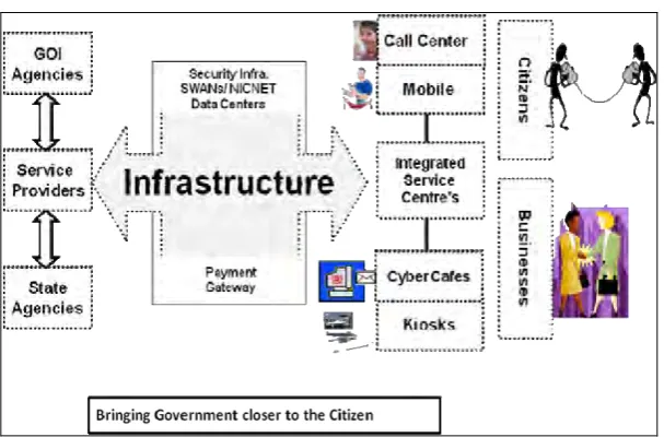
Complete Integrated Solution
Figure 1, Indicating general process to bring out government closer to the common citizens. At central location main database server with backup servers should be established for the storage of data. District levels, State levels and Panchayat levels server should be connected from main server through LAN/WAN technology. All data should be published on Internet for the common users or citizens. From security point of view common man should able to view information but they should not have privileges to delete or modify information’s, only authenticated users can delete or modify the information.
GIS / MIS based integrated system should be developed for citizens, government and corporate world. Mainly government could achieve social objective like finalization of law and public policy, trust, privacy, and develop transparency in government system. Corporate mainly could share return / risk and improve investment process etc., better services will definitely improve the life of citizens. This system would improve economic development; encourage accountability, transparency and greater awareness up to village level in the state. GIS based data would be benefited to common and departmental user.
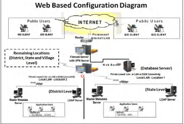
Figure 2: Shows web based configuration architect
It would create transparency, accessibility and accountability in Government Departments. It would also benefited for public as well as departmental authenticate users to take online decisions. The figure 2 indicating Web based configuration projection process up to village level. Various modules for specify purposes like; Road Information System, Land Records Information System, Flood Management System, Data Management System, MIS Data Management System, Forestry Management System, Water Management System, Business Management System, Online Data Storage System, Online Transport Management System, Vehicle Tracking System, Pollution Control System etc. should be developed to improve the quality of life of the common citizens. These modules should have capability of solve user’s queries on selected areas and it should also have capability to generate reports, charts and graphs for various statistical analysis purposes. The figure 3 indicating, following benefits that has been identified for the research purposes only:
Establishment of paper less system, Management and preservation of all valuable departmental data for Supply of all necessary information on Internet
Promotion of e-Governance system and Business Process in the state
Proper utilization of Land for various purposes like; residential, commercial, industrial, institutional, recreation, transportation, agricultural & allied etc.
Detailed plans for traffic and transportation for Route network inventory management and Traffic monitoring purposes
Fleet Infrastructure planning and management Housing and Slum improvement / development Environmental Improvements and protections Development of master plan and zonal plan etc.
Online report, graphs and charts generation for various analysis purposes
Control of corruption due to minimum interaction of government officials and process Online development of policy, guidelines, standards and finalization of vision Online monitoring of progress and its impact
Online building human capabilities and development of empowerment for the Legal framework finalization
Online generation of revenue etc.
These are limited benefits identified for the research purposes only.
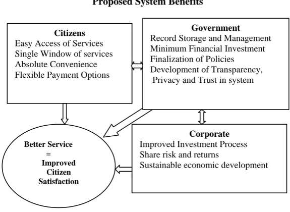
Proposed System Benefits
Figure 3: Shows benefits of system
References
[1] Thomas, M. Lillesand, Ralph, W. Kiefer, “Introduction to visual image interpretation”, pp. 261, Second edition. [2] T. Chang, Kang, “Introduction to geographic information system”, Idaho, pp. 59-61.
[3] Moha, E.A. (2006), GIS and Internet GIS technologies impact and challenges in land administration, GIS Development. http://www.gisdevelopment.net/
[4] Mishra, S., (2006). People’s data to people’s advantages GIS way, GIS Development. http://www.gisdevelopment.net/ [5] Raghavendran, S., GIS for intelligent cities of the future, GIS Development. http://www.gisdevelopment.net/
[6] Shah, B., (2004) GIS in town planning, GIS Development”, December http://www.gisdevelopment.net/magazine/index.htm [7] Babu, N.M., Implementing internet GIS with Java based client/server environment, Map Asia 2003, http://www.gisdevelopment.net/ [8] Martinez, J.A., The integration of GIS into policy making through intra-urban indicators, case study rosario (Argentina),
http://www.gisdevelopment.net/
[9] Imairi Eitiveni, Dana Indra Sensuse (2012), “Implementation of Tile Based Geographic Information System in Indonesia E-Government”, IJCSI International Journal of Computer Science Issues, Vol. 9, Issue 5, pp. 156-163.
[10] Chukwuocha C., Akajiaku and AC Ngozi Chukwuocha (2014), Geographic information system planning and monitoring best practices for West Africa, African Journal of Environmental Science and Technology, Vol. 8(1), pp. 31-40.
[11] Amarsaikhan, D., B. Chinbat,. M. Ganzorig,. V. Battsenge,. G. Bulgan1,. B. Nergui,. E. Egshiglen and R. Gantuya (2011). Applications of remote sensing (RS) and geographical information system (GIS) for urban land use change study in Ulaanbaatar City, Mongolia, Journal of Geography and Regional Planning Vol. 4(8), pp. 471-481.
[12] A. Ayanlade, O. I. Orinmogunje (2011), Assessing conflict impacts on urban physical infrastructure: A GIS approach, International Journal of the Physical Sciences Vol. 6(33), pp. 7567 – 7573.
[13] Guler Yalcin (2011), Geo-metadata in spatial data infrastructure and e-governance, African Journal of Business Management Vol. 5(12), pp. 4650-4656.
[14] Wilfred Uronu Lameck (2011), The role of e-governance in facilitating information needs in higher learning institutions: The case of Mzumbe University in Morogoro, Tanzania, Journal of Public Administration and Policy Research, Vol. 3(6).
[15] A. Michael Nwachukwu, Aslan Aslan, I Maureen, Nwachukwu, “Application of Geographic Information System (GIS) in sustainable groundwater development, Imo River Basin Nigeria”, pp. 310-320, International Journal of Water Resources and Environmental Engineering, Vol. 5(6), pp. 184-187.
Citizens Easy Access of Services Single Window of services Absolute Convenience Flexible Payment Options
Corporate Improved Investment Process Share risk and returns
Sustainable economic development
Better Service =
Improved Citizen Satisfaction