VANETs AND ITS RELATED ISSUES: AN EXTENSIVE
SURVEY
1JATAU ISAAC KATUKA, 2MUHAMMAD SHAFIE ABD. LATIFF
Department of Computer Science, Faculty of Computing, Universiti Teknologi Malaysia, Skudai, 81310,
Johor Darul Takzim, Malaysia.
2Assoc. Prof., Department of Computer Science, Faculty of Computing, Universiti Teknologi Malaysia.
E-mail: [email protected], [email protected]
ABSTRACT
Vehicular Ad hoc Networks (VANETs) is a type of ad hoc network whereby its nodes are represented by vehicles. It originated from the desire to ensure drivers comfort and safety in road transportation so as to reduce the risk of accidents on the roads. VANETs have some unique features that make it different from MANETs in terms of characteristics, architecture, applications and challenges. This paper presents an extensive survey on VANETs and issues that are common so as provide necessary information and insight to developers and researchers in this field of research. The paper begins with ad hoc networks and ends with tools for VANETs simulation.
KeyWords: Wireless Access in Vehicular Environments, Mobile Ad hoc Networks, Flying Ad hoc Networks, Intelligent Transport Service, Vehicular Ad hoc Networks, Routing.
1 INTRODUCTION
VANETs emerged from the desire to encourage the growing range in wireless products which are used currently vehicles [20]. Such products include remote keyless entry devices, mobile telephones, laptops, and personal digital assistants (PDAs). As mobile networks and wireless devices become more and more valuable, the demand for V2I or V2V communication will definitely continue to develop
[20]. [19] states that VANETs are often employed
in a wide range of applications such as safety and non-safety; enable value added applications like traffic management, automated toll payment, vehicular safety, improved navigation, infotainment services such as having access to the internet and applications based on location such as locating fuel station, the nearest restaurant, or hotel. Over the previous couple of years, several research efforts in investigating numerous problems associated with V2V, and V2I have been witnessed which has to do with the important function they play in the ITSs (Intelligent Transportation Systems) evolution. Varieties of projects have been carried out on VANET by different industries, educational institutions, and governments across the world
within the past decade. This paper presents an extensive survey on VANETs and issues that are common so as provide necessary information and insight to developers and researchers in this field of research.
2 ADHOC NETWORKS
The rapid internet growth has made
to the next accessible nodes. Generally, ad hoc
networks can be classified into three (3) categories namely Mobile Ad hoc Network, Vehicular Ad hoc Network, and Flying Ad hoc Network. In all the categories, the network topology changes randomly
and frequently. [35] show that VANETs have
unique features which differentiate them from other types of ad hoc networks.
2.1 Mobile Ad hoc Networks
MANETs are effectively used in disaster
recovery, and battle fields where the
communication between network hosts are carried out via packet radios and routes are mostly multi-hop [4; 25]. One among the challenging issues in mobile ad-hoc network is routing. Previous protocols for MANETs can typically be classified into re-active and pro-active protocols. Facts have shown that, such protocols have some inherent weaknesses. These drawbacks includes: established protocols are restricted to given scenarios, thus, it does not do well in all scenarios; no adequate work has been carried out to evaluate other techniques of similar types with respect to their performances.
Moreover, [4] proposed scheme focus on routing
without considering their effects on some other routing related problems. MANETs are wireless multi-hop networks that are self organizing, whereby every mobile node participates in the
process of communication. [54] assumes that every
mobile nodes that participates in the process of communication act at the same time as both end devices and routers.
To overcome the issue of routing, it entails a demanding task of efficiently developing a routing protocol. In order to achieve a certain level of routing operation for MANETs, lots of routing algorithms have been developed. Routing is generally used in establishing and maintaining the
routes from the source to destination [67]. Every
node are mobile, hence topology frequently changes. Routing protocols thus, play a crucial function in ad hoc network communications. Routing protocols in MANET are divided into the following categories:
a) Proactive protocols: In this protocol, each
and every node within the network keeps a routing table of packets of data that are
periodically broadcasted. The routes
between the source and destination are calculated at a regular time intervals before the route that will connect the source node
and destination node. A source node sends information to a known destination by examining the routing table to obtain a match for the destination. Wireless
Routing Protocol (WRP) [60], etc. are
proactive protocol examples.
b) Reactive (On-demand) protocols: The
routes in these protocols are established only when the originating source node desire to send the information to a given destination, in order to reduce control packets overhead. Ad-Hoc On-Demand
Distance-Vector Routing Protocol
(AODV) [53], Location-Aided Routing
Protocol (LAR) [32], Temporally-Ordered
Routing algorithm (TORA) [51], Dynamic
source Routing Protocol (DSR) [28], are
examples of reactive routing.
c) Hybrid protocols: This protocol combines
both reactive and proactive routing techniques to route information from source to the desired destination. ZRP (Zone Routing Protocol) is an example of hybrid routing protocol.
2.2 Vehicular Ad hoc Networks
Recently, the number of cars is increasing by day. Additionally, the increase case of fatalities is as a result of the increased numbers of private transport. Exploiting dedicated short
range communication (DSRC), VANET
ensures that moving vehicles communicate wirelessly with each other. DSRC is originally comply with IEEE 802.11a standard and is improved to 802.11p to reduce operation overhead; hence, the entire groups of 1609 standards were standardized under IEEE and are referred as WAVE. Using WAVE technology, a vehicle can communicate with fixed infrastructure that is located by the road, which can be termed as road side unit (RSU) (also known as V2I) or communicate with other vehicles directly creating V2V communication
[26; 46; 49]. These communications enable mobile nodes to exchange various types of information, for instance, safety information that can prevent accident, or traffic. Providing safety information to alert driver on time is the aim behind sharing and distributing this information.
tools, and protocols for VANET. Many
challenges are faced by them and they try to deal with these problems. Security and privacy
problem are addressed by [21]. [35] concentrate
on routing protocols for VANET to obtain good communication time and thus, minimize bandwidth consumption of the network. Categories of routing in VANET are also addressed by [37] and the concept is associated to each of these protocols.
A lot of research activities have been highlighted by several conferences and research
journals associated to VANETs [33; 56; 70]. In
addition to traffic services and safety, VANETs also can offer some entertainment services which include downloading or uploading of information, electronic advertisements, and lots of different on-demand services. The speedy growth in information technologies and
wireless communications are completely
changing several aspects of our lifestyle. One area of application that is expected to benefit immensely from this development is vehicular safety.
In VANETs, vehicles that are situated within a particular region form a cluster. Every cluster is dedicated with RSU. When a cluster is being set up, vehicles of the cluster can communicate between one another and with the cluster's RSU. It is also possible for inter-cluster communication between vehicles belonging to adjacent clusters. Cars sharing the same interest or belonging to the same organization can form a cluster where they can communicate with one another and share information, which is another interesting application of VANETs. Despite the
numerous interesting applications that
VANETs provides, routing at the intersection has always been an issue. Several researchers
[35; 38; 48] argue that MANETs routing protocols cannot be directly implemented in VANETs.
2.3 Flying Ad hoc Networks
Due to the fast technological developments on communication, sensor, and electronic technologies, it is feasible to provide Unmanned Aerial Vehicle that can fly independently or are often remotely controlled without conveying any person. Due to their ease of installation, flexibility, versatility, and comparatively little operational costs, the use of UAVs guarantees new methods for civilian and
military applications, for instance border
surveillance of border, search and destroy
operations [18], managing wildfire [5], wind
estimation [10], relay for ad hoc networks [27],
disaster observation [42], traffic observation [58]
and remote sensing [68]. For decades, single-UAV
has been in used, instead of creating and managing a large UAV. The use of clusters of single UAVs is of great advantages. However, one single UAV is restricted in terms of capability and hence, efficient collaboration and management of multiple UAV might produce a system which is more powerful than the ability of only a single UAV. Below are the benefits of multi-UAV systems:
a) Cost: It is cheaper in acquiring and
maintaining small UAVs than large UAV
[8].
b) Survivability: It importance cannot be over
emphasized. If the UAV stops working properly in a mission controlled by one UAV, implies that the mission cannot continue. But, when one UAV goes off in the process of a mission in multi-UAV system, it will survive the mission using the other UAVs.
c) Scalability: Multi-UAV systems widens
operational scalability with ease, however, the use of large UAV allows restricted
amount of coverage [45].
d) Small radar cross-section: Rather than
using a huge radar cross-section, it is advisable to use multi-UAV systems because, it create very small amount of radar cross-sections, and it’s applications
are seen in the military environment [65].
e) Speed-up: Missions are often completed
faster in a multi-UAVs environment [72].
FANETs are a form of ad hoc network like
VANETs and MANETs. However, certain
variations exist between FANETs and the other ad hoc networks in existence as follows:
a) Mobility of nodes in FANET is far higher
b) Topology changes frequently due to high
mobility in FANETs, than the topology of a VANET or MANET.
c) The distances from one FANET nodes to
the other are farther apart than VANETs node or MANETs node.
d) Multi-UAV systems might embody
differing kinds of sensors, and each of the sensing elements might need completely different data delivery methods.
3 CHARACTERISTICS OF VANETs
VANET has grown into an important research area over the past decades. VANET has its own distinctive features compared with MANETs as follows:
a) High Computational Ability: Owing to the
fact that the nodes in VANETs are vehicles, they are supplied with adequate sensors and resources for computation such as advanced antenna technology, global position system (GPS), processors, and large memory capacity. Computational capabilities of node are increased by these resources, which assist in achieving reliable communication, obtaining correct message concerning its current position,
direction and speed [47; 49].
b) Predictable Mobility: The mobility in
VANETs is different from MANETs in
whereby nodes in VANETs move
randomly, because cars are usually restricted by the topology of the road and layout, thus are required to obey traffic
lights, and road signs [7; 24; 35; 66]
resulting to their movements being predictable.
c) No Power Constraints: In VANETs, power
is not a serious issue as in MANETs, due to the fact that cars can supply power continuously to OBU through the use of long life battery [24; 47; 73].
d) Providing Safe Driving: This is achieved
by improving traveler satisfaction and improving traffic efficiency. The direct communications between mobile nodes are ensured by VANETs, hence enabling the usage of set of applications that require
direct communication between vehicles over the network. These applications offer warning information to passengers moving along the same direction concerning the urgency for swift hard breaking or about accidents, thus the driver needs to create a larger image of road topology ahead. Furthermore, VANETs can also improve traveler satisfaction and improve traffic efficiency by proving information such as shopping malls, gas station, weather,
traffic flow, and fast food [24].
e) Variable Network Density: This depends
on the density of traffic, which can be low, as in suburban traffic or high during traffic jam [66; 73].
f) Large Network Size: The size of the
network might be large in VANETs such as highways, urban centre, and when entering large cities [66; 73].
g) Swift Distortions in the Topology of the
Network: Vehicles moving on the
highway, at a high speed, results to swift adjustment in the topology of the network. In addition, the information received can influence the behavior of the driver, as such results to changes in the topology of
the network [35; 66; 73].
4 VANET TAXONOMY FOR
COMMUNICATION PROTOCOLS
The applications in VANET require
communication between cars to facilitate
information circulation. Based on the
characteristics of VANET, the following are
VANET taxonomy for communication
protocols:
4.1 Defining and Naming Issues
connection of internet between service
providers and users. The task of routing is an issue due to high mobility of node. The destination of information might be a fixed location, like road side unit, or a mobile vehicle with known position. Geocasting is a geographically restricted type of limited broadcasting. Information is disseminated to every car that is on the road or in a given
geographical area. For example, the
dissemination of content that is based on files
being separated into multiple messages [34].
4.2 Dimension of Road
Several scenarios exist by which cars can travel on roads. Vehicles can travel on a highway without intersections. A road with two-direction with no intersections is referred to as one dimensional (1D). More generally, in urban regions, vehicles are placed in two dimensions (2D) where several intersections exist and a node may decide to change road on which it is moving. Intermediate scenarios also exist in which cars are constrained by roundabouts or junctions.
4.3 Neighborhood Knowledge
Some VANET protocols, forwarding
decisions are made by vehicles without neighbor knowledge. However, in other protocols, it becomes necessary for nodes to learn and know its neighbors. Node could be aware of speed, and position of neighboring nodes. Such location knowledge of neighbor
nodes becomes accessible during
communication between nodes.
4.4 Acknowledgments
Acknowledgements are used to tell a sending node that the message sent has successfully been received. Beacon acknowledgment is used when a vehicle explicitly acknowledge receiving a packet when the vehicle adds the message it received to its regular beacons. Passive (implicit) acknowledgement is used when a vehicle estimate based on the distance, the reception of a packet from the sender.
4.5 Starting Forwarder Selection
Ideally nodes are usually in a state of being idle with respect to packets that are broadcasted. During the state of being idle, either a packet is not received so it not possible to retransmit or retransmission is not necessary for example the acknowledgement of receipt of
packets by all known neighbor nodes. Otherwise, the question is how a node determines whether the retransmission of a packet is necessary to cover certain nodes. As such, the process of starting forwarder selection of neighbor nodes to forward packets is initiated, and a state of being active with respect to the packet. The simplest decision of a forwarder selection method is that a node is in an active state whenever a packet is received
[15]. Other alternative is to activate
immediately when the packet is received for the first time and do not consider any further
reception of the same packet [59].
4.6 Compete to Retransmit
Nodes that are active are a candidate for retransmission, but are not in the act of retransmitting yet. Vehicles normally negotiate the process of retransmission with neighbors. Negotiation is frequently carried by Time to Live (TTL), and waiting for the expiration of TTL. Active nodes (‘winners’ of forwarder selection) can enter into the state of transmission following a MAC layer protocol. However, vehicles to respond at different times due to certain delays which are introduced by medium access protocols. When one vehicle starts retransmitting, other vehicles must wait for the transmission to complete before continuing. The DSRC standard proposed is based on 802.11 kind of competition whereby vehicles wait for specific number of slots before it retransmits.
4.7 Connectivity
This is very essential in VANETs because disconnections of nodes are frequent event even in
dense traffic [3]. In some protocol, nodes are
assumed to be always connected. However, performance of this protocol is greatly affected should disconnection occur. Hence, different communication algorithms offer solutions for disconnection of node by providing alternative schemes like the store-carry-forward.
4.8 Urgency
accident to incoming vehicles, it is still urgent (but
considered less urgent) to forward the position of the accident to emergency centers.
4.9 Message Contents
VANET communication protocols address
different types of message. It is classified into two 2. Full message is the first class referred to as the original message, which contains specific detail of information concerning the source and destination, such as the location of the source, location of
destination, and speed [50]. A message in the
second class might contain the forwarder ID so as to
guarantee reliable and fast delivery of message [59].
5 VANETs NEWORK ARCHITECTURE
With the large increase of vehicles on roads recently, driving has become more challenging and dangerous. Roads are filled up with vehicles, reasonable speeds and safety distance are rarely adhered to, and travelers frequently lack adequate
concentration. As such, leading automobile
producers decided to collectively work with government organizations to come out with solutions geared toward assisting travelers on high ways by anticipating dangerous scenario or refrain from severe traffic regions. Meanwhile, the main objective is clearly to enhance safety of car traffic, onboard amusement applications and traffic management solutions are also anticipated by the various bodies (CALM) and projects (CarTALK
2000 [57]; VICS4 [71]; FleetNet [16]; CarNet [44]).
The communication between V2V or between V2I is accomplished via wireless medium known as
WAVE (Wireless Access in Vehicular
Environments) [1].
5.1 On Board Unit (OBU)
OBU is mounted usually on-board of a node and is a WAVE device used for exchange of information with other OBUs or with Road Side Unit (RSUs). Normally, OBU is composed of a user interface, memory used for storing and retrieving message, a processor, an interface which serves as a link to different OBUs, wireless device for short communication range based on IEEE 802.11p. OBU connects to different OBUs or to the RSU via a wireless channel which is based on the IEEE 802.11p and it ensures the exchange of messages with RSUs or with different OBUs. The major tasks of OBU includes ad hoc and geographical routing, wireless radio access, information security, IP
mobility, reliable message transfer, and network
congestion control [49].
5.2 Application Unit (AU)
AUs are devices equipped inside the vehicle which uses the services supplied by the provider by exploiting OBU capabilities. AU can be a PDA to connect to the Internet or a device dedicated for safety applications. A wired or wireless connection is used to connect the AU to the OBU and may be kept in one physical unit with the OBU. The difference between OBU and the AU is logical.
5.3 Road Side Unit (RSU)
RSUs are WAVE devices that are fixed in locations like near parking areas or junctions or on the road segment. The RSU is furnished with device that is dedicated for communication of short range based on the radio technology such as IEEE 802.11p, and for the aim of communication within the network infrastructure. RSU may be furnished also with different network devices as shown in Figures 1 to Figure 3. The major functions related to RSU according to C.C. Communication Consortium are:
a) The range of ad hoc network
communication is extended by
redistributing the messages to different OBUs and by relaying messages to different RSUs so as to transmit it to different OBUs.
b) It runs applications for safety such as work
zone or accident warning, a low bridge warning, using V2I communication and it serves as a source of information.
c) It provides OBUs with Internet
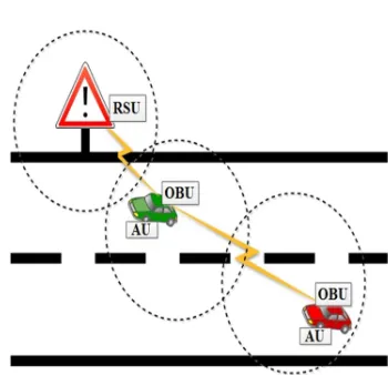
Figure 1: The ad hoc network communication range is extended to other OBUs by redistributing the messages
[image:7.595.91.485.83.696.2][12]
[image:7.595.105.280.393.562.2]Figure 2: RSU runs applications for safety [12]
Figure 3: RSU provides OBUs with internet connections [12]
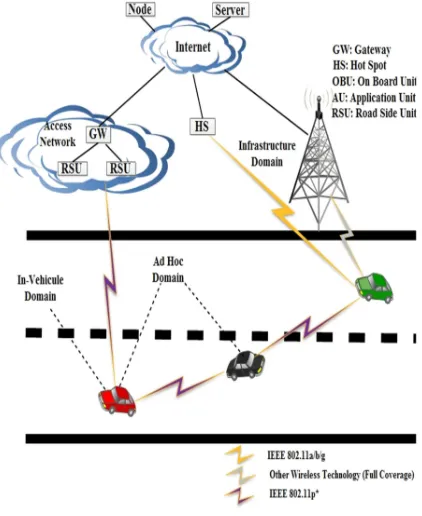
6 VANET COMMUNICATION DOMAINS
As shown in Figure 4, there are three types of domains for vehicles to communicate with the RSU and the infrastructure:
a) In-vehicle domain: Includes an OBU with one or several AUs. A wired or wireless connection is used to connect the AU to the OBU and may be kept in one physical unit with the OBU.
OBU provides a channel for
communication to the AUs so as to
execute some application by
exploiting OBU communication
capabilities [12; 14; 49].
b) Ad hoc domain: Consists of cars that are equipped with RSU and OBUs. Two types of communications are
obtainable as follows [14; 49]:
• Due to its ability to enhance traffic
safety on road, and efficient driving
[39], vehicles uses the OBU to
communicate with one another, which
enables distributed pattern of
• The RSU is used by vehicles so as to
enhance communication range by sending and receiving information from a vehicle to another vehicle.
C) Infrastructural domain: RSU connects to
the Internet, enabling the network
[image:8.595.90.301.288.546.2]infrastructure to be accessed by the OBU. As such, for the AUs to be connected to the Internet, it must be registered with the OBU.
Figure 4: Communication Domains in VANETs
[49]
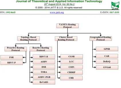
7 ROUTING PROTOCOLS IN VANETs
For decades, VANET has been studied and
widely investigated [20; 63; 74]. Because
VANETs are unique form of adhoc networks, most of protocols in MANETs have been examined and tested in VANETs. VANETs routing algorithms are usually categorized as
topology-based and address-based which
demands that every participating node is given a special address. Hence, a specific mechanism is needed to give special addresses to cars nevertheless; it is not a guarantee to avoid
duplicate addresses in the network [43]. Hence,
[image:9.595.92.514.72.380.2]
Figure 5:Classification of VANETs routing protocols
7.1 Topology-Based Routing
Packet forwarding is carried out by using links’ information that exists in the network.
Topology-based techniques [48; 53] take
advantage of the information from obtainable network links for packet transmission and each node should keep information up-to-date with the routing table. In order to select a path from source to destination, topology-based routing uses links information formerly collected by the vehicle (table-driven or proactive) or required when needed (on-demand or reactive). Topology-Based routing is divided into reactive (on-demand) and proactive (table-driven) routing.
a) Proactive routing
Irrespective of communication requests, the next forwarding node routing information is preserved in the network background. In order to maintain the routes or link states, control packets are continuously broadcasted and flooded between vehicles though some of the routes created will never be used in the network. Within a node, a routing table is therefore created where every entry in the table of routing points to the direction of next hop toward the desired destination. Proactive
routing protocols do not require route discovery because path are usually maintained in the background that leads to the destination node and is accessible at all times upon lookup. In spite of its nice feature for ensuring low latency, the process of maintaining the paths that are unused occupies to a large extent the available bandwidth, particularly in VANETs environment where mobility is high. Examples of Proactive protocol include
Fisheye State Routing (FSR) [23; 52], and
Road-Based using Vehicular Traffic-Proactive
(RBVT-P) [48].
b) Reactive routing
In reactive routing protocols, the routes are open only when nodes want to exchange information with another node. Reactive routing maintains only the currently used routes, thus the network burden is reduced. Typically reactive protocols use route discovery in which the network is flooded with query packets in search of a route. The route discovery phase is completed when a path is established. Examples of Reactive protocol include Road-Based using Vehicular
Traffic-Reactive (RBVT-R) [48], Reactive
Traffic Aware Routin Strategy (ReTARS)
AODV (Ad hoc On Demand Distance Vector)
[53], and TORA (Temporally Ordered
Routing Algorithm) [51].
7.2 Clustered Based Routing Protocol (CBRP)
Vehicles that are close to each other make up a cluster in this type of routing protocols. The inter and intra-cluster management function is the responsibility of the cluster-head in each cluster. The Intra-cluster nodes exploit direct links to exchange information with each other, while cluster headers are responsible to ensure communication in inter-cluster. In CBRPs, the creation of clusters and cluster-head selection is a crucial issue. As a result of high mobility in VANET, the formation of dynamic cluster is an obvious
process. K-Hop Cluster-Based Routing
Protocol [11] improves CBRP with
improvement in mobility as well as number of nodes. CBR (Cluster Based Routing protocol)
[40], CBDRP (Cluster-Based Directional
Routing Protocol) [61], are the examples of
CBRP.
7.3 Geographical Routing Protocols
Geographical routing generally refers to as position-based routing offers an adaptable routing elucidation for wireless networks. Ultimately, it is ordinarily a scalable routing technique intended for wireless networks, whereby the nodes will generate neighborhood routing selections that make the use of position information. In geographic routing, nearby neighbors within a region exchange position information is acquired through GPS (Global Positioning System) or any other
location perseverance mechanism [69].
Geographic routing protocols are networking mechanism that distributes information to vehicles that are within a specified destination region. Therefore, routing protocols ensure information dissemination efficiently over several hops until each and every vehicle within the destination region receives this
information [62]. Each car checks and
examines if re-transmission is needed and implements it properly in an efficient manner. In this routing concept, the addresses of individual nodes are associated with their corresponding geographical position that is often used by sending vehicle to move data packets to the destination vehicle. Geographic routing possesses the advantage that should be much more adaptable as a consequence of
lesser desire for routing information. Thus its efficiency as well as adaptability make a decent choice for routing within multi-hop
wireless networks [69].
Basically, geographical routing algorithms require knowledge about the location of the vehicles participating in the network. Thus, a sender can easily ask for the location of the receiver using a location service to forward the packet to the destination using different mechanisms. These however, include other related techniques such as greedy forwarding,
hierarchical forwarding and Restricted
Directional Flooding (RDF).
The most common method of geographical routing is through greedy forwarding packets for the neighbors that are geographically nearest to the destination. Despite the fact that the greedy technique is almost effective, packets might get routed to where no next hop neighbor exists which is closer to the destination and the void circumstance arise. Thus, the void problem occurs when there is no any node in the direction of the destination. Ultimately, several geographical routing
techniques [17; 31; 35] are recommended
with assorted forwarding techniques to select neighbors as the next-hop node. One example includes Greedy Perimeter Stateless Routing
(GPSR) [29].
8 VANET RELATED ISSUES AND CHALLENGES
There are many challenges that arise as a result of running VANETs as an ad hoc communication among vehicles moving in a road environment. Hence, it is important to highlight the major issues in VANET, and from the technical perspectives, the key challenges are as follows:
a) Routing protocol: Developing a routing
protocol which will efficiently ensure packet delivery within little time frame with few packets that are dropped is considered as a
serious issue in VANETs [9; 21; 37; 75].
b) Small effective diameter: This results to
weak connectivity during the
communication between nodes due to
VANETs small effective network
completely maintain global network
topology for a node [22].
c) Signal fading: This is an issue in VANETs
which occur as a result of obstacles (or objects) which are placed between two vehicles that are communicating; such obstacles can be static objects such as buildings or moving objects such as other vehicles. The impact of these obstacles is the increase in signal fading and stopping the signal from getting to its destination
[21].
d) Bandwidth limitations: In VANET, there
is no central coordinator that is assigned with the responsibility of contention handling and bandwidth management. As such, efficient utilization of available bandwidth is very essential. Due to limited range in VANETs bandwidth frequency, the probability of channel congestion occurrence is high especially in high density environment.
e) Security and privacy: To maintain a
balance between privacy and security is a big challenge in VANETs; it is important for the receiver to receive trustworthy message from its source. However, the privacy of the source can be violated by
the trusted information [21].
f) Connectivity: The topology in VANETs
changes rapidly due to high mobility,
which results to frequent network
disconnectivity. As such, the duration of
time required to prolong the
communication life of the link must be
adequate. To accomplish this, the
transmission power is increased; however, throughput degradation may occur.
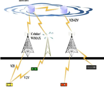
9 COMMUNICATION TECHNOLOGIES IN VANETs
Presently, a lot of wireless technologies are available, which provide radio interface for vehicles
to communicate with the RSUs (V2I
communication) or each other (V2V
communication). Such wireless technologies are aimed to enhance the comfort of driver and passenger, improve traffic efficiency, and to improve road safety. Some wireless access technologies include:
a) Cellular systems: To reuse the available
limited frequency is the idea behind cellular system [55]. Global system for
mobile (GSM) communication is described as a second generation (2G), provides data
at the rate of 9.6Kbps [49]. GSM is seen to
be a cellular system standard. GSM uses both FDMA (frequency division multiple access) and TDMA (time division multiple access) schemes. In GSM, the available frequency bands are 935–960 MHz and 890– 915 MHz for downlink (the connection from a larger network to a smaller network (or a device) is referred to as downlink) and uplink (the connection from a smaller network (or a device) to a network that is larger is referred to as an uplink) respectively. GPRS (General packet radio service) referred to 2.5G is a
derived from GSM [24]. EDGE (Enhanced
Data rates for GSM Evolution) is derived
from GPRS [46].
b) Combined wireless technologies: A set of
wireless technologies like GPRS/GSM, are incorporated to Continuous Air interface for Long and Medium range (CALM), and
are adapted to IEEE 802.11p [24]. Figure
6, shows that in addition to existing V2V, V2I, mixed mode (V2V and V2I), such technology creates new atmosphere for vehicular networking scenarios, which is
made possible by the technologies
mentioned above.
c) Worldwide interoperability for microwave
access (WiMAX): WiMAX or IEEE 802.16e is an improvement to the original WiMAX, which IEEE endorsed in the year 2004. Wide range of transmission and high data rate to ensure high quality of service (QoS) are made possible by IEEE 802.16e, thereby providing a suitable environment for those applications that needs these features for example VoIP, multimedia, etc. WiMAX uses Multiple-Input and Multiple-Output (MIMO) to achieve a high data rate [6].
d) WLAN/WiFi: Wireless access to ensure
V2I or V2V communication can be provided by WLAN/WiFi. In order to
provide wireless connectivity, IEEE
provides the same data rate as IEEE
802.11a but runs at a frequency of 2.4 GHz
[49]. Another standard is IEEE 802.11b, it
provides a data rate of 11 Mbps and runs at
a frequency of 2.4 GHz [46].
e) DSRC/WAVE: DSRC originated from
[image:12.595.76.294.303.495.2]IEEE 802.11a. DSRC is improved for operations with low overhead in the DSRC spectrum and it is based on IEEE 802.11p
[26; 46]. DSRC/WAVE provides a data rate of more than 27 Mbps, with 300m 1000m communication range, and moving
at a speed of 200Kmph [24; 66].
Figure 6: Wi-Fi, WiMAX , Cellular, and Combined DSRC in a single form [49]
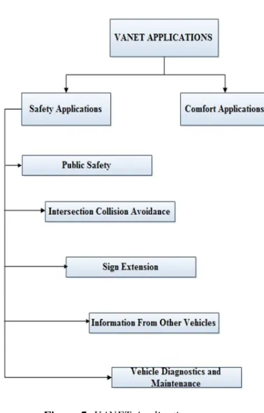
10 VANET APPLICATIONS
Large number of applications can be developed due to V2V and V2I communications and can support wide range of information which is beneficial to travelers and drivers. Network interface and on-board devices can be incorporated, such as different types of GPS receivers and sensors enable nodes to receive, process, and distribute information about its environment and itself to other nearby nodes. As such, road safety and passenger’s
comfort are improved [24; 66]. Figure 7 shows the
classification of VANET applications into their purpose as follows:
a) Comfort applications: It is known as
non-safety applications and the objective of this
application is to enhance passenger’s comfort and to improve traffic efficiency. These applications make available to drivers with the location of petrol station, nearest restaurant, traffic information,
nearest hotel, weather information, [24;
46; 66] etc.
b) Safety applications: In order to avoid
accidents and enhance road safety, these
applications use the communication
between V2I or V2V; the aim is to provide a good environment and to save lives. Figure 7, categorized safety applications as follows:
Public safety: The aim of public safety
applications is to assist drivers in case of accident and to assist search and rescue teams to provide services efficiently and minimize their travel time. The range of communication used by this application is 300 to 1000m and the frequency is 1Hz
which depends on V2I, V2V or both [49].
For example, SOS services, Emergency vehicle signal pre-emption, etc.
Collision avoidance at Intersection: Many
road accidents can be avoided by
improving collision avoidance at
intersection which based on V2I
communication. Information are received from vehicles approaching intersection, processed and analyzed by sensors at the infrastructure. After analysis on the data is completed, if the probability of an accident occurring, then warning signal are sent to vehicles arriving at the intersection warning them of the possibility of accident for them to take necessary and appropriate actions. For example, warning about violating traffic signal, etc.
Sign extension: This is to warn drivers that
are not paying attention to road signs which are stationed by the road side so as to avert road accidents. For example, curve speed warning, work zone warning, etc.
Information from other vehicles: It
frequency is 2 to 50Hz [49]. For example,
cooperative forward collision warning, etc.
Diagnostics and maintenance of vehicle:
[image:13.595.105.294.240.536.2]This is used to send warning notification to vehicles with the objective of reminding the driver on the need for the vehicle to receive timely maintenance and about safety defects. For example, Just-in-time repair notification, etc.
Figure 7: VANET Applications
11 NETWORK SIMULATORS
It enables researchers to observe how the behavior of the network would be under varied conditions. Hence, researchers can meet their demands by customizing the simulator. It is relatively cheaper and faster to use network simulators compared to conventional way of setting up an entire network consisting of routers, multiple networked computers, and data links. Thus, researchers can test scenarios at ease that might be too expensive or too difficult to emulate when real hardware are used, particularly in VANETs environment.
a) NS-2 [13] is a discrete event simulator
which was developed at University of California by group of researchers on VINT project. Monarch research group extended the simulator at Carnegie Mellon University by incorporating node mobility, radio network interfaces, IEEE 802.11 MAC (Medium Access Control) protocol, and a radio propagation model with physical layer.
b) JiST/SWANS [2] is a discrete event simulator that runs over Java virtual machine. SWANS is a wireless network simulator that is scalable which is built on JiST platform. JiST simulation uses Java, standard virtual machine to run the simulations, and is compiled using Java compiler. When writing simulations, it does not require domain-specific language and must not be filled with system calls
during runtime simulations. Rather,
existing virtual machine are converted by JiST into simulation platform, whereby byte-code level is embedded in the simulation time semantics.
c) GloMoSim [41] is both a wired and wireless network environment simulator that is scalable. GloMoSim is designed using the concept of layered approach which is similar to the OSI model. Rapid integration of different models are possibly developed by different researchers at different layers because, between separate simulation layers, APIs are used.
12 CONCLUSION
This paper surveys extensively all VANET routing protocols such as topology-based routing which performs packet forwarding by exploiting the links’ information that is obtained in the network. Topology-based techniques take advantage from the information of obtainable network links for packet transmission and each node should keep up-to-date information with the routing table. In order to select a path from source to destination, topology-based routing uses links information formerly collected by the vehicle (table-driven or proactive) or required when needed (on-demand or reactive); cluster based routing where vehicles that are close to each other make up a cluster in this type of routing
protocols. The inter and intra-cluster
head in each cluster. The Intra-cluster nodes
exploit direct links to exchange information with each other, while cluster headers are responsible to ensure communication in inter-cluster. In CBRPs, the creation of clusters and cluster-head selection is a crucial issue. As a result of high mobility in VANET, the formation of dynamic cluster is an obvious process. Cluster-Based Routing is an example of on-demand source routing whereby it tries to reduce control overhead by partitioning clusters into nodes in route discovery; and geographical routing also referred to as position-based routing which offers an adaptable routing elucidation for wireless networks. Ultimately, it is ordinarily a scalable routing technique intended for wireless networks, whereby the nodes will generate neighborhood routing selections that make the use of position information. Current issues of routing in VANETs are centered on resolving intersection issues in an urban vehicular environment. There are many challenges that arise as a result of running VANETs in order to provide an enhancement to driver behavior, so as to minimize the rate of fatalities caused by accidents. Hence, major issues in VANET are highlighted from the technical perspectives such as bandwidth limitations, signal fading, connectivity, small effective diameter, security and privacy, and routing protocol.
REFERENCES:
[1] 1. IEEE Trial-use Standard for Wireless Access in Vehicular Environments (wave)-Resource Manager. IEEE Std 1609.1-2006. . 2006.
[2] 2. SWANS ++, SWANS++ Extensions to the
Scalable Wireless Ad hoc Network Simulator, 2011.
[3] 3. Abuelela, M., Olariu, S., and Stojmenovic,
I. OPERA: Opportunistic Packet Relaying in Disconnected Vehicular Ad Hoc Networks. in 5th IEEE International Conference on Mobile Ad Hoc and Sensor Systems MASS. 2008. Atlanta, USA.
[4] 4. Bakht, H., Some Applications of Mobile
Ad-hoc Network. in Computing Unplugged Magazine, 2004: p. 1.
[5] 5. Barrado, C., Messeguer, R., López, J.,
Pastor, E., Santamaria, E., Royo, P., Wildfire
Monitoring Using a Mixed Air-Ground Mobile
Network. IEEE Pervasive Computing 2010.
9(4): p. 24–32.
[6] 6. Bhakthavathsalam, R., and Nayak, S.,
Operational Inferences on VANETs in 802.16e and 802.11p with Improved Performance by Congestion Alert, in In IEEE Consumer communications and networking conference (CCNC) 2011. p. 467–471.
[7] 7. Blum, J., Eskandarian, A., Hoffman, L.,
Challenges of Intervehicle Ad hoc Networks.
IEEE Transactions on Intelligent
Transportation Systems, 2004. 5(4): p. 347–
351.
[8] 8. Chao, H., Cao, Y., Chen, Y. Autopilots for
Small Fixed-wing Unmanned Air Vehicles: A Survey. in In International Conference on Mechatronics and Automation, (ICMA). 2007.
[9] 9. Chen W, G.R., Kwon T, Lee J, and Hsu,
Y., A Survey and Challenges in Routing and Data Dissemination in Vehicular Ad hoc Networks. Wireless Communications and
Mobile Computing, 2011. 11(7): p. 787-795.
[10]10. Cho, A., Kim, J., Lee, S., and Kee, C. ,
Wind Estimation and Airspeed Calibration Using a UAV With a Single-antenna GPS Receiver and Pitot Tube. IEEE Transactions on
Aerospace and Electronic Systems 2011. 4: p.
109–117.
[11]11. Chunhua, Z., and Cheng, T. A K-hop
Passive Cluster Based Routing Protocol for MANET. in 5th International Conference on Wireless Communications, Networking and Mobile Computing, WiCom 2009.
[12]12. C. C. Communication Consortium, Car 2
Car Communication Consortium Manifesto.
[13]13. Fall, K., and Varadhan, K., The NS-2 Note
and Documents. The VINT Project, UC Beckerly, LBL, USC/ISI, and XEROX PARC., 2000.
[14]14. Festag, A., Noecker, G., Strassberger, M.,
Lubke, A., Bochow, B., Torrent-Moreno, M., Schnaufer, S., Eigner, R., Catrinescu, C., and
Kunisch, J. Now-Network on Wheels: Project
Objectives, Technology and Achievements. in In Proceedings of the 5th International Workshop on Intelligent Transportation. 2008.
[15]15. Fracchia, R., and Meo, M., Analysis and
Design of Warning Delivery Service in Inter-vehicular Networks. IEEE Transactions on
Mobile Computing, 2008. 8: p. 832-845.
[16]16. Franz, W., Eberhardt, R., and Luckenbach,
[17]17. Frey, H. Geographical Cluster Based
Multihop Ad hoc Network Routing with Guaranteed Delivery. in Mobile Adhoc and Sensor Systems Conference, 2005. IEEE International Conference on. 2005. Washington, DC.
[18]18. George, J., Sujit, P.B., and Sousa, J. ,
Search Strategies for Multiple UAV Search and Destroy Missions. Journal of Intelligent and
Robotics Systems 2011. 61: p. 355-367.
[19]19. Gerlach, M., Full Paper: Assessing and
Improving Privacy in VANETs. www.network-on-wheels.de/downloads/escar2006gerlach.pdf (accessed: Nov. 29, 2013). 2006.
[20]20. Harsch, C., Festag, A., and Papadimitratos,
P., Secure Position-Based Routing for VANETs, in In Proceedings of IEEE 66th vehicular technology conference, VTC-2007, Fall 2007: Baltimore. p. 26–30.
[21]21. Hartenstein, H., Laberteaux, K., A Tutorial
Survey on Vehicular Ad hoc Networks. IEEE
Communications Magazine, 2008. 46(6): p.
164–171.
[22]22. Hartenstein H., a.L., K. , VANET Vehicular
Applications and Inter-Networking
Technologies. Wiley Online Library, 2009.
[23]23. Iwata, A., Chiang, C. C., Pei, G., Gerla,
M., and Chen, T. W., Scalable Routing
Strategies for Ad hoc Wireless Networks. IEEE
JSAC, 1999. 17(8): p. 1369–1379.
[24]24. Jakubiak, J., and Koucheryavy, Y. State of
the Art and Research Challenges for VANETs. in In 5th IEEE Consumer communications and networking conference. CCNC 2008. 2008.
[25]25. Jatau, I.K., Yahaya, S. D., Bako, S. S.,
TCP ISSUES IN MOBILE ADHOC
NETWORKS: Challenges and Solutions. International Journal of Modern Engineering
Research (IJMER), 2013. 3(1): p. 439-446.
[26]26. Jiang, D., Taliwal, V., Meier, A.,
Holfelder, W., and Herrtwich, R., Design of 5.9
Ghz DSRC-Based Vehicular Safety
Communication. IEEE Wireless
Communications, 2006. 13(5): p. 36-43.
[27]27. Jiang, F., Swindlehurst, A. L., Dynamic
UAV Relay Positioning for the ground-to-air uplink. In IEEE Globecom Workshops, 2010.
[28]28. Johnson, D.B., and Maltz, D. A. , Dynamic
Source Routing in Ad hoc Wireless Networks. 1996, Kluwer Academy Publishers.
[29]29. Karp, B., and Kung, H, T. GPSR: Greedy
Perimeter Stateless Routing for Wireless Networks. in Sixth ACM International Conference on Mobile Computing and Networking. 2000. Boston, Massachusetts.
[30]30. Khokhar, R.H., Ngadi, M. A., Latiff, M.
S., and Amin, M. A., Reactive Traffic-Aware
Routing Strategy for Urban Vehicular Environments. International Journal of Ad hoc and Ubiquitous Computing (IJAHUC), 2011.
10(3): p. 149 - 163.
[31]31. Kihl, M., Sichitiu, M., Ekeroth, T., and
Rozenberg, M. , Reliable Geographical
Multicast routing in Vehicular Ad-hoc Networks. . Wired/Wireless Internet Communications, 2007: p. 315-325.
[32]32. Ko, Y., and Vaidya, N., Location-Aided
Routing (LAR) in Mobile Ad-Hoc Networks.
Wireless Networks, 2000. 6(4): p. 307–321.
[33]33. Krishnamurthy, P. Information
Dissemination and Information Assurance in Vehicular Networks: A Survey. in in A Conference Poster in iConferenc 08. 2008. Los Angeles.
[34]34. Leontiadis, I., Costa, P., and Mascolo, C.,
Persistent Content-Based Information Dissemination in Hybrid Vehicular Networks, in IEEE International Conference Pervasive Computing and Communications PerCom2009.
[35]35. Li, F., and Wang, Y., Routing in Vehicular
Ad hoc Networks: A Survey, in Vehicular Technology Magazine, IEEE2007. p. 12-22. [36]36. Li, T., Li, Y. and Liao, J. A
Conntention-Based Routing Protocol for Vehicular Ad hoc Networks in City Environments. in In IEEE International Conference on Distributed Computing Systems Workshops, ICDCS Workshops' 09 2009.
[37]37. Lin, Y., Chen, Y., and Lee, S., Routing
Protocols in Vehicular Ad hoc Networks: A Survey and Future Perspectives. Journal of Information Science and Engineering, 2010.
26(3): p. 913–932.
[38]38. Lochert, C., Mauve, M., Fussler, H., and
Hartenstein, H. , Geographic Routing in City
Scenarios. In SIGMOBILE Mob. Comput. Commun. Rev. New York, NY, USA: ACM, 2005. 9: p. 69-72.
[39]39. Luo, J., and Hubaux, J. P., A Survey of
Inter-Vehicle Communication, 2004, Technical
Report, School of Computer and
Communication Sciences. EPFL, Lausanne, Switzerland.
[40]40. luo, Y., Zhang, W., and Hu., Y. A New
[41]41. Martin, J., GloMoSim: Global Mobile
Information Systems Simulation Library. UCLA Parallel Computing Laboratory, 2001.
[42]42. Maza, I., Caballero, F., Capitán, J.,
Martínez-De-Dios, J. R., Ollero, A.,
Experimental Results in Multi-UAV Coordination for Disaster Management and Civil Security Applications. Journal of
Intelligent and Robotics Systems, 2011. 61
(1-4): p. 563–585.
[43]43. Mohandas, B., and Liscano, R. IP Address
Configuration in VANET Using Centralized
DHCP. in In Proceedings of 33rd IEEE
conference on local computer networks. 2008. Montreal, Canada.
[44]44. Morris, R., Jannotti, J., Kaashoek, F., Li,
J., and Decouto, D. CarNet: A Scalable Ad hoc
Wireless Network System. in In Proceedings of the 9th ACM SIGOPS European Workshop. 2000. Kolding, Denmark.
[45]45. Morse, B.S., Engh, C. H., Goodrich, M. A.
UAV Video Coverage Quality Maps and Prioritized Indexing for Wilderness Search and Rescue. in In Proceedings of the 5th ACM/IEEE International Conference on Human–Robot Interaction (HRI). 2010. Piscataway, NJ, USA.
[46]46. Moustafa, H., Zhang, Y., Vehicular
Networks: Techniques, Standards, and Applications. 2009: CRC Press.
[47]47. Nekovee, M., Sensor networks on the
road: the promises and challenges of vehicular ad hoc networks and grids. In: Workshop on ubiquitous computing and e-Research, 2005.
[48]48. Nzouonta, J.R., N., Wang, G., and Borcea,
C., VANET Routing on City Roads Using Real-Time Vehicular Traffic Information. Vehicular Technology, IEEE Transactions on 2009.
58(7): p. 3609-3626.
[49]49. Olariu, S., and Weigle, M. C., Vehicular
networks: From Theory to Practice First Edition ed. 2009: Chapman & Hall/CRC.
[50]50. Osafune, T., Lin, L., and Lenardi, M.
Multi-Hop Vehicular Broadcast (MHVB). in 6th International conference on ITS Telecommunications. 2006. Chengdu.
[51]51. Park, V., and Corson, S.,
Temporally-Ordered Routing Algorithm (TORA) Version 1 Functional Specification. IETF Internet draft, work in progress, draft-ietf-manet-tora-spec-04.txt, 2001.
[52]52. Pei, G., Gerla, M., and Chen, T. W.
Fisheye State Routing: A Routing Scheme for Ad Hoc Wireless Networks. in In Proceedings,
ICC. 2000. New Orleans, LA.
[53]53. Perkins, C., and Royer, E., Ad hoc
On-Demand Distance Vector Routing. In Mobile Computing Systems and Applications, 1999: p. 90-100.
[54]54. Qabajeh, L., Kiah, L. and Qabajeh, M., A
Qualitative Comparison of Position-Based Routing Protocols for Ad-Hoc Networks. International Journal of Computer Science and
Network Security (IJCSNS), 2009. 9: p.
131-140.
[55]55. Rahnema, M., Overview of the GSM
System and Protocol Architecture. IEEE
Communications Magazine, 1993. 31(4): p.
92–100.
[56]56. Raya, M., Papadimitratos, P., and Hubaux,
J. P., Securing Vehicular Communications.
IEEE Wireless Communications, 2006. 13: p.
8-15.
[57]57. Reichardt, D., Miglietta, M., Moretti, L.,
Morsink, P., and Schulz, W., CarTALK 2000 –
Safe and Comfortable Driving Based Upon Inter-Vehicle-Communication. In. Proceedings of the IEEE IV, 2002.
[58]58. Semsch, E., Jakob, M., Pavlícek, D.,
Pechoucek, M. Autonomous UAV Surveillance
in Complex Urban Environments. in In Web Intelligence. 2009.
[59]59. Shin, D., Yoo, H., and Kim, D. Emergency
Message Dissemination with Ack-Overhearing Based Retransmission. in First International Conference on Ubiquitous and Future Networks. 2009. Hong Kong.
[60]60. Shree, M., and Garcia-Luna-Aceves, J. J.,
An Efficient Routing Protocol for Wireless Networks. Mobile Networks and Applications,
1996. 1(2): p. 183-197.
[61]61. Song, T., Xia, W., Song, T., and Shen, L. A
Cluster-Based Directional Routing Protocol in VANET. in In 12th IEEE International Conference on Communication Technology (ICCT) 2010. Nanjing.
[62]62. Stojmenovic, I., Seddigh, M., and Zunic,
J., Dominating Sets and Neighbor Elimination-Based Broadcasting Algorithms in Wireless Networks. IEEE Transactions on Parallel and
Distributed Systems, 2002. 13: p. 14-25.
[63]63. Sun, S., Kim, J., Jung, Y., and Kim, K.,
Zone-Based Greedy Perimeter Stateless Routing for VANET. In Proceedings of
international conference on information
networking, ICOIN, 2009: p. 1-3.
[64]64. Sun, Z., Wang, P., Vuran, M. C.,
Wireless Sensor Networks. Ad hoc Networks
2011. 9(3): p. 468–477.
[65]65. To, L., Bati, A., Hilliard, D. Radar
Cross-section Measurements of Small Unmanned Air Vehicle Systems in Non-cooperative Field Environments,. in In 3rd European Conference on Antennas and Propagation, (EuCAP), IEEE,
2009. 2009.
[66]66. Toor, Y., Muhlethaler, P., and Laouiti, A.,
Vehicle Ad hoc Networks: Applications and
Related Technical Issues. IEEE
Communications Surveys Tutorials, 2008.
10(3): p. 77-88.
[67]67. Trung, H.a.B., W., Location-Aided
Multipath Routing Method for Mobile Ad- Hoc Networks, in First IEEE International
conference on Communication and
Electronics,2006: Henoi. p. 7-12.
[68]68. Xiang, H., Tian, L., Development of a
Low-cost Agricultural Remote Sensing System Based on an Autonomous Unmanned Aerial Vehicle. Biosystems Engineering, 2011. 108(2): p. 174–190.
[69]69. Xiao, Y., Guan, Y., Chen, W., Shen, C. C.,
and Cimini, L. J. Location-aware Cooperative
Routing in Multihop Wireless Networks. . in In Wireless Communications and Networking Conference (WCNC). 2011.
[70]70. Xiaodong, L., Rongxing, L., Chenxi, Z.,
Haojin, Z., Pin-Han, H., and Xuemin, S., Security in Vehicular Ad hoc Networks. IEEE
Communications Magazine, 2008. 46: p. 88-95.
[71]71. Yamada, S., The strategy and deployment
for VICS. IEEE Communications, 1996.
34(10): p. 94–97.
[72]72. Yanmaz, E., Costanzo, C., Bettstetter, C.,
Elmenreich, W. A Discrete Stochastic Process
for Coverage Analysis of Autonomous UAV Networks. in In Proceedings of IEEE Globecom-WiUAV, IEEE, 2010. 2010.
[73]73. Yousefi, S., Mousavi, M. S., and Fathy, M.
Vehicular ad hoc networks (vanets): challenges and perspectives. in In Proceedings of the 6th
international conference on ITS
telecommunications. 2006
[74]74. Yu, D., and Ko, Y.-B. FFRDV:
Fastest-Ferry Routing in DTN-Enabled Vehicular Ad hoc Networks. in In Proceedings of 11th international conference on advanced communication technology. 2009.
[75]75. Zhang, M., and Wolff, R. , Roting
Protocols in Vehicular Ad hoc Networks in Rural Areas. Communication Magazine, IEEE,