Localization of Nodes: A New Challenge for Wireless
Sensor Networks
Manik Gupta
M.TechChitkara University, Baddi Himachal Pradesh
Nitika Sharma
M.TechChitkara University, Baddi Himachal Pradesh
ABSTRACT
With the widespread involvement of low cost, small sized sensor nodes in the wireless sensor networks (WISENETs) technology to support variety of collaborative applications such as monitoring and surveillance for civilian as well as military purposes; location aware computing for such nodes is really becoming an important challenge. Localization also plays a vital role in ubiquitous environments with computing potentials in targeting nodes for their security as well as navigation. Since inclusion of GPS receiver in a sensor node becomes too expensive, hence for locating sensor nodes in wireless sensor networks a small number of sink nodes are used that know their location whereas other nodes estimate their location based on the transmission and receiving energy of the message which they send to the sink node. This paper provides an overview of the existing localization solutions with their comprehensive performance metrics in wireless sensor networks and attempt to classify them broadly in terms of their usage area which can be indoor or outdoor or both.
General Terms
Wireless Sensor Network (WSN), Sensor Nodes (SN), WISENETs, Localization.
1.
INTRODUCTION
During couple of years, Wireless Sensor Network plays a vital role in research area. These networks have an extremely crucial role in many pervasive technologies. One reason may be they consists of large no. of sensor nodes having multiple preset functionalities such as sensing and processing. Wireless Senor Network (WSN) deals with various aspects such as security, mobility, routing, energy efficiency and localization. These networks are tremendously being used to perform various monitoring tasks such as battlefield surveillance, target tracking, environment monitoring, search, rescue and perimeter security etc. Many such tasks require location information of the Sensor Nodes (SN). Thus, node localization has become inherently one of the major challenges over recent years.
Although WSN deployment is static most of the time but there are many applications that requires mobility of nodes. Mobility enables sensor nodes to target and track moving phenomenon such as earth bound vehicles, chemical clouds etc [8].Mobility plays a vital role in the execution of application. Since sensor nodes are deployed dynamically in a hostile area without any fixed infrastructure or may change their position during run-time, thus it becomes difficult to perform continuous surveillance whereas in case if static WSN once the node positions are determined they are
unlikely to change, thus no such problem occurs. Thus localization has gained much attention in recent years and is considered to be one of the fundamental challenges in mobile wireless sensor networks also. A mobile wireless sensor network is an application of wireless sensor network.
Applications of WISENET with localization
requirements:
Military:
Military is one of the biggest promoter of wireless sensor technology. A WSN is usually deployed in a hostile area without any fixed infrastructure. Therefore it becomes very difficult to perform continuous surveillance; hence network can suffers from various attacks. In many such applications localization can help to develop various defense and detection algorithms which protect the networks from various malicious attacks.Environmental:
Wireless Sensor Network have many environmental applications such as pollution monitoring, landslide detection etc. described below:-
Pollution monitoring
:
WSN are usually deployed in various cities where localization can help to monitor the concentration of dangerous gases for citizens.-
Landslide Detection:
Localization can help to detect the slight movement of soil and changes in various parameters in wireless sensor networks.Underwater Applications
:
Underwater Wireless Sensor Networks supports a variety of applications such as oceanographic data collection, pollution monitoring, disaster prevention and assisted navigation. In many such applications sensed data can only be derived if the location of the sensor node is known. Thus localization helps in determining the position of the sensor nodes to fulfill various application objectives.Health Applications
: Localization can help in tracking and monitoring patients and doctors, drug administration and monitoring of human physiological data in hospitals.geographic routing which only require relative position of node. Moreover many places we go and stay are indoors and even a single building can contain multiple places especially in dense urban environment. Such applications require pin point information about the location. That is, different applications needs different granularity of location information. This paper provides an overview of various indoor, outdoor as well as hybrid techniques in reason of their numerous applications in wireless sensor networks.
2.
LOCALIZATION TECHNIQUES IN
WIRELESS SENSOR NETWORK
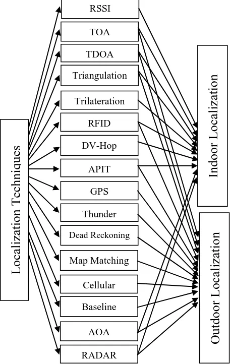
A large number of localization techniques can be implemented in enormous application areas primarily categorized into indoor and outdoor zones; though some may fit in both. Fig.1 categorizes all such techniques that can be implemented in WISENETs.
Fig.1: Categorization of localization techniques
Received Signal Strength Indicator (RSSI)
:
This is the most common indoor localization technique found in the wireless sensor network which is very useful in dense traffic scenario where interference is a major concern. RSSI measures the power of signals at the receiver and based on the known transmit power, the effective propagation loss can be calculated [6]. By using theoretical or empirical model signal strength can be translated into distance. RSSI is basically a measurement of the power present in a received radio signal. This method is commonly used by the RADAR or RF signals.
RF provides software access to the amplitude of the received signal therefore this method does not involve any hardware modifications. Thus this method is low cost and can be easily configured without any extra device.
Time of Arrival (TOA):
TOA [14] makes use of signal propagation time to obtain range information. A system needs to be synchronous to use TOA for range estimation .It demands high clock resolution to measure the accurate position. TOA can be measured using different signaling techniques such as Direct Sequence Spread Spectrum or Ultra wide Band measurements. TOA method can be applied to many different signals such as RF, infrared and ultrasound etc. Fig. 2 shows the measurement method in TOA which requires signals from at least three reference points; here in the figure X, Y, Z are three reference points; R1, R2, and R3 are their respective signal radius and C is the common point of signal intersection of X, Y and Z.
Fig. 2: Positioning Method for Measurement in Time of Arrival
GPS uses the TOA technique to calculate the range information. There are other algorithms for TOA such as closest neighbor that estimates the location of the received signal over a time period T, one commonly used among them is TDOA .Many WSN applications including monitoring and tracking users TOA to calculate the node positions thus, solves the problem of both indoor as well as outdoor localization.
Time Difference Of Arrival (TDOA)
:
TDOA [2] method provides more accuracy under line of sight conditions. TDOA transmits the Ultrasound and Radio signals at the same time to obtain the range information through which distance between node and source is calculated. This method can be applied to many different signals such as RF, ultrasound, acoustic etc. This technique requires special hardware i.e. ultrasonic channel which makes it expensive for wireless sensor networks. The traditional methods to compute TDOA uses correlation techniques and can be estimated from the cross correlation between the received signals at a pair of measuring units. Let, s(t) be the transmitted signal, the received signal at measuring unit n is rn(t). If rn(t) is corrupted by the noise non(t) and delayed by dn, then rn(t) = s(t−dn) + non(t). Similarly, the signal rm(t) = s(t−dm)+ nom(t), which arrives at measuring unit m, is delayed by dm and corrupted by the noise nom(t).Then the cross-correlation function of these signals is given by integrating the lag product of two received signals over a time period T.
Y
X
Z R2
R1
R3
Localization
Techniq
u
es
RSSI
TOA
TDOA
Triangulation
Trilateration
RFID
DV-Hop
APIT
GPS
Thunder
Dead Reckoning
Map Matching
Cellular Localization
Baseline Techniques
AOA
RADAR
Indoor Loca
lization
Outdoor L
oca
lizatio
n
[image:2.595.54.283.259.620.2]= 1/T (t) (t- )dt
The TDOA estimates the value that maximizes the range
difference i.e. TDOA solves the problem of indoor as well as outdoor localization for various civil as well as military surveillance applications.
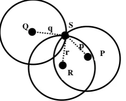
Trilateration:
It locates a node by calculating the intersection of three circles. Trilateration [12] involves gathering a number of tuples of the form (a, b, d) to calculate the object location where d represents the estimated distance providing the location reference form (a, b) and the sensor node. Fig 3. shows the positioning method for calculating the distance p, q and r corresponding to the node pairs (P, S), (Q, S) and (R, S) respectively.Fig. 3: Positioning Method for Measurement in Trilateration Technique
This is the most basic method used in wireless sensor network to calculate the node position. Trilateration can also be used for various indoor as well as outdoor applications including navigation and surveying to calculate the node distance.
Triangulation:
This method [13] uses the lateration or angulations for the determination of location of a sensor node. In this method, some nodes are called Anchor nodes and it is assumed that their location is known to them. These nodes broadcast their location information to all their neighboring nodes.
Fig. 4: Positioning Method for Measurement in Triangulation Technique
Angulation is the calculation of position information of an object by measuring its distance, d from multiple reference points, as in Fig. 4 given by:
d = /
The distance estimation can be based on time of arrival (TOA) or relative signal strength (RSSI).Angulation approach uses the Angle-of-Arrival (AOA) which estimates the angle at which signals are received to find the relative location of the sensor node. Triangulation serves as a basis for many geometry based routing, localization, segmentation and data storage and processing algorithms in wireless sensor network and can be used for indoor as well as outdoor environment.
Radio Frequency Identification (RFID
): RFID [9] enables tracking of people and objects. Data can be retrieved and stored on RFID tags enabling real timeidentification of users and devices. RFID provides coarse-grain location information .RFID are widely used for automatic identification and tracking .RFID systems are classified into two categories: monitoring and authorizing. In RFID monitoring systems, tags are permanently attached to the entities. Such networks provide the capability to check, monitor and authenticate which tags are present in the interrogation zone. In RFID authorizing systems tags are not permanently attached to the entities and hence the identity of the entity in possession of the RFID tag cannot be verified. RFID can be used in many applications like access management, tracking of goods and persons, toll collection and contactless payment to solve localization for indoor as well as outdoor environment.
DV-HOP:
This approach [4] uses the classical distance vector routing. In this technique, one anchor broadcasts a beacon to be flooded throughout the network containing anchor location with a hop count value initialized to zero. Each receiving node maintains the minimum hop count value per anchor of all beacons it receives. Through this mechanism, all nodes in the network gets the minimal hop count to every anchor node. This technique solves the problem of indoor localization for various civil as well as military applications.
Approximation Point - in - Triangulation
(APIT):
This approach [3] narrows down the possible area in which a target node resides. APIT requires a heterogeneous network of sensing device equipped with high power transmitters and location information known as anchors. Each node chooses three anchors from all audible anchors and tests whether it is inside the triangle formed by connecting theses three anchors. The advantage of APIT is its simplicity and ease of implementation but it requires a high range or longer range beacons to get a good position estimate. APIT solves the problem of indoor as well as outdoor localization for various applications such as healthcare, military as well as disaster management.
Global Positioning Systems (GPS):
GPS is the most common technique used in wireless sensor networks that solves the problem of outdoor environment for various applications such as disaster relief, vehicle tracking, robotics and military monitoring. GPS makes use set of satellites which offers three dimensional positioning with more accuracy. This method works well for wireless sensor network with node mobility. Each node is equipped with GPS receiver. But the Sensor Nodes equipped with GPS receivers makes it costly in terms of both hardware and power consumption.GPS works well when it has clear view of sky but fails its importance in the presence of dense forests, mountains that block the line-of-sight from GPS satellites [16]. Moreover the power consumption of GPS reduces the battery life of the sensor nodes which results in reducing the effective lifetime of entire network. A-GPS technique has been developed that overcome the conventional limitations of GPS.
Thunder:
Thunder technique reduces the complexities and power requirements from each node to a single powerful centralized device. This technique is more efficient and requires zero cost in terms of extra hardware node. The efficiency of thunder l
α β
P Q
R S
p q
[image:3.595.55.183.236.338.2]depends upon the ranging distance a single centralized device can support. One practical application how thunder works is as described: A helicopter equipped with powerful centralized device drops a large number of sensor nodes in a geographical area randomly. Then it flies to different locations and simultaneously broadcast the sound and sends a radio signal containing the location of helicopter. Sensors receiving radio signals can use the TDOA approach to compute their distance to helicopter, if a sensor gets three distances to the helicopter at three locations not in a line, trilateration method can be used to compute its 2D location. This technique solves the problem of outdoor localization in various applications such as military surveillance with low cost and higher accuracy.
Dead Reckoning:
This localization technique [7] is used mainly for target tracking that forms many other numerous applications such as failure of event detection, unexpected change in the mobile event’s direction etc. Dead Reckoning calculates the target’s present position by projecting its past positions and speed over elapsed time and known target’s path. The target is localized by the senor nodes, then these nodes sends the measured location coordinate to cluster head. The cluster head processes the information, timestamp it and then sends the information to the base station. Dead Reckoning also provides the functionality of error correction and error avoidance using position fix. This algorithm also solves the problem of outdoor localization for various military as well as commercial applications.
Map Matching:
Map Matching is an event detection mechanism that provides numerous of applications such as object tracking, disaster monitoring and habitat monitoring etc. and solves the problem of outdoor environment only. This mechanism is based on matching the contour maps of in-network sensory data distribution. This algorithm is simple SQL extension that allows users to specify common types of events as patterns in counter maps. Map matching approach for event detection is based on spatiotemporal patterns in sensor readings. This approach works with the assumption that the changes in senor reading with networks that are caused by an event usually exhibit some spatiotemporal patterns. This approach is more efficient in terms of hardware and effective cost.
Cellular Localization:
Cellular localization [15] provides coursed-grain position estimate and depends on the density of infrastructure nodes. This technique uses the global system of mobile or code division multiple access to estimate the location of outdoor clients. This system provides high accuracy in dense environment. Cellular Localization uses wide signal strength fingerprints to provide more accuracy which includes six strong GSM cells and 29 other GSM channels which are strong enough to be detected. This techniques provides outdoor localization for various applications such as battle damage assessment, battlefield surveillance etc.
Baseline Technique:
Baseline technique provides outdoor localization in various underwater applications. Based on the distance between the base stations, this technique is categorized in to three phases: Long Baseline, Short Baseline and Ultra Baseline.
Long Baseline System:
This system [10] is used when the distance between the base stations is long or similar to the distance between object and transponders. The distance usually ranges from 50m to 2000m. The baseline transponders are deployed and a geographical area and signal from object is sent. On receiving the signal, transponder sends a reply. The signal propagation time is then used to calculate the distance between the object and transponders. Long Baseline System provides more accuracy than short or ultra-baseline systems. This system provides outdoor localization in various underwater applications oceanographic data collection, military underwater surveillance and many ecological applications.
Short Baseline System
:Short Baseline Systems [11] provides localization for tracking underwater targets. These systems are mounted on floating platforms such as ships, boats etc and distance usually ranges from 20m to 50m. Short Baseline Systems uses trilateration to determine the position and round trip signal propagation time between transponders and target to compute the distance. The accuracy of Short Baseline System increases with increase in distance between baseline transponders. Short Baseline Systems have been use in Antarctica expeditions to track vehicles operating under the ice.
Ultra Baseline System
:Ultra Baseline System [11] consists of two elements: Transponder and Transceiver with an array of transducers that provides ultra-short baseline. The transceiver sends an acoustic pulse and when the transponder detects the pulse it replies with its own acoustic pulse. Then distance is computed using round trip propagation timing of transponder and transceiver pulse. This system uses phase differencing method to calculate angle to transponder. On obtaining the range and angle from transceiver to the transponder the position of object is calculated. Ultra Baseline System consumes less power than Long or Short Baseline Systems.
Angle-Of-Arrival (AOA):
Angle-Of-Arrival is defined as the angle between the propagation direction of an incident wave and some reference directions known as orientation [5]. AOA estimates the angle at which the signals are received and use geometric relationships to find the relative positions of sensor nodes. Fig. shows the positioning method for measurement in AOA, where X and Y are reference points representing two sensor nodes and 1 and 2 are two measured angles to derive the two-dimensional location of target C.
Fig. 5: Positioning method for measurement in Angle of Arrival
AOA measurements can be obtained using an antenna array on each sensor node or by detecting the angles between nodes. This technique is used in various wireless sensor applications such as controlling traffic in streets, tracking patients in hospitals and monitoring enemy forces in battlefield to know the positions of sensor nodes and solves the problem of indoor as well as outdoor environment.
2 1
C
RADAR:
This technique uses radio waves to determine the range, direction or speed of objects. A RADAR system includes transmitter that emit radio waves to determine directions. RADAR operates by recording and processing signal strength information at the multiple base stations positioned to provide overlapping coverage [1]. RADAR solves the problem of indoor as well as outdoor environment for various applications such as air traffic control, air defense systems, and marine radar to locate landmarks and other ships.
3.
PERFORMANCE METRICS:
To measure the performance of a positioning technique and considering the difference between the indoor and outdoor wireless geolocation we provide the following performance benchmark as described below:
Cost
: The cost of positioning system is an important factor that involves money, time, space, installation and the system’s administration needs together with capital cost such as infrastructure element. Measuring unit density is considered to be a space cost. Some positioning systems such as RFID, RADAR are completely energy passive. Thus energy is also considered to be an important factor. Installation and maintenance are related to time factor.Security
:
Secure localization is an important factor in wireless sensor network. The various security requirements for localization are listed below:Integrity
: The information provided by the source should not be altered before the sensor node can use it to discover the location.Authentication
: The provider has to be authenticated before accepting location related information.Non repudiation:
No communication party can deny the information exchange between the source and the sensor node.Privacy
: Location privacy is the important factor for security requirement. The source should only help the sensor node in determining its location.Precision:
Precision considers how consistently the system works. Precision is the distribution of distance error between the estimated location and true location. Cumulative Probability Function is used to measure the precision of a system and is described by the percentile format.Complexity:
Complexity of a system depends on the attributes such as hardware, software and operation factor. Location rate is an important factor of complexity. When the computation is performed on a central server, the positioning is calculated quickly due to sufficient power supply but in base of mobile unit side, effect of complexity is less.Scalability:
Scalability of a system depends upon he two factors: geography and density. Geographic scalability is related to the volume or area covered whereas density scalability is the number of units located per unit geographic
area per time period. Dimensional space of the system such as 2D and 3D are another measures of scalability.
Accuracy:
Accuracy ensures mean distance error as a performance metric, which is the average Euclidean distance between the estimated location and true location. The higher the accuracy, the better the system.4.
FUTURE TRENDS AND
CONCLUSION
Localization in wireless sensor networks has become a challenging factor for various military as well as commercial applications. Different applications demands different granularity of information. Localization has many important metrics as security, energy efficiency, robustness, accuracy and scalability etc. This paper presents a survey on various localization techniques in wireless sensor network. This paper presents a comprehensive overview of need of localization in wireless sensor network and various techniques used for localization based on different granularity of information. This paper also discusses the various requirements of localization needed in wireless sensor network.
There are several direction for future work in wireless sensor network. There is still need to be focused on techniques with more efficiency and inexpensive in terms of hardware and cost. In addition, there is much interest in localization in indoor and urban areas where obstacles cause multipath propagation and loss of line of sight. Thus additional work is needed to develop indoor, outdoor localization algorithms with more efficiency and accuracy.
5.
REFERENCES
[1] P. Bahl and V. Padmanabhan, "RADAR: An In-Building RF-Based User Location and Tracking System," Proceedings, vol. 2, pp. 775-784, 2000.
[2]Andreas Savvides, Chih-Chieh Han, Mani B. Strivastava. Dynamic fine-grained localization in Ad-Hoc networks of sensors.MobiCom, 2001.
[3] Tian He, Chengdu Huang, Brian M. Blum, John A. Stankovic, Tarek Abdelzaher. Range-free Localization Schemes for Large Scale Sensor Networks.MobiCom. 2003.
[4]Dragos Niculescu and Badri Nath. DV Based Positioning in Ad hoc Networks.Kluwer Journal of Telecommunication Systems, 2003.
[5]Dragos Niculescu and Badri Nath. Ad Hoc Positioning System (APS) Using AoA.IEEE InfoCom,2003.
[6] Eiman Elnahrawy, Xiaoyan Li and Richard P. Martin, “ The Limits of Localization Using Signal Strength: A Comparative Study, in Proceedings of IEEE SECON, pp. 406-414, Santa Clara,California, USA, October 2004.
[7] Fang, L., Antsaklis, P.J., Montestruque, L., Mcmickell, M.B., Lemmon, M., Sun, Y.,Fang, H., Koutroulis, I., Haenggi, M., Xie, M., Xie, X.: Design of a wireless assisted pedestrian dead reckoning system – the NavMote experience. In: IEEE Transactions on Instrumentation and Measurement, vol. 54(6), pp. 2342– 2358, 2005.
Workshop on Strategies for Energy Efficiency in Ad Hoc and Sensor Networks, 2005.
[9] R. Want. An introduction to RFID technology. IEEE Pervasive Computing, 5(1):25–33, January-March 2006. [10] Hydro, 2008a. Product survey - long baseline systems.
Hydro International http://www.hydro-international.com/productsurvey/id12LongBaselineSyste ms.html.
[11] Hydro, 2008b. Product survey - ultra short baseline systems. Hydro International http://www.hydro-international.com/productsurvey/id13- UltraShort Baseline Systems.html.
[12] Manolakis, D.: Efficient solution and performance analysis of 3-D position estimation by trilateration. IEEE
Transactions on Aerospace and Electronic Systems 32(4), 1239–1248, 1996.
[13] Esteves, J., Carvalho, A., Couto, C.: Generalized geometric triangulation algorithm for mobile robot absolute self-localization, 2003.
[14] Wang, X., Wang, Z., O’Dea, B.: A toa-based location algorithm reducing the errors due to non-line-of-sight (nlos) propagation. IEEE Transactions on Vehicular Technology 52(1), 112–116, 2003.
[15] Niculescu, D., Nath, B.: Dv based positioning in ad hoc networks. Journal of Telecommunication Systems 22, 267–280, 2003.