© 2016, IRJET ISO 9001:2008 Certified Journal
Page 340
ADVANCED ANTI ACCIDENTAL SOLUTION BY PRE ANALYZING,
TRACKING AND DETECTION OF SHIP USING
GPS (GLOBAL POSITIONING SYSTEM)
Priya Dhokne
1, Prof.S.B.Rothe
21
Priya Dhokne, PG student, Mtech VLSI, GHRIETW, (Nagpur) Maharashtra, India.
2
Prof.S.B.Rothe (Depart. of Electronics and Telecommunication), GHRIETW, (Nagpur) Maharashtra, India.
---***---Abstract -
The project is implemented and taken into consideration; we have effectively created an Advanced anti accidental solution by pre analyzing, tracking and detection of ship using GPS. This project helps us to minimize the ship accidents or in many cases it will be easier to take precautionary action against accident by identifying the ship such as temperature changes against cold and burning, fire catches in ship and ship alignment as vibration in the ship and final location about ship where ship is available in the sea. The purpose behind to create this project is that, the effective tracking of ship will be possible and we can able to know the status of ship i.e. location of ship , its alignment and available temperature which will help us to identify and sort out ship accidents, their causes and location finding of ship. In this project whatever status available on the ship; get read with the help of related sensors. This pre-analysis includes the status of the sensors that means if fire occurred in the ship thenthis information directly transmitted through transmitter and received at the receiver along with
their status similarly checked status of vibration in ship and misalignment of the ship. All relevant information of the ship along with tracking of ship are sensed by the sensors. These sensors are available on the device which is located on the ship; the sensors are temperature sensor, vibration sensors, and fire sensor along with GPS Module and related antenna.
These sensors senses the problems in ship such as temperature which changes against cold and is harmful for machineries in the ship, unusual vibrations in the ships and fire catches in ship thus we can able to know whether ship is proper or affected by any damage
accordingly take measures against accidents. all information are available at the device which is located on the ship and transmits this information by the transmitter and collects it at the receiver. This received information is quite enough to check problems in ship. This system includes a GPS Module which is used to track location of the ship. GPS stands for global positioning system, this system is use to find the precise location of the ship and intimate the position to the concerned authority.
Key Words: Global System for Mobile (GSM), GPRS,
Global Positioning System (GPS), Microcontroller,
DGPS (Differential Global Positioning System)
1. INTRODUCTION
The project is designed to find out the exact location of ship and intimate the position to the concerned authority. In this proposed work the location of the ship can be track by interfacing of sensors fire sensor, temperature sensor and vibration sensor so that we can able to track location of ship and accordingly take measures against accidents.
© 2016, IRJET ISO 9001:2008 Certified Journal
Page 341
data received before it being sent over GSM and give theinformation about the location of the ship and accordingly display the message, so that the information is available at the base station.
The proposed work is design as technical evaluation is concern to find out the exact location of ship and give the information about the position of ship to the concerned base station. In this proposed work the system uses multiple sensors to track the accidental parameter. This sensor detects the problem in ship thus the problem arises due to cold and burning and ship misalignment problem in the ocean. Thus we have use the GSM and GPS technology which allow the system to track the location the location effectively. Thus in this proposed work we have design a system which uses a GPS module which provides location and time information in all whether condition anywhere on earth. This GPS module is connected with that of the
MAX232IC. These GPS module gives the location of the
ship in terms of the latitude and longitude, and this data is fed in to the microcontroller which is interfaced with that of the GSM module. The microcontroller retrieves the information detail from the GPS module and sends it to the particular station over GSM module. And this information is available at the base station at every moment. An LCD display is used which is interface with that of the microcontroller which is used to display the information about the location of ship.
This system design is having sensors available with module thus they can be as a preventive measures for accidents in ship. And in these there are base stations where we can send and store the relative information related to the system. This system uses advanced processor to follow the task. The advantage of this project is that it helps to avoid the ship accidents. Also we can take provisional action against accident. This system design is able to track the location effectively so that we avoid collision problem associated with ship. This paper include an efficient tracking system once implemented it is easy to avoid ship accident problem.
2. HARDWARE DESIGN
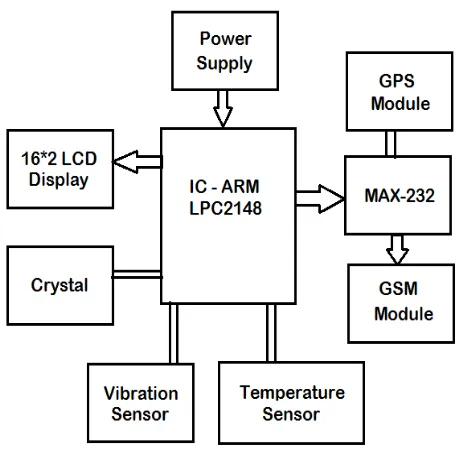
The Hardware framework for the tracking of ship is shown in Fig 1. This system design contains a microcontroller, GPS, GSM modem and LCD display unit and all system reside on a ship. This tracking system provides the effective tracking of ship and accordingly displays the message. The sensors available with this module provide the relative information about the ship and problems arises in ship. The Global Positioning System (GPS) is space based navigation system that provides the location and timing information in all condition this receiver is
reside in the ship and is interfaced with that of the MAX232IC. A microcontroller retrieves the information detail from the GPS module and sends it to the particular base station over GSM modem. And LCD display is used to display the corresponding message about the ship.
Fig -1: Block Diagram of transmitter
[image:2.595.321.552.194.423.2]© 2016, IRJET ISO 9001:2008 Certified Journal
Page 342
Fig -1: A system unit for ship tracking
Fig -3: Receiver Unit
This project uses sensors
1. ARM LPC2148 controller
2. GPS Module
3. GSM Modem
4. MAX232
5. Display 16*2 LCD
6. Power Supply Unit.
7. Temperature sensor (LM 35)
8. Vibration Sensor.
This project uses ARM - LPC 2148 for processing all the things i.e. collection of all information from the sensors i.e. temperature sensor, vibration sensor and location related information from GPS Module. This information collects and transmits with the help of GSM Module.
Finally the information will be reach at the receiver mobile phone.
2.1 GSM Module
Fig -4 GSM Module
GSM (Global System for Mobile communications). GSM is a digital cellular model for communications system. It is used for transmitting mobile voice and data services. It has international roaming capability. It has encryption capability for information security and privacy. It is having Better security against fraudulent (through the terminal validate and used for user authentication).
2.2 GPS RECEIVER
The Global Positioning System (GPS) is a space-model satellite navigationally system that provides location and time information in all weather, everywhere on or near to the Earth, where there is an unclogged line of sight to four or more GPS satellites. Fig. shows the interfacing of the GPS with that of the microcontroller. The GPS module continuously transmits serial data (RS232 protocol) in the form of serially according to NMEA standards. The latitudes and longitudes values of the location are
contained in the GPGGAset of event(reference to that of
© 2016, IRJET ISO 9001:2008 Certified Journal
Page 343
Fig-5:Circuit Diagram to Interface GPS with LPC2148
Fig -6: Pin Assignment with LPC2148
The Hardware interfaces GPS receiver unit on the ship. GPS module has pretty good sensitivity with excellent tracking capability even in urban condition. It is one of the novel method which is used for the ship tracking along with DGPS (Differential Global Positioning System) it forms a triangulation to find the exact location of the object. The GPS smart antenna will track up to 32 satellites at a time while understanding the fast time to first fix, one second navigation update and low power consumption. It can supply you with quality sensitivity and performance even in urban canyon and dense foliage environment. Its far reaching capability needs the sensitivity requirement of ship navigation as well as location and through this the information is available at the base station in continuous manner at every moment.
Fig -7 GPS Receiver
2.3 Temperature sensor
This type of sensors is used to identify the temperature rises against cold and burning, the LM35 series are precision integrated circuit the degree sensor it has analog output which is used linearly proportional to the environing temperature. The LM35 has very extent reactance and sequential output and callibration which makes interfacing and control circuitry easy. It can be used as a supply voltage and output is adjust in design connection and operated at a the degree of coldness settled in between -55c to +150c range. The linear temperature can have ranges from +10.0mv/c scale factor and it has very low self heating capbility.
Fig -8 Temperature sensor
2.4 Vibration sensor
In this project we are using sensors that is used to track the problems in ship that is incorrect position in ocean, temperature changes against cold and burning. In this we have use the vibration sensor LDTM-028K is a vibration sensor where the sensing element can comprises of a cantilever beam and loaded by an additional mass which offer high sensitivity at low frequencies. LDTM-028K is a variable component comprising of a 28 um thick piezoelectric PVDF polymer film are screen printed Ag-ink electrodes, laminated to a 0.125mm polyster substrate, and fitted with two crimped contacts. This is low cost vibration sensor.
Fig -9 Vibration sensor
2.5 MAX232
© 2016, IRJET ISO 9001:2008 Certified Journal
Page 344
packages with temperatures from 0 to +70°C up to -55°Cto +125°C. See arrangement of information table at the end of the data sheet for all collection of data and temperature options.
Fig -10 Max IC
In this system work the GPS unit is connected with that of the MAX232IC and these unit is reside on the ship. The MAX232 device is a dual driver and receiver that includes a capacitive voltage generator which is used to give supply voltage TIA/EIA-232-F voltage levels with a single 5-V supply. Each of the receiver get converts TIA/EIA-232-F of inputs to 5-V TTL/CMOS levels. This meets or exceeds TIA/EIA-232-F and ITU recommendation v.28. this operates up to 120kbits/s. This MAX232IC has two drivers and two receivers. These receiver have a threshold voltage
of 1.3v, and a typical voltage of 0.5v and can accept +30v inputs. Each drivers get converts TTL/CMOS input levels into TIA/EIA-232-F levels. It has low supply current typically of 8milli-ampere.
Fig -11 Simplified Schematic
2.6 ARM LPC 2148
© 2016, IRJET ISO 9001:2008 Certified Journal
Page 345
This simplicity results in a high instruction processed andquality of a real-time interrupt response from a small and cost-existing processor core. Pipeline employ the technical skills and are make use of all parts all parts of the
processing and memory systems can operate
continuously. Generally, while one instruction is being carried out its successor is being decoded and a third instruction is being delight in from memory. The ARM7TDMI-S processor also give work to a unique architectural strategy known as Thumb, which makes it ideally right to great volume applications with memory restrictions, or applications where code density is an issue. The key aim behind Thumb is that of a excellent and smaller instruction set.
The ARM7 LPC2148 Primer board is specifically designed to help to master the required skills in the area of embedded systems. The kit is designed in such way that all the possible distinctive attribute of the microcontroller will be easily used by the students. The kit endures in system programming (ISP) which is done through forming part of port. NXP’s ARM7 (LPC2148), ARM Primer Kit is put forward to bitterness the progress of developing and identify and removes errors of various designs are hold within the High speed of 32-bit Microcontrollers.
Fig -12 LPC2148 Processor
The ARM7 has a group of related things and is the world’s large area uses 32-bit embedded processor . ARM is the industry's leading provider of embedded microprocessors. With more than 30 billion processors already created and in excess of 16 million shipped every day. The 16/32-bit ARM7TDMI-S microcontroller in a tiny LQFP64 package. 512 Kb of on-chip flash program memory. Single 10-bit D/A converter provide noon consistence analog output.
Multiple serial meet and interact with the two UARTs, two Fast I2C-bus and variable data length capabilities. Two 10-bit A/D converters provide a total of 8analog inputs, with conversion times as low as 2.44 μs per channel speed 60 MHz operations.
Testing the GPS with LPC2148 :
Give +3.3V power supply to LPC2148 Primer Board; associate with +5V adapter with GPS unit is connected with the LPC2148 Primer Board or with a hard material. Allowing access to the Hyper Terminal screen, and pick out which port you are using and set the fail to fulfill obligation settings. Now the screen should show some text messages.
Sensor:
A piezoelectric sensor is used as unintentionally detection sensor. A piezoelectric transducer has very great DC output impedance and can be use as a corresponding size
of voltage, sourceand filter network. The voltage V at the
source is directly related in size and put to practical use of force, pressure, or strain. The output signal is then connected to this mechanical force as if it had passed through the equivalent circuit.
Fig -13 Circuit Diagram
© 2016, IRJET ISO 9001:2008 Certified Journal
Page 346
- LPC 2148 used MAX 232. To provide power tomicrocontroller unit, GPS unit, GSM Unit here used multiple power supply as per individual units requirements.
Finally the information will be reach at the receiver mobile phone
Fig -14 Power Supply
3. CONCLUSIONS
This project uses a GPS tracking system to find the exact location of ship, and is becoming increasingly important because it is more accurate in function and with the help of this system location of the navigation becomes easier. This is able to track the location of the ship at the real time. The proposed work gives us pre-analysis and tracking of ship which is useful as far as security is concerned, by interfacing the sensors we can easily pre-analysis and sense the problems of pre accident in ship and send alert to the base station. By enhancing this setup and upgrading it can be used for the future requirement and is more efficient for the safety purpose.
ACKNOWLEDGEMENT
I Like to have an obligation to PROF.S.B.ROTHE (assistant professor Depart. of Electronics and Telecommunication System, GHRIETW, Nagpur, Maharashtra for providing his propitious advice.
REFERENCES
[1] .Elia Nadira Sabudin, Siti Zarina Mohd Muji,
Mohd., Helmy Abd Wahab, Ayob Johari, Norazman Bin Ghani,“GSM-based Notification Speed Detection for Monitoring Purposes”, IEEE,
Department of Computer Engineering, University Tun Hussein Onn Malaysia in 2008.
[2] M. AL-Rousan, A. R. AI-Ali and K. Darwish “GSM-Based Mobile Tele-Monitoring and Management System for Inter-Cities Public Transportation”,
International Conference on Industrial
Technology (ICIT), Computer Engineering Dept., American University of Sharjah, UAE in 2004, pages 859-862.
[3] Stephen Teang Soo Thong, Chua Tien Han and
Tharek Abdul Rahman “Intelligent Fleet
Management System with Concurrent GPS & GSM Real-Time Positioning Technology”, IEEE,
Wireless Communication Centre (WCC), universiti Teknologi Malaysia (UTM), Malaysia in 2007. [4] Wright, M., Stallings, D., Dunn, D.: The
Effectiveness of Global Positioning System Electronic Navigation. April 2003, IEEE
Southeastcon 2003. Bridging the Digital Divide. Renaissance Jamaica Granade Resort Ocho Rios, St. Ann, Jamaica W.
[5] Li Liu, YanfangJing, Zengxiao Chi, JianBangChen,
ChaoMa, “Design and implementation of Android Phone Based Group Communication and
Navigation System”, 2nd International Conference on Consumer Electronics, Communications and Networks 2012, 21-23 April 2012, pp 3174-3177, ISBN:978-1-4577-1414-6.
BIOGRAPHIES
Pursuing MTECH (VLSI) student
of G.H Raisoni institute of
engineering technology for
women’s, GHRIETW college
comes under RTMNU university, area of interest is embedded systems, VLSI design.
Prof.S.B.Rothe Sir is currently working as assistant professor in the department of electronics and Communication in G.H.Raisoni institute of Engineering and
technology for women’s,
GHRIETW College comes under RTMNU university. He received her Master of technology degree
in Electronics and