A previous approach to particular functions of the forest preferred the wood-producing role of the forest and other functions of the forest were called non-wood-producing roles. The present conception of a plan of the main forest road network is mainly based on technical and economic aspects. It results particularly from the ground configura-tion and from the calculaconfigura-tion of minimum costs for log-ging and timber transport. The optimum density of main forest roads is determined by a minimum value of the summary curve of forest road construction costs and costs of skidding operations.
A new philosophy of forest stand management is based on the idea of the equal value of all forest functions and their respect on the principle of sustainable management. The respect for the particular roles of the forest has not manifested yet in the field of the opening-up of forests. The objective of this study is to apply the evaluation of the par-ticular forest functions to the present method of main forest road location and to the plan of road network optimisation. Such an optimised plan can be considered as a design that is characterised by the attributes of technical-economic-environmental conception (HRŮZA et al. 2000).
MATERIAL AND METHODS
The study is based on the results of research activities of Professor Beneš. It uses and extends methods of the plan
of an optimum road network in the “gravitational area” of the Babický potok stream, Training Forest Enterprise Křtiny. The “gravitational area” is a transport region where wood transport is concentrated to one place. Ac-cording to Beneš, these gravitational segments usually correspond to small watersheds of an area of about 500 ha. The evaluation of ground configuration is based on the ground slope, density of watercourses and the coefficient of segmentation of a mean contour line. The coefficient of ground shape determines the required density of the main road network per hectare.
Opening-up effectiveness is the basic parameter for select-ing the most suitable variant of the main road location in the gravitational area under study. The parameter expresses the effectiveness of the main forest road location. Under regular distribution, the effectiveness of opening-up is maximum with respect to the given road density. However, an ideally distributed road network does not occur in practice.
The aim of this study is to determine how the respect of the particular functions will manifest itself in the change in parameters of forest opening-up in comparison with plans of the optimised road network carried out by Professor Beneš and in comparison with the present condition.
The following parameters are assessed (BENEŠ 1986): Density of main forest roads (HS) – expressed by the ratio of the length of main forest roads in metres to the area (in hectares) made accessible.
The paper refers to Research Project Ministry of Education, Youth and Sports of the Czech Republic No. 1035-9 ZA 05 entitled Technical Aspects of Sustainable Landscape Stability.
Optimisation of forest road network under principles of functionally
integrated forest management
P. H
RŮZAMendel University of Agriculture and Forestry, Faculty of Forestry and Wood Technology,
Brno, Czech Republic
ABSTRACT: A traditional approach to problems of the opening-up of forests has been based primarily on technical and economic aspects. It results particularly from the ground configuration and calculations of minimum costs for logging and transport operations. Optimum density of main forest roads is determined by a minimum value of the summary curve of costs of forest road construction and timber skidding. A new conception from the aspect of integrated forest management taking into account forest functions is based on a standard approach when technical and economic aspects are complemented by the particular functions of the forest. Thus, the technical and economic approach is changed to a technical-economic-environmental conception that will contribute to a reduction in negative effects of the construction of forest road network on the environment.
Keywords: forest road network; optimisation; forest functions; gravitational area; road network density; opening-up effectiveness; skidding distance; main forest road
Skidding distances (DS) – route length in metres. Skidding means hauls of wood along the trail to a main skidding road. Average skidding distance (DSX) is an arithmetic mean of skidding distances in the area made accessible.
Geometrical skidding distance (DG) – the shortest dis-tance in metres from the stump of a skidded log to a main forest road. The average geometrical skidding distance (DGX) is the arithmetical mean of geometrical skidding distances. Its length is related to the layout of main forest roads, particularly to their uniform distribution throughout the area made accessible. For example, the layout of main forest roads along the edge of a forest, their excessive crossing, the layout of main forest roads along both sides of a watercourse increase its value. Under optimum con-ditions, the average geometrical skidding distance ranges between 140 and 180 m (BENEŠ 1991).
Theoretical skidding distance (DT)– average skidding distance in metres under optimum distribution of forest roads throughout the area made accessible. It is related to road density and is given by the following relation:
DT = 10,000/(4HS )
Effectiveness of the opening-up of a gravitational area (U) – expresses the efficiency of main forest road distribu-tion in the area made accessible and in the design of the opening-up of a forest in the region of uplands it is one of the most important criteria. It is a relative value inde-pendent of road density. The effectiveness is expressed by the ratio of a theoretical skidding distance and an average geometrical skidding distance given in %.
Optimisation of the forest road network regarding the functions of the forest supposes to take into account the realistic potential of forest functions in addition to the criteria given above. The realistic potential of the func-tions assesses functional capacities of stands under
op-timally possible ecosystem conditions (VYSKOT 1999).
The evaluation scale of fulfilling the potential consists of seven classes and evaluation is carried out separately for each of the stands.
The objective of the road network design is to take into account stands with the high value of fulfilling the realistic potential and adaptation of the optimised plan of a forest road network in such a way that the stands be disturbed as little as possible. The plan of a forest road network is, therefore, directed to stands with the low value of fulfilling the realistic potential. No marked decrease in its fulfilling due to the construction and use of the road network can occur there. An adapted plan has to fulfil the primary requirement for respecting the ground configuration. Parameters of main forest roads are given by the Standard ČSN Forest Road Network and Decree No. 433/2001.
For the particular functions of the forest, maps of realistic potentials were constructed and their values were indicated in colour. Evaluation was carried out for the following functions: bioproduction (Bp), ecological/ stabilisation (Es), edaphic/soil-conservation (Ec), hydric/ water-management (Hw), social/recreation (Sr) and health/ hygienic (Hh). Forest general maps at a scale of 1:10,000 served as a source for distinguishing the realistic poten-tials. For processing, TOPOL software was used. The values of realistic potential for the particular functions were indicated in colour.
[image:2.595.87.510.516.732.2]Maps prepared in this way were used as a basic layer for further processing using AutoCAD software. As the next layers, the present condition of the road network and the plan of optimisation of the forest road network according to Beneš were fed in. Then, a plan for the optimum accessibility to the gravitational area was prepared. The plan was based on Beneš’s design and on
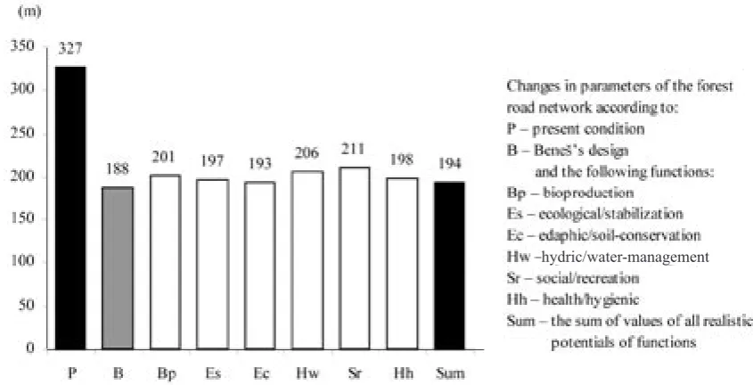
Fig. 1. Changes in parameters – average skidding distance (DSX)
taking into consideration stands with the high value of realistic potential.
RESULTS AND DISCUSSION
For each of the particular functions, evaluation of the plan of a forest road network was carried out respecting the given function of the forest and its comparison with the actual condition and with the plan of optimisation ac-cording to the traditional approach.
The area of the gravitational area of the Babický potok stream amounts to 424 ha, the present density of the main forest road network is 19.8 m/ha and the length of truck roads is 8,390 m. The effectiveness of opening-up equal to
50.3% corresponds to the value of effectiveness attained by the present road network which provides access to the majority of forests in the Czech Republic (BENEŠ 1980,
1989, 1991).
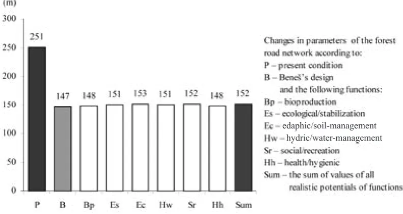
At present, average skidding distance is 327 m. Average geometrical skidding distance best representing the uni-formity of forest roads in the gravitational area reaches a value of 251 m. Theoretical skidding distance dependent on the road network density is 126 m.
For the present forest road network, optimisation was designed according to the research results (BENEŠ
[image:3.595.79.475.62.272.2]1991) for the purpose of decreasing the average skidding distance. Thus, the present length of hauling routes was extended by 2,996 m to a length of 10,384 m. The design Fig. 2. Changes in parameters – average geometrical skidding distance (DGX)
Fig. 3. Changes in parameters – main road density (HS), theoretical skidding distance (DT), effectiveness of the opening-up (U)
hydric/water-management
hydric/water-management edaphic/soil-management edaphic/soil-management
[image:3.595.80.510.530.725.2]increased the effectiveness of opening-up by 19.3% to a value of 69.6% and the truck road network density was increased by 4.7 m/ha to a value of 24.5 m/ha. Average skidding distance decreased to a value of 188 m and the decrease amounted to 139 m. Average geometrical skid-ding distance reached a value of 147 m being decreased by 104 m. Theoretical skidding distance reached a value of 102 m.
For each of the particular functions, evaluation was carried out of the design respecting a given function of the forest and its comparison with the actual condition and with the optimisation design according to Beneš. The same parameters of the opening-up and the extent of their changes were evaluated.
Density of the forest road network ranges in an in-terval from 23.52 to 24.74 m/ha (96–101% of Beneš’s design).
Average skidding distance ranges in an interval from 193 to 211 m (102–112% of Beneš’s design).
Average geometrical skidding distance reaches a value of 148 to 153 m (100–104% of Beneš’s design).
Theoretical skidding distance reaches a value of 101 to 106 m (99–103% of Beneš’s design).
Effectiveness of the opening-up ranges in an interval from 68 to 70% (98–101% of Beneš’s design).
Based on the results obtained it is evident that the frame of the accessibility optimisation according to the author is not substantially changed. Changes occur particularly in laying out main forest roads that are directed at a ridge where they are terminated by a turning place not forming a closed unit of the opening-up. No significant change in the parameters of opening-up occurred in any of the functions, i.e. none of the functions can be deter-mined as governing from the aspect of accessibility in the gravitational area of the Babický potok stream. Figs. 1–3 show that the magnitude of a difference in the particular parameters of opening-up is minimum and constant. In none of the functions does a marked deviation occur.
In planning the optimisation of opening-up of a gravi-tational area taking into account the functions of the for-est, it is possible to proceed in the first stage similarly like in the traditional approach, i.e. assessment of the ground configuration and minimisation of costs of road building and skidding. In the second stage, with respect to the results of evaluation of the effect of particular functions on the parameters of opening-up, it is possi-ble to create a plan on a map basis reflecting the sum of values of all realistic potentials of forest functions for a given stand. On the map basis, a plan was created of the opening-up of the Babický potok stream gravitational area and the general effect of functions was evaluated on the opening-up parameters. The results confirmed that all values ranged in the interval of values for particular functions.
Road network density reaches a value of 23.68 m/ha (97% of Beneš’s design).
Average skidding distance is 194 m (103% of Beneš’s design).
Average geometrical skidding distance is 152 m (103% of Beneš’s design).
Theoretical skidding distance is 106 m (103% of Beneš’s design).
Effectiveness of the opening-up amounts to 69% (100% of Beneš’s design).
A final plan can be considered as a design of the gravi-tational area accessibility that fulfils the present require-ments for integrated management in forest stands and takes into account a requirement for the equivalence of forest functions.
CONCLUSION
The new conception of optimisation of the forest road network taking into account the functions of the forest is based on a traditional approach when technical and economic aspects are complemented by respecting the particular functions of the forest. Thus, the technical and economic approach turns into an integrated techni-cal-economic-environmental conception. A plan of forest road network should be a decisive factor for the proposal of logging and hauling technologies.
Based on the plan, machinery of enterprises carrying out logging and transport operations in certain areas should be selected. It means not to plan a road network commensu-rate with used logging and hauling technology and related machinery in this area.
References
BENEŠ J., 1980. Určení technicko-ekonomických kritérií plánování výstavby lesní dopravní sítě. [Doktorská práce.] 195.
BENEŠ J., 1986. Optimalizace lesní dopravní sítě. Lesnictví, 32: 1089–1114.
BENEŠ J., 1989. Zpřístupnění horských lesů. Lesnictví, 35: 153–171.
BENEŠ J., 1991. Zpřístupnění lesů v pahorkatinách. Lesnictví, 37: 245–266.
HRŮZA P., SKOUPIL J., HANÁK K., 2000. Forest Road Net-work Formation and Optimisation and its Effects on Ru-noff Conditions and Minimisation of Erosion Damages. Mezinár. věd. konf., 20.–22. 11. 2000. Brno, MZLU: 117–125.
VYSKOT I., 1999. Potenciály funkcí lesů. Praha, MŽP ČR: 53.
Studie vychází z výsledků výzkumné činnosti prof. Beneše, využívá a rozšiřuje metodiku návrhu optimální cestní sítě v gravitačním území Babického potoka na Školním lesním podniku Křtiny. Účelem práce je aplika-ce hodnoaplika-cení jednotlivých funkcí lesa do současné me-tody trasování lesních odvozních cest a návrhu optimali-zace cestní sítě. Takto optimalizovaný návrh lze označit za návrh, který v sobě nese atributy technicko-ekono-micko-ekologického pojetí. Cílem studie je stanovit, jak se respektování jednotlivých funkcí lesa projeví na změně parametrů zpřístupnění lesa ve srovnání s návrhy optimalizované cestní sítě prof. Beneše a ve srovnání se současným stavem. Posuzovanými parametry jsou husto-ta odvozních cest, přibližovací vzdálenosti, geometrická přibližovací vzdálenost, teoretická přibližovací vzdále-nost a účinvzdále-nost zpřístupnění gravitačního území.
Pro jednotlivé funkce lesa byly zpracovány mapy reál-ných potenciálů a jejich hodnoty byly barevně odlišeny. Mapy byly použity jako podklad pro návrh nové optima-lizované cestní sítě.
Hodnocení probíhalo pro funkci bioprodukční, ekolo-gicko-stabilizační, edaficko-půdoochrannou, hydricko--vodohospodářskou, sociálně-rekreační a zdravotně-hy-gienickou. Účelem návrhu cestní sítě je pak respektování porostů s vysokou hodnotou naplnění reálného potenciá-lu a úprava optimalizovaného návrhu lesní cestní sítě tak, aby tyto porosty byly co nejméně porušeny. Návrh
cestní sítě je z toho důvodu směřován do porostů s níz-kou hodnotou naplnění reálného potenciálu. Zde nemůže docházet vlivem výstavby a využívání cestní sítě k vý-raznějšímu snižování jeho plnění.
Z výsledků je zřejmé, že kostra optimalizace zpří-stupnění se u jednotlivých funkcí zásadně nemění. Při návrhu optimalizace zpřístupnění gravitačního území, který respektuje funkce lesa, lze tedy postupovat v první fázi obdobně podle klasického přístupu: zhodnocením konfigurace terénu a minimalizací nákladů na výstavbu komunikací a přibližování dříví. Ve druhé fázi je vzhle-dem k výsledkům hodnocení vlivu jednotlivých funkcí na parametry zpřístupnění možné vytvořit návrh na ma-povém podkladu, který zobrazuje součet hodnot všech reálných potenciálů funkcí lesa u daného porostu. Na tomto mapovém podkladu byl vytvořen návrh zpřístup-nění gravitačního území Babického potoka a zhodnocen celkový vliv funkcí na parametry zpřístupnění. Výsledky potvrdily, že všechny hodnoty parametrů takto vytvořené cestní sítě se pohybují v rozmezí intervalů hodnot jednot-livých funkcí.
Mapa součtu hodnot všech reálných potenciálů by se měla stát součástí návrhu optimalizace lesní cestní sítě. Respektováním jednotlivých funkcí lesa se sníží negativ-ní účinky výstavby lesnegativ-ní cestnegativ-ní sítě na životnegativ-ní prostředí při zachování současných nákladů na její výstavbu.
Optimalizace lesní cestní sítě v principech funkčně integrovaného lesního hospodářství
P. HRŮZA
Mendelova zemědělská a lesnická univerzita, Lesnická a dřevařská fakulta, Brno, Česká republika
ABSTRAKT: Klasický přístup k problematice zpřístupňování lesa je doposud založen především na technicko-ekonomických aspektech. Vychází zejména z konfigurace terénu a z výpočtu minimálních nákladů na těžbu a dopravu dřeva. Optimální hustota lesních odvozních cest je určena minimem součtové křivky nákladů na stavbu lesních cest a nákladů na soustřeďování dříví. Nové pojetí z hlediska funkčně integrovaného lesního hospodářství respektující funkce lesa vychází z klasického přístupu, kdy technicko-ekonomické aspekty jsou doplněny o respektování jednotlivých funkcí lesa. Z technicko-ekonomického přístupu se stává technicko-ekonomicko-ekologické pojetí, které přispěje ke snížení negativních účinků výstavby lesní cestní sítě na životní prostředí.
Klíčová slova: síť lesních cest; optimalizace; funkce lesa; gravitační území; hustota cestní sítě; účinnost zpřístupnění; přibli-žovací vzdálenost; odvozní cesta
Corresponding author:
Ing. PETR HRŮZA, Mendelova zemědělská a lesnická univerzita, Lesnická a dřevařská fakulta, Lesnická 37, 613 00 Brno, Česká republika