COMPUTER GRAPHICS AND INTERACTIVE SYSTEMS LABORATORY Contact details
Name Computer Graphics and Interactive Systems Laboratory
Acronym CGIS
Logo
Site http://cgis.utcluj.ro
Address 26-28 G. Baritiu Str., 400027, Cluj-Napoca, Romania Faculty
Department
Faculty of Automation and Computer Science Computer Science Department
Telephone +40 264 401478
Fax +40 264 594491
Director Prof. Dr. Eng. Dorian Gorgan
e-mail [email protected]
Areas of expertise
Computer graphics, user interaction techniques, graphics modelling and simulation, distributed interactive application development methodologies, Grid, Cloud, and Web applications development, Earth Science applications and tools development, graphics cluster based processing and visualization, and e-learning systems development.
Team and key skills
Prof. Dr. Eng. Dorian Gorgan is the chair of the CGIS Laboratory. He was the initiator and the director of the MedioGrid project and of the national research and academic Grid infrastructure. He is involved in other international research and collaborative projects such as enviroGRIDS, GiSHEO, SEE-GRID-SCI, mEducator, COST IC0805, and I-Trace.
Assist. Eng. Victor Bâcu has significant contribution to national and international projects including MedioGrid, SEE-GRID-SCI, GiSHEO, and enviroGRIDS. His research interests focus on Grid and Cloud infrastructures, Earth Science platform and applications development, and cluster based processing and visualization.
Assist. Eng. Teodor Ştefănuţ has significant contribution to national and international projects including I-Trace, mEducator, GiSHEO, and enviroGRIDS. His research interests focus on Web technologies, interactive application development, tool packages for flexible classification of satellite images, and high performance computation.
Eng. Denisa Rodilă is member of the CGIS Laboratory, and her main contribution is in GiSHEO, SEE-GRID-SCI and enviroGRIDS international projects. Her area of interest includes scalable distributed computing, Grid and Cloud applications development, service oriented technologies, and distributed platforms interoperability.
Eng. Dănuţ Mihon is member of the CGIS Laboratory, and his fields of interest concern with distributed processing of satellite images, spatial data processing and visualization, Earth Science oriented applications development, Grid computing, and geospatial services. He has been involved in the SEE-GRID-SCI and enviroGRIDS research projects.
Infrastructure Computing Server
- 2 servers IBM M3, quad-core, 2.13 GHz, 48 GB
- 3 servers ML350, 2 x 250GB, Hot Plug Drive 4 x HP 500GB Graphics Cluster
- 3 nodes Intel dual-core, NVidia GFGTS250, 512MB - 2 nodes Intel dual-core, NVidia EN8800GTS, 512MB Grid Node in EGEE
- Worker Nodes: 128 quad-core processors (512 cores), 128Gb RAM - Storage Element: 12TB
Development strategy
- Involvement in interdisciplinary research through collaborative scientific and industrial projects.
- Giving high level scientific expertize that requires experience acquired in successful international reasearch projects. - Extend the international collaboration in scientific research.
- Promote the young scientists in advanced scientific research.
Representative projects
EnviroGRIDS - Building Capacity for a Black Sea Basin Observation and Assessment System supporting Sustainable Development. FP7 project, funded by the European Commission (2009 - 2013),
http://www.envirogrids.net/.
SEE-GRID-SCI - SEE-GRIDeInfrastructure for regional eScience. FP7 project, funded by the European Commission (2008 - 2010), http://www.see-grid-sci.eu/.
IC0805 - Open European Network for High-Performance Computing in Complex Environments. COST Project (2009-2013), http://complexhpc.org/
mEducator - Multi-type Content Repurposing and Sharing in Medical Education. eContentplus - Digital Content and Cognitive Systems Programme funded by European Commission (2009-2012), http://www.meducator.net/. GISHEO - On demand Grid services for high education and training in Earth observation. Funded by European Space Agency through PECS Programme (2008-2010), http://gisheo.info.uvt.ro/.
MedioGrid - Parallel and distributed graphical processing on GRID structure of geographical and environment data, 19CEEX-I03 (2005-2008).
I-TRACE - Interactive Tracing and Graphical Annotation in Pen-based e-learning, 223434-CP-I-2005-IT-Minerva-M (2005-2007).
Significant results
Selected 10 papers of 2012 (more at http://cgis.utcluj.ro/publications):
1. D. Gorgan, V. Bacu, T. Stefanut, D. Rodila, D. Mihon, Earth Observation application development based on the Grid oriented ESIP satellite image processing platform, Journal on Computer Standards & Interfaces, 34, 2012, 2012, pp. 541–548.
2. D. Gorgan, V. Bacu, D. Mihon, D. Rodila, K. Abbaspour, and E. Rouholahnejad, Grid based calibration of SWAT hydrological models, Journal of Nat. Hazards Earth Syst. Sci., 12, 2012, pp. 2411-2423.
3. D. Rodila, V. Bacu, D. Gorgan, Comparative Parallel Execution of SWAT Hydrological Model on Multicore and Grid Architecture, International Journal of Web and Grid Services, Vol. 8, No. 3, 2012, 2012, pp. 304-320.
4. V. Bacu, D. Gorgan, Grid application oriented computational resource allocation strategy. International Conference on High Performance Computing and Simulation (HPCS), 2012, pp. 581-587.
5. D. Gorgan, V. Bacu, D. Mihon, T. Stefanut, D. Rodila, P. Cau, K. Abbaspour, G. Giuliani, N. Ray, A. Lehmann, Software platform interoperability throughout enviroGRIDS portal, in International Journal of Selected Topics in Applied Earth Observations and Remote Sensing – JSTARS, Vol. PP/99, 2012, pp. 1-11.
6. D. Rodila, D. Gorgan, Mapping Geospatial Applications onto Parallel and Distributed Environments, 6th International Conference on Complex, Intelligent and Software Intensive Systems (CISIS), 2012, pp. 443-448. 7. N. Ray, G. Giuliani, D. Gorgan, A. Lehmann, Distributed geocomputation for modeling the hydrology of the Black
Sea watershed. Watershed Approach to Environmental Security: Fostering integrated water management in the Azov Sea Basin, ed. Lagutov, V. NATO Science for Peace and Security Series: Environmental Security, Part 2. Dordrecht, Springer, 2012, pp. 141-158.
8. D. Rodila, D. Gorgan, Geospatial and Grid Interoperability through OGC Services Gridification. IEEE Journal of Selected Topics In Applied Earth Observations and Remote Sensing (J-STARS), Interoperability Architectures and Arrangements for Multi-Disciplinary Earth Observation Systems and Applications Special Issue, (accepted for publication), 2012.
9. D. Mihon, V. Bacu, D. Rodila, T. Stefanut, K. Abbaspour, E. Rouholahnejad, D. Gorgan, Grid Based Hydrologic Model Calibration and Execution. Chapter in the book: Advanced in Intelligent Control Systems and Computer Science, Dumitrache I. (Ed.), Springer-Verlag (accepted for publication), 2012.
10. D. Petcu, S. Panica, M. Frincu, M. Neagu, D. Zaharie, G. Macariu, D. Gorgan, T.Stefanut, Experiences in building a Grid-based platform to serve Earth observation training activities. Journal of Computer Standards & Interfaces, Vol. 34/6, Nov. 2012, 2012, pp. 493–508.
Software tools and platforms developed by CGIS Laboratory:
gSWAT - gSWAT - platform and application allows the user to calibrate and execute the SWAT hydrological models in a flexible and interactive manner by taking advantage of the Grid infrastructure.
gSWATSim – is a collection of Web services supporting the Grid based calibration and execution of the SWAT hydrological models. It provides the SWAT related basic functionality required to develop a remote Web application. GreenLand – is a platform and application for Grid based satellite image processing and visualization. The processing is described by an interactive graphical editor. The application is connected by standard geospatial services to spatial data repositories.
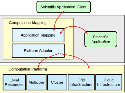
ESIP – Grid based satellite image processing platform. GreenLand is layered on ESIP and gProcess. gProcess – Grid oriented task management and execution platform. gProcess is the basic platform for ESIP, Greenland, and gSWAT.
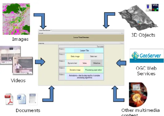
eGLE – eLearning Platform for Earth Science domain. It supports the development and execution of teaching materials including Grid based processing of satellite images, and connectivity by geospatial Web services.
satellite images.
eTrace – eLearning platform for developing learning materials by graphical annotations on 3D objects. MedioGrid – first national Grid infrastructure for research and education (2006).
The offer addressed to the economic environment Research & development in core
areas
- Grid and Cloud computing.
- Graphics Cluster based processing and visualization. - Graphics user interaction in eLearning applications. - Geospatial service oriented architectures.
Research & development in applied fields
- Development of Earth Science oriented applications. - Satellite image processing and classification. - Particle based modelling of dynamical 3D surfaces. Consulting - Graphics modelling and simulation.
- User interactive application development methodology. - Grid and Cloud computing.
- Earth Science oriented application development. Applied engineering services - High performance computation.
- SWAT hydrological model calibration and execution (gSWAT application and gSWATSim services).
- Satellite image processing (GreenLand application). Training - User interactive application development methodology.
- Usability evaluation of graphical user interfaces. Pictures with CGIS Laboratory activity:
Fig. 3. eGLE eLearning platform for teaching materials development and execution. Fig. 2. Teaching material composition in eGLE platform.
Fig. 5. Earth Science applications scalability on different execution platforms. Fig. 4. Spatial data visualization of hydrological model in gSWAT application.