Transportation Research Procedia 3 ( 2014 ) 1051 – 1058
2352-1465 © 2014 The Authors. Published by Elsevier B.V. This is an open access article under the CC BY-NC-ND license (http://creativecommons.org/licenses/by-nc-nd/3.0/).
Selection and peer-review under responsibility of the Scientific Committee of EWGT2014 doi: 10.1016/j.trpro.2014.10.085
ScienceDirect
17th Meeting of the EURO Working Group on Transportation, EWGT2014, 2-4 July 2014,
Sevilla, Spain
Level of service estimation based on low-frequency
floating car data
Steffen Axer*, Bernhard Friedrich
Technische Universität Braunschweig, Institute for Transportation and Urban Engineering, Rebenring 31, 38106 Braunschweig, Germany
Abstract
Systematic and network-wide estimation of traffic quality is an essential requirement for a traffic management. Collecting traffic information based on conventional sensor techniques becomes an economical challenge when road authorities are faced with wide-area road networks. With respect to nowadays strictly limited resources, the cost-efficient analysis of historical driving speeds based on mass floating car data (FCD) is getting more and more important in modern traffic management. The representative calculation of typical driving speed for identical weekdays over a certain period allows the ex post identification of periodic bottlenecks and could be also used to evaluate the effects of management strategies. Therefore, the objective of this paper is to present a four stage semi-automatic method for a network-wide level of service estimation based on processing historical FCD. During the first and the second chapter the paper gives a summary over related work in this research field and introduces the used floating car data source as well as the applied digital roadmap based on OpenStreetMap. During the first stage, the developed method establishes an easy to use referencing process between the digital road network and the traffic message channel system (TMC). Based on the road network separation with respect to the TMC-system, the second stage employs a FCD matching algorithm, which allows the detection of driving direction especially for low-frequency floating car data and small TMC-segments. The third stage of the method deals with the systematic and statistical analysis of historical driving speeds. Therefore, the paper analyzes the statistical significance level of derived average driving speeds over two hour time intervals for typical weekdays. The fourth stage of the method describes a self-calibrating level of service calculation process which uses speed indices. Finally, the paper exemplifies results of the developed method for the road network of Hanover (Germany).
© 2014 The Authors. Published by Elsevier B. V.
Selection and peer-review under responsibility of the Scientific Committee of EWGT2014.
Keywords: level of service estimation; floating car data; driving speeds
* Corresponding author. Tel.: +49 531 3917911; fax: +49 531 3918100 E-mail address: [email protected]
© 2014 The Authors. Published by Elsevier B.V. This is an open access article under the CC BY-NC-ND license (http://creativecommons.org/licenses/by-nc-nd/3.0/).
1.Introduction
The periodic estimation of the level of service (LOS) within a road network should be one of the regular tasks of traffic management in order to either maintain a stable traffic flow or to identify and cure bottlenecks. The efficient allocation of resources to cure bottlenecks needs LOS estimation with a high spatiotemporal resolution. Conventional traffic information collection techniques, e.g. local loop detectors or cameras, could not be used network wide with respect to the limited financial resources of road authorities in charge. During the recent years the extensive availability of floating car data (FCD) caused by the popular use of modern smartphone navigation software offers a high potential to overcome the actual situation.
The objective of this paper is to describe a fourth stage concept which allows the FCD processing, a statistical driving speed analysis and the estimation of speed related LOS based on historical FCD and with respect to the geographical referencing system used in the TMC-system (Traffic Message Channel). The developed concept has been tested for the road network of Hanover (Germany) and the surrounding area. The remainder of this paper is organized as follows. Chapter 2 starts with an overview about related work. Chapter 3 follows with a short introduction of the used data sources and gives a brief overview about the test site around Hanover. Chapter 4 exemplifies step by step the developed concept and shows afterwards detailed results of the applied concept. The paper closes with drawn conclusions and identified need for further research.
2.Related work
The processing of FCD could be typically classified in six elementary tasks. In particular these tasks are the collection of raw data, the cleaning of erroneous data samples, the integration of data into a road network, the mining, evaluation and application of traffic information (Ehmke et al., 2010).
A literature review has shown, that many papers exist, which describes mainly the basic principle of the raw data collection and roughly shows possible fields of application (Lorkowski et al. 2005, Schäfer et al. 2002). A detailed description of the identified tasks which are involved in FCD processing is often missing. This leads to several essential questions regarding the tasks of data integration and the later extraction of traffic measures like speed or travel times. While other authors are mainly focusing on the data integration part like it is done in the papers from Lou et al. (2009) and Rahmani et al. (2013) the information mining and its application is not part of research done by this authors. The map matching approach of Lou et al. (2009) could be seen as a central development which allows the data integration of low frequency FCD into a detailed attributed digital map. Nevertheless this data integration requires a digital road network that provides information regarding speed limits, driving direction and turn restrictions. Working together with local road authorities reveals, that the cost intensive purchase of digital maps impedes the establishment of methods and techniques which allows a statistical representative LOS estimation based on historical FCD. The paper from Rahmani et al. (2013) deals about the mining task of traffic information like travel time with respect to typical challenges, like partial link coverage of trajectories, which occurs when working with low frequency FCD. The paper evaluates different approaches to calculate a representative travel time but gives no evidences on how to determine a LOS based on the derived travel times.
Based on this literature analysis it could be stated, that further research could be seen in the description and development of an integrated method which covers all aspects of the FCD processing. Furthermore the crucial point of a process development could be seen on the usage of the free but therefore partly incomplete attributed road network like OpenStreetMap (2013).
3.Used data sources
The main data source of the developed concept are raw FCD of a traffic data provider, which quantifies the driving trajectory of a car with a sampling frequency of up to 1/30 Hz. Every data point stores the local driving speed, azimuth, time and the geographical position. The exemplarily realized data analysis uses FCD of the year 2012 and consists of approx. 28 million data points which are already related to prior selected roads within the test site. Fig. 1 illustrates the selected roads inside the test site. (red lines). The following roads have been analyzed.
x Highways: L190, L382 and L393
x Federal Highways: B3, B6, B65, B217 and B522
x Motorways: A2, A7 and A352
The developed concept uses the Location-Code-List (LCL), which is in Germany maintained by the Federal Road Administration BASt (Bundesanstalt für Straßenwesen). The functionality and the content of the LCL will be explained in subchapter 4.1. The basic road network for the data is derived from the open source map dataset of OpenStreetMap.
4.Four stage semi-automatic method for FCD processing and analysis
4.1.Deriving TMC-segments
The basic requirement for processing FCD is a georeferenced road network, on which driving speeds of cars could be spatially and temporally calculated. A very common referencing system of traffic related information is the TMC-System, which is used in several navigation applications. The georeferencing functionality of the TMC-system is based on the so called Location-Code-List (LCL), which stores traffic related locations inside a relational
database. Every location li is attributed with a location code, location name, geographic position and the logical
membership to a street. In addition, a location stores information about successive and previous locations li+1 and li-1.
In this paper the linear connection between adjacent locations is defined as lij, where i is the start location and j is the
end location. The position of a location is mainly correlated to an intersection. The geographic route between start and end location is not part of the TMC-system. Dealing with TMC-locations and connections between them requires a mapping of the linear connection with respect to the real underlying road network. The mapped
connection is called a TMC-segment and denoted with rij. This mapping process is the first step of the developed
concept and is described in the following.
4.1.1.Selection of necessary roads
While the TMC-system references traffic information mainly on arterial roads, the first step is to reduce the network to a subset of these roads for the later mapping process. Working with relational databases, the existing attribution of the OpenStreetMap (OSM) networks allows an easy selection of these arterial roads. A disadvantage of the crowd sourced OSM network are missing or wrong information of driving directions. This problem occurs especially on network parts which could be driven in both driving directions. Due to this issue the reduced network is seen as an undirected graph at this part of the mapping process. The following tasks are necessary to get a correctly directed network.
4.1.2.Generation of intermediate points
To obtain a correctly directed network, the used process needs intermediate points p, which have to be inserted
manually into the selected network. Every intermediate points p stores an ascending number c, its driving direction
d = {0,1} and its street membership S. These additional intermediate points are used as a source and target node for a
shortest-path-routing between adjacent and ascending intermediate points. They could be also interpreted as an orientation mark to guarantee that shortest-path-routing takes the correct way through the selected network. The
result of all shortest-path-routings between adjacent and ascending points pS,d of a certain direction are correctly
directed network segments, which could be easily joined to a larger direction dependent street geometry Sd.
4.1.3.Projection of locations and calculation of TMC-segments
During a last step the geographical point of a location is projected perpendicular to the directed network. This process has to be executed separately with both driving directions of the network. The result of this step are directed
locations li,d=1and li,d=0. Finally the relative position of every directed location could be calculated with respect to its
road membership and dependent to a directed street geometry Sd. A TMC-segment rij could be easily calculated as
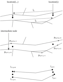
the line between two relative positions of adjacent locations. Fig. 2 illustrates the explained process.
Fig. 2 Method for deriving TMC-segments
location(li+1) location(li)
lij lji intermediate node pS,d=1,c=0 pS,d=1,c=1 pS,d=1,c=2 pS,d=0,c=0 pS,d=0,c=1 li,d=0 li+1,d=0 li+1,d=1 li,d=1
୩ǡ୧୨ൌ ݔെ ݔ௦ ݐെ ݐ௦ (1) തതത୧୨ൌ σ ɏ ୩ǡ୧୨ή ୩ǡ୧୨ σ ɏ ୩ǡ୧୨ (2)
4.2.Matching and driving direction detection of FCD
In the second stage of the developed concept trajectories have to be matched to the road network. The used process does not match a complete trajectory from the start till the end to the entire network. The reasons for a partial trajectory matching are, on one hand, higher implementation effort when using sophisticated algorithms and on the other unreliable matching results. Therefore the paper establishes a method, where driving direction and road
membership of a trajectory could be derived through a nearby street geometry Sd. The threshold for this matching is
20 meters. Empirical GPS (Global Positioning System) tests have shown that the average accuracy of standard GPS receivers reaches approx. 15 m in urban areas (Modsching et al., 2006). The driving direction detection of a FCD
data point FCDk,S,t at the time t for a vehicle k nearby street geometry Sd could be done by the spatiotemporal
comparison of a previous FCDk,S,t-1 and a following FCDk,S,t+1 data point. Directed data points could now be
allocated to a TMC-segment, which has been generated in subchapter 4.1.3. Afterwards, driving trajectories trk,ij for
every TMC-segment are generated. Every driving trajectory is characterized by a start- and endpoint, which has a
temporal ts,te and spatial xs,xe component. The driving speed vk,ij of a trajectory is defined by equation (1). As
already mentioned by Ramani et al. (2012), low-frequency FCD leads to not fully covered TMC-segments. Especially trajectories of turning vehicles could cause a partial overlap of a TMC-segment. To take account to this
problem, the average driving speed of a TMC-segment is weighted by ρk,ij, which is the fraction of a TMC-segment,
traversed by a trajectory.
4.3.Statistical data analysis and data representativity
The third stage of the concept has the objective to prove the statistical representativity of derived average driving speeds. Furthermore, systematic bottlenecks in the road network caused by low average driving speeds should be identified. Therefore, the paper focuses on an aggregation of driving speeds over identical weekdays and time intervals. The time intervals are set to 2 h slices. A yearly aggregate over an identical weekday will be named in the paper from now on as a typical weekday. To evaluate the representativity, the statistical significance level (p-values) of the average driving speed with respect to the trajectory sample size has been calculated for every TMC-segment
rij over all time slices and weekdays. The observed network consists of 344 TMC-segments. These calculated
p-values accept a confidence interval of ± 5 km/h. Based on the p-values Fig. 3a indicates the average significance level over all analyzed TMC-segments. It could be stated, that these averages reaches between 06:00 am to 06:00 pm over all workdays a quite high level. Beside this time interval the amount of trajectories and therefore the average p-values decreases. Fig. 3b shows in addition to Fig. 3a the minimal p-value, which could be derived. One can state, that single TMC-segments of the analyzed road network reveal small trajectory sample sizes, which lead to unrepresentative driving speeds. Fig. 3c identifies the ratio of TMC-segments where the p-value of the average driving speed falls below a confidence level of 68.3 % (one sigma level). These TMC-segments are defined as non-supplied segments. Fig. 3c shows that only a very small amount of all TMC-segments are affected by low data representativity. Therefore, LOS estimation will be possible over nearly the complete network between 06:00 am to 06:00 pm. Fig. 3d gives finally an impression of the average amount of trajectories on TMC-segments of the observed network excluded motorways. The curves seem to vary not as supposed between workdays and weekend. The main reason for the much higher amount of trajectories at the weekend could be easily explained by the data source itself. During the workdays the main part of FCD is generated by commercial fleets, while at the weekend the data source gets internally switched to a higher amount of non-commercial vehicles.
4.4.Level of service calculation based on speed indices
The fourth and last stage of the developed concept has the objective to determine a LOS based on previously calculated average driving speeds of TMC-segments for typical weekdays. Chapter 4.3 has shown, that the used data source ensures enough data to estimate a LOS for all workdays between 06:00 am to 06:00 pm. A very common method for travel time reliability evaluation are travel time indices (Lyman et al. 2008). Referring to the approach of travel time indices, this paper uses driving speed indices. Driving speeds in contrast to travel time are much more
intuitive. The driving speed related quality ratio gij,t of a TMC-segment for a 2 h interval t could be calculated with
the following equation:
݃ǡ௧ൌ
തതത୧୨ǡ୲
ݍఘଽହǡ (3)
With respect to the introduced weighted average the variable qρ95,ij describes the weighted 95th percentile of the
driving speed. This percentile could be considered as the driving speed during free-flow conditions. Due to the
standardization with qρ95,ij no more other external information like speed limits is needed, which makes the
evaluation process comfortable. Nevertheless it is necessary to transform the value gij,t to an intuitive LOS. For the
LOS classification, the paper orientates in terms of the amount and scale of LOS-classes to the driving speed related LOS definition from Brilon und Schnabel (2003). The LOS classification of this paper is defined in Table 1. In preparation of a final and exemplary evaluation of the road network, Fig. 4 shows the average driving speed over all trajectories of the selected road network for typical weekdays. The chart calculation excludes trajectories on motorways, as they will lead to a very smooth leveling of the overall driving speed caused by the high capacity and the fast driving speeds usually seen on motorways. As assumed, the morning and evening peak hours from 06:00 am to 08:00 am and 04:00 pm to 06:00 pm shows the lowest overall speed in the network. Especially Thursdays
a) b)
c) d)
Fig. 3: (a) Average significance level in the road network; (b) Minimal significance level in road network; (c) Fraction of non-supplied TMC-segments; (d) Average amount of trajectories on TMC-segments - non motorway
0,7 0,75 0,8 0,85 0,9 0,95 1 0 2 4 6 8 10 12 14 16 18 20 22 average significa nce lev el Time of day
Mon Tue Wen Thu Fri Sat Sun
0 0,1 0,2 0,3 0,4 0,5 0,6 0,7 0,8 0,9 1 0 2 4 6 8 10 12 14 16 18 20 22 m inim al significa nce lev el Time of day
Mon Tue Wen Thu Fri Sat Sun
0 0,02 0,04 0,06 0,08 0,1 0,12 0,14 0,16 0,18 0,2 0 2 4 6 8 10 12 14 16 18 20 22 fraction o f non -suppl ie d segments Time of day
Mon Tue Wen Thu Fri Sat Sun n = 344 0 50 100 150 200 250 300 0 2 4 6 8 10 12 14 16 18 20 22 averag e Σ trij Time of day
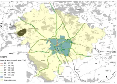
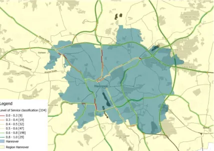
between 04:00 pm to 06:00 pm seems to be regularly affected by a very high traffic demand and low speeds. Fig. 5 and 6 exemplifies a LOS map of the test site for the last mentioned time interval on a typical Thursday of the year 2012. Having a closer look on the road network, one can state that mainly roads that connect the intraurban districts with the outer high capacity road network seem to be affected by traffic jams and low driving speeds. All in all LOS maps like this allows a regular and systematic identification of bottlenecks in road networks. Furthermore, the derived driving speeds could be used to evaluate effects of modified signalized intersection.
5.Conclusion and need for further research
The paper demonstrates that the developed fourth stage concept could be applied successfully for the road network of Hanover and the surrounding area. The realized methodology allows road authorities a representative, driving speeds related estimation of LOS for large road networks based on FCD and with respect to the geographical referencing system used in the TMC-system (Traffic Message Channel). A great advantage of the developed concept is the free and therefor cost-neutral usage of digital map data from OpenStreetMap. Further need for research could be finally seen in the optimization of a fully-automatic TMC-segments generation when working with OpenStreetMap data. Further, it will be necessary to calibrate and validate the derived LOS based on local video observations or alternative measurement techniques like automatic number plate recognition.
Table 1 Level of service allocation Level of service gij,t
A ≥ 0.8 B ≥ 0.6 C ≥ 0.5 D ≥ 0.4 E ≥ 0.3 F < 0.3
Fig. 4 Average speed in network - non motorways
Fig. 5 Level of service for the Region at a typical Thu 2012 at 04:00 pm - 06:00 pm 55 60 65 70 75 80 0 2 4 6 8 10 12 14 16 18 20 22 av er ag e n et w or k sp eed [ km /h ] Time of day
Mon Tue Wen Thu
Fig. 6 Level of service for Hanover City at a typical Thu 2012 at 04:00 pm - 06:00 pm
References
Brilon, W. and Schnabel, W. (2003): Bewertung der Qualität des Verkehrsablaufs auf Hauptverkehrsstraßen. in: Straßenverkehrstechnik (1.2003).Kirschbaum Verlag GmbH, Bonn, Germany.
Ehmke, J. F., & Mattfeld, D. C. (2010). Data allocation and application for time-dependent vehicle routing in city logistics.
Lorkowski, S., Mieth, P., & Schäfer, R. P. (2005, December). New ITS applications for metropolitan areas based on Floating Car Data. In ECTRI Young Researcher Seminar, Den Haag.
Lou, Y., Zhang, C., Zheng, Y., Xie, X., Wang, W., & Huang, Y. (2009, November). Map-matching for low-sampling-rate GPS trajectories. InProceedings of the 17th ACM SIGSPATIAL International Conference on Advances in Geographic Information Systems (pp. 352-361). ACM.
Lyman, K. and Bertini L. (2008): Using travel time reliability measures to improve regional transportation planning and operations. Transportation Research Record: Journal of the Transportation Research Board 2046.1 (2008): 1-10.
Modsching, M., Kramer, R., & ten Hagen, K. (2006, March). Field trial on GPS Accuracy in a medium size city: The influence of built-up. In 3rd Workshop on Positioning, Navigation and Communication (pp. 209-218).
OpenStreetMap (2013).http://www.openstreetmap.org Map data by OpenStreetMap, under CC-BY-SA.
Rahmani, M., Jenelius, E., & Koutsopoulos, H. N. (2013). Route travel time estimation using low-frequency floating car data. In Proceedings of the 16th International IEEE Annual Conference on Intelligent Transportation Systems.
Schäfer, R. P., Thiessenhusen, K. U., & Wagner, P. (2002, October). A traffic information system by means of real-time floating-car data. In ITS world congress (Vol. 2).