I N H U M A N E N V I R O N M E N T S
D I S S E R TAT I O N
zur Erlangung des Doktorgrades (Dr. rer. nat.)
der Mathematisch-Naturwissenschaftlichen Fakultät
der Rheinischen Friedrich-Wilhelms-Universität Bonn
vorgelegt von
s t e f a n o ß wa l d
aus Lörrach
Mathematisch-Naturwissenschaftlichen Fakultät der Rheinischen Friedrich-Wilhelms-Universität Bonn
Erste Gutachterin: Prof. Dr. Maren Bennewitz
Rheinische Friedrich-Wilhelms-Universität Bonn Zweiter Gutachter: Prof. Dr. Wolfram Burgard
Albert-Ludwigs-Universität Freiburg Tag der Promotion: 6. November2018
For the near future, we envision service robots that will help us with everyday chores in home, office, and urban environments. In contrast to industrial applications, these robots need to work in environments that were designed for humans and they have to collaborate with humans to fulfill their tasks. In this thesis, we propose new methods for communicating, transferring knowledge, and collaborating between humans and robots in four different navigation tasks.
In the first application, we investigate how automated services for giving wayfinding directions can be improved to better address the needs of the human recipients. Route descriptions can contain sev-eral different types of information such as metric distances, cardinal directions, egocentric headings, or landmarks of various categories. Which information is most valuable depends on the recipient, for example street names are hardly of use for visually impaired persons as they cannot see the street signs. We propose a novel method based on inverse reinforcement learning that learns from a corpus of hu-man-written route descriptions what amount and type of information a route description should contain. By imitating the human teachers’ description style, our algorithm produces new route descriptions that sound similarly natural and convey similar information content as the human teachers do as we show in a user study.
In the second application, we investigate how robots can leverage background information provided by humans for exploring an un-known environment more efficiently. Typically, the first task of any mobile robot is to explore its surroundings for generating a map us-ing a Simultaneous Localization and Mappus-ing (SLAM) approach. The robot later uses this map for planning navigation tasks. In many cases, background information such as a floor plan of the building or a sketch provided by the user is available. We propose an algorithm for exploiting such background information given as a topo-metric graph by combining a global exploration strategy based on the solu-tion of a traveling salesman problem with a local nearest-frontier-first exploration scheme. Our simulation experiments in both artificial and real-world environments show that the exploration tours are signifi-cantly shorter and that our system allows the user to effectively select the areas that the robot should explore. We show that the approach is robust against noise and errors in the provided graph.
In the second part of this thesis, we focus on humanoid robots in home and office environments. The human-like body plan allows humanoid robots to navigate in environments and operate tools that were designed for humans, for example to step across obstacles, climb
able for a wide range of applications. As localization and mapping are prerequisites for all navigation tasks, we first introduce a novel feature descriptor for RGB-Dsensor data and integrate this building block into an appearance-basedSLAMsystem that we adapt and optimize for the usage on humanoid robots. Our real-world experiments show that our optimized system is able to track a Nao humanoid robot more accurately and more robustly than existing approaches.
As the third application, we investigate how humanoid robots can cover known environments efficiently with their camera, for example for inspection or search tasks. We extend an existing next-best-view approach based on sampled raycasting by integrating the concept of inverse reachability maps. Pre-recording an inverse reachability map for a humanoid robot allows us to efficiently sample and check collision-free full-body poses so that the algorithm can take the full body pose into account already when sampling camera poses from where large portions of the environment are visible. Our approach enables the robot to bend over boxes and peak behind and below objects to inspect as much of the environment as possible.
In our fourth application, we extend the coverage scenario to en-vironments that also include articulated objects that the robot has to actively manipulate to see behind them, for example to open a cupboard for investigating its contents. Introducing articulated objects increases the complexity for computing a coverage tour even further, demanding efficient approaches for navigation and camera pose sam-pling. Hence, we introduce algorithms for the computation of cost maps and utility maps and for estimating the information gain of a camera view pose that run highly parallelized on graphics process-ing units for embedded devices. Together with a novel heuristic for estimating utility maps, our system allows to find high-utility camera poses for efficiently covering environments with articulated objects.
All techniques presented in this thesis were implemented in software and thoroughly evaluated in user studies, simulations, and experi-ments in both artificial and real-world environexperi-ments. Our approaches advance the state of the art towards universally usable robots in every-day environments.
In naher Zukunft erwarten wir Serviceroboter, die uns im Haushalt, im Büro und in der Stadt alltägliche Arbeiten abnehmen. Im Gegensatz zu industriellen Anwendungen müssen sich diese Roboter in Umgebun-gen zurechtfinden, die für Menschen gebaut wurden, und sie müssen mit den Menschen zusammenarbeiten um ihre Aufgaben erledigen zu können. In dieser Arbeit schlagen wir neue Methoden für die Kommu-nikation, Wissenstransfer und Zusammenarbeit zwischen Menschen und Robotern bei Navigationsaufgaben in vier Anwendungen vor.
In der ersten Anwendung untersuchen wir, wie automatisierte Dienste zur Generierung von Wegbeschreibungen verbessert werden können, um die Wegbeschreibungen besser an die Bedürfnisse der Empfänger anzupassen. Wegbeschreibungen können mehrere verschie-dene Arten von Informationen enthalten, beispielsweise metrische Distanzen, Himmelsrichtungen, egozentrische Richtungsangaben oder Landmarken unterschiedlicher Kategorien. Welche Information für den Empfänger am wertvollsten ist, hängt von der Situation und dem Empfänger ab, beispielsweise sind Straßennamen kaum von Nutzen für sehbehinderte Menschen, die keine Straßenschilder lesen können. Wir schlagen eine neue Methode vor, die inverses bestärkendes Lernen nutzt, um aus einem Korpus von von Menschen geschriebenen Weg-beschreibungen zu lernen, wie viel und welche Art von Information eine Wegbeschreibung enthalten sollte. Indem unser Algorithmus den Stil der Wegbeschreibungen der menschlichen Lehrer imitiert, kann der Algorithmus neue Wegbeschreibungen erzeugen, die sich ähnlich natürlich anhören und einen ähnlichen Informationsgehalt vermitteln, wie wir in einer Benutzerstudie zeigen.
In der zweiten Anwendung untersuchen wir, wie Roboter von Men-schen bereitgestellte Hintergrundinformationen ausnutzen können, um eine bisher unbekannte Umgebung schneller zu erkunden. Die erste Aufgabe eines mobilen Roboters besteht in der Regel darin, sei-ne Umgebung zu erkunden um eisei-ne Karte mit eisei-nem simultasei-nen Lokalisierungs- und Kartierungsverfahren (SLAM) zu erstellen, die der Roboter später zur Planung von Navigationsaufgaben nutzen kann. Oftmals stehen Hintergrundinformationen zur Verfügung, bei-spielsweise Gebäudegrundrisse oder von einem Benutzer gezeichnete Skizzen. Wir schlagen einen Algorithmus vor, der solche Hintergrund-informationen in Form eines topometrischen Graphen nutzt, indem er eine globale Explorationsstrategie basierend auf der Lösung eines Problems des Handlungsreisenden kombiniert mit einer lokalen Ex-plorationsstrategie, welche die nächstliegende noch nicht explorierte Grenze zwischen Freifläche und noch unbekanntem Gebiet als
realen Umgebungen zeigen, dass die Erkundungstouren signifikant kürzer werden und dass unser System dem Benutzer eine effektive Möglichkeit bietet, die Regionen zu spezifizieren, die der Roboter erkunden soll. Wir zeigen, dass der Ansatz robust ist gegenüber Un-genauigkeiten und Fehlern in dem zur Verfügung gestellten Graphen. Im zweiten Teil dieser Arbeit legen wir den Fokus auf humanoide Roboter in Umgebungen zuhause und im Büro. Der menschenähnliche Körperbau ermöglicht es humanoiden Robotern, in Umgebungen zu navigieren und Werkzeuge zu benutzen, die für Menschen gebaut wurden. Humanoide Roboter können zum Beispiel über Hindernisse steigen, Treppen steigen oder Schranktüren und Schubladen öffnen, wodurch humanoide Roboter für eine große Bandbreite an Aufga-ben eingesetzt werden können. Da Lokalisierung und Kartierung Grundvoraussetzungen für alle Navigationsaufgaben sind, führen wir zunächst einen neuen Merkmalsdeskriptor fürRGB-D -Sensorda-ten ein und integrieren diesen Baustein in ein erscheinungsbasiertes SLAM-System, das wir an die Besonderheiten von humanoiden Robo-tern anpassen und optimieren. Unsere Experimente in einer realen Umgebung zeigen, dass unser optimiertes System in der Lage ist, die Position eines humanoiden Roboters genauer und robuster zu verfolgen als es mit existierenden Ansätzen möglich ist.
Als dritte Anwendung untersuchen wir, wie humanoide Roboter bekannte Umgebungen effizient mit ihrer Kamera abdecken können, beispielsweise zu Wartungs- und Inspektionszwecken oder zum Su-chen eines Gegenstands. Wir erweitern ein bestehendes Verfahren, das mithilfe von Raycasting zufällig gezogener Strahlen die nächstbeste Beobachtungsposition berechnet, indem wir das Konzept von inversen Erreichbarkeitskarten integrieren. Das Vorberechnen einer inversen Erreichbarkeitskarte für einen humanoiden Roboter ermöglicht es, kol-lisionsfreie Ganzkörperposen effizient zu generieren und zu prüfen. Dadurch kann der Algorithmus Ganzkörperposen bereits berücksich-tigen, wenn er Beobachtungspunkte in der Umgebung bestimmt, von denen aus große Teile der Umgebung sichtbar sind. Unser Ansatz ermöglicht es dem Roboter, sich über Kisten zu beugen und hinter und unter Objekte zu schauen um so viel wie möglich von der Umgebung zu untersuchen.
In unserer vierten Anwendung erweitern wir dieses Szenario be-züglich Umgebungen, die auch bewegbare Gegenstände enthalten, sodass der Roboter aktiv Objekte bewegen muss um hinter das Objekt zu sehen, beispielsweise einen Schrank zu öffnen um den Inhalt zu inspizieren. Bewegliche Gegenstände einzuführen erhöht die Komple-xität des Problems eine Inspektionstour zu planen erheblich, wodurch effiziente Ansätze für die Navigation und das Bestimmen der Beob-achtungspunkte notwendig werden. Daher führen wir Algorithmen für die Berechnung von Kosten- und Nutzenkarten und die Schätzung
werden. Zusammen mit einer neuen Heuristik zur Schätzung von Nut-zenkarten ermöglicht dies unserem System Beobachtungspunkte mit hohem Nutzen zu finden, um Umgebungen mit bewegbaren Objekten effizient zu inspizieren.
Die vorgestellten Techniken wurden in Software implementiert und sorgfältig evaluiert in Benutzerstudien, Simulationen und Experimen-ten sowohl mit künstlichen als auch mit realen Umgebungen. Unsere Verfahren bringen den Stand der Forschung voran in Richtung univer-sell einsetzbarer Roboter in alltäglichen Umgebungen.
On my journey as a PhD student, I met many people who taught, encouraged, and supported me and I would like to express my deepest thanks to them. First of all, I would like to thank Maren Bennewitz, Cyrill Stachniss, and Wolfram Burgard for giving me the opportu-nity to work in their labs and for supervising and counseling me throughout my studies. Their experience guided my research and they sparked my interest in robotics. I would also like to thank Olivier Stasse for giving me the opportunity of a research internship at the Gepetto team at LAAS-CNRS in Toulouse, it was a great experience and gave me many new ideas.
Many thanks to Armin Hornung for supervising me during my Bachelor and Master studies. I learned a lot from him and he prepared me well for life as a PhD student.
I would like to thank my colleagues and fellow students at the Universities of Freiburg and Bonn, at LAAS-CNRS, and my colleagues from the SFB/TR-8in Bremen for their support and friendship.
For their contributions on our collaborative projects and research, I thank my co-authors Henrik Kretzschmar, Rasha Sheikh, Philipp Karkowski, Peter Regier, and Christian Dornhege.
Thanks to Philipp Karkowski and Rasha Sheikh for proof-reading earlier versions of this thesis.
Finally and most importantly, my deepest thanks go to my family who always encourage and support me.
The work on this thesis has been generously supported by the German Research Foundation (DFG) under contract number SFB/TR-8“Spatial Cognition” and by the European Commission under contract number FP7-ICT-600890-ROVINA.
1 i n t r o d u c t i o n 1 1.1 Key contributions . . . 5 1.2 Publications . . . 5 1.3 Collaborations . . . 7 1.4 Notation . . . 8 2 l e a r n i n g t o g i v e r o u t e d i r e c t i o n s f r o m h u m a n d e m o n s t r at i o n s 9 2.1 Introduction . . . 9 2.2 Related work . . . 11
2.3 Learning to give directions for routes from human demonstrations . . . 14
2.3.1 Giving directions as a reinforcement learning problem . . . 14
2.3.2 Maximum entropy inverse reinforcement learning 17 2.3.3 Features . . . 19
2.3.4 Contexts . . . 23
2.4 Experimental evaluation . . . 24
2.4.1 Acquiring training data . . . 24
2.4.2 Learned policies . . . 26
2.4.3 Experimental setup for evaluating the generated descriptions . . . 28
2.4.4 How human-like are the directions generated by our approach? . . . 29 2.5 Discussion . . . 32 2.6 Conclusions . . . 33 3 s p e e d i n g-u p m o b i l e r o b o t e x p l o r at i o n u s i n g b a c k g r o u n d k n o w l e d g e 35 3.1 Introduction . . . 35 3.2 Related work . . . 38
3.3 Guiding exploration with background knowledge . . . 40
3.3.1 Representation of background information about the environment . . . 40
3.3.2 Representation of the exploration problem . . . 40
3.3.3 Solving the TSP . . . 41
3.3.4 Frontier-based exploration exploiting the TSP solution . . . 42 3.3.5 Re-planning . . . 44 3.4 Experimental evaluation . . . 46 3.4.1 Environments . . . 46 3.4.2 Background information . . . 49 xv
3.4.3 Traveled distance . . . 50
3.4.4 Run time . . . 51
3.4.5 Robustness . . . 51
3.4.6 Influence of information gain . . . 53
3.5 Discussion . . . 54 3.6 Conclusions . . . 54 4 s l a m f o r h u m a n o i d s w i t h a c o m b i n e d r g b a n d d e p t h d e s c r i p t o r 57 4.1 Introduction . . . 57 4.2 Related work . . . 61 4.2.1 RGB-D SLAM . . . 61
4.2.2 Appearance-based loop closing . . . 61
4.2.3 SLAM and visual odometry for humanoid robots 62 4.3 Proposed RGB-D feature descriptor . . . 62
4.4 Appearance-based SLAM . . . 65
4.4.1 Pose tracking . . . 66
4.4.2 Mapping . . . 68
4.4.3 Place recognition for loop closing . . . 69
4.5 Experimental evaluation . . . 70
4.5.1 Evaluation of descriptors . . . 71
4.5.2 Place recognition . . . 74
4.5.3 Simultaneous localization and mapping . . . 75
4.5.4 Computational cost . . . 77 4.6 Discussion . . . 78 4.7 Conclusions . . . 79 5 e f f i c i e n t c ov e r a g e o f 3 d e n v i r o n m e n t s w i t h h u -m a n o i d r o b o t s u s i n g i n v e r s e r e a c h a b i l i t y -m a p s 81 5.1 Introduction . . . 81 5.2 Related work . . . 84
5.3 Problem description and framework . . . 85
5.4 Reachability map and pose evaluation . . . 86
5.5 Efficient representation of the IRM . . . 89
5.6 Planning a tour of viewing poses . . . 91
5.6.1 Sampling candidate viewing poses . . . 91
5.6.2 Determining whole-body configurations . . . . 92
5.6.3 Formulation as a traveling salesman problem . 93 5.7 Experiments . . . 94
5.7.1 Generating the inverse reachability map . . . . 94
5.7.2 Coverage of simulated environments . . . 94
5.7.3 Coverage of a real scene . . . 98
5.8 Discussion . . . 98
6 g p u-a c c e l e r at e d n e x t-b e s t-v i e w e x p l o r at i o n o f a r t i c u l at e d s c e n e s 101 6.1 Introduction . . . 101 6.2 Related work . . . 103 6.3 Problem formulation . . . 105 6.4 GPU algorithms . . . 106
6.4.1 Properties of the graphics pipeline . . . 106
6.4.2 Cost map computation . . . 107
6.4.3 Single-source shortest path . . . 108
6.4.4 Information gain computation . . . 112
6.4.5 Estimating the utility map . . . 112
6.4.6 Covering environments with a robot’s camera . 115 6.5 Experimental evaluation . . . 116
6.5.1 Benchmarking the GPU algorithms . . . 116
6.5.2 Information gain map estimation . . . 119
6.5.3 Covering environments with a robot’s camera . 120 6.6 Discussion . . . 120
6.7 Conclusions . . . 121
7 c o n c l u s i o n s 123 a a p p e n d i x 127 a.1 Nao humanoid robot: Technical data . . . 127 a.2 ASUS Xtion Pro Live RGB-D camera: Technical data . 128
l i s t o f f i g u r e s 129
l i s t o f ta b l e s 131
l i s t o f a l g o r i t h m s 132
a c r o n y m s 133
1
I N T R O D U C T I O NRobots are about to step into our daily lives: Vacuum cleaner robots and autonomous lawn mowers have already conquered many homes, robots work as concierges in hotels, as servers in restaurants, and as tour guides in museums, they park our cars in automated garages or even drive cars themselves. For the future, we envision robots to become indispensable companions and everyday tools in business, education, entertainment, and public services much like the devel-opment of personal computers has revolutionized many domains of our lives. We believe that humans and robots will make great teams — not because of their similarities, but because of their differences that complement each other. Humans have creativity, intuition, emotions, and broad background knowledge that allows them to adapt to new environments and situations on a daily basis. Robots can process vast amounts of data, they are patient and persevering, and they can be designed to be strong, fast, and precise. Combining their strengths, humans and robots can unlock synergies to achieve higher produc-tivity and higher standards of living. To leverage the full potential of this human-robot collaboration, humans and robots need to work closely together by sharing common workspaces, using the same fa-cilities and tools, and communicating naturally and intuitively about tasks and observations. In this thesis, we present novel approaches for reaching these goals for successful human-robot collaboration in everyday navigation tasks.
In recent years, technology for mobile and humanoid robots has evolved rapidly: The availability of lightweight and energy-efficient RGB-D cameras has improved the robots’ sensing capabilities. Com-bined with fast map representation techniques such as OctoMaps [75], a large toolbox of point cloud processing techniques collected in the open source Point Cloud Library (PCL) [147], and advances in 3D Simultaneous Localization and Mapping (SLAM) techniques, these sensors allow robots to map and navigate complex environments. Ad-vances in neural networks and deep learning techniques [137] together with the increasing availability of dedicated parallel computing de-vices have opened up new opportunities for computer vision and scene understanding that allow a robot to act in domestic environments. Progress in the area of natural language processing and generation allows for a more natural interaction and communication between humans and robots. With the Robot Operating System (ROS), these advances in technology have been made accessible for research teams world-wide, fostering development in the whole field of robotics.
(a) Cosero (b) Nao cleaning up (c) Pepper tour bot Figure1.1: Robots acting in human environments. (a): University of Bonn’s
Cosero opening a fridge to investigate its contents (source: [169]). (b): Our Nao robot cleaning up a children’s room as part of the SQUIRREL project (source: [158]). (c): Pepper robot providing an interactive tour of a lab at Queensland University (source: [166]).
This progress in developing general-purpose robots for daily appli-cations is particularly visible in the RoboCup@Home championship. The RoboCup@Home championship puts emphasis on two aspects: First, the scenarios for the challenges are set up in everyday environ-ments such as homes, offices, supermarkets, or restaurants that are unknown to the robots and the developers before the competition. In contrast to the RoboCup Soccer championship or industrial ap-plications, RoboCup@Home does not abstract the environments or tailor the environments to the needs of robots, for example by adding fiducials. As “uncertainty is part of the concept” [15], the robots have to deal with human environments that they have to understand and manipulate.
Second, large parts of the RoboCup@Home challenge focus on human-robot interaction, for example thecocktail partytask where a robot has to serve drinks to previously unknown people, or thehelp
me carrytask where a robot has to cooperate with a human operator
by following the person and executing voice commands. Natural interaction is key for the success of domestic robots, as untrained persons have to be able to work with and command the robots without having any programming skills.
In this thesis, we explore how humans and robots can collaborate to solve navigation tasks in human environments by leveraging syn-ergies in four different scenarios. In the first application (Chapter 2), we investigate how humans and automated computer systems can join forces to create better route descriptions. Wayfinding is a task that we face every day, for example when we travel to an unknown city or when we describe how to reach the train station to a foreign visitor. While we already often rely on technical devices such asGPS navigation devices or web-based routing services, these automated systems do not speak our language: Automated routing services typi-cally produce phrases like “Turn left after 250 m” even though metric
distances are rather difficult to estimate for humans, making the route descriptions hard to follow. If you ask a random passer-by how to get to the train station, they will rather refer to salient landmarks that they choose depending on the recipient: Which landmarks catch someone’s attention is different for children and adults, locals and non-locals, or blind and sighted people. Hence, we propose to combine the strengths of humans and automated systems: Humans know the target audience and have an intuition about what types of information are most useful for the person receiving the description, but on the other hand, they frequently make mistakes such as confusing left and right, miscount-ing intersections, and inaccurately estimatmiscount-ing distances. Computer systems, by contrast, have access to a large amount of information such as an accurate, detailed map, but they are bad at judging what information is “ergonomic” for the recipient. The core idea of our approach is that automated systems should learn from humans how to describe routes: From a corpus of descriptions written by humans for a specific audience, our algorithm learns how much and what type of information it should include in a route description. Afterwards, the algorithm uses the learned policy to create new route descriptions that are correct and complete according to the map data, but also easy to understand and useful for the targeted audience.
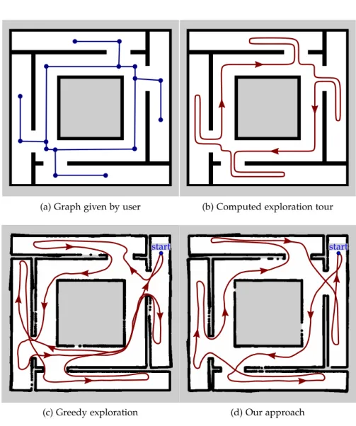
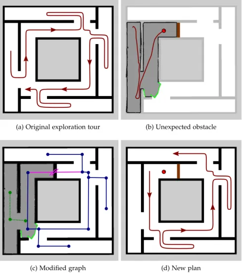
In this first application, we investigate how automated systems can communicate navigation strategies to humans in a natural way. In the second application (Chapter3), we consider the opposite scenario: How can humans effectively communicate background knowledge to a robot to help the robot better navigate in an unknown environment? The prerequisite for robot navigation is an accurate representation of the environment. In most scenarios considered in the literature, robots start with zero knowledge about the environment and use a SLAM approach to build an environment model from scratch following an exploration strategy that determines which areas will be explored next. If the robot does not have access to any background information, the decision on which area to explore next can lead to an arbitrarily ineffi-cient exploration behavior. In many cases, however, some background information about the environment would be available, for example a sketch drawn by a human operator or a floor plan showing the basic building layout. We propose an algorithm to make background infor-mation from sources like these available to the robot and investigate how the robot can exploit this information to optimize the exploration tour, leading to shorter exploration times. We show an application where our algorithm uses data generated from archeological sketch maps to compute efficient navigation strategies for exploring a historic Roman catacomb.
While Chapters2 and 3target the communication aspect of navi-gating in human environments, the remaining chapters focus on the question of how robots can navigate in environments that are tailored
to humans. As we work towards universally usable robots working in everyday environments, these environments can hardly be modified to suit the needs of robots. In contrast to industrial environments, for example, it would be impractical to fit homes, shops, and even whole cities with induction loops or reflective fiducials that robots can use to navigate. Hence, robots have to use the environment itself to localize and navigate. In continuation of our previous work on robot navigation based on visual floor features [126], recognizing staircases in laser scans [128], and fine-positioning on staircases based on edge features [127,129], we present a new feature descriptor forRGB-Ddata in Chapter 4and optimize an existing appearance-based SLAMsystem for the usage in humanoid robots. Robust localization and mapping is a prerequisite for robots that execute tasks for humans in their homes.
One example for such a task is to search for an object in a known environment, for example to look for the car keys in an apartment. In Chapters5and6, we consider the task of covering a known environ-ment with a robot’s camera, for example for mapping, inspection, or search tasks in user-defined regions of the environment. We extend an approach that Dornhege et al. [40, 41] originally developed for locating trapped persons in disaster rescue scenarios to make the tech-nique usable on humanoid robots. In contrast to wheeled or tracked platforms, humanoid robots are better suited for human environments because they have a similar body plan as humans and can thus better use facilities and tools designed for humans. They can, for example, climb stairs, bend over boxes, crouch down to peek under objects, or open doors to see inside cupboards. The higher dexterity and degrees of freedom, however, come with higher planning complexity. In par-ticular, bipedal robots have to maintain their balance while moving, introducing many constraints in the planning space, making sampling-based planning techniques as used in Dornhege’s original approach infeasible. Hence, we introduce inverse reachability maps into the framework which allows us to quickly enumerate and verify stable body poses already in the camera viewpoint planning phase so that our algorithm generates coverage plans that are feasible, flexible, and efficient in static scenes.
As we envision our robots to help us with daily chores, the robots will also have to manipulatearticulatedobjects, for example open draw-ers and cupboards or moving obstacles aside. Hence, we introduce articulated objects into our coverage planning scenario in Chapter6. In addition to the high-dimensional planning problem of planning full-body poses, the robot now also has to decide in which order to manipulate multiple objects, for example when opening drawers and doors of a kitchenette that might occlude each other, increasing the planning complexity further. In order to be able to determine regions visible from the robot’s perspective for a substantial amount of articu-lation configurations, we formulate the path planning and visibility
determination subproblems as rendering problems and use Graphics Processing Unit (GPU) acceleration to speed up the computation. In contrast to existing approaches that use dedicated high-end comput-ing devices, we only use features available in the embedded systems subset of the Open Graphics Library (OpenGL) standard and show that the algorithm runs efficiently on a smartphone. In combination with a novel heuristic for estimating utility maps, our algorithm generates efficient plans for covering a known environment, which includes manipulating objects to gain access to hidden regions.
In Chapter7, we summarize the results of this thesis and discuss open questions for future research.
1.1 k e y c o n t r i b u t i o n s
In this thesis, we investigate several aspects of human-robot collabora-tion and robot navigacollabora-tion in environments designed for humans. In summary, our key scientific contributions are:
• an inverse reinforcement learning approach for learning how to describe routes from a corpus of human-written route descrip-tions (Chapter 2),
• a planning approach that exploits background information given by the user to create an efficient exploration strategy for explor-ing unknown environments (Chapter3),
• a feature descriptor that combinesRGB and depth information for the usage in appearance-basedSLAM systems on humanoid robots (Chapter 4),
• an approach that combines an existing next-best-view approach for planning a coverage tour through a known environment with inverse reachability maps for generating full-body poses for a humanoid robot (Chapter5), and
• a heuristic and techniques leveraging GPUs to compute utility maps for covering known environments that contain also articu-lated objects (Chapter6).
1.2 p u b l i c at i o n s
Parts of this thesis have been published in international journals and conference proceedings. The following list gives an overview about the individual publications.
• Chapter2:
S. Oßwald, H. Kretzschmar, W. Burgard, and C. Stachniss. “Learning to give route directions from human demonstra-tions.” In:Proc. of the IEEE Int. Conf. on Robotics & Automa-tion (ICRA).2014, pp.3303–3308.
doi:10.1109/ICRA.2014.6907334.
Best Cognitive Robotics Paper–Finalist. • Chapter3:
S. Oßwald, M. Bennewitz, W. Burgard, and C. Stach-niss. “Speeding-up robot exploration by exploiting back-ground information.” In:IEEE Robotics and Automation Let-ters (RA-L)1.2(2016), pp.716–723.issn:2377-3766.
doi:10.1109/LRA.2016.2520560.
• Chapter4:
R. Sheikh, S. Oßwald, and M. Bennewitz. “A combined RGB and depth descriptor for SLAM with humanoids.” In: Proc. of the IEEE/RSJ Int. Conf. on Intelligent Robots & Systems (IROS). In press.2018.
• Chapter5:
S. Oßwald, P. Karkowski, and M. Bennewitz. “Efficient coverage of3D environments with humanoid robots using inverse reachability maps.” In: Proc. of the IEEE-RAS Int. Conf. on Humanoid Robots (Humanoids).2017, pp.151–157.
doi:10.1109/humanoids.2017.8239550.
• Chapter6:
S. Oßwald and M. Bennewitz. “GPU-accelerated next-best-view coverage of articulated scenes.” In: Proc. of the IEEE/RSJ Int. Conf. on Intelligent Robots & Systems (IROS). In press.2018.
The following publications were written while employed as a research assistant, but are not covered by this thesis:
• S. Oßwald, A. Hornung, and M. Bennewitz. “Improved proposals for highly accurate localization using range and vision data.” In:Proc. of the IEEE/RSJ Int. Conf. on Intelligent Robots & Systems (IROS).2012, pp.1809–1814.
doi:10.1109/IROS.2012.6385657.
• A. Hornung, S. Oßwald, D. Maier, and M. Bennewitz. “Monte Carlo localization for humanoid robot navigation in complex indoor environments.” In: Int. Journal of Hu-manoid Robotics11.2(2014).
• P. Regier, S. Oßwald, P. Karkowski, and M. Bennewitz. “Foresighted navigation through cluttered environments.” In: Proc. of the IEEE/RSJ Int. Conf. on Intelligent Robots & Systems (IROS).2016, pp.1437–1442.
doi:10.1109/IROS.2016.7759234.
• P. Karkowski, S. Oßwald, and M. Bennewitz. “Real-time footstep planning in 3D environments.” In: Proc. of the
IEEE-RAS Int. Conf. on Humanoid Robots (Humanoids).2016, pp.69–74.
doi:10.1109/HUMANOIDS.2016.7803256.
1.3 c o l l a b o r at i o n s
Parts of this thesis are the results of collaborative work with other researchers, hence we consistently use “we” within this thesis. The collaborations on the work in this thesis and my contributions are as follows:
• Chapter2: The system for learning to give route directions was developed in collaboration with Henrik Kretzschmar and su-pervised by Cyrill Stachniss and Wolfram Burgard. I designed and implemented the system. Henrik Kretzschmar contributed knowledge and experience about the general inverse reinforce-ment learning approach. I designed, executed, and evaluated the experiments jointly with Henrik Kretzschmar.
• Chapter3: The development of the system for robot exploration with background knowledge was supervised by Cyrill Stachniss and data for the experiments has been provided by the ROVINA project.
• Chapter4: The combined depth andRGBdescriptor was origi-nally developed within the Master’s thesis of Rasha Sheikh. The design, implementation, and evaluation of the system was done entirely by Rasha Sheikh. I developed the project idea, super-vised and adsuper-vised the work on her thesis. We jointly executed the real-world experiments.
• Chapter5: The system for covering3D environments with hu-manoid robots was developed as an extension of Christian Dorn-hege’s framework [41] in collaboration with Philipp Karkowski and was supervised by Maren Bennewitz. Philipp Karkowski contributed the design and implementation of the method for systematic sampling of rays described in Section5.6.1.
• Chapter6: The work onGPU-accelerated coverage tour planning was supervised by Maren Bennewitz.
1.4 n o tat i o n
We will use the following notation throughout this work:
Symbol Description
a,b, . . . scalar value
x,y, . . . vector
A,B, . . . matrix
xT,AT transpose of a vector or a matrix
kxk norm (length) of a vector
det(A) determinant of a matrix
[a,b] continuous range includingaandb
S={s1,s2, . . .} set
|S| cardinality (number of elements) of a set
S\T set subtraction
x←a assignment of valueato a variablex
p(x) probability distribution of a random variablex
p(x|y) conditional probability ofxgiveny
E[X] expectation value of random variableX
1a=b indicator function, returns 1 ifa =band 0 otherwise
˜
a empirical value from training data
a∨b logical disjunction (OR operation)
a∧b logical conjunction (AND operation)
2
L E A R N I N G T O G I V E R O U T E D I R E C T I O N SF R O M H U M A N D E M O N S T R AT I O N S
For several applications, robots and other computer systems must provide route descriptions to humans. These descriptions should be natural and intuitive for the human users. In this chapter, we present an algorithm that learns how to provide good route descrip-tions from a corpus of human-written direcdescrip-tions. Using inverse reinforcement learning, our algorithm learns how to select the in-formation for the description depending on the context of the route segment. The algorithm then uses the learned policy to generate directions that imitate the style of the descriptions provided by humans, thus taking into account personal as well as cultural preferences and special requirements of the particular user group providing the learning demonstrations. We evaluate our approach in a user study and show that the directions generated by our policy sound similar to human-given directions and substantially more natural than directions provided by commercial web services.
2.1 i n t r o d u c t i o n
Providing and following route directions is a task we face on a daily basis, for example when asking staff members how to get to the right aisle in a library or shopping center, or when moving in an unknown city following instructions provided by a navigation device. When driving cars, we already rely on web services such as Google Maps [61] and satellite navigation systems that provide turn-by-turn instructions at every decision point. For some applications, however, giving turn-by-turn instructions in real-time is impractical or impos-sible, for example in indoor navigation where global positioning is not available. In such applications, computer systems should be able to give spoken directions of the complete route in advance. This is relevant for information kiosks in public buildings, tour guide robots in museums, or navigation devices for visually impaired persons who are unable to read maps.
Existing commercial web services typically follow rigid patterns for giving directions, usually referring to the metrical distance to the forthcoming turning and the name of the street that the user has to take, e.g., “Turn left after 267 m onto Market Street.” While these descriptions are technically correct, precise, and complete, they are still hard to follow for human users and they do not resemble the directions a human would give. Instead of providing precise metric
information, humans usually refer to salient landmarks along the route [177], trade off the amount of information that the recipient requires against the memory load caused by long descriptions, and take into account personal and cultural preferences when giving route directions [77].
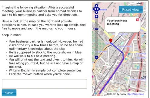
The goal of this work is to develop a system that gives route di-rections in spoken or written form that humans can naturally and intuitively understand. We propose an approach that learns how to generate route descriptions from a corpus of human-generated de-scriptions. In this way, the user can train our system to use a particular style of instructions that is appropriate for the use case at hand. One of the key challenges is to choose the right amount and type of informa-tion that a route descripinforma-tion should contain. What constitutes a “good” description depends on the user and the situation. Street names, for instance, are hardly of use for visually impaired, blind, or illiterate recipients as they cannot read the corresponding street signs. Street names are also challenging for foreigners who cannot decipher street signs written in Cyrillic, Arabic, or other scripts unknown to them. For blind recipients, tactile pavements and audible cues are much better suited description elements. By imitating the style of existing descriptions written for a particular user group, our system can learn to choose the type of information that best suits the needs of the users.
The person giving the directions also has to trade off the amount of information to give to the recipient. More detailed or even redundant descriptions may help the user to resolve ambiguities and recover from errors, but on the other hand require more memory and are thus harder to remember. As mentioned above, Hund et al. [77] found in a user study that cultural backgrounds influence the style of route directions. Participants from the United States who are accustomed to the typical grid-like layout of US cities with numbered streets would be more aware of street names and cardinal directions and use these elements when giving directions. Participants from the Netherlands, by contrast, would use these elements less, as the cities they are familiar with are typically irregular without any systematic street name scheme. They would instead refer to landmarks such as rivers, bridges, railroad crossings, and salient buildings.
Many other factors influence the decision of which ingredients to choose for composing a route description, such as personal pref-erences, the environment, familiarity of the recipient with the city, available tools such as sketches or maps, and the situation in which the description is given. Designing a rule-based expert system that takes all these factors into account is infeasible. Hence, we propose an adaptive system that can be trained to generate route descriptions tailored to a particular situation and audience by imitating the style of descriptions of a corpus of human-written descriptions.
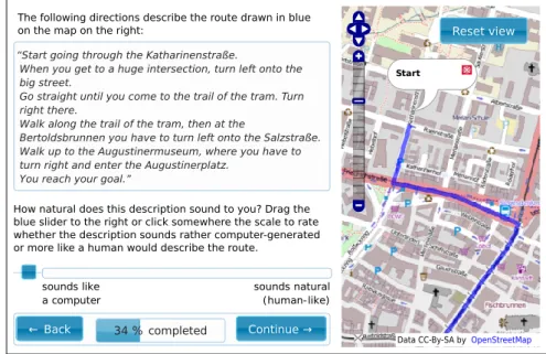
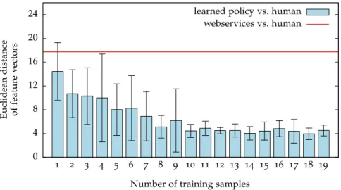
The contribution of this work is a novel approach to learn a model of human-like directions for routes. We formulate the problem of giving directions as a Markov decision process. Hence, we assume that humans seek to optimize an unknown reward function when giving directions. We apply maximum entropy inverse reinforcement learning to infer the reward function from a set of directions provided by humans. The reward function is expressed in terms of features that capture relevant properties of the directions such as the amount and type of information given in the individual instructions. We collected a corpus of directions in a user study, trained our system on that corpus, and applied the learned policy to new routing description tasks. In a second user study, we asked human subjects to rate the descriptions generated by our system with respect to how natural they sound. The results suggest that the directions generated by our approach are significantly more human-like than the directions provided by existing route description services.
2.2 r e l at e d w o r k
Studies in psychology, cognition, geo sciences, linguistics, and com-puter science have investigated the principles underlying the process of giving route descriptions. The work by Allen [6] and Lovelace et al. [100] identify basic structures and common characteristics of good route descriptions. For instance, humans typically give directions in linear order along the projected route, focus on critical choice points along the route such as intersections where the user has to turn, and increase the amount of information towards the end of the route.
In his dissertation [144], Kai-Florian Richter presents a detailed study on the differences and similarities between human-written and automatically generated route directions, mainly focusing on cogni-tive, linguistic, and representation-theoretic aspects. He identifies and systematizes commonly used components of route descriptions such as path representation, reference systems, roles of landmarks, chunk-ing of subsequent instructions, and levels of granularity when givchunk-ing directions. Based on these components, Richter formulates the task of giving route descriptions as an optimization problem that has to be solved by partially or exhaustively generating multiple possible route descriptions and choosing the best one according to an optimization criterion. As the main optimization criterion, Richter opts for mini-mizing the number of distinct blocks of information conveyed to the recipient of the description, arguing that shorter descriptions are easier to memorize and to process. In our work, we use similar components to describe routes. Most notably, we use the same mechanisms for chunking multiple subsequent instructions into a single instruction. We also formulate the problem as an optimization problem, but we choose a Markov decision process as a framework allowing to
opti-mize more general optimization criteria. While the conciseness of the description is an important criterion, we believe that other aspects must be taken into account as well. The shortest description is not necessarily the best description, as redundant information might help to disambiguate situations or prevent errors, for example when a land-mark is temporarily obstructed by a construction site. By introducing a learning and imitation component, our approach is more flexible and can better adapt to the needs of the users compared to a hand-crafted optimization criterion.
Landmarks are generally considered an essential ingredient of good route descriptions and there are many studies investigating their roles and properties in verbal descriptions, e.g. [148,177,181]. Landmarks can be used to negotiate the initial heading at the start of the route, as reference points along the route, as distant “lighthouse” landmarks helping the user to maintain their global sense of orientation, or as a hint that the user has overshot the goal (“When you reach the church, you’ve gone too far”). However, there is no clear consensus on how to select appropriate landmarks for including them into route de-scriptions. The saliency of a category of landmarks is often a largely subjective measure depending on a person’s interests, physical abili-ties, age, experience, and familiarity with the environment. The same also holds for other components of route descriptions. Hund et al. [77] showed in a user study that participants from the US are more likely to use cardinal directions when describing routes compared to partic-ipants from the Netherlands, illustrating that cultural backgrounds influence the style of giving route descriptions. Ward et al. [180] found evidence for gender differences, as male participants of their study were more inclined to use cardinal directions and metric distances compared to females and that this difference is a stylistic preference rather than due to spatial representation ability. Lovelace et al. [100] showed that familiarity with the route affects the types of landmarks that a speaker chooses and that the choice of landmarks likely changes when the speaker gets more familiar with a route. These examples illustrate that there is a large number of influences on how humans describe routes, and it is obviously impossible to model all these influ-ences explicitly in an automated system. Hence, we instead propose a learning algorithm that adapts the style of giving route directions to the preferences of the particular user group by imitating humans. This allows us to exploit the knowledge and intuition of humans on how to describe routes to a particular audience for creating similar descriptions with an automated system.
Several research groups investigated how natural language process-ing can be used to understand and follow route directions [88,103], which can be seen as the inverse problem to generating directions. The main challenge these works address is the problem ofgrounding
a physical object (e.g., a landmark) or a spatial concept (e.g., a direc-tion). A system that learns to describe routes by imitating existing descriptions also needs to execute such a grounding step. However, as natural language processing and interpretation is a difficult problem on its own that is beyond the scope of our work, we instead use semi-automated assignment by generating a set of similar phrases matching the corresponding route segment and have a human operator select the most similar one.
Look [99] implemented a system for generating overview descrip-tions consisting of subgoals and neighborhoods along the route that complement and structure turn-by-turn instructions according to cog-nitive principles. Dale et al. [36] manually analyzed references and structures in a corpus of human-written directions and derived a set of rules for generating route descriptions that appear to be more human-like. In our work, we follow a similar approach but attempt to learn the user preferences directly from the human-generated corpus instead of manually inferring a set of rules.
Several algorithms have been proposed for altering the route in order to generate better descriptions, for example, for finding the most reliable path [67], or the simplest instructions [145]. Goeddel et al. [59] propose to use a particle filtering technique for maximizing the chances for arriving at the goal despite possible errors the user makes while traveling. Such approaches optimizing the route can be combined with our approach in a two-step process to create a system that optimizes both the route and its description.
Our algorithm learns policies that cater to specific user groups with particular needs and preferences. The generated descriptions are not necessarily optimal with respect to efficiency, reliability, simplicity, or similar metrics, as descriptions given by humans are not optimal according to these metrics either. We do not intend to optimize for such metrics, as we imitate the style of a corpus of human-written descriptions assuming that the corpus has been tailored to the needs and preferences of a particular audience.
Cuayáhuitl et al. [33] propose a hierarchical reinforcement learning approach for choosing a route and generating suitable directions along that route. The learned policy minimizes the number of instructions necessary to describe the route and the “user confusion” based on hand-crafted reward functions and transition models that consider the user’s familiarity with the environment, the distance between subsequent decision points, and the saliency of the landmarks that the directions refer to. In contrast to that, our approach learns how much information and which pieces of information the route description should include by imitating descriptions given by humans without the need for estimating parameters of the underlying model, such as the “user confusion” probabilities.
Inverse reinforcement learning techniques have been used to ad-dress a variety of imitation learning problems including autonomous helicopter aerobatics [2], learning pedestrian navigation behavior [92, 191], and learning the preferences of cab drivers [190]. In particular, Abbeel and Ng [1] suggest to match features that capture relevant aspects of the behavior that is to be imitated. However, feature match-ing does not lead to a unique cost function. To resolve this ambiguity, maximum entropy inverse reinforcement learning [189] relies on the principle of maximum entropy [80] and, hence, aims to find the policy with the highest entropy subject to feature matching. In this work, we apply maximum entropy inverse reinforcement learning to learn a model of “human-like” route descriptions from a set of directions given by humans. Our approach is able to imitate their style of route directions in order to generate route descriptions that appear natural and intuitive to the recipients.
2.3 l e a r n i n g t o g i v e d i r e c t i o n s f o r r o u t e s f r o m h u m a n d e m o n s t r at i o n s
The objective of this work is to learn a model of natural-language route directions from human demonstrations. We model the problem of giving directions for routes as a reinforcement learning problem in terms of a Markov Decision Process (MDP) [16]. We apply inverse reinforcement learning to elicit the unknown reward function from a set of directions provided by humans. The reward function captures relevant characteristics of the route directions and allows us to apply reinforcement learning to generate directions for new routes that mimic the human demonstrations.
2.3.1 Giving directions as a reinforcement learning problem
AMDPis commonly represented as a tuple(S,A,P,r,P0), wheres∈S
is a set of states and a∈ Ais a set of actions that allow to transition between the states. In the general case, actions do not necessarily have to be deterministic and a probability distribution P(s0 |s,a)specifies the probability that the system transitions from statesto states0 when executing actiona. The reward functionr:S×A×S→Rspecifies an immediate reward for transitioning from statesto states0by executing actiona. Finally,P0is the probability distribution over the start states.
A trajectoryτ = {s1:T,a1:T}is a sequence of states and actions that
adheres to the state transition probabilities. A policyπ(a|s)is given
by a probability distribution over actions a to take when in state s. The goal of reinforcement learning is to compute a policyπ(a|s)that
maximizes the expected cumulative reward
R=
∞
∑
i=1
whereγis a discount factor trading off between current and future
rewards.
MDPs are a commonly used representation of learning problems where costs and rewards can be defined for individual actions or for reaching a certain state, and the goal of the learning approach is to discover strategies for minimizing costs and maximizing rewards. In learning to play soccer, for example, scoring a goal leads to an immediate reward and moving on the soccer field comes with costs for decreasing stamina. Scoring a goal, however, is only possible through a chain of events and decisions and it is not obvious what benefit a particular action will bring in the long run. Through experience, though, a human player or an algorithm can learn to estimate which actions are the most promising ones in a particular situation towards the long-term objective of scoring a goal.
In our problem of learning how to describe routes, however, it is not clear how to define immediate or long-term rewards, as it is difficult to formalize when descriptions are “good” or “bad”, in particular as this depends on many factors such as the familiarity of the recipient with the environment, whether or not the recipient has to memorize the description, which landmarks the recipient would consider as salient, etc. While it would be possible to define rewards for the effectiveness of the description, i.e., whether or not the recipient reaches the des-tination when following the description, such a definition would be impractical in a learning framework as learning algorithms need a large amount of training data, so a large number of user studies where a human actually navigates to a destination would be required, which is too time-consuming and costly in practice.
We assume that humans still optimize a reward function, con-sciously or not, as they know by intuition or by experience what information would be useful for the recipient to solve the task and they try to optimize the description to match the recipient’s needs. It is also easy to collect a body of sample descriptions written by humans, for example by soliciting descriptions from participants of a user study, by collecting freely available descriptions on the Internet, or by using model descriptions from foreign language learning textbooks. Hence, the problem of learning to describe routes can be formulated as an Inverse Reinforcement Learning (IRL) problem, which is the problem of recovering an unknown reward function given a set of demonstrations {τ1, . . . ,τn}.
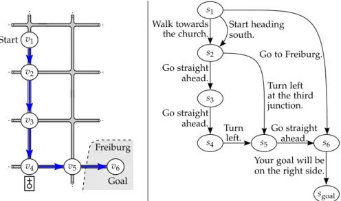
As illustrated in Figure2.1, we model the environment as a graph
G= (V,E), where the nodes v ∈ V represent intersections, and the edgese ∈ Erepresent streets. The space of all directions that guide a user through the environment from their current location v1 to
a specific destination location vgoal along a given route is encoded
by a deterministic MDP M. In particular, each action a of the MDP corresponds to a single instruction that guides the user from node vi
v1 v2 v3 v4 v5 v6 s1 s2 s3 s4 s5 s6 sgoal Go to Freiburg. Go straight ahead. Turn left at the third junction. Go straight ahead. Go straight ahead. Turn left.
Your goal will be on the right side. Start heading
south. Walk towards
the church.
Figure2.1: The problem of giving route directions as a reinforcement learn-ing problem. Left: The route to be described (blue). Right: The corresponding Markov decision process encodes all valid descrip-tions of the route.
to nodevj. Consequently, each trajectoryτin theMDP M corresponds to valid directions that guide the user all the way from its current location to its target location. For example, the descriptions “Walk towards the church. Go straight ahead. Go straight ahead. Turn left.” and “Start heading south. Turn left at the third junction” are both complete, valid, unambiguous descriptions for guiding a user from the start node v1 tov5, but they have a different level of granularity
and amount of information that the recipient has to memorize. Hence, every path through the MDP from the start node to the goal node represents a valid natural-language description of thesameroute, but indifferentwords.
We assume that all actions are deterministic, meaning that we expect that the recipient correctly executes the instructions. In practice, this might not be the case, as the user might miscount intersections, confuse left and right, or there might be changes in the environment such as a new street that had not yet been registered in the map that the algorithm used to generate the description. However, it would be difficult to incorporate user mistakes, as the person or algorithm giving the directions can hardly foresee what error the recipient will make. Without knowing the error, it is not possible to give meaningful instructions for correcting the error in advance. This problem could be alleviated by altering the route to reduce the risk for errors as Goeddel et al. [59] propose, or by including “When you arrive at . . . , you’ve gone too far” instructions, as Lovelace et al. [100] suggest. Both approaches, however, are computationally expensive and difficult to integrate into a common system.
TheMDPdefined here is acyclic, as returning to a previously visited state would be redundant. As there are no cycles and each action advances the user’s state towards the goal, theMDPhas a finite horizon, thus discounting factors are not necessary andγcan be set to1. These properties are desirable as they make the learning algorithm more efficient.
2.3.2 Maximum entropy inverse reinforcement learning
If the reward function of an MDP is known, reinforcement learning can be used to derive a policy that optimizes the expected cumulative reward. In our case, however, the reward function is inaccessible as we do not have an explicit representation of the goals that human route describers optimize for. Instead, we only have access to a body of demonstrations represented as a set of trajectories through theMDP and we assume that human subjects created these demonstrations by following an underlying unknown reward function. The goal of Inverse Reinforcement Learning (IRL) [119] is to determine a new reward function and a corresponding policy that can be transferred to new problems for creating trajectories with similar properties as the demonstrated trajectories.
The properties in which the newly created trajectories should be sim-ilar to the demonstrated are calledfeatures. A feature f :(S,A)T →R
maps a trajectoryτ={(s1,a1), . . . ,(sT,aT)}to a real value. Examples
for features are the length of the trajectory, frequencies of particu-lar states or actions, or frequencies of repeating elements along the trajectory. All features combined form a feature vector fτ ∈Rn of a trajectoryτ.
The reward function R decides on the distribution of the feature values when sampling new trajectories and we consider the distribu-tion of these feature values to choose the reward funcdistribu-tion that best matches the demonstrations. Hence, we define Ras a function of the feature values parameterized by a parameter vector θ ∈ Rn. From each possible reward function Rθ, a policyπθcan be derived using reinforcement learning. When this policyπθis applied to anMDP, it induces a probability distribution pθ(τ)over all trajectoriesτleading through theMDP’s graph. Given this probability distribution, the goal ofIRLis to find suitable parametersθof the reward function so that the following necessary condition is satisfied:
˜
fτ =Epθ[f(τ)]. (2.2)
˜
fτ is the empirical feature vector summed up over all demonstrations τ, andEpθ[f(τ)]is the expectation value of the feature vector over all demonstrations.
While this necessary condition guarantees that the learned policy reproduces the same feature value distribution when applied to the
training data, it does not lead to a unique solution. There is an infinite number of reward functions that produce the same feature distribu-tions, including solutions that overfit to the training data or introduce preferences for certain policies that are not part of the training demon-strations and do not reflect the hidden true reward function. Hence, we follow the principle of maximum entropy [80] that suggests se-lecting the distribution that least favors any particular outcome while still satisfying the necessary constraint from Equation2.2. Ziebart ap-plied this maximum entropy principle toIRL, leading to the Maximum Entropy Inverse Reinforcement Learning (MaxEnt IRL) approach [189].
TheMaxEnt IRLapproach optimizes the objective function
p?θ=argmax
pθ
Hpθ(τ) such that ˜fτ =Epθ[f(τ)], ( 2.3) whereH(pθ)is the Shannon entropy of distribution pθ.
Solving this optimization problem in the general case is hard, as it requires to determine a probability distribution over the large space of all possible trajectories in theMDP. To make this problem tractable, we adopt the same assumptions and simplifications that Ziebart proposed. First, we transfer the Markov property of the MDP also to features, requiring that all features must be the sum of values assigned to indi-vidual states or actions and that the value assigned with a state must not depend on previous or future states. Instead of having to estimate the probability of each complete trajectory, this assumption allows us to estimate the visitation frequencyDθ(s,a)of each state-action pair
(s,a)in theMDPand calculate the expected feature distribution as
Epθ[f(τ)] =
∑
(si,ai)∈τDθ(si,ai)f(si,ai). (2.4)
If we also assume that the reward function is a linear combination of the feature values
Rθ=
∑
(si,ai)∈τ
θTf(si,ai), (2.5)
then the solution of Equation2.3is given according to Ziebart [189] as
p?θ(τ) ∝ e−θ
Tf(τ)
. (2.6)
Our goal is now to maximize the likelihoodp?θ(τ)of the trajectories
demonstrated by the user. To solve this problem, we apply gradient-based optimization on the logarithmic likelihood to iteratively refine the parameters θ to achieve feature matching. The gradient with respect to the parameters θof the reward function is
∇θlnp?θ(τ) = ˜fτ−Epθ[f(τ)] (2.7)
The empirical feature count ˜fτcan be determined directly by summing up the features in the demonstrated trajectories.
To compute the expected feature countEpθ[f(τ)], we use Ziebart’s ef-ficient dynamic programming algorithm [189] to compute the expected visitation frequencyDθ(si,ai)of each state-action pair(si,ai)∈τ. Al-gorithm2.1 shows the original algorithm proposed by Ziebart. The algorithm has four stages: First, a backward pass propagates a proba-bility massZ from the goal nodes towards the start nodes. This can be interpreted as a “flooding” the graph with mass injected at the goal nodes and transporting the mass along the transition edges in opposite direction one node at a time. Hence, this backward step has to be repeated Ntimes for a finite time horizonN. The second phase computes the policy π ai,j |si
that specifies which action to take in each state. This policy is computed as the ratio of the probability massesZai,j of the outgoing actions and the massZsi of the state. In the
third phase, a forward pass propagates the state visitation frequencies
Dsi from the initial nodes towards the goal nodes according to the
computed policy and transition probabilities. Again, this step has to be repeated for a finite time horizon. In the fourth step then accumulates the visitation frequencies of the individual time steps to compute the overall state frequencies.
As explained above, our MDP graph is acyclic with a finite hori-zon. Hence, we can reduce the computation time for the visitation frequencies even further by processing the states in topological order. If the states are processed in topological order, only a single sweep is necessary to propagate the visitation frequencies along the graph, so the visitation frequencies converge faster. Mathematically speaking, we define a partially ordered set(S,≤)over the set of statesSso that
si ≤ sjif there is a path fromsitosj in the directed graph representing
theMDP. Propagating the probability masses in this order eliminates the need for repeating the propagation step as the probability masses will not change anymore after the first pass. Algorithm 2.2 shows our modified version of Ziebart’s algorithm. In Ziebart’s original for-mulation, rewards are attributed to states only, hence the algorithm computes state visitation frequencies only. As the policy is also ex-plicitly computed, however, computing the visitation frequencies of state-action pairs can be done straightforwardly, allowing us to at-tribute rewards to any combination of state, action, and successor state of a transition (but not to other states and actions before or after the transition due to the Markov property).
2.3.3 Features
Inverse reinforcement learning uses feature vectors to characterize each possible solution of the task to be learned and tries to imitate the style of the given demonstrations by matching the feature value distribution. Hence, the choice and definition of features is critical for the learning task. In our scenario, the features represent properties
Algorithm2.1Ziebart’s algorithm for computing state visitation frequencies from [189]
//Backward pass
1: Zs
terminal ←1
2: for Niterations compute recursively: 3: Za i,j ←
∑
k P sk |si,ai,j ereward(si|θ)Z sk 4: Zs i ←∑
ai,j Zai,j+1{si=sterminal}//Local action probability computation
5: π θ ai,j |si ← Zai,j Zsi //Forward pass 6: Ds i,t ←P0(si)
7: for Niterations recursively compute recursively: 8: Ds k,t+1 ←
∑
si∑
ai,j Dsk,tπθ ai,j |si P sk |ai,j,si //Summing frequencies 9: Ds i ←∑
t Dsi,tAlgorithm2.2Our modified algorithm for computing visitation frequencies of state-action pairs for acyclic finite-horizonMDPs
//Pre-process graph
1: Sort and re-index states so that si ≤ si+1 according to topologic
order of theMDPgraph //Backward pass 2: Zs terminal ←1 3: forifrom|S|to 1 do 4: Za i,j ←
∑
k P sk |si,ai,j eθTf(si,ai)Z sk 5: Zs i ←∑
ai,j Zai,j+1{si=sterminal}//Local action probability computation
6: πθ ai,j |si ← Zai,j Zsi //Forward pass 7: Ds i ← P0(si) 8: forifrom 1 to|S|do 9: Ds i ←Dsi+
∑
k∑
ak,i Dskπθ(ak,i |sk)P(si |ak,i,sk)//Calculate state-action pair frequency
10: D
θ(si,ai)← Dsiπθ ai,j,si
Feature Description
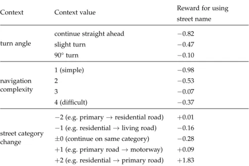
number of instructions total number of instructions in the route description number of slots number of pieces of information an instruction contains
(see Section2.3.3)
abstraction level turn-by-turn instruction, chunked instruction, or desti-nation description
segment length length of the described route segment in meters number of intersections number of intersections covered by the instruction street name references number of street names mentioned
street name saliency saliency of the street name if mentioned according to the web search metric described in Section2.4.1
cross street references number of crossing street names mentioned cross street saliency saliency of crossing street if mentioned
street category references number of street categories mentioned (footpath, resi-dential road, motorway, etc.)
cross street category ref. number of crossing street categories mentioned “head towards” ref.
number, saliency and distance of landmarks that in-dicate the heading, but are not part of the route, e.g. “head towards the ocean”
“head towards” saliency “head towards” distance
landmark reference number of landmarks mentioned landmark distance distance of landmark if mentioned
landmark direction direction of landmark relative to recipient (back, side, ahead, etc.)
landmark saliency saliency of landmark based on the number of hits re-turned from a web search for the landmark’s name (see Section2.4.1for details)
turn anchor turn at landmark / after metric distance / etc.
metric reference discretized mileage mentioned, e.g. “turn right after 200 m”
counter reference counter value mentioned, e.g. “turn right at the second intersection”
reference frame at turns cardinal (e.g. “turn north”), allocentric (e.g. “turn left”), or using counter (e.g. “take the second exit in the round-about”)
reference frame at start cardinal, relative to landmark, or using street name (e.g. “Start on Main St.”)
“n times” chunking e.g. “turn right twice”
Table2.1: Features characterizing route descriptions. See Section2.3.3for detailed explanations.