Abstract—An early warning system is a set of procedures designed to protect human lives and minimize damages to be expected from a flood/draught which exceeds a certain critical level. The Flood and Draught Automated Local Evaluation in Real Time System for Mahasarakham Province (FD-ALERT) brings significant convenience to personnel engaged in flood/draught forecasting and control and allows real-time contribution of a wide range of experts at other spatial locations in times of emergency. The conceptual framework and detailed components of the proposed model are illustrated. The system offers great flexibility, portability, reusability and reliability. The prototype FD-ALERT has been developed in Mahasarakham with a satisfactory result.
Keywords—Real-time hydrological model, Web-based GIS, Flood/Draught Monitoring, Forecasting.
I. INTRODUCTION
HE effective and efficient operation of water resources relies on accurate and prompt forecast of water resources inflows. Traditional reservoir forecasting in Thailand is normally based on manual calculations by experienced hydrologists or through standalone computer programs [1]. Owing to the complexity of hydrological process, manual calculation is not only difficult to apply, in particular to novice engineers, but also a very time-consuming task even for specialist hydrologists [9]. The emergence of computer programs on flood/draught forecasting system greatly improved the forecasting level and has been applied well throughout the past decade. In general, these systems have realized many advantages in terms of productivity such as easiness of operating, great speed of processing, and reduced possibility of error due to the subjective judgment involved [6,7].
However, with the recent advent of integrated water resources management system, shortfalls about these systems emerge: local information cannot be shared directly by other geographically dispersed departments or individuals who need it; departments in different roles cannot collaborate in flood /draught forecasting due to the lack of communication infrastructure within the system; productivity is hampered by the lack of effective channels for prompt information access and collaboration among project personnel [3], etc.
A Web-based, distributed computing environment is highly desirable in modern flood/draught prediction and control. The recent advances in Internet technology and distributed computing paved the way for developing Web-based distributed systems which is a trend of modern software systems.
Web-based technology, which is a powerful tool for communication in itself, provides a convenient and cost effective manner for gathering, filtering, managing, and sharing information [5]. There are many Web-based applications developed for various design and decision making problems, such as architectural design and performance evaluation [2,4], collaborative research and development [8], and mechanical design and manufacture [10, 11]. The Web-based environment is emerging as a very important development and delivery platform for real-time flood forecasting system.
In this paper, a framework of the Flood and Draught Automated Local Evaluation in Real Time System for Mahasarakham Province (FD-ALERT) is presented and implemented. The (FD-ALERT) brings significant convenience to personnel engaged in flood and draught forecasting and control and allows real time contribution of a wide range of experts at other spatial locations in times of emergency so long as Internet is accessible, and therefore provides opportunities for improving the transfer of information and knowledge from the hydrological scientists and managers to decision makers. Using Web browsers can also eliminate the need to install and maintain specialized ‘client’ software on each machine. Hence the overall cost of system implementation, distribution and administration is significantly reduced [10].
The objective of the present study is to develop an FD-ALERT by modeling the flood and draught forecasting and database. The paper is organized as follows. A purposed system of the Web-based and implementation of the FD-ALERT is presented in Section 2. A case study example is presented in Section 3 that illustrates in detail the application of the FD-ALERT. Finally, conclusions are drawn in Section 4.
II. DEVELOPMENT OF FD-ALERT SYSTEM
An effective real-time flood and draught modeling and prediction system could help mitigate the worst effects of flood
Flood and Draught Automated Local Evaluation
in Real Time System for Mahasarakham
Province
W. Kanarkard, W. Taweepworadej, R.G. Adams, and N. Davey
and draught disasters through the rapid dissemination of information regarding threatened areas that is simple maps of potential flood water and draught distribution.
Real Time Rainfall data collection Flood Analysis Draught Analysis River Quality Monitoring Data
Internet GIS Alert system General Users
Authorised Users Expert in Hydrology System Administrator
[image:2.595.57.263.133.270.2]FD-ALERT
Fig. 1 Conceptual Framework
The conceptual framework of FD-ALERT is shown in Fig. 1, using the architecture presented as above. General users, authorized users, experts in hydrology, system administrator, can synchronously access the Web-based interfaces independently, for inputting data, forecasting, operating, analyzing, making decision, querying, etc. The main database constitutes five main modules, real-time rainfall data collection, flood analysis, draught analysis, river quality monitoring data and the Internet GIS Alert system. Users can easily interact with the contents of the database. These results being spatial or non-spatial data are processed in a Web server and then displayed immediately in the client machine from any computer in the world. This fast communication via the Internet is probably the fastest and the most economic media.
The system was designed to act as a means of archiving and for updating hydrological data as well as for using data in a rapid decision support system. The system has been developed with the recognition that several user requirements are currently implemented within watershed simulation models. Therefore, the aims of the project are:
1. Real-time data access and analysis. One of the aims is to provide data accessibility and analysis by permitting access to real-time data through the Web.
2. On-line flood and draught analysis. A detailed implementation of hydrological analysis should be undertaken in order to provide a decision support system.
3. Development of a user-friendly interface. A well-designed interface should be implemented to facilitate the use of the system so that users can focus on the data, not the interface.
4. Platform-independence. An additional aim is to provide data accessibility and analysis regardless of the computing platform so that whoever has access to the Internet can run the programs.
5. Inter-departmental collaboration. A system should be published on a project Web site, which allows users and stakeholders to share data, as well as software as means for coordinating activities between users from different geographic locations.
6. Cost-effectiveness. One of the aims is to use cost-effective
software development and inexpensive equipments. III. APPLICATION EXAMPLE
The Internet and the Web are exceptionally important tools, which can potentially contribute to the achievement of the goals of water resource management. The benefits and the advantages that the Internet and the Web offer to water resource management are openness, a user-friendly interface, interactivity, flexibility, and fast communication. It is relatively cheap and therefore gives the general public access to a variety of both GIS systems and data of varying degrees of sophistication. This direct access, as a means of allowing wider involvement and participation in environmental decision-making, is an important prerequisite of water resource management. This accessibility occurred because of user interface familiarity, portability across many computer platforms and capability to display different multimedia and hypermedia formats.
Therefore, by integrating a Web-based system with wireless monitoring network, real-time data can be obtained and disseminated instantly. These important features and tools that enhance and improve water resource management are available and therefore it becomes a question of using them efficiently and professionally.
The proposed system was conceived through a general need for real-time data acquisition, data management, a user-friendly-interface, and accessibility of the data and applications. An effective real-time flood and draught modeling and prediction system could help mitigate the worst effects of flood and draught.
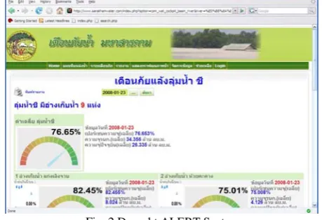
The Chee and Moon river are used for flood control. Bank level of river, water level, rainfall amount, are three important characteristics to evaluate a specific flood. The reservoir is used for draught control, as well as for irrigation purposes. Level of capacity, effective storage capacity and rainfall amount are three important characteristics to evaluate a draught and they provide foundation for the operation of reservoirs. An example draught/flood forecast from a flood/draught forecasting system is shown in Fig. 2 and 3.
[image:2.595.311.541.569.726.2]Fig. 3 Flood ALERT System
[image:3.595.312.543.287.629.2]These characteristic values are calculated within flood/draught analysis module and stored in the database for the subsequent process. The flood/draught frequency is also calculated by comparing the characteristics with the designed flood/draught. It uses observed data to develop a conceptual model that fits the observed input (area rainfall or upstream discharges or water levels) and output (water discharge or level at some downstream gage) relationship illustrated in Fig. 4.
Fig. 4 Parameter input interface
Fig. 5 Reservoir Information
The data input procedures in this project use rain gauges to measure rainfall. The objectives of the data analysis program
are to allow the user to set queries and to retrieve useful information to satisfy the specific requirements of decision-makers, and an important function of the analysis is the ability to predict what will occur at a location, at another point in time, and under certain conditions.
Depending on user-selected date, the graph applet viewer shows changes in rainfall, temperature, and other variables as they occur depicted in Fig. 5.
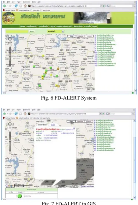
Currently, the analytical capabilities of GISs related to the structure of the database (raster or vector) are used, and the proposed prototype uses the raster GIS structure because that raster family is determined to have greater analytical power. Fig. 6 and 7 illustrate the alert map of draught area with different colors. The resulting data indicates the highest (yellow)/lowest (green)/average (brown) level of draught within a period of time.
Fig. 6 FD-ALERT System
Fig. 7 FD-ALERT in GIS
[image:3.595.53.282.376.729.2]rain gauge networks, extensive research efforts are still required to develop systems that incorporate real-time data with a GIS application so that real-time data can be obtained with sufficient timeliness and rapid now casts can be produced.
Fig. 8 River quality monitoring
Fig. 8 illustrates different parameters of river quality of River Chee and Moon at different stations within a period of time. Finally, data analysis is not only useful for professionals and decision makers but also for a public that demands openness, as is reflected in legislation such as the Mahasarakham Provincial Governor's Office and the Mahasarakham Provincial Irrigation Office, which specify that all information must be available to anyone who wants it. Data accessibility and participation are one of the issues that need to be considered in the development of a successful flood and draught forecasting system. Therefore more consideration needs to be undertaken in order to provide a better simulation and warning system not only for flood and draught forecasting but various environmental management systems.
IV. CONCLUSION
This paper discusses the development of a real-time Web-based data access system for flood and draught forecasting using cost-effective tools. A Web-based interface surpasses the limitation of a traditional decision support system that stores data, model, and user interface on a single computer. It is a convenient system and can be applied to a wide variety of vital applications necessary for the public good.
One of the advantages of the Web is that it generates information presentation on demand. With the inclusion of cockpit for spatial data navigation and temporal data visualisation, a system can achieve flexible user interaction without sacrificing efficiency. Another significant advantage of the Web is that access to it is relatively inexpensive and stakeholders can form collaborative contacts. A range of innovative technologies are being developed that offer different ways of modeling over the Internet.
Our project exploits recent networking technology to permit Internet users to obtain delivery of the desired flood and draught prediction and management data in real-time and
provides the tools to analyse these data. Using the Web to develop data access and projected analysis for real-time watershed analysis offers tremendous potential.
Not only to the benefit of environmental users, but also for other disciplines who need to locate and analyse data. We believe that a Web-to-hydrological model interface can play a beneficial role in real-time watershed modeling, as a valuable research and educational medium and as a link bringing stakeholders together for collective decisions.
This research presented a Web-based distributed system for real-time flood and draught forecasting which has been applied in Mahasarakham with a satisfactory result. This system has four significant features—wide accessibility, flexibility, reusability, and user friendliness. Simple and inexpensive Web browsers can expand the use of forecasting system to many people in the domain without additional networking facilities.
This permits the local authorities to take advantages of the knowledge and experience of hydrology experts, even if those experts are not in the vicinity. They can visit the Website and make decisions through Web browsers. Therefore, FD-ALERT provides opportunities for streamlining the transfer of information and knowledge from the hydrological scientists and managers to decision makers and thus enhancing forecast accuracy and reliability.
Furthermore, The FD-ALERT presented in this paper renders flood/draught forecasting process easier and more convenient through Web browsers.
ACKNOWLEDGMENT
This research was supported by the Mahasarakham Provincial Governor's Office.
REFERENCES
[1] C. Apirumanekul, Flood forecasting in the Mekong River Basin: an improvement plan for the flood forecasting system. International Conference on Mekong Research for the people of the Mekong, 18-21 October, 2006, Chiang Rei, Thailand.
[2] M. Goedicke, T. Meyer, Web-based tool support for dynamic management of distribution and parallelism in integrating architectural design and performance evaluation. Proceedings of the international workshop on software engineering for parallel and distributed systems, IEEE, New York, 1999 p. 156–63.
[3] D. Liu, J.X. Cheng, K.H. Law, G. Wiederhold, R.D. Sriram. Engineering information service infrastructure for ubiquitous computing. J Computing Civil Eng, ASCE, 2003;17(4):219–29.
[4] K.R. Molenaar, Songer A.D. Web-based decision support systems: case study in project delivery. J Computing Civil Eng, ASCE, 2001;15(4): 259–67.
[5] S.T. Ng, E. Palaneeswaran, M.M. Kumaraswamy, Web-based centralized multiclient cooperative contractor registration system. J Computing Civil Eng, ASCE, 2003;17(1):28–37.
[7] E.J. Plate, A forecasting system for the lower Mekong. In: Mekong Research for the People of the Me- kong, Chiang Rei, Thailand, 18-21 October 2006.
[8] O. Tamine, R. Dillmann, KaViDo—a Web-based system for collaborative research and development processes. Computing Ind, ,2003;52(1):29–45.
[9] H. Tanaka, Flood forecasting of the Mekong River in 1997. In: FAO/ RAP Publication 1999/14. FAO, Bangkok, pp. 109-117.
[10] X.W. Xu, T. Liu , A Web-enabled PDM system in a collaborative design environment. Robotics Comput-Integr Manufact, 2003;19(4): 315–28.