441
Abstract— Nowadays there are formidable challenges facing decision makers in order to rangeland management. Allocation of limited rangelands among the various stakeholders, lack of sufficient environmental policies for sustainable use of rangelands as well as degradation of these areas have caused increasing concern among managers and revealed the importance of Land suitability analysis. As regards a broad range of criteria is required for performing effective land suitability selecting of appropriate method to handle such wide heterogeneous criteria. Spatial Analytical Hierarchy Process method as a commonly use method of compensatory model is a suitable tool for this purpose. The main aim of this paper is to examine a relatively new method of multi criteria evaluation by using spatial analytical hierarchy method for determining the most suitable areas for rangelands in Taleghan basin. Results indicate that the spatial analytical hierarchy process is a powerful support system resolving different uses of land suitability issues in the region.
Index Terms—Spatial analytical hierarchy process; land suitability evaluation; rangeland use; Taleghan Basin; Multiple criteria evaluation.
I. INTRODUCTION
Land Suitability Analysis (LSA) is a GIS-based process applied to determine the suitability of a specific area for considered use, i. e. it reveals the suitability of an area regarding its intrinsic characteristics (suitable or unsuitable). Also this analysis involved with considering wide rages of criteria including environmental, social and economic factors. Appropriate handling of such broad and heterogeneous maps requires applying a flexible tool. The Spatial Analytical Hierarchy method was introduced by Saaty in the mid 1970s and developed in 1980s 1-5 is among the best method which is
suitable for carrying out these kinds of analysis. The combination of Spatial AHP method as one of the commonly used methods of spatial multi criteria analysis (SMCA) with GIS is a new trend in land suitability analysis. As regards the spatial multi criteria analysis inclusion of an explicit geographic component it is considered different from conventional multi criteria techniques 6. In general one of the
most important uses of GIS is the land use suitability mapping and analysis 7-8. As environmental and resource
planning and management point of view the Analytic Hierarchy Process is among the fastest growing decision-analytic techniques 9.
1Faculty of Biological Sciences, Shahid Beheshti University, Tehran, Iran
2*Department of Environment and Energy, Islamic Azad University,
Science and Research Branch, Tehran, Iran; Corresponding author: [email protected], Tel/Fax: 098-2166601826
There have been a lot of researches carried out by scientist around the world. In 2000, Nisar Ahamed et al. 10 conducted
Crop-land suitability analysis using GIS-based fuzzy membership model. Results presented that maximum area is potentially suitable for ground nut growing. Sicat et al. 11,
modeled farmers' knowledge for land suitability classification. Malczewski 12 conducted a research to
incorporate the concept of fuzzy (linguistic) quantifiers into the GIS-based land suitability analysis. Shearer and Xiang 12
conducted a land suitability assessment for a park land-banking program in North Carolina. They incorporated the synchronized voices into an assessment model to estimate which level of suitability best characterizes each parcel of land for a particular use. Marull et al. 14 indicated a Land
Suitability Index for Strategic Environmental Assessment in metropolitan areas. They examined the presented model in Barcelona Metropolitan Region (BMR) and finally proposed to the other metropolitans.
This study aims to present how powerful the S-AHP method is in handling the land suitability analysis. For this propose the Taleghan Watershed was selected as study area. Taleghan is a mountainous region with sharp slopes located in 120 kilometers northwest of Tehran (capital of Iran) between latitudes 36°05′17.45″–36°20′45.93″ N and longitudes 50°39′33.39″–51° 11′26.5″ E. a wide area of the region is covered by rangelands and animal husbandry is the main job of villagers.
II. MATERIAL AND METHODS
A. Selecting of criteria
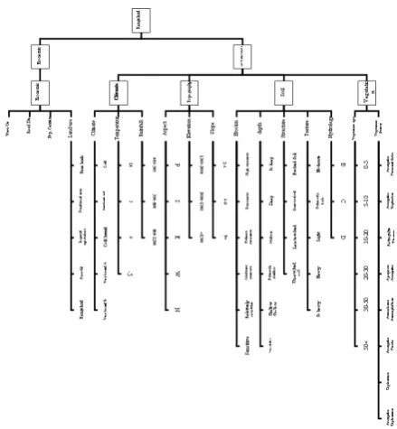
In this study criteria were selected using the literature reviews of internal and external references, interviewing with experts (questionnaires) and availability of data (Fig. 1).
Land Suitability Analysis using Multi Attribute
Decision Making Approach
442
Fig. 1: the analytical structure of criteria
B. Weighing of criteria
For determining the relative importance of criteria the pair-wise comparison matrix using Saaty's nine-point weighing scale were applied.
TABLE1:NINE-POINT WEIGHING SCALE FOR PAIR-WISE COMPARISON
(SAATY,1980)
Descriptions Scale Equally preferred 1
Equally to moderately 2 Moderately preferred 3 Moderately to strongly 4 Strongly preferred 5 Strongly to very Strongly 6 Very Strongly preferred 7 Very Strongly to extremely 8 Extremely preferred 9
It should be noted that for preventing bias thought criteria weighting the Consistency Ratio was used 15-18.
1
.
.
max−
−
=
n
n
I
C
λ
.
.
.
.
.
.
I
R
I
C
R
C
=
Where;
n= the number of items being compared in the matrix
max
λ
= the largest Eigen value RI = random consistency index C.OverlyingAfter weighing of criteria regarding their importance for land suitability analysis, all criteria maps were overlaid using suitability index.
1
1
1
. 1*
. *
.
. 2*
*
...
*
*
m
i L
y j
z
SI
RI A
RI Bi RI KBi
RI A
RICy RIKCy
RIAN
RIDz RIKDz
= = =
=
+
+
∑
∑
∑
Where, SI is the suitability index of each cells; N is the number of main criteria; RIA1, RIA2 …RIAN are the relative importance of the main criteria A1, A2 …AN, respectively; m, i and j are the number of sub criteria directly connected to the main criteria A1, A2 …AN, respectively; RIB, RIC and RID are the relative importance of sub criteria B, C and D directly connected to the main criteria A1, A2 …AN, respectively; RIKB, RIKC and RIKD are the relative importance of indicators category k of sub criteria B, C and D and main criteria A1, A2 …AN, respectively 15-20.
III. RESULT AND DISCUSSION
A. Land suitability analysis for rangeland use
Effective parameters in land suitability for given land use are as follows which their importance is mentioned briefly:
Land cover: One of the most important factors affecting the land suitability classification for rangeland is vegetation type and density. Whatever land is rich and diverse regarding palatable species for livestock will definitely have more suitability for rangeland use.
Climate: Rainfall is among factors affecting the growth of rangeland plants.
Minimal rainfall for rangeland plant growth is not so inadequate. Usually annual rainfall of 400 mm is considered suitable.
Soil: Usually are allocated deep and heavy soils to agriculture and soils with medium to coarse gravel or rubble stone and semi-evolved with moderate deep to shallow for rangeland.
Topography: Slope is very important factor for land suitability analysis of rangeland. Places with high slope (more than 30 percent), is not suitable for livestock grazing due to being impassable. On the other hand the very sharp slopes as result of low soil depth and lack of evolved soils have not appropriate condition for growth and diversity of palatable rangeland plants. Meanwhile the elevation criteria because of effect on climate and vegetation are considered as important factor in land suitability analysis for rangeland.
Land uses: The rangeland is in conflict with industrial development but in compatible with forestry (in condition of compliance of management and control principles).
Distance from the villages, streams and springs: Considering of villagers' main job (animal husbandry), places are suitable for rangeland where in addition of having biophysical factors are not far away from villages due to easier transportation of livestock from villages to the rangelands. On the other hand the availability of surface water sources such as springs, rivers and streams in order to supplying the water needs of plants and livestock is essential. Eq. 1
443 B. Standardization of criteria
In order to compare criteria with each other, all values need to be transformed to the same unit of measurement scale (from 0 to 1), whereas the various input maps have different measurement units (e.g. distance maps, temperature etc.) 21.
In this research two standardization methods were applied as follows:
Cost- benefit analysis: for standardization of all distance criteria this method was used. For example in population centre criterion the Cost- benefit analysis assigns the highest score (suitability degree=1) to the nearest area to the population centers and the lowest one (suitability degree=0)
allocates to the furthest. In this way all criteria map were converted to the same scale (0-1).
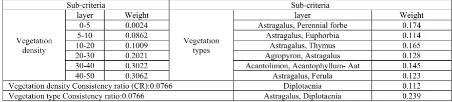
Spatial AHP: all applied criteria were standardized using AHP method but distance criteria. Pair-wise comparison matrix for standardization of vegetation is present in Table 2. Table 2: weights obtained from standardization of vegetation criteria.
TABLE2: WEIGHTS OBTAINED FROM STANDARDIZATION OF VEGETATION CRITERI
Sub-criteria Sub-criteria Vegetation
density
layer Weight
Vegetation types
layer Weight 0-5 0.0024 Astragalus, Perennial forbe 0.174
5-10 0.0862 Astragalus, Euphorbia 0.114 10-20 0.1009 Astragalus, Thymus 0.165 20-30 0.2021 Agropyron, Astragalus 0.128 30-40 0.3022 Acantolimon, Acantophyllum- Aat 0.145 40-50 0.3062 Astragalus, Ferula 0.123 Vegetation density Consistency ratio (CR):0.0766 Diplotaenia 0.112
Vegetation type Consistency ratio:0.0766 Astragalus, Diplotaenia 0.239
C.Weighing of criteria
After standardization all criteria and sub criteria were weighted using pair wise comparison method. An example of
main criteria weighing is given in Table 3.
TABLE3: WEIGHING MATRIX FOR MAIN CRITERIA
Criteria Weight Criteria Weight
Environmental factor= 0.892
Soil=0.1905
CR=0.0722
Erosion 0.312 Soil hydrology 0.202 Soil depth 0.165 Soil structure 0.165 Soil texture 0.155
Land cover= 0.5096 Vegetation density Vegetation type 0.7098 0.2902 Climate= 0.1231 Temperature Rainfall 0.597 0.403 Topography= 0.1237 Slope 0.589
Elevation 0.403
Economic factors= 0.125 Land use and availability factors=0.0531
CR=0.727
Land use 0.4032 Distance from population
centers 0.2984 Distance from surface water 0.2984
D.Preparing of land suitability maps
444
Fig.2: suitability maps of a) soil, b) topography, c) climate, d) vegetation, e) socio economic and f) final suitability map of Taleghan Basin for rangeland
V. CONCLUSION
As Figs. 4 and Table 3 present, only a small fraction of the total area has a high suitability for rangeland. The reason for this can be investigated in wide area of shallow, undifferentiated and non-fertile soils as well as poor management of livestock in study area . So the rangelands of the region have poor richness despite being so large in area . The significant point is that there is neither 0 nor 1 suitability degree among the range of regions suitability degrees. This is caused due to application of multi attribute decision making approach from compensatory models.
TABLE4: THE AREA OF SUITABILITY DEGREES
No. Suitability degree Area (ha) No. Suitability degree Area (ha) No. Suitability degree Area (ha)
1 0.06 15000 27 0.32 42332500 53 0.58 260000 2 0.07 120000 28 0.33 60985000 54 0.59 1195000
3 0.08 177500 29 0.34 50930000 55 0.60 1092500
4 0.09 765000 30 0.35 46602500 56 0.61 830000 5 0.10 1310000 31 0.36 26345000 57 0.62 865000 6 0.11 1250000 32 0.37 25680000 58 0.63 925000 7 0.12 1605000 33 0.38 20322500 59 0.64 1850000
8 0.13 1262500 34 0.39 16347500 60 0.65 1327500
9 0.14 6050000 35 0.40 15362500 61 0.66 500000 10 0.15 5820000 36 0.41 27990000 62 0.67 780000 11 0.16 7565000 37 0.42 20927500 63 0.68 457500 12 0.17 8075000 38 0.43 10145000 64 0.69 807500 13 0.18 6240000 39 0.44 12772500 65 0.70 1142500
14 0.19 7750000 40 0.45 6477500 66 0.71 1532500 15 0.20 8075000 41 0.46 8280000 67 0.72 2352500 16 0.21 15865000 42 0.47 6740000 68 0.73 1075000
17 0.22 14255000 43 0.48 4575000 69 0.74 250000 18 0.23 187675000 44 0.49 21845000 70 0.75 297500 19 0.24 30492500 45 0.50 3470000 71 0.76 210000 20 0.25 37115000 46 0.51 2607500 72 0.77 260000 21 0.26 37252500 47 0.52 3392500 73 0.78 97500 22 0.27 32800000 48 0.53 2875000 74 0.79 102500 23 0.28 23620000 49 0.54 34875000 75 0.80 27500 24 0.29 16802500 50 0.55 1712500 76 0.81 5000 25 0.30 15840000 51 0.56 895000 77 0.82 2500 26 0.31 14872500 52 0.57 722500 78 0.83 15000
In this model, never the best or worst cases exist, and only satisfying result can be achieved. Due to the complexity of ecosystems, existence of all factors desirable for a particular purpose seems unlikely. So there is no perfectly suitable area in the nature. In order to better display of results, the final suitability rangeland map was classified according to suitability degrees . Thus the suitability degrees of 0-0.5 as poor, 0.5-0.75 as medium and 0.75-1 as high suitable rangeland areas were defined (Fig.4) .
445 In general, the results obtained from this study indicate that:
- The analytical hierarchy process is a powerful tool for decision making in land suitability issues regarding environmental and economic factors. By using this method whole area can be classified in detail about the suitability degrees for considered land use. Specified land suitability helps decision makers for defining effective management plan for each part considering its suitability index .
- High suitability areas contain only a small proportion (101.7500 ha) of whole (80000 ha) so the implementation of appropriate management plans in this watershed is essential . -A wide ranges of area (56228 ha) applied as rangeland has poor suitability. This will lead to a widespread degradation through the region in near future .
-The region of 3670.2500 ha has medium suitability. It reveals that these areas are endangered to be poor suitable unless supervised properly.
In general to regenerate damaged pastures and to prevent further deteriorations, measures should be thought regarding rangeland and livestock management as the followings:
Conversion of mobile Animal Husbandries to the static ones, rangeland land covers reclamation, especially palatable rangeland species ,grazing considering the ranges potential, trying to conversion livestock combination from goats and sheep to cattle because of less damage to the rangeland genetic improvement in livestock in order to husbandry livestock with high productivity efficiency. On the other hand, by cultivating forage for feed, pressure of uncontrolled grazing on rangelands will be highly prevented.
REFERENCES
[1] Saaty, T. L. 1980. The analytic hierarchy process. McGraw-Hill, New York.
[2] Saaty, T. L. 1988. Multi criteria Decision Making: The Analytical Hierarchy Process. RWS Publications, Pittsburgh, PA.
[3] Saaty, T. L. 1990. An exposition on the AHP in reply to the paper ‘remarks on the analytic hierarchy process.’ Manag. Sci., 36, 259–268. [4] Saaty, T. L. 1994. Highlights and critical points in the theory and
application of the analytic hierarchy process. Eur. J. Oper. Res., 74, 426–447.
[5] Saaty, T. L. 1995. Decision Making for Leaders: The Analytic Hierarchy Process for Decisions in a Complex World. 3d ed. RWS Publications, Pittsburgh, PA.
[6] Girard L. F., Cerreta M., De Toro P., Integrated Spatial Assessment:a Multidimensional Approach for Sustainable Planning. MTISD 2008 – Methods, Models and Information Technologies for Decision Support Systems, Università del Salento, Lecce, 1820.
[7] Malczewsk, J. (2004). GIS-based land-use suitability analysis: a critical overview. Progress in Planning 62 (2004) 3–65.
[8] Abu Bakar, Sh. (2007) Land Suitability for Rice Growing In the Klang Valley Using Geographical Information System and Analytical Hierarchy Process for Urban Food Security. Masters thesis, Universiti Putra Malaysia.
[9] Bello-Dambatta, A.; Farmani, R.; Javadi, A.A.; Evans, B.M., 2009. The Analytical Hierarchy Process for contaminated land management. Advanced Engineering Informatics, 23(4): 433-441.
[10] Nisar Ahamed, T. R., Gopal Rao, K., Murthy, J. S. R., 2000. GIS-based fuzzy membership model for crop-land suitability analysis. Agricultural Systems, 63(2): 75-95.
[11] Scat, R. S., Carranza, E. J. M., Nidumolu, U. B., 2005. Fuzzy modeling of farmers' knowledge for land suitability classification. Agricultural Systems, 83(1), 49-75.
[12] Malczewski, J. (2006). Ordered weighted averaging with fuzzy quantifiers: GIS-based multicriteria evaluation for land-use suitability
analysis. International Journal of Applied Earth Observation and Geoinformation, 8(4): 270-277.
[13] Shearer, K. S.; Xiang, W. N., (2009). Representing multiple voices in landscape planning: A land suitability assessment study for a park land-banking program in Concord, North Carolina, USA. Landscape and Urban Planning, 93(2): 111-122.
[14] Marull, J.; Pino, J.; Mallarach, J. M.; Cordobilla, M. J., (2007). A Land Suitability Index for Strategic Environmental Assessment in metropolitan areas. Landscape and Urban Planning, 81(3): 200-212. [15] Kheirkhah Zarkesh, M. M.; Ghoddusi, J.; Zaredar, N.; Soltani, M. J.;
Jafari, S.; Ghadirpour, A., (2010). Application of spatial analytical hierarchy process model in land use planning. Journal of Food, Agriculture & Environment Vol.8 (2): 970-975. 2010.
[16] Akash, B. A.; Mamlook, R.; Mohsen, M. S. (1999). Multi-criteria selection of electric power plants using analytical hierarchy process. Electric Power Systems Research, 52(1): 29-35
[17] Ong, S. K.; Koh, T. H.; Nee, A. Y. C., (2001). Assessing the environmental impact of materials processing techniques using an analytical hierarchy process method. Journal of Materials Processing Technology, 113(1-3): 424-431.
[18] Komac, M. (2006). A landslide susceptibility model using the Analytical Hierarchy Process method and multivariate statistics in perialpine Slovenia. Geomorphology, 74(1-4): 17-28.
[19] Siddiqui, M. Z., Everett, J. W. and Vieux, B. E. 1996. Landfill siting using Geographic information systems: A demonstration. J. Environ. Eng., June: 515-523.
[20] Kheirkhah Zarkesh, M. 2005. Decision support system for floodwater spreading site selection in Iran. Ph.D. Thesis, ITC, International Institute for Geo-information Science and Earth observation, Enschede, The Netherlands.