© 2014, IJCSMC All Rights Reserved 529 Available Online at www.ijcsmc.com
International Journal of Computer Science and Mobile Computing
A Monthly Journal of Computer Science and Information Technology
ISSN 2320–088X
IJCSMC, Vol. 3, Issue. 12, December 2014, pg.529 – 537
RESEARCH ARTICLE
STUDY OF LOCALIZATION SCHEME
WITH SINGLE MOBILE ANCHOR NODE
Mr. Atul D.Atalkar
1, Prof. Prashant S.Wankhade
21(M.E Student EXTC, ARMIET College Of Engineering, Sapgaon, Mumbai , INDIA)
2
(Assistant Prof. Department Of Electronics, Datta Meghe College of Engineering, Airoli, Navi Mumbai, INDIA)
Abstract: Various localization methods based on mobile anchor nodes have been proposed for assisting the sensor nodes to determine their locations. However, none of these methods attempt to optimize the trajectory of the mobile anchor node. Accordingly, this paper presents a path planning scheme, which ensures that the trajectory of the mobile anchor node minimizes the localization error and guarantees that all of the sensor nodes can determine their locations. The obstacle-resistant trajectory is also proposed to handle the obstacles in the sensing field. Later this path planning algorithm is adjusted so that it suits most of the effective localization algorithms. The performance of the proposed scheme is to be evaluated through a series of simulations with the ns-2 network simulator.
Keywords: PPL, WSN, Beacon, NAM, TCL, mobile anchor, Localization
INTRODUCTION:
Algorithm Description
In this section, we describe the Path Planning Based Localization (PPL) [1] with regard to single mobile anchor in WSN environment. This algorithm is typically a range based distributed algorithm.
© 2014, IJCSMC All Rights Reserved 530
field. In the localization scheme, a single mobile anchor node moves randomly through the sensing field broadcasting periodic three beacon messages containing its current coordinates. The locations of the individual sensor nodes are determined by exploiting the fact that the perpendicular bisector of a chord of a mobile anchor passes through the center of the circle twice. The obstacle resistant trajectory is solved through virtual beacon point generation.
Node Configuration Setting
The sensor nodes are designed and configured dynamically, designed to employ across the network, the nodes are set according to the X, Y, Z dimension, which the nodes have the direct transmission range to all other nodes.
Localization algorithm
In the localization scheme, a single mobile anchor node moves randomly through the sensing field broadcasting periodic beacon messages containing its current coordinates. it is assumed that the communication range over which a sensor node can detect broadcasts from the mobile anchor node is bounded by a circle and the sensor node is located at the center of this circle. As the anchor node moves through the sensing field, it broadcasts its coordinates periodically, and each sensor node chooses appropriate locations of the anchor node (called beacon points) to form chords of its communication range.
Mobile Anchor Path Planning Scheme
If three beacon points are obtained on the communication circle of a sensor node, it follows that the mobile anchor node must pass through the circle on at least two occasions. The distance between two successive vertical segments of the anchor trajectory (i.e. the resolution of the anchor trajectory) is specified as R−X, where R is the communication radius of the mobile anchor node and X is set in the range As a result, the mobile anchor node will pass through the circle more than three times
Obstacles-Resistant Trajectory
In a realistic environment, obstacles may appear in the sensing field and thus obstruct the radio connectivity between the anchor node and the sensor nodes during this occasion the sensor node identifies its location through virtual beacon points.
TCL Script. (path.tcl)
TCL Script (path.tcl) which we are using defines all nodes and all required parameters.
set val(chan) Channel/WirelessChannel ;# channel type
© 2014, IJCSMC All Rights Reserved 531
set val(netif) Phy/WirelessPhy ;# network interface type
set val(mac) Mac/802_11 ;# MAC type
set val(ifq) Queue/DropTail/PriQueue ;# interface queue type
set val(ll) LL ;# link layer type
set val(ant) Antenna/OmniAntenna ;# antenna model
set val(ifqlen) 512 ;# max packet in ifq
set val(nn) 67 ;# number of mobile nodes
set val(rp) AODV ;# routing protocol
set val(x) 4300 ;# X dimension of topography
set val(y) 2500 ;# Y dimension of topography
set val(stop) 20.0 ;# time of simulation end
set ns [new Simulator]
set topo [new Topology]
$topo load_flatgrid $val(x) $val(y)
create-god $val(nn)
#Open the NS trace file
set tracefile [open path.tr w]
$ns trace-all $tracefile
$ns use-newtrace
set namfile [open path.nam w]
$ns namtrace-all $namfile
© 2014, IJCSMC All Rights Reserved 532
set chan [new $val(chan)] ;#Create wireless channel
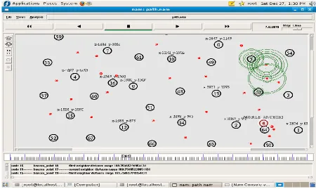
NAM file Network Animator File
(path.nam)
When a simulation is finished, NS produces one or more text-based output files that contain detailed
simulation data, i.e path.nam if specified to do so in the input Tcl (or more specifically, OTcl) script.
The data can be used for simulation analysis (two simulation result analysis examples are presented in
later sections) or as an input to a graphical simulation display tool called Network Animator (NAM).
NAM has a nice graphical user interface similar to that of a CD player (play, fast forward, rewind,
pause and so on), and also has a display speed controller. Furthermore, it can graphically present
information such as throughput and number of packet drops at each link, although the graphical
information cannot be used for accurate simulation analysis.
Location Details (location anchor1)
Another text based file is generated after end of simulation which gives the desired location of all
nodes. Like Source, Neighbor, SX-Pos, SY-Pos, Distance (d)
Result
We use the NS-2 simulator for examining our desired results we get following output.
Steps 1. - After run the TCL script (path.tcl) in terminal by command we get fig 1.
Step 2.- Secondly execute path.nam NAM file NAM file (Network Animator File) we get fig 2
Step 3. - Finally after completion the Simulation with desired time the Location Details
© 2014, IJCSMC All Rights Reserved 533
Fig1. Step 1 result
© 2014, IJCSMC All Rights Reserved 534
Fig3. Movement of Mobile Anchor Node
© 2014, IJCSMC All Rights Reserved 535
Fig3. All Nodes with Beacon points and X-Y points
© 2014, IJCSMC All Rights Reserved 536
Conclusion:
After simulating the Localization Scheme with Single Mobile Anchor Node localization technique on Network Simulator (version 2.32) widely known as NS2 [11], a scalable discrete-event driven simulation tool.
Building high performance WSN network systems requires an understanding of the behavior of sensor network and what makes them fast or slow. In addition to the performance analysis, we have also evaluated the proposed technique in measuring, evaluating, and understanding system performance. The final but most important step in our experiment is to analyze the output from the simulation. After the simulation we obtain animation which shows the movement of single mobile anchor node along with the snake type dynamic movement and various beacon points. With the help of that we will identify the location of all nodes finally the location details file generated which contains the Source, Neighbor, SX-Pos, SY-Pos, Distance(d) .
Thus we conclude that the Localization Scheme with Single Mobile Anchor Node were studied and verified the desired output.
References:
[1]Harsha Chenji and Radu Stoleru,“Towards Accurate Mobile Sensor Network Localization in Noisy Environments” IEEE transactions on Mobile Computing, Jan 2010
[2]Anouar.A.Boudhir and Ben Ahmed Mohamed, “New technique of Wireless Sensor Networks Localization based on energy consumption”, IJCA Vol.9- 12, Nov 2010.
[3] Jun Xiao, Lirong Ren and Jindong Tan, “Research of TDOA Based Self-Localization approach in Wireless Sensor Network ”, Proceedings of the IEEE int. conf. on Intelligent Robots and Systems, pp. 2035- 2040, Oct 2006.
[4]W.H.Liao, Y.C.Lee and S.P.Kedia, “ Mobile anchor positioning for Wireless Sensor Networks”, IET Communications, Aug 2010.
[5] Jasper Gnana Chandran.J and S.P.Victor,“ An energy efficient localization technique using particle swarm optimization in mobile wireless sensor networks ”, American Journal of Scientific Research ISSN 1450- 223X Issue 8, pp. 33-48, 2010.
[6] Frankie K.W.Chan, H.C.So and W.K.Ma, “A novel subspace approach for Co-operative Localization in Wireless Sensor Networks using Range measurements”, IEEE Transactions on Signal Processing, IEEE Computer society, Vol.57, No.1, pp. 260-269, Jan 2009.
© 2014, IJCSMC All Rights Reserved 537
[8] Wojciech Zajdel, Ben J.A. Krose, Nikos Vlassis, “Bayesian Methods for Tracking and the Localization”, Self Evaluation of the Informatics Institute, University of Amsterdam, 2005.