Applications of Remote and Proximal
Sensing for Improved Precision in Forest
Operations
Bruce Talbot, Marek Pierzchała, Rasmus Astrup
Abstract
This paper provides an overview of recent developments in remote and proximal sensing technologies and their basic applicability to various aspects of forest operations. It categorises these applications according to the technologies used and considers their deployment platform in terms of their being space-, airborne or terrestrial. For each combination of technology and application, a brief review of the state-of-the-art has been described from the literature, ranging from the measurement of forests and single trees, the derivation of landscape scale terrain models down to micro-topographic soil disturbance modelling, through infrastructure plan-ning, construction and maintenance, to forest accessibility with ground and cable based har-vesting systems. The review then goes on to discuss how these technologies and applications contribute to reducing impacts on forest soils, cultural heritage sites and other areas of special value or interest, after which sensors and methods necessary in autonomous navigation and the use of computer vision on forest machines are discussed. The review concludes that despite the many promising or demonstrated applications of remotely or proximately sensed data in forest operations, almost all are still experimental and have a range of issues that need to be addressed or improved upon before widespread operationalization can take place.
Keywords: sensors, automation, operational efficiency, forest operations, precision forestry
operations, nearby objects such as trees, stems, rocks, streams, and gullies also need to be measured from machine or human borne sensors, the so called proxi-mal sensing (Mulla 2013). Proxiproxi-mal sensing is in the early stages of a potentially revolutionary change as cheap and robust sensors and technologies are increas-ingly applied in the collection, storage, and interpreta-tion of data. Such data can be analysed and applied instantaneously or fed into Big Data systems that eval-uate status and trends at local, regional or national levels (Lokers et al. 2016). For example, technologies inherent in smart phones and tablets today include distance ranging, orientation through inertial mea-surement units (IMUs) including magnetometers, gy-roscopes and accelerometers, as well as Global Navi-gation Satellite Systems (GNSS’s) and cameras (Tomaštík et al. 2016). In forestry, smartphone based sensors and apps have been demonstrated in a variety
1. Introduction
Technology is revolutionising our access to infor-mation about forest resources, landscapes, and indi-vidual forest machine performance (Ziesak et al. 2014). The improved information includes both higher spa-tial and temporal resolution of data and information,
as well as access to previously unattainable informa -tion (Holopainen et al. 2014). In an economic sense, the forest sector is obliged to support developments that make management processes and operations more
ef-ficient. Forest operations management, therefore,
needs to grasp these newly available technologies and knowledge in ensuring continual improvement.
of uses ranging from the measurement of forest stands or log piles (Vastaranta et al. 2015) to distinguishing between work elements in cable yarding operations
(Pierzchała 2017). Over the past two decades, airborne
Light Detection and Ranging (LiDAR), commonly called airborne laser scanning (ALS), has become the standard practice for forest inventory in the Nordic countries (Næsset 2004). Spaceborne Radio Detection and Ranging (RADAR), ALS and airborne photogram-metry are now widely applied for estimating forest biomass, and a number of models exist for operation-al forest inventory (Rahlf et operation-al. 2014, Gobakken et operation-al. 2015). Developments in technology and the resulting improvements in forest inventories, in combination
with better terrain information, have the potential to
enable precision forestry (Holopainen et al. 2014), as well as improve the control and automation of forest harvesting systems (Ziesak et al. 2014).
Mechanised systems account for a large and in-creasing share of timber harvesting, where they simul-taneously provide stable platforms for the deployment of sensors with regard to power supply, protective housing, temperature regulation, lighting, as well as data storage, viewing and transmission (Talbot and Astrup 2014). In this way, forest machines can poten-tially serve as data collection platforms to help reduce
field survey costs (Olivera and Visser 2014). Adding additional sensors to forestry machinery offers a mul
-titude of potentially beneficial future applications
(Ziesak et al. 2014). When it comes to applications in
forest operations, the field places special demands on
system ruggedness, compatibility, simplicity and ro-bustness in terms of measurement accuracy and reli-ability. However, many sensors and technologies in the early stages of development are already being
ef-fectively applied in more rudimentary settings (Gallo
et al. 2013, Visser et al. 2014).
This paper provides a brief overview of how differ -ent remote and proximal sensing technologies are be-ing employed with respect to forest operations and how these are relevant for improving operational or
environmental efficiency. The overview includes the
most applicable remote sensing technologies for forest operations and their basic functionality, while a more
categorical specification of these technologies might be
found in e.g. Fardusi et al. (2017) or Holopainen et al. (2014). The existing literature is reviewed and discussed in terms of relevant research for terrain assessment ap-plications, infrastructure planning and monitoring, and
finally, ground and cable-based harvesting, including
the avoidance or measurement of biological and envi-ronmental impacts. The paper concludes with a brief summary and outlook for the future.
1.1 Sensor deployment and its relevance for forest operations
The sensor platform refers to the sensor carrier, which could be a satellite, aeroplane, unmanned aeri-al vehicle UAV or a ground based vehicle or human. For example, Liang et al. (2015) distinguish between platforms for laser scanners as being Airborne Laser Scanning (ALS), Terrestrial Laser Scanning (TLS), Mo-bile Laser Scanners (MLS) and Personal Laser Scan-ning (PLS), while Bauwens et al. (2016) add the con-cept of Hand-Held Mobile Laser Scanning (HMLS).
One of the main considerations in sensing the forest environment is the influence of the sensor deployment on the information gained. Each platform used offers a range of benefits and disadvantages, including the
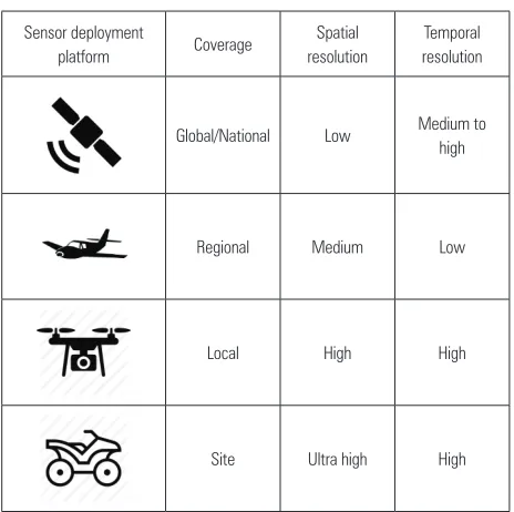
area of coverage per deployment, and the spatial and temporal resolution (Table 1).
Table 1 General characterisation of sensor deployment platform to spatial coverage and temporal resolution (adapted from Pierzchała (2017))
Sensor deployment
platform Coverage
Spatial resolution
Temporal resolution
Global/National Low Medium to high
Regional Medium Low
Local High High
Site Ultra high High
Furthermore, there are two main areas within which remote sensing technologies can be discussed:
those relating to the operating environment
those relating to forest operations themselves. The operating environment determines the selec-tion and use of machine systems, while the second
area deals with issues influencing e.g. productivity or
data capture during the actual operations.
en-able large contiguous forest areas to be mapped in a uniform way (Rahlf et al. 2014), forming a basis for the
development of efficient planning systems. The utility
of using ALS forest and terrain data in harvest plan-ning is discussed by Akay et al. (2009) and Heinimann and Breschan (2012), both of whom emphasize the
benefits of the high resolution digital elevation models
(DEMs) that have become available. These high reso-lution elevation models, with one or more point refer-ences per m2, have revolutionised the basis for
evaluat-ing harvest system accessibility and performance analysis, enabling the use of high precision methods.
The proximal measurement of the forest operations environment (trees and terrain) commonly utilises Li-DAR and/or photogrammetry, but the platforms used
in deploying them differ and the data resolution is
generally considerably higher due to the close proxim-ity. Ground-based measurement provides vertical in-formation on the stem that is not possible to obtain from the air. Examples of the use of terrestrial laser scanning (TLS) in doing pre-harvest tree and stand level assortment bucking have been demonstrated by e.g. Ducey et al. (2013) and Kankare et al. (2014). The stem proportions derived from TLS have been shown to correspond well with stem measurements obtained
from the harvesting head (Astrup et al. 2014). Better
information on stand-level assortments is useful in estimating the stumpage value of a stand and can be sourced in matching orders with harvest schedules in precision wood supply (Bergdahl et al. 2003).
Terrestrial platforms include the deployment of stationary sensors, sensors on manned or unmanned ground-based vehicles (UGVs), or on humans (Laut-erbach et al. 2015, Bauwens et al. 2016, Rönnholm et
al. 2016). Terrestrial deployment platforms often utilise the same sensors as aerial applications, but differ in
terms of costs, payloads, energy sources, and resolu-tion. The forest canopy poses a considerable challenge for terrestrial forest mapping (Blum et al. 2016). Ground-level surveying in forests with the use of GNSS is limited due to signal occlusion caused by dense crowns (Wing and Eklund 2007). This occlusion results in multipath error and discrete »jumps« in po-sition estimates, making high accuracy popo-sitioning
challenging, even with a differential global positioning
system (DGPS) (Naesset and Jonmeister 2002, Sawa-guchi et al. 2003).
Imaging sensors can be deployed on ground plat-forms either on vehicles intended for data capturing
(mobile mapping) or on forestry equipment itself. An
example is the sScale system from Dralle AS (Dralle and Tarp-Johansen 2010), which is an imaging system that can be mounted on a vehicle to measure timber
piles, or the use of ATVs or UGVs for stand and tree-level measurement and inventory (Öhman et al. 2008,
Miettinen et al. 2010, Liang et al. 2014). The harvester
head itself is used as a sensor platform to measure tree sizes, and Kauhanen (2008) improved this functional-ity with image based data.
When properly calibrated, harvesting heads accu-rately measure diameter at 10 cm intervals along the entire stem length, and, with hundreds of millions of trees being harvested with CTL technology annually, harvesting heads represent a central data collection hub. Immediate uses of such data include local estima-tions of growth, and yield data at sub-stand level and
the development of spatially explicit stem taper equa
-tions (Olivera and Visser 2016). Such data are auto -matically geo-referenced at the resolution achieved by the harvester GNSS. An area of great potential that
remains to be fully solved is finding methods for
matching single-tree data from ALS with that of the harvester head, as discussed by Lindroos et al. (2015) and Hauglin et al. (2017). Currently, certain harvester brands provide an estimate of the harvester head posi-tion relative to the base machine, calculated from hy-draulic cylinder extension measurements and crane geometry. Improvements in absolute single-tree preci-sion are, therefore, fully dependent on the accuracy of the GNSS data on the base machine. While this could be resolved with DGPS systems, the practical interim solution is likely to lie in the statistical segmentation
of individual trees out of small groups identified in the
immediate vicinity (Holmgren et al. 2012).
1.2 Infrastructure planning, construction and monitoring
Airborne LiDAR provides high-resolution ground terrain models that represent a considerable improve-ment on which to base estimations on something so detailed and costly as road planning, construction and maintenance. To this end, Aruga et al. (2005a) devel-oped a forest road design programme based on a Li-DAR digital elevation model (DEM) that could opti-mize the horizontal and vertical alignment of a road segment through the minimisation of construction and maintenance costs, using a tabu-search heuristic. Ex-panding on that, both Akay and Sessions (2005) and Aruga et al. (2005b) show how the addition of a
mod-el for predicting surface run-off from roads, which has
important connotations both for environmental im-pact and for road maintenance, provide additional depth to the potential areas of application of the meth-od. Contreras et al. (2012) demonstrate a model using a high resolution LiDAR derived DEM (1 m) to
-ical roads. The detailed DEM made it possible to use a higher number of cross sections in the evaluation
than otherwise, resulting in differences in estimates of
2–21%, as compared with conventional planning. Several applications of airborne LiDAR data in the monitoring and evaluation of existing forest roads have been demonstrated. Craven and Wing (2014)
considered the influence of 4 different canopy condi -tions on the accuracy of estimation of road geometry based on LiDAR data, and showed mean vertical error of 0.28 m and horizontal error of 1.21 m, when consid-ered against existing road centrelines. Road slopes were estimated to within 1% and error in horizontal curve radii was estimated with an absolute error of 3.17 m. The follow up work by Beck et al. (2015) used varying intensity values and return densities in clas-sifying roads and demonstrated a high level of accu-racy in doing so. In other applications, LiDAR has been used in detecting, monitoring or extracting the geometry of existing roads to evaluate whether they
meet certain specifications. For instance White et al.
(2010) extracted alignment and gradient data from a mountain forest road, showing deviations of 1.5 m in position, 0.5% in slope and 0.2% in terms of length
when compared with field survey data. A similar ap -proach applied by Azizi et al. (2014) resulted in more
than 95% of the road length being classified within 1.3 m of the field surveyed normal. These develop
-ments represent considerable time and effort savings
in providing detailed road geometry, providing
essen-tial complementary data to conventional field surveys.
However, Krogstad and Scheiss (2004) list pitfalls of a blind adoption of these models including inconsistent data returns depending on canopy density and a re-sultant data smoothing that can provide a false basis for road design, as well as subsurface issues not
re-flected in the topography.
Beyond planning, construction and the retrieval of road geometry data, monitoring forest road conditions includes gathering information on their surface condi-tion, the condition of the drainage system, the exis-tence of vegetation, and seasonal damage. Existing roads represent partially open areas, which typically results in higher resolution LiDAR ground returns than under the forest canopy, which is the most com-mon case for road planning. In their work on road
quality control, Kiss et al. (2015) show the effect of
resolutions ranging from 0.1 m to 2.0 m on the ability to correctly assess various parameters. Even at the
lowest resolution, road surface was correctly classified
in 66% of the cases, while ditches were correctly
clas-sified in 60% of the cases. Gaining an overview of the
existence and condition of proper drainage is
obvi-ously of prime importance, although this is a
dynam-ic factor and diffdynam-icult to capture at the low temporal scale offered by airborne LiDAR.
There are also examples of higher resolution prox-imal road surface and road geometry modelling.
Sven-son and Fjeld (2016) applied a profilograph, a vehicle
based system with LiDAR scanners, IMU and GPS, in extracting surface roughness and road geometry from a 320 km long stretch of mixed road classes. The de-rived information was used to predict fuel consump-tion and derive preferred routes during timber haul-ing (Svenson and Fjeld 2016). At a slightly lower
resolution, Hrůza et al. (2016) demonstrated the use of
a UAV and photogrammetry in assessing the condi-tion of the wearing course of a forest road. Experi-ences gained in that study led the authors to recom-mend the use of mobile terrestrial systems as preferential for this type of work.
1.3 Machine access planning and layout
Machine access planning is largely about support-ing decisions on which harvestsupport-ing system to deploy and how best to go about doing that. Procedures for ground based harvesting and their potential for
ex-ploiting remotely sensed data are somewhat different
than for cable harvesting, but both work toward
max-imising efficiency and minmax-imising external impacts.
1.3.1 Ground based harvesting
Ground based harvesting is typically carried out with a cut-to-length (CTL) system (harvester and for-warder) or tree-length system
(feller-buncher/skid-der). Optimal planning of how the skid trails should
be laid out is determined to a large degree by topog-raphy and soil bearing capacity. Examples of the use of LiDAR derived elevation models in doing this
in-clude Søvde et al. (2013), who used heuristics in find -ing extraction trails for a forwarder while restrict-ing the degrees of pitch and roll through a cost penalty,
and Strandgard et al. (2014), who assess the influence
of slope on the productivity of a self-levelling proces-sor. Sterenczak and Moskalik (2015) optimise a forest skid trail network through a novel combination of tree segmentation and terrain analysis, where the trees
identified in the ALS dataset were used in estimating
loads, while the gaps were used as potential nodes in the trail network. The model presented by Contreras et al. (2016) extends on these concepts, and includes the evaluation of a soil recovery cost in determining trail layout. However, despite the high resolution of LiDAR based terrain models as compared with their predecessors, and the detailed micro-slope maps they
-timates of surface unevenness. Surface unevenness remains one of the most critical factors determining accessibility and productivity of ground based har-vesting systems and is currently more easily measur-able in a post-harvest context.
Proximal scanning also shows strong potential in providing decision support during operations, for ex-ample in rapid detection of stand density and tree po-sitions, assisting with thinning tree selection (Brunner and Gizachew 2014), allowing for data to be collected on individual tree selection by harvester operators (Brunner and Fredriksson 2012), or modelling which tree the operator might select beforehand (Fredriksson 2010). An overview of how remote sensing data can be used in improving the productivity of mechanised harvesting systems is provided by Alam et al. (2012).
1.3.2 Cable based harvesting
Planning of cable yarding corridor layout must maximise the utilisation of each machine setup while considering the suitability of load paths. Before the advent of LiDAR derived terrain models, desktop planning risked missing critical terrain points as it was not possible to discern the actual terrain form between contour lines, making it necessary to perform manual
profile surveys in order to confirm the degree of de
-flection attainable in each span. Also, the surveyor
needed to make an »a priori«listing of profiles to mea -sure, as only a smaller sample of the site could be cov-ered practically. Detailed LiDAR derived terrain mod-els (1 pt.m-2) now allow for complete analysis of
harvesting sites to be made. Examples of such use have been demonstrated by Søvde et al. (2015), who search for the optimal location of landings, and Dupire et al. (2015), who use LiDAR DTMs to predict the load path in a given corridor.
However, terrain alone does not determine the op-timal layout of the cable corridor, as the location of suitable end trees (tail spars) and intermediate support
trees also need to be verified. The pre-selection of these
from LiDAR data has been shown to be both possible
and effective (Scheiss 2005). Furthermore, Heinimann
and Breschan (2012) describe how LiDAR can be used in gaining volume estimates for each planned cable corridor, a process which could ultimately feed back into the cable layout algorithms presented by (Dupire et al. 2015 and Søvde et al. 2015).
For both ground-based and cable harvesting, the
identification of suitable landings is an important part of harvest planning. Complex spatial patterns can be
determined from LiDAR data (Risbøl et al. 2014), and one related task is the detection and assessing of po-tential landings in terms of area, shape, and surface
evenness (Søvde 2015). This makes it possible to esti-mate their proximity to forest roads, and their suit-ability in terms of wetness and other potentially det-rimental factors.
1.4 Avoiding or measuring soil disturbance Arguably one of the most significant applications
of LiDAR derived terrain models has been in facilitat-ing the mappfacilitat-ing of areas of anticipated high moisture and, therewith, potentially high susceptibility to soil damage by vehicles. The topographic wetness index
(TWI) essentially quantifies the influence of topogra -phy on hydrological processes on the basis of slope and upstream contributing area, and can be best
visu-alised as representing flow accumulation. Cartograph -ic Depth-To-Water (DTW) algorithms on the other hand basically indicate the anticipated vertical dis-tance between ground water or open water surfaces at any given point in the surrounding terrain. Both have shown to be robust in delineating soil, vegetation and drainage type (Murphy et al. 2011) and are increas-ingly used in applications of high relevance to forest operations, such as assessing accessibility and the risk
of causing rutting and compaction (Murphy et al.
2008). Ågren et al. (2014) found that both provided useful soil wetness predictors but that TWI delinea-tions are sensitive to scale and landscape variadelinea-tions, while DTW produces a resolution-consistent wet-area delineation. Campbell et al. (2013) evaluated the use of DTWin predicting rut depth on a high resolution DEM and found good consistency although this has
not yet been effectively demonstrated in forestry. Chal -lenges remain in determining the scale of analysis,
satisfactorily including effects of soil texture and geol -ogy and handling seasonal conditions (Ågren et al.
2015) or even daily variations in machine-specific for
-est soil trafficability (Vega-Nieva et al. 2009). For ex -ample, Niemi et al. (2017) achieved soil damage pre-diction accuracies of over 85% when including an existing soil map in their wetness index calculations. These indices constitute a considerable improvement to forest management data, especially when combined with mathematical programming based decision sup-port systems such as BeST Way in showing the optimal layout of main access trails, as shown by Westlund et al. (2015). In a further step, Pohjankukka et al. (2016) demonstrate the use of machine learning in avoiding
soft areas, as bearing capacity known at given control
for-est machines. The notion of machines sharing such information for a given site has already been put for-ward by Ala-Ilomäki et al. (2012).
The measurement of wheel rut depth after for -warding has been shown to be feasible with
photo-grammetry (Haas et al. 2016, Pierzchała et al. 2016),
however, there remain a number of challenges to using
the method effectively. If not measured iteratively, the
original soil surface needs to be estimated and inter-polated from the adjacent margin, which may not al-ways be accurate. Also, photogrammetry generates a surface model and not a terrain model, which can re-sult in problems in distinguishing between e.g. a brash mat, surface water, and the real soil surface.
1.5 Improving information on key cultural and biological features in avoiding damage
A central part of planning and executing forest op-erations lies in avoiding change or damage to cultural remnants, special habitats, or the transgression of property borders. Remote sensing and especially
air-borne LiDAR has the potential for providing better
geographic information on the key features of impor-tance in forest operations planning and execution. Li-DAR has been used in the detection of cultural heri-tage sites (Risbøl et al. 2014). The use of LiDAR has also shown to have some success in habitat character-ization (Vierling et al. 2008, Sverdrup-Thygeson et al. 2016), where, with improvements in predictability, the segmentation and the delineation of boundaries
indi-cating areas to avoid or treat differently, may yet be -come a mainstream part of harvest planning. By pro-viding such polygons on high resolution DEMs, methods can be developed to calculate the operations cost taking regard of special biotopes (Søvde et al. 2014), in providing forest managers and society at
large with a quantitative tool on which decisions can
be based.
1.6 Autonomous machines, machine navigation and vision
The use of autonomous or remotely operated ma-chines has gained a solid foothold in applications from agriculture to open-cast mining (Mousazadeh 2013). Forestry brings a special set of challenges, most nota-bly a complex operating environment with poor GNSS coverage, and operation in an environment that is open to the public, and therefore subject to demanding
safety requirements. Nevertheless, there are good rea -sons for pursuing the development of autonomous machines, not least the social (isolated work environ-ment) and economic (one operator can control
multi-ple machines) benefits offered (Hellström et al. 2009).
Given the limited GNSS coverage available under tree canopies, other localization approaches such as Simul-taneous Localization and Mapping (SLAM), which
attempts to locate the machine with reference to its
surroundings, while simultaneously mapping its
sur-roundings, offer some potential for the future. These
concepts have been demonstrated on forest machines
(Miettinen et al. 2007, Öhman et al. 2008, Tang et al. 2015). Onboard sensors, such as 2D LiDAR scanners,
radars and stereo-cameras, are essential in providing navigational support for autonomous machines. In a step toward fully autonomous forwarding, Ringdahl et al. (2011) were able to demonstrate accurate path tracking in repeating a route already traversed,
al-though this did include a significant GNSS compo -nent. With regard to application of machine vision and
sensor fusion in forest operations, Pierzchała (2017)
demonstrated the use of cameras, an accelerometer, IMU and GNSS unit in identifying work phases in a cable logging operation, Lideskog and Karlberg (2016)
used machine vision techniques to develop strategies for efficient mound positioning in connection with soil scarification, while Matej (2014) used computer vision
in determining the tilt angle of a forest machine, based on the assumption that tree stems it was imaging were vertically orientated.
2. Conclusions
This review presented a range of current
applica-tions of remote and proximal sensing techniques and
their relevance to forest operations. Forest inventory is now routinely carried out with LiDAR in an
opera-tional setting, and in this way directly impacts the
planning and implementation of forest operations. A
fundamental issue identified throughout the review
was that, while many papers demonstrate new meth-ods or applications for utilising remotely and proxi-mally sensed data, these methods were not necessar-ily mature or used in an optimal combination, and there remains a series of challenges to realising almost all the applications discussed. In the same light, the review shows that the potential for making improve-ments and operationalizing some of the developed
approaches and techniques is considerable and should
be a focus of forest operations research in the years to come.
The development of remote and proximal sensing
technology and techniques will provide a previously
which to extract useful information. These data can, with the application of sensible analytical approaches,
provide significant opportunities for decision support
as well as operations monitoring and evaluation. At the same time, these possibilities will challenge the forest operations researcher with demands on ex-ceptional skills related to data analysis. The approach
to answering new research questions will change from
one of gathering data to one of how to use the vast
amounts of freely generated data effectively. The forest
operations researcher of the future will, in addition, be
required to have a certain degree of expertise related
to sensors and connectivity of such sensors, described as the internet-of-things. Also, together with remotely and proximally measured big-data come special de-mands with regards to ethics and data security. De-tailed forest and personal information related to land owners, managers, forest contractors, machine opera-tors, forest workers and researchers will be instanta-neously accessible via the internet, and protocols for
the generation and handling of this data will require
continuous modernisation.
Finally, it is anticipated that procedures for incor-porating remotely sensed cultural heritage, environ-mental, and biological data will be continually devel-oped as they become a central part of harvesting planning in the future.
Acknowledgements
This paper was written with financial support from
the Norwegian Research Council through the project Sustainable Utilization of Forest Resources in Norway (225329/E40) and the H2020 Bio-Based Industries sup-ported project, TECH4EFFECT (Grant Agreement No. 720757).
3. References
Akay, A.E., Oğuz, H., Karas, I.R., Aruga, K., 2009: Using
LiDAR technology in forestry activities. Environmental Mon-itoring and Assessment 151(1): 117–125.
Akay, A.E., Sessions, J., 2005: Applying the Decision Support System, TRACER, to Forest Road Design. Western Journal of Applied Forestry 20(3): 184–191.
Ala-Ilomäki, J., Lamminen, S., Sirén, M., Väätäinen, K., Asikainen, A., 2012: Using harvester CAN-bus data for mo-bility mapping. Proceedings of the Nordic Baltic conference
on forest operations – OSCAR. Lazdina, D., Jansons A., Kon -stantinova, I. Riga, Latvia, LSFRI Silava 25(58): 85–87. Alam, M.M., Strandgard, M.N., Brown, M.W., Fox, J.C., 2012: Improving the productivity of mechanised harvesting sys-tems using remote sensing. Australian Forestry 75(4): 238– 245.
Aruga, K., Sessions, J., Akay, A.E., 2005a: Application of an airborne laser scanner to forest road design with accurate earthwork volumes. Journal of Forest Research 10(2): 113– 123.
Aruga, K., Sessions, J., Miyata, E.S., 2005b: Forest road design with soil sediment evaluation using a high-resolution DEM. Journal of Forest Research 10(6): 471–479.
Astrup, R., Ducey, M.J., Granhus, A., Ritter, T., von Lüpke,
N., 2014: Approaches for estimating stand-level volume us-ing terrestrial laser scannus-ing in a sus-ingle-scan mode. Canadian Journal of Forest Research 44(6): 666–676.
Azizi, Z., Najafi, A., Sadeghian, S., 2014: Forest road detection
using LiDAR data. Journal of Forestry Research 25(4): 975– 980.
Bauwens, S., Bartholomeus, H., Calders, K., Lejeune, P., 2016: Forest inventory with terrestrial LiDAR: A comparison of static and hand-held mobile laser scanning. Forests 7(6), 127.
Beck, S.J., Olsen, M.J., Sessions, J., Wing, M.G., 2015: Auto -mated Extraction of Forest Road Network Geometry from Aerial LiDAR. European Journal of Forest Engineering 1(1): 21–33.
Bergdahl, A., Örtendahl, A., Fjeld, D., 2003: The economic potential for optimal destination of roundwood in North
Sweden–Effects of planning Horizon and delivery precision.
International Journal of Forest Engineering 14(1): 81–88. Blum, R., Bischof, R., Sauter, U.H., Foeller, J., 2016: Tests of
reception of the combination of GPS and GLONASS signals
under and above forest canopy in the Black Forest, Germany, using choke ring antennas. International Journal of Forest Engineering 27(1): 2–14.
Brunner, A., Fredriksson, C., 2012: A thinning model describ-ing individual tree selection by harvester operators. Manu-script.
Brunner, A., Gizachew, B., 2014: Rapid detection of stand density, tree positions, and tree diameter with a 2D terres-trial laser scanner. European Journal of Forest Research 133(5): 819–831.
Campbell, D.M.H., White, B., Arp, P.A., 2013: Modeling and
mapping soil resistance to penetration and rutting using
LiDAR-derived digital elevation data. Journal of Soil and Water Conservation 68(6): 460–473.
Contreras, M., Aracena, P., Chung, W., 2012: Improving Ac-curacy in Earthwork Volume Estimation for Proposed Forest Roads Using a High-Resolution Digital Elevation Model. Croatian Journal of Forest Engineering 33(1): 125–142.
Contreras, M.A., Parrott, D.L., Chung, W., 2016: Designing
Skid-Trail Networks to Reduce Skidding Cost and Soil
Dis-turbance for Ground-Based Timber Harvesting Operations.
Forest Science 62(1): 48–58.
Craven, M., Wing, M.G., 2014: Applying airborne LiDAR for forested road geomatics. Scandinavian Journal of Forest Re-search 29(2): 174–182.
Ducey, M.J., Astrup, R., Seifert, S., Pretzsch, H., Larson, B.C.,
Coates, K.D., 2013: Comparison of forest attributes derived
from two terrestrial LiDAR systems. Photogrammetric Engi-neering & Remote Sensing 79(3): 245–257.
Dupire, S., Bourrier, F., Berger, F., 2015: Predicting load path and tensile forces during cable yarding operations on steep terrain. Journal of Forest Research 21(1): 1–14.
Fardusi, M.J., Chianucci, F., Barbati, A., 2017: Concept to Prac-tice of Geospatial-Information Tools to Assist Forest Manage-ment and Planning under Precision Forestry Framework: a review. Annals of Silvicultural Research 41(1): 3–14.
Fredriksson, C., 2010: Modellering av skördarförarens träd-val vid gallring. Master, Universitet for miljø- og bioviten-skap.
Gallo, R., Grigolato, S., Cavalli, R., Mazzetto, F., 2013:
GNSS-based operational monitoring devices for forest logging ope-ration chains. Journal of Agricultural Engineering 44(2s): 140–144.
Gobakken, T., Bollandsås, O.M., Næsset, E., 2015: Comparing
biophysical forest characteristics estimated from photogram-metric matching of aerial images and airborne laser scanning data. Scandinavian Journal of Forest Research 30(1): 73–86.
Haas, J., Ellhöft, K.H., Schack-Kirchner, H., Lang, F., 2016: Using photogrammetry to assess rutting caused by a for
-warder–A comparison of different tires and bogie tracks. Soil
and Tillage Research 163: 14–20.
Hauglin, M., Hansen, E.H., Næsset, E., Busterud, B.E.,
Gjevestad, J.G.O., Gobakken, T., 2017: Accurate single-tree
positions from a harvester: a test of two global satellite-based positioning systems. Scandinavian Journal of Forest Re-search: 1–8.
Heinimann, H.R., Breschan, J., 2012: Pre-harvest assessment based on LiDAR data. Croatian Journal of Forest Engineering 33(2): 169–180.
Hellström, T., Lärkeryd, P., Nordfjell, T., Ringdahl, O., 2009:
Autonomous Forest Vehicles: Historic, envisioned, and state-of-the-art. International Journal of Forest Engineering 20(1): 31–38.
Holmgren, J., Barth, A., Larsson, H., Olsson, H., 2012: Predic
-tion of stem attributes by combining airborne laser scanning
and measurements from harvesters. Silva Fenn 46(2): 227– 239.
Holopainen, M., Vastaranta, M., Hyyppä, J., 2014: Outlook
for the Next Generation’s Precision Forestry in Finland. For-ests 5(7): 1682–1694.
Hrůza, P., Mikita, T., Janata, P., 2016: Monitoring of Forest
Hauling Roads Wearing Course Damage using Unmanned Aerial Systems. Acta Universitatis Agriculturae et Silvicul-turae Mendelianae Brunensis 64(5): 1537–1546.
Kankare, V., Vauhkonen, J., Tanhuanpää, T., Holopainen, M., Vastaranta, M., Joensuu, M., Krooks, A., Hyyppä, J., Hyyppä, H., Alho, P.,Viitala, R., 2014: Accuracy in estimation of timber assortments and stem distribution – A comparison of
air-borne and terrestrial laser scanning techniques. ISPRS Jour -nal of Photogrammetry and Remote Sensing 97(1): 89–97.
Kauhanen, H., 2008: Close Range Photogrammetry-Struc-tured Light Approach for Machine Vision Aided Harvesting.
Proc. ISPRS XXI Congress, Beijing, China.
Kiss, K., Malinen, J., Tokola, T., 2015: Forest road quality con -trol using ALS data. Canadian Journal of Forest Research 45(11): 1636–1642.
Krogstad, F., Scheiss, P., 2004: The allure and pitfalls of using LiDAR topography in harvest and road design. Joint
Confer-ence of IUFRO 3.06 Forest Operations under Mountainous
Conditions and the 12th International Mountain Logging
Conference Vancouver, B.C.: 1–10.
Lauterbach, H.A., Borrmann, D., Heß, R., Eck, D., Schilling,
K., Nüchter, A., 2015: Evaluation of a backpack-mounted 3D
mobile scanning system. Remote Sensing 7(10): 13753–13781. Liang, X., Jaakkola, A., Wang, Y., Hyyppä, Y., Honkavaara, E., Liu, J., Kaartinen, H., 2014: The Use of a Hand-Held Cam-era for Individual Tree 3D Mapping in Forest Sample Plots. Remote Sensing 6(7): 6587–6603.
Liang, X., Wang, Y., Jaakkola, A., Kukko, A., Kaartinen, H., Hyyppä, J., Honkavaara, E., Liu, J., 2015: Forest Data Collec-tion Using Terrestrial Image-Based Point Clouds From a Handheld Camera Compared to Terrestrial and Personal La-ser Scanning. IEEE Transactions on Geoscience and Remote Sensing 53(9): 5117–5132.
Lideskog, H., Karlberg, M., 2016: Simulated continuous mounding improvements through ideal machine vision and control. Silva Fennica 50(2): article id 1386.
Lindroos, O., Ringdahl, O., La Hera, P., Hohnloser, P., Hell -ström, T.H., 2015: Estimating the Position of the Harvester Head–a Key Step towards the Precision Forestry of the Fu-ture? Croatian Journal of Forest Engineering 36(2): 147–164. Lokers, R., Knapen, R., Janssen, S., van Randen, Y., Jansen, J., 2016: Analysis of Big Data technologies for use in
agro-envi-ronmental science. Enviagro-envi-ronmental Modelling & Software 84:
494–504.
Matej, J., 2014: Determination of forestry machine’s tilt angle using camera and image processing. Computers and Elec-tronics in Agriculture 109: 134–140.
Miettinen, M., Kulovesi, J., Kalmari, J., Visala, A., 2010: New
measurement concept for forest harvester head. Field and service robotics. Springer Berlin Heidelberg: 35–44.
Miettinen, M., Ohman, M., Visala, A., Forsman, P., 2007: Si -multaneous Localization and Mapping for Forest Harvesters. Robotics and Automation, 2007 IEEE International Confer-ence on. IEEE: 517–522.
Mousazadeh, H., 2013: A technical review on navigation
sys-tems of agricultural autonomous off-road vehicles. Journal
of Terramechanics 50(3): 211–232.
Mulla, D.J., 2013: Twenty-five years of remote sensing in pre -cision agriculture: Key advances and remaining knowledge gaps. Biosystems engineering 114(4): 358–371.
Murphy, P.N., Ogilvie, J., Meng, F.-R., White, B., Bhatti, J.S.,
Murphy, P.N.C., Ogilvie, J., Castonguay, M., Zhang, C.-F.,
Meng, F.-R., Arp, P.A., 2008: Improving forest operations
planning through high-resolution flow-channel and wet-ar -eas mapping. The Forestry Chronicle 84(4): 568–574. Naesset, E., Jonmeister, T., 2002: Assessing point accuracy of
DGPS under forest canopy before data acquisition, in the field and after postprocessing. Scandinavian Journal of Forest
Research 17(4): 351–358.
Niemi, M.T., Vastaranta, M., Vauhkonen, J., Melkas, T., Ho-lopainen, M., 2017: Airborne LiDAR-derived elevation data
in terrain trafficability mapping. Scandinavian Journal of For -est Research: 1–12.
Næsset, E., 2004: Accuracy of forest inventory using airborne
laser scanning: evaluating the first nordic full-scale opera -tional project. Scandinavian Journal of Forest Research 19(6): 554–557.
Olivera, A., Visser, R., 2014: Integration of harvester data and
geospatial information. Harvesting technical note HTN07-03. Future Forest Research Ltd. Rotorua, New Zealand.
Olivera, A., Visser, R., 2016: Development of forest-yield
maps generated from Global Navigation Satellite System
(GNSS)-enabled harvester StanForD files: preliminary con -cepts. New Zealand Journal of Forestry Science 46(1): 3.
Pierzchała, M., 2017: Developing the use of imaging technol -ogy for forest operations. PhD, Norwegian University of Life Sciences.
Pierzchała, M., Talbot, B., Astrup, R., 2016: Measuring wheel
ruts with close-range photogrammetry. Forestry 89(4): 383– 391.
Pohjankukka, J., Riihimäki, H., Nevalainen, P., Pahikkala, T., Ala-Ilomäki, J., Hyvönen, E., Varjo, J., Heikkonen, J., 2016: Predictability of boreal forest soil bearing capacity by ma-chine learning. Journal of Terramechanics 68: 1–8.
Rahlf, J., Breidenbach, J., Solberg, S., Næsset, E., Astrup, R., 2014: Comparison of four types of 3D data for timber volume estimation. Remote Sensing of Environment 155: 325–333.
Ringdahl, O., Lindroos, O., Hellström, T., Bergström, D., Athanassiadis, D., Nordfjell, T., 2011: Path tracking in forest
terrain by an autonomous forwarder. Scandinavian Journal of Forest Research 26(4): 350–359.
Risbøl, O., Briese, C., Doneus, M., Nesbakken, A., 2014: Mon -itoring cultural heritage by comparing DEMs derived from historical aerial photographs and airborne laser scanning. Journal of Cultural Heritage 16(2): 202–209.
Rönnholm, P., Liang, X., Kukko, A., Jaakkola, A., Hyyppä, J., 2016: Quality analysis and correction of mobile backpack la-ser scanning data. ISPRS Annals of Photogrammetry, Remote Sensing and Spatial Information Sciences: 41–47.
Sawaguchi, I., Nishida, K., Shishiuchi, M., Tatsukawa, S., 2003: Positioning precision and sampling number of DGPS under forest canopies. Journal of Forest Research 8(2): 133– 137.
Scheiss, P., 2005: The application of spatially explicit digital elevation and canopy surface data for harvest planning: mov-ing from coarse digital elevation models and stand averages
to detailed ground and canopy surface models in the design
of forest transportation systems. Scientific cooperation for forest technology improvement – FORMEC. Ed. B., Košir,
Ljubljana, Slovenia: 52–65.
Sterenczak, K., Moskalik, T., 2015: Use of LIDAR-based digi-tal terrain model and single tree segmentation data for opti-mal forest skid trail network. iForest – Biogeosciences and Forestry 8(5): 661–667.
Strandgard, M., Alam, M., Mitchell, R., 2014: Impact of Slope on Productivity of a Self-levelling Processor. Croatian Journal of Forest Engineering 35(2): 193–200.
Svenson, G., Fjeld, D., 2016: The impact of road geometry and surface roughness on fuel consumption of logging trucks. Scandinavian Journal of Forest Research 31(5): 526–536.
Sverdrup-Thygeson, A., Ørka, H.O., Gobakken, T., Næsset,
E., 2016: Can airborne laser scanning assist in mapping and monitoring natural forests? Forest Ecology and Management 369: 116–125.
Søvde, N., Løkketangen, A., Church, R., Oppen, J., 2015: A
semi-greedy metaheuristic for the European cableway loca-tion problem. Journal of Heuristics 21(5): 641–622.
Søvde, N., Sætersdal, M., Løkketangen, A., 2014: A Scenario-Based Method for Assessing the Impact of Suggested Wood-land Key Habitats on Forest Harvesting Costs. Forests 5(9): 2327–2344.
Søvde, N.E., 2015: Algorithm for estimating the suitability of potential landing sites. Mathematical and Computational Forestry & Natural Resource Sciences 7(1): 1–8.
Søvde, N.E., Løkketangen, A., Talbot, B., 2013: Applicability of the GRASP metaheuristic method in designing machine trail layout. Forest Science and Technology 9(4): 187–194.
Talbot, B. Astrup, R., 2014: Forest Operations and Ecosystems
Services in Norway – a review of the issues at hand and the
opportunities offered through new technologies. Journal of
Green Engineering 4(4): 271–290.
Tang, J., Chen, Y., Kukko, A., Kaartinen, H., Jaakkola, A., Khoramshahi, E., Hakala, T., Hyyppä, J., Holopainen, M., Hyyppä, H., 2015: SLAM-Aided Stem Mapping for Forest Inventory with Small-Footprint Mobile LiDAR. Forests 6(12): 4588–4606.
Tomaštík, J.J., Tomaštík, S.J., Saloň, Š., Piroh, R., 2016: Hori -zontal accuracy and applicability of smartphone GNSS posi-tioning in forests. Forestry: An International Journal of Forest Research 90(2): 187–198.
Vastaranta, M., Latorre, E., Luoma, V., Saarinen, N., Holo-painen, M., Hyyppä, J., 2015: Evaluation of a Smartphone App for Forest Sample Plot Measurements. Forests 6(4): 1179.
Vega-Nieva, D.J., Murphy, P.N.C., Castonguay, M., Ogilvie,
J., Arp, P.A. 2009: A modular terrain model for daily
varia-tions in machine-specific forest soil trafficability. Canadian
Journal of Soil Science 89(1): 93–109.
Visser, R., Raymond, K., Harrill, H., 2014: Mechanising steep terrain harvesting options. NZ Journal of Forestry 59(3): 3–8.
Westlund, K., Rönnqvist, M., Flisberg, P., Friberg, G., 2015:
BeST Way – The next generation of forwarding planning 16th
Symposium for systems analysis in forest resources (SSAFR).
L.O., Eriksson. Uppsala, Sweden, SLU, Skogforsk.
White, R.A., Dietterick, B.C., Mastin, T., Strohman, R., 2010:
Forest Roads Mapped Using LiDAR in Steep Forested Ter-rain. Remote Sensing 2(4): 1120.
Wing, M.G., Eklund, A., 2007: Performance comparison of a low-cost mapping grade global positioning systems (GPS) receiver and consumer grade GPS receiver under dense for-est canopy. Journal of Forfor-estry 105(1): 9–14.
Ziesak, M., Marques, A.F., Rasinmaki, J., Rosset, C., Num
-mila, K., Scholz, J., Mittlboeck, M., Pinho de Sousa, J., Häkli,
J., Rommel, D., 2014: Advances in forestry control and
auto-mation systems i Europe – FOCUS: the concept idea in a
multinational EU research project. Proceedings of the 6th
Precision Forestry Symposium: The anchor of your value chain. P., Ackerman, E., Gleasure and H., Ham. Stellenbosch, South Africa, Faculty of AgriSciences, Stellenbosch Univer-sity: 114 p.
Öhman, M., Miettinen, M., Kannas, I., Jutila, J., Visala, A.,
Forsman, P., 2008: Tree measurement and simultaneous lo-calization and mapping system for forest harvesters. Field
and Service Robotics: Results of the 6th International
Confer-ence. C., Laugier, R., Siegwart 42: 369–378.
Ågren, A., Lidberg, W., Ring, E., 2015: Mapping Temporal Dynamics in a Forest Stream Network—Implications for Ri-parian Forest Management. Forests 6(9): 2982.
Ågren, A., Lidberg, W., Strömgren, M., Ogilvie, J., Arp, P.,
2014: Evaluating digital terrain indices for soil wetness map-ping–a Swedish case study. Hydrology and Earth System Sciences 18(9): 3623–3634.
Received: March 19, 2017 Accepted: June 08, 2017
Authors’ addresses: Bruce Talbot, PhD. * e-mail: [email protected]
Marek Pierzchała, PhD.
e-mail: [email protected] Rasmus Astrup, PhD. e-mail: [email protected]
Norwegian Institute for Bioeconomy Research Department of Forestry and Forest Resources Hoegskoleveien 7
1430 Ås
NORWAY