Prepared by
M/s Pragathi Labs & Consultants PVT. LTD.
(Recognized by MINISTRY OF ENVIRONMENT & FORESTS, GOVT. OF INDIA)
Plot No. B15 &16, Industrial Estate
Behind PCB, Sanath Nagar
Hyderabad - 500 0018
for
Black
Granite
Quarry
2.255
Ha.
of
M/s.Raghavendra
Granites
at
Sy.No.848/1
(549)
of
Krishnagiri
village
&
Mandal,
Kurnool
District
No. Contents Page No.
1.0 Introduction 1
1.1 Mining Technology 1
1.2 Mine Location and its details 1
1.3 Geology 4 1.3.1 Topography 4 1.3.2 Regional Geology 5 1.3.3 Local Geology 5 1.3.4 Litho Units 6 1.3.5 Geological Plan 6
2.0 Estimation of Geological Reserves 6
2.1 Reserves 6
3.0 Production Details 7
3.1 First Five years of operations 7
4.0 Mining & Methods 7
5.0 Land Use Pattern 8
6.0 Dumping Yard 8
7.0 Dressing 8
8.0 Uses of Granites 9
9.0 Environment Management Plan 9
9.1 Sources of Pollution and Control Measures 9
9.1.1 Air pollution and its control measures 9
9.1.2 Noise Pollution and its mitigation 10
9.1.3 Water Quality 10
10.0 Water Requirement 11
11.0 Solid waste , Land reclamation and soil Conservation 11
12.0 Manpower requirement 12
13.0 Occupational Safety & Health 12
14.0 House Keeping 12
15.0 Transport System 12
16.0 Afforestation Programme and Flora-Fauna 13
16.1 Proposed afforestation 13
16.2 Proposal reclamation of land affected by mining 13
17.0 Environmental Greening Program 13
18.0 Socio Economic Environment 15
19.0 Disaster Planning 15
20.0 Environment Management Cell 16
21.0 Post Project Monitoring 16
22.0 Other Management Aspects 17
List of Tables
No. Name Page. No.
1 Location and Quarry details 2
2 Salient features of the Project 4
3 Production details 7
4 Land use details 8
5 Dumping yard details 8
6 Water Requirement 11
7 Solid waste management details 11
8 Employment details 12
9 List of suggested Plant species for
greenbelt 14
List of Figures
No. Name Page. No.
1.0 Location Map 2
1.0 Introduction
The report discusses the Management plan for mitigation of adverse Environmental impacts and increases the beneficial impacts due to mining.
The environmental impacts can be categorized as either primary or secondary. Primary impacts are those, which are attributable directly to the project, secondary impacts are those, which are indirectly induced and typically include the associated investment and changed pattern of social and economic activities by the proposed action.
The objective of preparing environment management plan is to define effective measures to control and to mitigate the environmental pollution. This report presents the environment management plan, detailing the environmentally sound technology and the measures needed to mitigate the anticipated environmental impacts due to the project.
M/s. Raghavendra granites has been applied for 01st renewal of quarry lease application on 27.11.2009 for Black granite over an extent of 2.255 Ha.
After careful examination of the proposal of Assistant Director of Mines and Geology, in principle has decided to grant the quarry lease for a period of 20 years vide Director of Mines and Geology, W.e.f 02.03.2010 in favor of M/s. Raghavendra Granites vide proceeding No.47868/R4-2-2009, dt.15.03.2010
Mining plan approved by the Joint Director of Mines and Geology, Kadapa vide letter no. 340/MP-KNL/2010, Dt. 30.01.2010.
01st scheme of mining was approved by the mines & geology vide letter no.2994/MS-KNL/2015, Dt.19.11.2015
1.1 Mining Technology
Opencast Semi mechanized method of mining is carried out in this mine and semi mechanization by using compressor operated jackhammers and poclain etc. Transportation will be made by trucks to dispatching point.
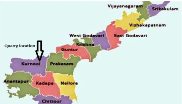
1.2 Mine Location and its details
The proposed site is falling Kurnool district of Andhra Pradesh is depicted below (Fig.1.0)
Fig.1.0 Location Map
The project locations and client details are summarized as follows Table 1.0 Project location and Quarry details
Description Details
Name of the Project M/s. Raghavendra granites Black granite existing Quarry
Survey Number 657/1
Latitude and longitude Latitude Longitude
150 34 7.60’’ N 770 48’ 49.10’’ E 150 34 11.24’’ N 770 48’ 51.77’’ E 150 34 5.70’’ N 770 48’ 43.50’’ E 150 34 7.54’’ N 770 48’ 53.49’’ E 150 34 5.57’’ N 770 48’ 48.97’’ E 150 34 9.79’’ N 770 48’ 48.06’’ E
Name of village Krishnagiri
Mandal Krishnagiri District Kurnool
State Andhra Pradesh
Registered address Sri.K. Venkateswarlu - Managing partner H.No. 86-335, Doctors colony,
Kurnool -518 002. Andhra Pradesh Mob. No. 9848136662
040-23717213
Production 878 m3/annum
Area of the Mine 2.255 Ha.
Proponent Sri.K. Venkateswarlu - Managing partner
Fig.1.1 Topographical map of 10 km radius around the proposed Quarry
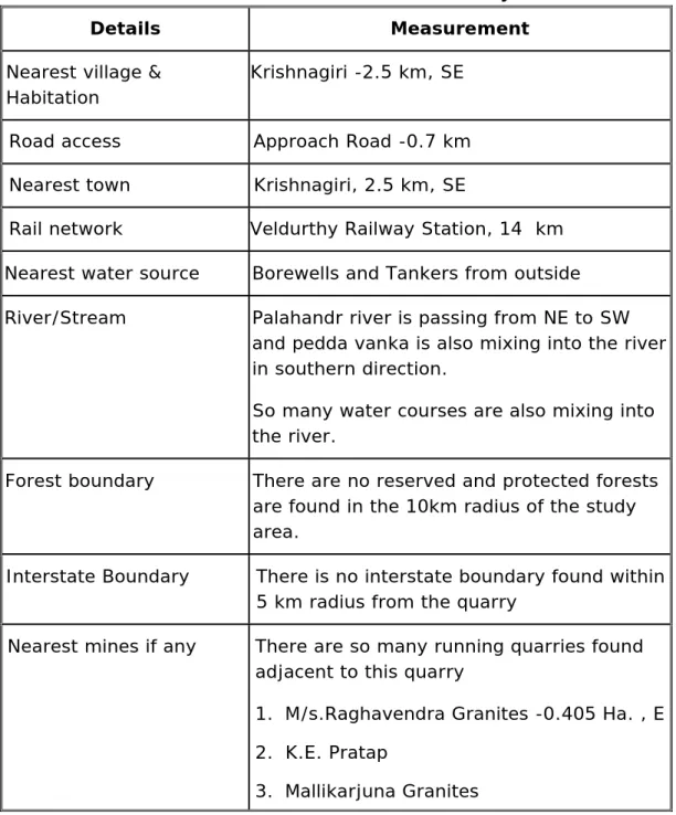
Table 2.0 Salient features of the Project
Details Measurement
Nearest village & Habitation
Krishnagiri -2.5 km, SE
Road access Approach Road -0.7 km
Nearest town Krishnagiri, 2.5 km, SE
Rail network Veldurthy Railway Station, 14 km
Nearest water source Borewells and Tankers from outside
River/Stream Palahandr river is passing from NE to SW
and pedda vanka is also mixing into the river in southern direction.
So many water courses are also mixing into the river.
Forest boundary There are no reserved and protected forests
are found in the 10km radius of the study area.
Interstate Boundary There is no interstate boundary found within
5 km radius from the quarry
Nearest mines if any There are so many running quarries found
adjacent to this quarry
1. M/s.Raghavendra Granites -0.405 Ha. , E
2. K.E. Pratap
3. Mallikarjuna Granites
1.3 Geology
1.3.1Topography
Topographically the area proposed for grant of is a predominant hillock gemtly slopes towards all directions. Generally it is low lying plain land with an average altitude of 305 m above MSL and dendritic to sub dendrotic drainage is observed. The area is elevated towards centre of the hillock and sloping towards in all directions. The area is devoid of any forest or tree cover. It comprises shrubs only.
There are no prominent natural drainage chennels in the area. In general the area is plain land.
1.3.2 Regional Geology
The dolerite is intruded into the pre-existing country rock namely Biotite Gneisses and schist and trending from East to West direction and dipping vertical. The width of dyke is about 50-73m and running to few kilometers. The colour of black granite is dark black with more melanocratic minerals like Augite than plagioclase feldspars. No mica of iron is found. The texture is uniform with massive outcrops as sheets. The order of superposition of geological sequence are given as under
Description Geological Age
Top soil –Red Recent Age
Dolerites Archaean
Peninsular gneisses Archaean
Biotite gneisse is the oldest rock into which the younger dolerite dykes intruded later.
1.3.3 Local Geology
Dolerite is commercially called as Black granite by the quarry operators and buyers. It is a type of of ferro-magnesian dyke rock comprised of mineral constituents such as Pyroxene (Augite and Hypersthene) and Plagioclase More Plagiocalse and Augite provide grey/greenish black colour up on polishing to this rock. The texture is a typical porphyritic, with phenocryst of plagioclase embedded over pyroxene matrix.The rock is fine to medium grained melanocratic and without any segregation or testural defects, but more bouldary due to spheroidal weathering.This spheroidal weathering cause for more rejection up to 5-6m depth and hence rate of recovery is taken 10% below the bouldary layer. Dimensional cutting polishing of these type of hard nad compact massive rocks exibits an attractive greenish black colour an attain polishing. The strike of the deposit is more than 500 m with 70-80 width.The average width at the top/middle is measured as 73 m. kardness ranging from 6.5-7.5 (Moh’s scale) specific gravity 3-3.30 gms/cc and attain high polishing which create an excellent aesthetic value.
The area applied for quarry lease contains Dolerite Dyke intruded into the country rock comprising Biotite gnesses. The small pegmatite was reported to be intruded between these two formations. The dyke is partly covered by red soil. The length and width of band in the lease hold area is measured as about 400m×50-73m and dips vertical. The top soil is very thin less than 1 m but the
boulders are expected to be extended up to 5 m below top soil due to spheroidal weathering.
The mineral constituents of the rock mass are augite 705, plagioclase 25 % and others 5 % as identified magascopically.The order of geological sequence are.
Top soil red -<1 m thick-Recent
Pegmatite -Archean
Dolerites -Archean
Peninsular gneisses -Archaean
Biotite gneisses is the oldest rock into which the younger dolerite dykes intruded later followed by pegmatite over weak zones. The strike direction is measured as East to West direction and drops vertical. Normally dyke deposit with more than 25m thick will be more of sheet in nature and economical at high profit margin to produce gang saw size rough blocks.
1.3.4 Litho Units
Minerologically the Granite consists of Quartz, Plagioclase feldspar as essential mineral and other mafics Boitite, Mica, hornblend, etc., as accessory mineral with fine to medium grain. The Granite Exhibits gneissic texture with alternate bands of felsic and mafic minerals arranged in a wavy pattern. The mafic minerals are observed in more content hence the rock is melaocratc. The Granite available in the demarcated area is useful for Granite cutting and polishing purpose
The QL applied area may yield a good deposit of granite, which shows uniform in grain size less mafic and widely saced joints.
1.3.5 Geological plan
The area recommended for the grant of Quarry Lease was initially demarcated on the village revenue map. Subsequently the area was surveyed using theodolite/GPS and a contour base plan was prepared based on 1:1000 scale and local geology was plotted and given in geological Plan.
2.0 Estimation of Geological Reserves 2.1 Reserves
• Total net Mineable Reserves of black Granite in QL area = 32872 m3
• Total Mineral waste available in QL applied area = 241061 m3
Life of the Quarry
Mineable Reserves / Annual production =32872/10,668 =37 years.
3.0 Production Details
The year wise production details are summarized in the following Table 3.0 Table. 3.0 Production Details (2015-2020)
Year Production m3 Granite (16%) Waste (84%) 1st Year 1205 6325 2nd year 1161 6098 3rd year 1161 6098 4th year 1161 8981 5th year 1161 6098 Total 5849 33600
The summary of the mine production and reserves are given in the following Table Description Details Minerals occurring in the
area
Black Granite Mine
Production 878 m3/annum
Proved (m3) 46329
Probable (m3) 10431
Possible (m3) 10431
Total Reserves (m3) 67191
Total reserves after buffer zone (m3)
34441
3.1 First five years of operations
Total rock mass will be Excavated = 39,449 m3
Ore: Waste = 16:84
Granite blocks will be recoverable from rock mass = 5849 m3 (16%)
Remaining material is mineral waste = 33600 m3 (86%)
4.0 Mining and Methods
Type of Mining: Semi mechanized opencast method
In AMP it was proposed to be carried out the mining of black granite with the help of digging tools like excavator, tippers, Compressors and jackhammers.
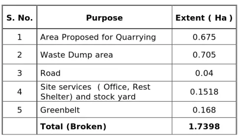
5.0 Land use Pattern
The following table shows the Land Breakup for the next Five years of mining.
Table 4.0 Land use details
S. No. Purpose Extent ( Ha)
1 Area Proposed for Quarrying 0.675
2 Waste Dump area 0.705
3 Road 0.04
4 Site services ( Office, Rest Shelter) and stock yard 0.1518
5 Greenbelt 0.168
Total (Broken) 1.7398
6.0 Dumping Yard
The applicant has demarcated plots of land, to dump all types of solid wastes generated during mining operations. The dump yard fairly uneven ground, single dump yard is proposed with in the lease area where all the waste will be dumped. It is pertinent to note that nearly 85% of what is quarried will go as waste and only 15% will be made up of marketable quality product.
Table 5.0 Dumping Yard details
1 Dump Area (m2) 7050
2 Direction N & S
3 Dimensions (LXbXh) m 470X15X10
4 Waste Generated (next 5 Years)
(86%) m3
33600 5 Waste generated during life of
mine (20 Years)
1,34,400
6 Slope 1 in 20
7 Retaining wall 1.2X1.2X1.2
7.0 Dressing
The dressing of rough blocks will be made by chipping the edges and equating surface of the block carefully at mine site.
i. Dressing of dimensional rough blocks from the rough blocks obtained after primary export cut need to be dressed. This is done manually / using pneumatic picks. The main aim of dressing is to give good geometrical shape. The dressing also depends upon the rock surface to be exposed after dressing.
ii. Dressing of rough blocks in the quarry for domestic processing plants. The rough blocks sent to processing plants from the mine.
8.0 Uses of Granite
Rough Blocks, Slabs, Panels, Tiles, Monuments, Other fancy and decorative items like pen stand, Flower vases, Table Tops – Tea poys and High precision products like surface plates for engineering applications.
9.0 Environment Management Plan
The environment management plan is prepared with a view to facilitate effective environmental management of the project in general and implementation of the mitigation measures in particular. The EMP provides a delivery mechanism to address potential adverse impacts and to introduce standards of good practice to be adopted for all project works.
The anticipated impacts due to mining and allied activities are air, noise, land, water and socio-economic along with the mitigations to the extent possible are described in the following paragraphs.
9.1 Sources of Pollution and Control measures
The major sources of pollution are air and noise due to proposed mine from blasting and transportation of material to the far places.
9.1.1 Air Pollution and its Mitigation Anticipated Sources of Air Pollution
Digging & Excavation (Dust, Non-fugitive)
Loading & unloading and Transportation by vehicles (fugitive and line
sources
Air Quality Management
Road - Regular repair (every 6 months) and Grading
-Regular water sprinkling on haulage roads during dry conditions
Drilling -Wet drilling and usage of sharper drill bits
vehicles
Movement - Trucks to be covered with tarpaulin/plastic Enforcing speed limit (<25kmph)
Plantation -Green belt development and avenue plantation 9.1.2 Noise pollution and its mitigation
Sources of Noise
1. Loaded trucks movement generates 80- 84 dB (A) (2-3 trucks short time stay at mine area)
2. Digging and excavation activities - 70 dB (A) (Only during day time)
3. Blasting (Occasionally) & drilling- (89 dB (A)), blasting gives only outburst of noise (if required Blasting operations only for few minutes)
4. Normal values when mining is not in operation (40-45 dB (A) Control Measures
• Mining operations will be carried out during day time only and avoid
inconvenience to the nearby habitations
• The noise propagation values found to be less than the prescribed noise
limits
• Ear plugs will be provided to the noise prone areas
• Blasting will be done through controlled methods (occasionally)
• Vehicular maintenance will ensure less noise.
• Usage of sharp teeth on the JCB will reduce noise during loading operations
9.1.3 Water Quality
There are no major water bodies found at a distance 1.0 km from the proposed quarry as the proponent is allocated dump area to accumulate the waste generated from the quarry and retaining wall also will be provided so there is less impact anticipated on the due to proposed quarry.
The rainwater flows through the slopes of the area and drained off through nalas. The ground water table in this belt is 40 m below from the surface and since the quarry depth is 6 m will not reach upto this depth in the near future flooding by ground water is not anticipated. However, during rainy months, there is a possibility of wet conditions developing in the working pit. This will be minimized if not altogether eliminated by adopting simple techniques like digging trenches all round to drain off rainwater and preventing surface run off from entering and flooding working pit. The water will be pumped by using electric motor, if and when required, the mine drainage can be effectively managed and the pit kept dry to keep up the production schedule.
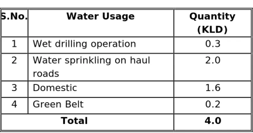
10.0 Water Requirement
Table 6.0 Water Requirement
S.No. Water Usage Quantity
(KLD)
1 Wet drilling operation 0.3
2 Water sprinkling on haul
roads 2.0 3 Domestic 1.6 4 Green Belt 0.2 Total 4.0
Garland drains will be provided around the mine wherever required to arrest any soil from the mine area being carried away by the rain water
11.0 Solid Waste, Land reclamation and soil conservation Table 7.0 Solid waste management details
Purpose Description
Ore : Waste 16:84
Quantity of waste 33600 m3
Area Allocated for dump area
7050 m2
Dump Details ((LXbXh) m 400X15X10
Dumping area N & S Direction
Chemical Nature Non-toxic and will not
dissolve in water
Dust arrest from dumps Top soil coverage and
plantation and control of soil erosion
Usage of dumps Repair of roads during rainy
season and Refill the pits with waste as per abandoning Schedule plan
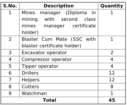
12.0 Manpower Requirement
Table 8.0 Employment Details
S.No. Description Quantity 1 Mines manager (Diploma in
mining with second class mines manager certificate holder)
1
2 Blaster Cum Mate (SSC with
blaster certificate holder)
1 3 Excavator operator 2 4 Compressor operator 4 5 Tipper operator 4 6 Drillers 12 7 Helpers 12 8 Cutters 8 9 Watchman 1 Total 45 13.0 Occupational Safety and Health
Safety precautions as per Metalliferrous mines Regulations and Mine Rules
and Act shall be taken.
Minimum distance of 7.5m will be left all along the mine lease boundary. The
mined out area will be kept out of bounds for public by providing fencing.
Occupational Safety and Health to Control Exposure to Noise
* Reducing the exposure time of workers to the higher noise levels
* Smooth blasting techniques, special explosives and silent non-explosive demolishing agent will be used.
14.0 House Keeping
Proper house keeping and cleanliness will be maintained in the infrastructure facilities. Wet mopping will be adopted to conserve water. Sign boards will be provided in the work areas and the road and building highlighting the safety and occupational aspects.
15.0 Transport Systems
The finished product is transported by road using road trucks. The lessee will deploy tippers to transport the waste blocks, unfinished and finished blocks from quarry site to yard and trucks to transport sized dimensional blocks from yard to destination. Cranes will do the loading of blocks. The materials while transporting
do not pose any hazard. Sufficient parking facilities will be provided for vehicles loading and unloading of material. Safety signs will be displayed inside and outside the mine to avoid road accidents.
16.0 Afforestation Programme and Flora-fauna
Flora and Fauna
Due to water stress conditions and edaphic factors the biomass cover is less.
Tree coverage is less and mostly herbs and shrubs are dominating.
The vegetation is very scarce. No plant species is found that is ecologically
important (Rare, endangered, threatened etc.) restricted to this area.
The loss of biomass can be compensated by providing ideal conditions
(proper supervision, water, fertilizer etc.) for the proposed greenbelt.
Other than domestic animals no ecologically important animals are reported
in this area.
16.1 Proposed afforestation
The soil scraped from the surface will be stored temporarily along the edges of the mine till the complete extraction. This ensures proper preservation and utilization of the soil.
16.2 Proposal for reclamation of land affected by mining
The proposed mining will result in reducing the height of the area and exposing the parent rock. It will be covered with a mantle of soil to serve the dual purpose of utilization of soil and reclaiming the ground affected by mining. The reclamation will commence after the completion of mining activity.
17.0 Environmental Greening Program
Environmental greening program is an important component of the Environment Management Plan and is an imperative requirement for any major industrial activity, as per the guidelines issued by the Ministry of Environment and forests, Govt. of India. Conceptualization, design and implementation of the proposed activity, taking into account the specific requirement of the proposed mining activity and the site conditions are presented.
Each year some of the part of the barrier zone will be subjected to afforestation and care will be taken to protect the sapling. Fruit growing trees are proposed to be planted.
Table 9.0 List of suggested plant species for Green Belt
No. Botanical Name Common
Name Height (m)
Color of the flower
Flowering time
1 Acacia arabica Nalla
thumma
8.0-10.0 Yellow March-May
2 Aegle marmelos Maaredu 8.0-10.0 Greenish
white March-April 3 Albizia lebbeck (A.procera) Diresina 10.0-15.0 Greenish yellow April-May
4 Artocarpus integrifolia Panasa 6.0-8.0 - Feb.-March
5 Anogeissus latifolia Velama 10.0-15.0 Greenish Sept.-Jan.
6 Anacardium
occidentale
Jeedi 3.0-4.0 Cream Jan.-Feb.
7 Anthocephalus
cadamba
Kadambamu 10.0-15.0 Yellow Oct.-Dec.
8 Bauhinia variegata Devakanchan
amu
7.0-8.0 Purple & white
Feb.-April
9 Cassia fistula Reela 9.0-13.0 Yellow March-May
10 Casuarina equisetifolia Sarvi 10.0-15.0 Inconspicuo
us
March-May
11 Delonix regia Peddathurai 8.0-12.0
White-orange
April- June
12 Nyctanthes arbortristic Paarijatha 2.0-3.0 White Oct.-Nov.
13 Lagerstroemia
floreginae
China goranta
7.0-10.0 Liliac May-June
14 Mangifera indica Mamidi 7.0-8.0 White Feb.-March
15 Mimusops elengi Pagada 4.0-5.0 White Nov.-Dec.
16 Nerium odorum Ganneru 2.0-4.0 Red, white Feb.-March
17 Pithecellobium dulce Cheema
chinta
8.0-10.0 White March-April
18 Putranjiva roxburghii Kudhuru 8.0-10.0 Inconspicu
ous
18.0 Socio-economic Environment
For the functioning of the mine approx. 45 manpower will be utilized and it
will not have any significant impact on economy of the local people
It will have indirect benefit to the people of AP in the form of collection of
tax.
0.04 ha of land allocated for road will be laid with avenue plantation along
with lights which will be useful for the local people
No impact due to influx of population/ labour because the mine is very small
19.0 Disaster Planning
The mining operation shall be carried out under the management control and direction of a qualified mines manager holding a Second class manager’s certificate of competency to manage a metalliferous mine granted by Director General of mines safety (DGMS). DGMS have been issuing a number of standing orders and circulars to be followed by the mine management in case of disaster, if any. Moreover mining staff would be sent to refresher courses from time to time to keep them abreast of the regulations. However following natural/ industrial hazards may occur during normal operation
Slope failure at the mine faces
Accident due to explosives
Accident due to heavy equipment/machinery
Sabotage in case of magazine
Accidents due to fly rocks and boulder
In order to take care of above hazards/disasters, the following control shall be adopted:
All safety precautions and provisions of Metalliferous Mine regulation 1961
are strictly followed during all mining operations
Checking and regular maintenance of garland drains and earthen bunds to
avoid any inflow of surface water into mining area
Entry of unauthorized persons shall be prohibited
Fire fighting and first aid provisions in the mines office and mining Area;
Provision of all the safety appliances such as safety boots, helmets, goggles
etc. would be made available to the employees and regular check to ensure the use
Training and refresher courses for all the employees working in the
hazardous premises
Working of mine as per approved plan, related amendments and other
regulatory provisions
Cleaning of mine faces shall be done regularly
competent persons only
Provision of magazine at safe place with fencing and necessary security
arrangement
Suppression of dust on the haulage roads by providing water sprinkling.
20.0 Environment Management Cell
A Cell for Environmental Management within Mine lease area at the project level, will take the overall responsibility for co-ordination of the actions required for environmental management and mitigation, and for monitoring the progress of the proposed management plans and actions to be taken for the project. The Cell will be under the overall supervision of the Mine Manager, and responsible for monitoring of the implementation of the various actions which are to be executed by the agencies specified in the EMP. The Cell will be headed by Mine Manager and the other members of the cell that will include a Horticulturist and 1 no. of supervisor.
The EMC will prepare a formal report on environmental management and mitigation for the Environmental Engineer at the Mine, at six-monthly intervals. Reports on any urgent or significant issues may be prepared at shorter intervals. Apart from responsibilities listed above, the EMC will have the responsibility of the following:
Collection of water and air samples within and outside the work zone
Analyzing the water and air samples
Implementation of the control and protective measures
Land reclamation and vegetation
Co-ordination of the environment related activities
Collection of the statistics of health of workers
Green belt development
Awareness and implementing safety programmes
Monitor the progress of implementation of EMP
21.0 Post Project Monitoring
The survey of air pollution comprises of the following monitoring aspects;
a. Ambient air quality survey
b. Noise Level Monitoring
Ambient air quality and noise level Monitoring will be carried out at minimum three stations, one station within mine site and two stations nearby residential areas outside the mine. Parameters like suspended particulate matter, sulphur dioxide, oxides of nitrogen carbon monoxide and lead will be monitored. The frequency of monitoring is preferably once in three months on 24 hour basis. The samples will be collected in accordance with the procedures given by CPCB.
22.0 Other Management Aspects
Records will be maintained for the analysis of ambient air quality and noise levels. These records are not only required for the perusal of the Pollution Control Board authorities. The management will maintain the records as per the hazardous waste regulations and EPA regulations and apply for the annual consents for air and water, and renewal of authorization for the storage of hazardous waste as per the Hazardous Waste (Handling & Management) Rules, 1989. The records of hazardous waste manifest will be maintained. The format of the same is enclosed in appendix.
The mine shall obtain the consent for operation (CFO) as required under section 25/26 of the Water act, 1974 and under section 21/22 of Air Act, 1981, before trial production and commissioning from the State Pollution Control Board. The CFO will be renewed each year by the management. The mine will submit environmental statement every year before September 30. The management ensures that it will comply with all the directions and regulations issued by the Ministry of Environment Forests and Climate Change, New Delhi and Central Pollution Control Boards.
The Consent for Establishment, Consent for Operation will be displayed in a conspicuous location for the information of the inspecting authorities of different departments.
23.0 Cost proposed for Environment Management Plan Aspects Item Capital cost (Rs.) Recurring cost (Rs.) Remarks Air Pollution
Nose masks 45 No's - Rs. 25/- each
--- 43,050 Once a week.
Replaceable, and cost can increase with time Cloth for drillers 10 no's
1.0 m each @ Rs. 35/-
--- 6,720 Once a week.
Replaceable, and cost can increase with time Gunny bags for
covering the surface of jackhammer holes
20,000 4,000 As and when needed,
Lump sum. Road wetting @ 1 Ltr/
Sq. m. and waste dump settling (1/4 of wetting & wet drilling) - 5000 Ltrs tank @ Rs. 250/-
--- 50,000 Water tanker cost @
one tanker per day for 300 days
Plantation on road side - 2m interval and buffer zone - 3m interval plus maintenance
20,000 9,000
Re-plant the non-surviving plants, watering and protection from animals
Greenbelt and Nursery development 30,000 10,000 Water pollution Construction of garland drains
30,000 4,000 Once only for the lease period/life of mine De-silting operations - 10,000 5,000 Yearly and manual
operations Construction of check
dams
30,000 5,000 Once in year, cost incurred is to buy sand bags and filling sand Construction of
retaining wall for waste dump in slope side
5,000 1,000 Cost of construction of wall around the dip side of the dump.
Noise Pollution
Maintenance of machinery suitably - Rs. 5000 per 3 months
10,000 5,000 Included in main cost
PPE's like Ear muffs 20 No’s- Rs. 25 each
2,000 800 Once in three months
Occupational Safety and Health
Providing First aid kits - 2 No's and fire
extinguishers - 2 No's
20,000 3,000 Once in year, replace by conducting
periodical checkup Providing Personal
protective equipments to all employees (hand gloves @ Rs. 40, safety shoe @ Rs. 1200 and helmet @ Rs. 300)
90,260 40,000 Safety shoe twice in a year, helmets once in three years and hand gloves thrice in a year
Training and awareness programs on risk
factors during emergencies by the experts
20,000 3,000 Once in six months and
create sign boards about the risk and safety precautions regularly
Periodical medical checkup and supply of medicines
30,000 5,000 Once in a year and
supply of medicines for every three months
Infrastructure Road Repaires and
lightening 30,000 10,000 Once in a year especially during monsoon Environmental monitoring
Ambient air quality studies - Once in a month - 2 locations
- 3,000
Will be done through MoE&F recognised laboratories
Water quality studies - Once a year - 2
Locations
- 2,000
Noise studies - Once in six months - 2
Locations
- 1,500
Vibration studies - 8,000
No. Contents Page No.
1.0 Introduction 1
1.1 Mining Technology 1
1.2 Mine Location and its details 1
1.3 Geology 4 1.3.1 Topography 4 1.3.2 Regional Geology 5 1.3.3 Local Geology 5 1.3.4 Litho Units 6 1.3.5 Geological Plan 6
2.0 Estimation of Geological Reserves 6
2.1 Reserves 6
3.0 Production Details 7
3.1 First Five years of operations 7
4.0 Mining & Methods 7
5.0 Land Use Pattern 8
6.0 Dumping Yard 8
7.0 Dressing 8
8.0 Uses of Granites 9
9.0 Environment Management Plan 9
9.1 Sources of Pollution and Control Measures 9
9.1.1 Air pollution and its control measures 9
9.1.2 Noise Pollution and its mitigation 10
9.1.3 Water Quality 10
10.0 Water Requirement 11
11.0 Solid waste , Land reclamation and soil Conservation 11
12.0 Manpower requirement 12
13.0 Occupational Safety & Health 12
14.0 House Keeping 12
15.0 Transport System 12
16.0 Afforestation Programme and Flora-Fauna 13
16.1 Proposed afforestation 13
16.2 Proposal reclamation of land affected by mining 13
17.0 Environmental Greening Program 13
18.0 Socio Economic Environment 15
19.0 Disaster Planning 15
20.0 Environment Management Cell 16
21.0 Post Project Monitoring 16
22.0 Other Management Aspects 17
List of Tables
No. Name Page. No.
1 Location and Quarry details 2
2 Salient features of the Project 4
3 Production details 7
4 Land use details 8
5 Dumping yard details 8
6 Water Requirement 11
7 Solid waste management details 11
8 Employment details 12
9 List of suggested Plant species for
greenbelt 14
List of Figures
No. Name Page. No.
1.0 Location Map 2
1.0 Introduction
The report discusses the Management plan for mitigation of adverse Environmental impacts and increases the beneficial impacts due to mining.
The environmental impacts can be categorized as either primary or secondary. Primary impacts are those, which are attributable directly to the project, secondary impacts are those, which are indirectly induced and typically include the associated investment and changed pattern of social and economic activities by the proposed action.
The objective of preparing environment management plan is to define effective measures to control and to mitigate the environmental pollution. This report presents the environment management plan, detailing the environmentally sound technology and the measures needed to mitigate the anticipated environmental impacts due to the project.
M/s. Raghavendra granites has been applied for 01st renewal of quarry lease application on 27.11.2009 for Black granite over an extent of 2.255 Ha.
After careful examination of the proposal of Assistant Director of Mines and Geology, in principle has decided to grant the quarry lease for a period of 20 years vide Director of Mines and Geology, W.e.f 02.03.2010 in favor of M/s. Raghavendra Granites vide proceeding No.47868/R4-2-2009, dt.15.03.2010
Mining plan approved by the Joint Director of Mines and Geology, Kadapa vide letter no. 340/MP-KNL/2010, Dt. 30.01.2010.
01st scheme of mining was approved by the mines & geology vide letter no.2994/MS-KNL/2015, Dt.19.11.2015
1.1 Mining Technology
Opencast Semi mechanized method of mining is carried out in this mine and semi mechanization by using compressor operated jackhammers and poclain etc. Transportation will be made by trucks to dispatching point.
1.2 Mine Location and its details
The proposed site is falling Kurnool district of Andhra Pradesh is depicted below (Fig.1.0)
Fig.1.0 Location Map
The project locations and client details are summarized as follows Table 1.0 Project location and Quarry details
Description Details
Name of the Project M/s. Raghavendra granites Black granite existing Quarry
Survey Number 657/1
Latitude and longitude Latitude Longitude
150 34 7.60’’ N 770 48’ 49.10’’ E 150 34 11.24’’ N 770 48’ 51.77’’ E 150 34 5.70’’ N 770 48’ 43.50’’ E 150 34 7.54’’ N 770 48’ 53.49’’ E 150 34 5.57’’ N 770 48’ 48.97’’ E 150 34 9.79’’ N 770 48’ 48.06’’ E
Name of village Krishnagiri
Mandal Krishnagiri District Kurnool
State Andhra Pradesh
Registered address Sri.K. Venkateswarlu - Managing partner H.No. 86-335, Doctors colony,
Kurnool -518 002. Andhra Pradesh Mob. No. 9848136662
040-23717213
Production 878 m3/annum
Area of the Mine 2.255 Ha.
Proponent Sri.K. Venkateswarlu - Managing partner
Fig.1.1 Topographical map of 10 km radius around the proposed Quarry
Table 2.0 Salient features of the Project
Details Measurement
Nearest village & Habitation
Krishnagiri -2.5 km, SE
Road access Approach Road -0.7 km
Nearest town Krishnagiri, 2.5 km, SE
Rail network Veldurthy Railway Station, 14 km
Nearest water source Borewells and Tankers from outside
River/Stream Palahandr river is passing from NE to SW
and pedda vanka is also mixing into the river in southern direction.
So many water courses are also mixing into the river.
Forest boundary There are no reserved and protected forests
are found in the 10km radius of the study area.
Interstate Boundary There is no interstate boundary found within
5 km radius from the quarry
Nearest mines if any There are so many running quarries found
adjacent to this quarry
1. M/s.Raghavendra Granites -0.405 Ha. , E
2. K.E. Pratap
3. Mallikarjuna Granites
1.3 Geology
1.3.1Topography
Topographically the area proposed for grant of is a predominant hillock gemtly slopes towards all directions. Generally it is low lying plain land with an average altitude of 305 m above MSL and dendritic to sub dendrotic drainage is observed. The area is elevated towards centre of the hillock and sloping towards in all directions. The area is devoid of any forest or tree cover. It comprises shrubs only.
There are no prominent natural drainage chennels in the area. In general the area is plain land.
1.3.2 Regional Geology
The dolerite is intruded into the pre-existing country rock namely Biotite Gneisses and schist and trending from East to West direction and dipping vertical. The width of dyke is about 50-73m and running to few kilometers. The colour of black granite is dark black with more melanocratic minerals like Augite than plagioclase feldspars. No mica of iron is found. The texture is uniform with massive outcrops as sheets. The order of superposition of geological sequence are given as under
Description Geological Age
Top soil –Red Recent Age
Dolerites Archaean
Peninsular gneisses Archaean
Biotite gneisse is the oldest rock into which the younger dolerite dykes intruded later.
1.3.3 Local Geology
Dolerite is commercially called as Black granite by the quarry operators and buyers. It is a type of of ferro-magnesian dyke rock comprised of mineral constituents such as Pyroxene (Augite and Hypersthene) and Plagioclase More Plagiocalse and Augite provide grey/greenish black colour up on polishing to this rock. The texture is a typical porphyritic, with phenocryst of plagioclase embedded over pyroxene matrix.The rock is fine to medium grained melanocratic and without any segregation or testural defects, but more bouldary due to spheroidal weathering.This spheroidal weathering cause for more rejection up to 5-6m depth and hence rate of recovery is taken 10% below the bouldary layer. Dimensional cutting polishing of these type of hard nad compact massive rocks exibits an attractive greenish black colour an attain polishing. The strike of the deposit is more than 500 m with 70-80 width.The average width at the top/middle is measured as 73 m. kardness ranging from 6.5-7.5 (Moh’s scale) specific gravity 3-3.30 gms/cc and attain high polishing which create an excellent aesthetic value.
The area applied for quarry lease contains Dolerite Dyke intruded into the country rock comprising Biotite gnesses. The small pegmatite was reported to be intruded between these two formations. The dyke is partly covered by red soil. The length and width of band in the lease hold area is measured as about 400m×50-73m and dips vertical. The top soil is very thin less than 1 m but the
boulders are expected to be extended up to 5 m below top soil due to spheroidal weathering.
The mineral constituents of the rock mass are augite 705, plagioclase 25 % and others 5 % as identified magascopically.The order of geological sequence are.
Top soil red -<1 m thick-Recent
Pegmatite -Archean
Dolerites -Archean
Peninsular gneisses -Archaean
Biotite gneisses is the oldest rock into which the younger dolerite dykes intruded later followed by pegmatite over weak zones. The strike direction is measured as East to West direction and drops vertical. Normally dyke deposit with more than 25m thick will be more of sheet in nature and economical at high profit margin to produce gang saw size rough blocks.
1.3.4 Litho Units
Minerologically the Granite consists of Quartz, Plagioclase feldspar as essential mineral and other mafics Boitite, Mica, hornblend, etc., as accessory mineral with fine to medium grain. The Granite Exhibits gneissic texture with alternate bands of felsic and mafic minerals arranged in a wavy pattern. The mafic minerals are observed in more content hence the rock is melaocratc. The Granite available in the demarcated area is useful for Granite cutting and polishing purpose
The QL applied area may yield a good deposit of granite, which shows uniform in grain size less mafic and widely saced joints.
1.3.5 Geological plan
The area recommended for the grant of Quarry Lease was initially demarcated on the village revenue map. Subsequently the area was surveyed using theodolite/GPS and a contour base plan was prepared based on 1:1000 scale and local geology was plotted and given in geological Plan.
2.0 Estimation of Geological Reserves 2.1 Reserves
• Total net Mineable Reserves of black Granite in QL area = 32872 m3
• Total Mineral waste available in QL applied area = 241061 m3
Life of the Quarry
Mineable Reserves / Annual production =32872/10,668 =37 years.
3.0 Production Details
The year wise production details are summarized in the following Table 3.0 Table. 3.0 Production Details (2015-2020)
Year Production m3 Granite (16%) Waste (84%) 1st Year 1205 6325 2nd year 1161 6098 3rd year 1161 6098 4th year 1161 8981 5th year 1161 6098 Total 5849 33600
The summary of the mine production and reserves are given in the following Table Description Details Minerals occurring in the
area
Black Granite Mine
Production 878 m3/annum
Proved (m3) 46329
Probable (m3) 10431
Possible (m3) 10431
Total Reserves (m3) 67191
Total reserves after buffer zone (m3)
34441
3.1 First five years of operations
Total rock mass will be Excavated = 39,449 m3
Ore: Waste = 16:84
Granite blocks will be recoverable from rock mass = 5849 m3 (16%)
Remaining material is mineral waste = 33600 m3 (86%)
4.0 Mining and Methods
Type of Mining: Semi mechanized opencast method
In AMP it was proposed to be carried out the mining of black granite with the help of digging tools like excavator, tippers, Compressors and jackhammers.
5.0 Land use Pattern
The following table shows the Land Breakup for the next Five years of mining.
Table 4.0 Land use details
S. No. Purpose Extent ( Ha)
1 Area Proposed for Quarrying 0.675
2 Waste Dump area 0.705
3 Road 0.04
4 Site services ( Office, Rest Shelter) and stock yard 0.1518
5 Greenbelt 0.168
Total (Broken) 1.7398
6.0 Dumping Yard
The applicant has demarcated plots of land, to dump all types of solid wastes generated during mining operations. The dump yard fairly uneven ground, single dump yard is proposed with in the lease area where all the waste will be dumped. It is pertinent to note that nearly 85% of what is quarried will go as waste and only 15% will be made up of marketable quality product.
Table 5.0 Dumping Yard details
1 Dump Area (m2) 7050
2 Direction N & S
3 Dimensions (LXbXh) m 470X15X10
4 Waste Generated (next 5 Years)
(86%) m3
33600 5 Waste generated during life of
mine (20 Years)
1,34,400
6 Slope 1 in 20
7 Retaining wall 1.2X1.2X1.2
7.0 Dressing
The dressing of rough blocks will be made by chipping the edges and equating surface of the block carefully at mine site.
i. Dressing of dimensional rough blocks from the rough blocks obtained after primary export cut need to be dressed. This is done manually / using pneumatic picks. The main aim of dressing is to give good geometrical shape. The dressing also depends upon the rock surface to be exposed after dressing.
ii. Dressing of rough blocks in the quarry for domestic processing plants. The rough blocks sent to processing plants from the mine.
8.0 Uses of Granite
Rough Blocks, Slabs, Panels, Tiles, Monuments, Other fancy and decorative items like pen stand, Flower vases, Table Tops – Tea poys and High precision products like surface plates for engineering applications.
9.0 Environment Management Plan
The environment management plan is prepared with a view to facilitate effective environmental management of the project in general and implementation of the mitigation measures in particular. The EMP provides a delivery mechanism to address potential adverse impacts and to introduce standards of good practice to be adopted for all project works.
The anticipated impacts due to mining and allied activities are air, noise, land, water and socio-economic along with the mitigations to the extent possible are described in the following paragraphs.
9.1 Sources of Pollution and Control measures
The major sources of pollution are air and noise due to proposed mine from blasting and transportation of material to the far places.
9.1.1 Air Pollution and its Mitigation Anticipated Sources of Air Pollution
Digging & Excavation (Dust, Non-fugitive)
Loading & unloading and Transportation by vehicles (fugitive and line
sources
Air Quality Management
Road - Regular repair (every 6 months) and Grading
-Regular water sprinkling on haulage roads during dry conditions
Drilling -Wet drilling and usage of sharper drill bits
vehicles
Movement - Trucks to be covered with tarpaulin/plastic Enforcing speed limit (<25kmph)
Plantation -Green belt development and avenue plantation 9.1.2 Noise pollution and its mitigation
Sources of Noise
1. Loaded trucks movement generates 80- 84 dB (A) (2-3 trucks short time stay at mine area)
2. Digging and excavation activities - 70 dB (A) (Only during day time)
3. Blasting (Occasionally) & drilling- (89 dB (A)), blasting gives only outburst of noise (if required Blasting operations only for few minutes)
4. Normal values when mining is not in operation (40-45 dB (A) Control Measures
• Mining operations will be carried out during day time only and avoid
inconvenience to the nearby habitations
• The noise propagation values found to be less than the prescribed noise
limits
• Ear plugs will be provided to the noise prone areas
• Blasting will be done through controlled methods (occasionally)
• Vehicular maintenance will ensure less noise.
• Usage of sharp teeth on the JCB will reduce noise during loading operations
9.1.3 Water Quality
There are no major water bodies found at a distance 1.0 km from the proposed quarry as the proponent is allocated dump area to accumulate the waste generated from the quarry and retaining wall also will be provided so there is less impact anticipated on the due to proposed quarry.
The rainwater flows through the slopes of the area and drained off through nalas. The ground water table in this belt is 40 m below from the surface and since the quarry depth is 6 m will not reach upto this depth in the near future flooding by ground water is not anticipated. However, during rainy months, there is a possibility of wet conditions developing in the working pit. This will be minimized if not altogether eliminated by adopting simple techniques like digging trenches all round to drain off rainwater and preventing surface run off from entering and flooding working pit. The water will be pumped by using electric motor, if and when required, the mine drainage can be effectively managed and the pit kept dry to keep up the production schedule.
10.0 Water Requirement
Table 6.0 Water Requirement
S.No. Water Usage Quantity
(KLD)
1 Wet drilling operation 0.3
2 Water sprinkling on haul
roads 2.0 3 Domestic 1.6 4 Green Belt 0.2 Total 4.0
Garland drains will be provided around the mine wherever required to arrest any soil from the mine area being carried away by the rain water
11.0 Solid Waste, Land reclamation and soil conservation Table 7.0 Solid waste management details
Purpose Description
Ore : Waste 16:84
Quantity of waste 33600 m3
Area Allocated for dump area
7050 m2
Dump Details ((LXbXh) m 400X15X10
Dumping area N & S Direction
Chemical Nature Non-toxic and will not
dissolve in water
Dust arrest from dumps Top soil coverage and
plantation and control of soil erosion
Usage of dumps Repair of roads during rainy
season and Refill the pits with waste as per abandoning Schedule plan
12.0 Manpower Requirement
Table 8.0 Employment Details
S.No. Description Quantity 1 Mines manager (Diploma in
mining with second class mines manager certificate holder)
1
2 Blaster Cum Mate (SSC with
blaster certificate holder)
1 3 Excavator operator 2 4 Compressor operator 4 5 Tipper operator 4 6 Drillers 12 7 Helpers 12 8 Cutters 8 9 Watchman 1 Total 45 13.0 Occupational Safety and Health
Safety precautions as per Metalliferrous mines Regulations and Mine Rules
and Act shall be taken.
Minimum distance of 7.5m will be left all along the mine lease boundary. The
mined out area will be kept out of bounds for public by providing fencing.
Occupational Safety and Health to Control Exposure to Noise
* Reducing the exposure time of workers to the higher noise levels
* Smooth blasting techniques, special explosives and silent non-explosive demolishing agent will be used.
14.0 House Keeping
Proper house keeping and cleanliness will be maintained in the infrastructure facilities. Wet mopping will be adopted to conserve water. Sign boards will be provided in the work areas and the road and building highlighting the safety and occupational aspects.
15.0 Transport Systems
The finished product is transported by road using road trucks. The lessee will deploy tippers to transport the waste blocks, unfinished and finished blocks from quarry site to yard and trucks to transport sized dimensional blocks from yard to destination. Cranes will do the loading of blocks. The materials while transporting
do not pose any hazard. Sufficient parking facilities will be provided for vehicles loading and unloading of material. Safety signs will be displayed inside and outside the mine to avoid road accidents.
16.0 Afforestation Programme and Flora-fauna
Flora and Fauna
Due to water stress conditions and edaphic factors the biomass cover is less.
Tree coverage is less and mostly herbs and shrubs are dominating.
The vegetation is very scarce. No plant species is found that is ecologically
important (Rare, endangered, threatened etc.) restricted to this area.
The loss of biomass can be compensated by providing ideal conditions
(proper supervision, water, fertilizer etc.) for the proposed greenbelt.
Other than domestic animals no ecologically important animals are reported
in this area.
16.1 Proposed afforestation
The soil scraped from the surface will be stored temporarily along the edges of the mine till the complete extraction. This ensures proper preservation and utilization of the soil.
16.2 Proposal for reclamation of land affected by mining
The proposed mining will result in reducing the height of the area and exposing the parent rock. It will be covered with a mantle of soil to serve the dual purpose of utilization of soil and reclaiming the ground affected by mining. The reclamation will commence after the completion of mining activity.
17.0 Environmental Greening Program
Environmental greening program is an important component of the Environment Management Plan and is an imperative requirement for any major industrial activity, as per the guidelines issued by the Ministry of Environment and forests, Govt. of India. Conceptualization, design and implementation of the proposed activity, taking into account the specific requirement of the proposed mining activity and the site conditions are presented.
Each year some of the part of the barrier zone will be subjected to afforestation and care will be taken to protect the sapling. Fruit growing trees are proposed to be planted.
Table 9.0 List of suggested plant species for Green Belt
No. Botanical Name Common
Name Height (m)
Color of the flower
Flowering time
1 Acacia arabica Nalla
thumma
8.0-10.0 Yellow March-May
2 Aegle marmelos Maaredu 8.0-10.0 Greenish
white March-April 3 Albizia lebbeck (A.procera) Diresina 10.0-15.0 Greenish yellow April-May
4 Artocarpus integrifolia Panasa 6.0-8.0 - Feb.-March
5 Anogeissus latifolia Velama 10.0-15.0 Greenish Sept.-Jan.
6 Anacardium
occidentale
Jeedi 3.0-4.0 Cream Jan.-Feb.
7 Anthocephalus
cadamba
Kadambamu 10.0-15.0 Yellow Oct.-Dec.
8 Bauhinia variegata Devakanchan
amu
7.0-8.0 Purple & white
Feb.-April
9 Cassia fistula Reela 9.0-13.0 Yellow March-May
10 Casuarina equisetifolia Sarvi 10.0-15.0 Inconspicuo
us
March-May
11 Delonix regia Peddathurai 8.0-12.0
White-orange
April- June
12 Nyctanthes arbortristic Paarijatha 2.0-3.0 White Oct.-Nov.
13 Lagerstroemia
floreginae
China goranta
7.0-10.0 Liliac May-June
14 Mangifera indica Mamidi 7.0-8.0 White Feb.-March
15 Mimusops elengi Pagada 4.0-5.0 White Nov.-Dec.
16 Nerium odorum Ganneru 2.0-4.0 Red, white Feb.-March
17 Pithecellobium dulce Cheema
chinta
8.0-10.0 White March-April
18 Putranjiva roxburghii Kudhuru 8.0-10.0 Inconspicu
ous
18.0 Socio-economic Environment
For the functioning of the mine approx. 45 manpower will be utilized and it
will not have any significant impact on economy of the local people
It will have indirect benefit to the people of AP in the form of collection of
tax.
0.04 ha of land allocated for road will be laid with avenue plantation along
with lights which will be useful for the local people
No impact due to influx of population/ labour because the mine is very small
19.0 Disaster Planning
The mining operation shall be carried out under the management control and direction of a qualified mines manager holding a Second class manager’s certificate of competency to manage a metalliferous mine granted by Director General of mines safety (DGMS). DGMS have been issuing a number of standing orders and circulars to be followed by the mine management in case of disaster, if any. Moreover mining staff would be sent to refresher courses from time to time to keep them abreast of the regulations. However following natural/ industrial hazards may occur during normal operation
Slope failure at the mine faces
Accident due to explosives
Accident due to heavy equipment/machinery
Sabotage in case of magazine
Accidents due to fly rocks and boulder
In order to take care of above hazards/disasters, the following control shall be adopted:
All safety precautions and provisions of Metalliferous Mine regulation 1961
are strictly followed during all mining operations
Checking and regular maintenance of garland drains and earthen bunds to
avoid any inflow of surface water into mining area
Entry of unauthorized persons shall be prohibited
Fire fighting and first aid provisions in the mines office and mining Area;
Provision of all the safety appliances such as safety boots, helmets, goggles
etc. would be made available to the employees and regular check to ensure the use
Training and refresher courses for all the employees working in the
hazardous premises
Working of mine as per approved plan, related amendments and other
regulatory provisions
Cleaning of mine faces shall be done regularly
competent persons only
Provision of magazine at safe place with fencing and necessary security
arrangement
Suppression of dust on the haulage roads by providing water sprinkling.
20.0 Environment Management Cell
A Cell for Environmental Management within Mine lease area at the project level, will take the overall responsibility for co-ordination of the actions required for environmental management and mitigation, and for monitoring the progress of the proposed management plans and actions to be taken for the project. The Cell will be under the overall supervision of the Mine Manager, and responsible for monitoring of the implementation of the various actions which are to be executed by the agencies specified in the EMP. The Cell will be headed by Mine Manager and the other members of the cell that will include a Horticulturist and 1 no. of supervisor.
The EMC will prepare a formal report on environmental management and mitigation for the Environmental Engineer at the Mine, at six-monthly intervals. Reports on any urgent or significant issues may be prepared at shorter intervals. Apart from responsibilities listed above, the EMC will have the responsibility of the following:
Collection of water and air samples within and outside the work zone
Analyzing the water and air samples
Implementation of the control and protective measures
Land reclamation and vegetation
Co-ordination of the environment related activities
Collection of the statistics of health of workers
Green belt development
Awareness and implementing safety programmes
Monitor the progress of implementation of EMP
21.0 Post Project Monitoring
The survey of air pollution comprises of the following monitoring aspects;
a. Ambient air quality survey
b. Noise Level Monitoring
Ambient air quality and noise level Monitoring will be carried out at minimum three stations, one station within mine site and two stations nearby residential areas outside the mine. Parameters like suspended particulate matter, sulphur dioxide, oxides of nitrogen carbon monoxide and lead will be monitored. The frequency of monitoring is preferably once in three months on 24 hour basis. The samples will be collected in accordance with the procedures given by CPCB.
22.0 Other Management Aspects
Records will be maintained for the analysis of ambient air quality and noise levels. These records are not only required for the perusal of the Pollution Control Board authorities. The management will maintain the records as per the hazardous waste regulations and EPA regulations and apply for the annual consents for air and water, and renewal of authorization for the storage of hazardous waste as per the Hazardous Waste (Handling & Management) Rules, 1989. The records of hazardous waste manifest will be maintained. The format of the same is enclosed in appendix.
The mine shall obtain the consent for operation (CFO) as required under section 25/26 of the Water act, 1974 and under section 21/22 of Air Act, 1981, before trial production and commissioning from the State Pollution Control Board. The CFO will be renewed each year by the management. The mine will submit environmental statement every year before September 30. The management ensures that it will comply with all the directions and regulations issued by the Ministry of Environment Forests and Climate Change, New Delhi and Central Pollution Control Boards.
The Consent for Establishment, Consent for Operation will be displayed in a conspicuous location for the information of the inspecting authorities of different departments.
23.0 Cost proposed for Environment Management Plan Aspects Item Capital cost (Rs.) Recurring cost (Rs.) Remarks Air Pollution
Nose masks 45 No's - Rs. 25/- each
--- 43,050 Once a week.
Replaceable, and cost can increase with time Cloth for drillers 10 no's
1.0 m each @ Rs. 35/-
--- 6,720 Once a week.
Replaceable, and cost can increase with time Gunny bags for
covering the surface of jackhammer holes
20,000 4,000 As and when needed,
Lump sum. Road wetting @ 1 Ltr/
Sq. m. and waste dump settling (1/4 of wetting & wet drilling) - 5000 Ltrs tank @ Rs. 250/-
--- 50,000 Water tanker cost @
one tanker per day for 300 days
Plantation on road side - 2m interval and buffer zone - 3m interval plus maintenance
20,000 9,000
Re-plant the non-surviving plants, watering and protection from animals
Greenbelt and Nursery development 30,000 10,000 Water pollution Construction of garland drains
30,000 4,000 Once only for the lease period/life of mine De-silting operations - 10,000 5,000 Yearly and manual
operations Construction of check
dams
30,000 5,000 Once in year, cost incurred is to buy sand bags and filling sand Construction of
retaining wall for waste dump in slope side
5,000 1,000 Cost of construction of wall around the dip side of the dump.
Noise Pollution
Maintenance of machinery suitably - Rs. 5000 per 3 months
10,000 5,000 Included in main cost
PPE's like Ear muffs 20 No’s- Rs. 25 each
2,000 800 Once in three months
Occupational Safety and Health
Providing First aid kits - 2 No's and fire
extinguishers - 2 No's
20,000 3,000 Once in year, replace by conducting
periodical checkup Providing Personal
protective equipments to all employees (hand gloves @ Rs. 40, safety shoe @ Rs. 1200 and helmet @ Rs. 300)
90,260 40,000 Safety shoe twice in a year, helmets once in three years and hand gloves thrice in a year
Training and awareness programs on risk
factors during emergencies by the experts
20,000 3,000 Once in six months and
create sign boards about the risk and safety precautions regularly
Periodical medical checkup and supply of medicines
30,000 5,000 Once in a year and
supply of medicines for every three months
Infrastructure Road Repaires and
lightening 30,000 10,000 Once in a year especially during monsoon Environmental monitoring
Ambient air quality studies - Once in a month - 2 locations
- 3,000
Will be done through MoE&F recognised laboratories
Water quality studies - Once a year - 2
Locations
- 2,000
Noise studies - Once in six months - 2
Locations
- 1,500
Vibration studies - 8,000