Terrain Weather
Section II — Effects on Personnel
Nutrition Altitude Cold
Section III — Effects on Equipment
General Effects Small Arms Machine Guns Antitank Weapons
Section IV — Reconnaissance and Surveillance
Reconnaissance Surveillance
Chapter 2 COMMAND AND CONTROL
Section I — Assessment of the Situation
Mission Enemy
Terrain and Weather
Troops and Support Available Time Available
Section II — Leadership
Section III — Communications
Combat Net Radio
Mobile Subscriber Equipment Wire and Field Phones
Audio, Visual, and Physical Signals Messenger
Section IV — Training
Initial Training Assessment Physical Conditioning Mountain Living Navigation
Weapons and Equipment Camouflage and Concealment Fortifications
Military Mountaineering Driver Training
Army Aviation
Reconnaissance and Surveillance Team Development
Chapter 3 FIREPOWER AND PROTECTION OF THE FORCE
Field Artillery Mortars
Air Support
Electronic Warfare
Section II — Protection of the Force
Air Defense Artillery Engineer Operations NBC Protection
Chapter 4 MANEUVER
Section I — Movement and Mobility
Mounted Movement Dismounted Movement Mobility
Special Purpose Teams
Section II — Offensive Operations
Planning Considerations Preparation
Forms of Maneuver Movement to Contact Attack
Section III — Defensive Operations
Planning Considerations Preparation
Organization of the Defense Reverse Slope Defense Retrograde Operations Stay-Behind Operations
Chapter 5 LOGISTICS AND COMBAT SERVICE SUPPORT
Section I — Planning Considerations
Section II — Supply
Supply Routes Classes of Supply
Section III — Transportation and Maintenance
Section IV — Personnel Support
Section V — Combat Health Support
Planning Evacuation
Mountain Evacuation Teams Treatment
Appendix
A MOUNTAIN ILLNESSES AND INJURIES
Dehydration
Giardiasis (Parasitical Illness) Hypoxia
Acute Mountain Sickness (AMS)
High Altitude Pulmonary Edema (HAPE) High Altitude Cerebral Edema (HACE)
Appendix
B FORECASTING WEATHER IN THE MOUNTAINS
Indicators of Changing Weather Applying the Indicators
GLOSSARY
BIBLIOGRAPHY
AUTHENTICATION
DISTRIBUTION RESTRICTION: Approved for public release: distribution is unlimited.
RDL Homepage
Table of Contents
Document Information
Download Instructions
Preface
FM 3-97.6 describes the tactics, techniques, and procedures that the United States (US) Army uses to fight in mountainous regions. It is directly linked to doctrinal principles found in FM 3-0 and FM 3-100.40 and should be used in conjunction with them. It provides key information and considerations for commanders and staffs regarding how mountains affect personnel, equipment, and operations. It also assists them in planning, preparing, and executing operations, battles, and engagements in a mountainous
environment.
Army units do not routinely train for operations in a mountainous environment. Therefore, commanders and trainers at all levels should use this manual in conjunction with TC 90-6-1, Army Training and Evaluation Program (ARTEP) mission training plans, and the training principles in FM 7-0 and FM 7-10 when preparing to conduct operations in mountainous terrain.
The proponent of this publication is Headquarters TRADOC. Send comments and
recommendations on DA Form 2028 directly to Commander, US Army Combined Arms Center and Fort Leavenworth, ATTN: ATZL-SWW, Fort Leavenworth, Kansas 66027-6900.
RDL Homepage
Table of Contents
Document Information
Download Instructions
Introduction
The US Army has a global area of responsibility and deploys to accomplish missions in both violent and nonviolent environments. The contemporary strategic environment and the scope of US commitment dictate that the US Army be prepared for a wide range of contingencies anywhere in the world, from the deserts of southwest Asia and the jungles of South America and southeast Asia to the Korean Peninsula and central and northern
Europe. The multiplicity of possible missions makes the likelihood of US involvement in mountain operations extremely high. With approximately 38 percent of the world's
landmass classified as mountains, the Army must be prepared to deter conflict, resist coercion, and defeat aggression in mountains as in other areas.
Throughout the course of history, armies have been significantly affected by the
requirement to fight in mountains. During the 1982 Falkland Islands (Malvinas) War, the first British soldier to set foot on enemy-held territory on the island of South Georgia did so on a glacier. A 3,000-meter (10,000-foot) peak crowns the island, and great glaciers descend from the mountain spine. In southwest Asia, the borders of Iraq, Iran, and Turkey come together in mountainous terrain with elevations of up to 3,000 meters (10,000 feet).
Mountainous terrain influenced the outcome of many battles during the Iran-Iraq war of the 1980s. In the mountains of Kurdistan, small Kurdish formations took advantage of the terrain in an attempt to survive the Iraqi Army’s attempt to eliminate them. In the wake of the successful United Nations (UN) coalition effort against Iraq, US forces provided
humanitarian assistance to Kurdish people suffering from the effects of the harsh mountain climate.
Major mountain ranges, which are found in desert regions, jungles, and cold climate zones, present many challenges to military operations. Mountain operations may require special equipment, special training, and acclimatization. Historically, the focus of mountain
RDL Homepage
Table of Contents
Document Information
Download Instructions
Chapter 1
Intelligence
Before they can understand how to fight in mountainous environment, commanders must analyze the area of operations (AO), understand its distinct characteristics, and understand how these characteristics affect personnel and equipment. This chapter provides detailed information on terrain and weather necessary to conduct a thorough intelligence preparation of the battlefield (IPB), however, the IPB process remains unaffected by mountains (see FM 2-01.3 for detailed information on how to conduct IPB).
SECTION I — THE PHYSICAL ENVIRONMENT
Contents
Section I — The Physical Environment Terrain
Weather
Section II — Effects on Personnel Nutrition
Altitude Cold
Section III — Effects on Equipment
1-1. The requirement to conduct military operations in
General Effects Small Arms Machine Guns Antitank Weapons
Section IV — Reconnaissance and Surveillance
Reconnaissance Surveillance
movement times, limits the effectiveness of some weapons, and complicates supply
operations. The weather, variable with the season and time of day, combined with the terrain, can greatly affect mobility and tactical operations. Even under nonviolent conditions, operations in a
mountainous environment may pose significant risks and dangers.
TERRAIN
1-2. Mountains may rise abruptly from the plains to form a giant barrier or ascend gradually as a series of parallel ridges extending unbroken for great distances. They may consist of varying combinations of isolated peaks, rounded crests, eroded ridges, high plains cut by valleys, gorges, and deep ravines. Some mountains, such as those found in desert regions, are dry and barren, with temperatures ranging from extreme heat in the summer to extreme cold in the winter. In tropical regions, lush jungles with heavy seasonal rains and little temperature variation frequently cover mountains. High, rocky crags with glaciated peaks and year-round snow cover exist in mountain ranges at most latitudes along the western portion of the Americas and in Asia. No matter what form mountains take, their common denominator is rugged terrain.
MOUNTAINOUS REGIONS
Figure 1-1. Mountain Regions of the World
1-4. A broad mountainous region approximately 1,600 kilometers wide dominates
northwestern North America. It occupies much of Alaska, more than a quarter of Canada and the US, and all but a small portion of Mexico and Central America. The Rocky
Mountain Range includes extensive high plains and basins. Numerous peaks in this belt rise above 3,000 meters (10,000 feet). Its climate varies from arctic cold to tropical heat, with the full range of seasonal and local extremes.
1-5. Farther south, the Andes stretch as a continuous narrow band along the western region of South America. Narrower than its counterpart in the north, this range is less than 800 kilometers wide. However, it continuously exceeds an elevation of 3,000 meters (10,000 feet) for a distance of 3,200 kilometers.
1-6. In its western extreme, the Eurasian mountain belt includes the Pyrenees, Alps, Balkans, and Carpathian ranges of Europe. These loosely linked systems are separated by broad low basins and are cut by numerous valleys. The Atlas Mountains of North Africa are also a part of this belt. Moving eastward into Asia, this system becomes more complex as it reaches the extreme heights of the Hindu Kush and the Himalayas. Just beyond the Pamir Knot on the Russian-Afghan frontier, it begins to fan out across all parts of eastern Asia. Branches of this belt continue south along the rugged island chains to New Zealand and northeast through the Bering Sea to Alaska.
MOUNTAIN CHARACTERISTICS
and other local vegetation characteristics, actual slope surfaces are usually found as some type of relatively firm earth or grass. Grassy slopes may include grassy clumps known as tussocks, short alpine grasses, or tundra (the latter more common at higher elevations and latitudes). Many slopes will be scattered with rocky debris deposited from the higher peaks and ridges. Extensive rock or boulder fields are known as talus. Slopes covered with smaller rocks, usually fist-sized or smaller, are called scree fields. Slopes covered in talus often prove to be a relatively easy ascent route. On the other hand, climbing a scree slope can be extremely difficult, as the small rocks tend to loosen easily and give way. However, this characteristic often makes scree fields excellent descent routes. Before attempting to descend scree slopes, commanders should carefully analyze the potential for creating dangerous rockfall and take necessary avoidance measures.
1-8. In winter, and at higher elevations throughout the year, snow may blanket slopes, creating an environment with its own distinct affects. Some snow conditions can aid travel by covering rough terrain with a consistent surface. Deep snow, however, greatly impedes movement and requires soldiers well-trained in using snowshoes, skis, and over-snow
vehicles. Steep snow covered terrain presents the risk of snow avalanches as well. Snow can pose a serious threat to soldiers not properly trained and equipped for movement under such conditions. Avalanches have taken the lives of more soldiers engaged in mountain warfare than all other terrain hazards combined.
1-9. Commanders operating in arctic and subarctic mountain regions, as well as the upper elevations of the world’s high mountains, may be confronted with vast areas of glaciation. Valleys in these areas are frequently buried under massive glaciers and present additional hazards, such as hidden crevices and ice and snow avalanches. The mountain slopes of these peaks are often glaciated and their surfaces are generally composed of varying combinations of rock, snow, and ice. Although glaciers have their own peculiar hazards requiring special training and equipment, movement over valley glaciers is often the safest route through these areas (TC 90-6-1 contains more information on avalanches and glaciers, and their effects on operations).
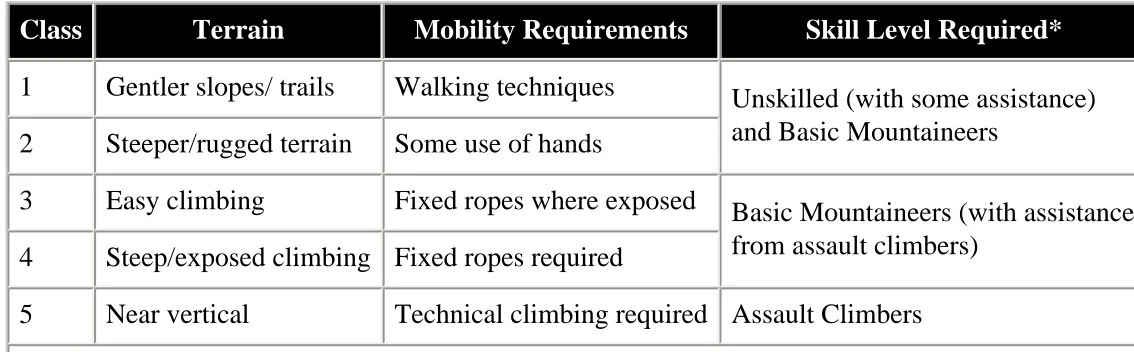
MOUNTAIN CLASSIFICATIONS
1-10. There is no simple system available to classify mountain environments. Soil
composition, surface configuration, elevation, latitude, and climatic patterns determine the specific characteristics of each major mountain range. When alerted to the potential
requirement to conduct mountain operations, commanders must carefully analyze each of these characteristics for the specific mountain region in which their forces will operate. However, mountains are generally classified or described according to their local relief; for military purposes, they may be classified according to operational terrain levels and
dismounted mobility and skill requirements.
1-11. Mountains are commonly classified as low or high, depending on their local relief and, to some extent, elevation. Low mountains have a local relief of 300 to 900 meters (1,000 to 3,000 feet) with summits usually below the timberline. High mountains have a local relief usually exceeding 900 meters (3,000 feet) and are characterized by barren alpine zones above the timberline. Glaciers and perennial snow cover are common in high mountains and usually present commanders with more obstacles and hazards to movement than do low mountains.
Operational Terrain Levels
Level Description
I The bottoms of valleys and main lines of communications
II The ridges, slopes, and passes that overlook valleys
III The dominant terrain of the summit region
Figure 1-2. Operational Terrain Levels
1-12. Mountain operations are generally carried out at three different operational terrain levels (see Figure 1-2). Level I terrain is located at the bottom of valleys and along the main lines of communications. At this level, heavy forces can operate, but maneuver space is often
restricted. Light and heavy forces are normally combined, since
vital lines of communication usually follow the valley highways, roads, and trails.
1-13. Level II terrain lies between valleys and shoulders of mountains. Generally, narrow roads and trails, which serve as secondary lines of communication, cross this ridge system. Ground mobility is difficult and light forces will expend great effort on these ridges, since they can easily influence operations at Level I. Similarly, enemy positions at the next level can threaten operations on these ridges.
1-14. Level III includes the dominant terrain of summit regions. Although summit regions may contain relatively gentle terrain, mobility in Level III is usually the most difficult to achieve and maintain. Level III terrain, however, can provide opportunities for well-trained units to attack the enemy from the flanks and rear. At this terrain level, acclimatized soldiers with advanced mountaineering training can infiltrate to attack lines of communication, logistics bases, air defense sites, and command infrastructures.
Dismounted Mobility Classification
individual movement skill required (see Figure 1-3). Operations conducted in class 1 and 2 terrain require little to no mountaineering skills. Operations in class 3, 4, and 5 terrain require a higher level of mountaineering skills for safe and efficient movement.
Commanders should plan and prepare for mountain operations based, in large part, on this type of terrain analysis.
Class Terrain Mobility Requirements Skill Level Required* 1 Gentler slopes/ trails Walking techniques Unskilled (with some assistance)
and Basic Mountaineers 2 Steeper/rugged terrain Some use of hands
3 Easy climbing Fixed ropes where exposed Basic Mountaineers (with assistance from assault climbers)
4 Steep/exposed climbing Fixed ropes required
[image:15.612.17.584.129.305.2]5 Near vertical Technical climbing required Assault Climbers * See Chapter 2 for a discussion of mountaineering skill levels
Figure 1-3. Dismounted Mobility Classification
WEATHER
1-16. In general, mountain climates tend to be cooler, wetter versions of the climates of the surrounding lowlands. Most mountainous regions exhibit at least two different climatic zones — a zone at low elevations and another at elevations nearer the summit regions. In some areas, an almost endless variety of local climates may exist within a given
mountainous region. Conditions change markedly with elevation, latitude, and exposure to atmospheric winds and air masses. In addition, the climatic patterns of two ranges located at the same latitude may differ radically.
1-17. Like most other landforms, oceans influence mountain climates. Mountain ranges in close proximity to oceans and other large bodies of water usually exhibit a maritime climate. Maritime climates generally produce milder temperatures and much larger amounts of rain and snow. Their relatively mild winters produce heavy snowfalls, while their summer temperatures rarely get excessively hot. Mountains farther inland usually display a more continental climate. Winters in this type climate are often bitterly cold, while summers can be extremely hot. Annual rain- and snowfall here is far less than in a maritime climate and may be quite scarce for long periods. Relatively shallow snow-packs are normal during a continental climate’s winter season.
amounts of rain and snow on the windward side of the range. As air masses pass over mountains, the leeward slopes receive far less precipitation than the windward slopes. It is not uncommon for the climate on the windward side of a mountain range to be humid and the climate on the leeward side arid. This phenomenon affects coastal mountains, as well as mountains farther inland. The deepest winter snow-packs will almost always be found on the windward side of mountain ranges. As a result, vegetation and forest characteristics may be markedly different between these two areas. Prevailing winds and storm patterns
normally determine the severity of these effects.
1-19. Mountain weather can be erratic, varying from strong winds to calm, and from
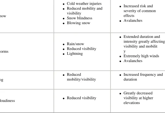
extreme cold to relative warmth within a short time or a minor shift in locality. The severity and variance of the weather require soldiers to be prepared for alternating periods of heat and cold, as well as conditions ranging from dry to extremely wet. At higher elevations, noticeable temperature differences may exist between sunny and shady areas or between areas exposed to wind and those protected from it. This greatly increases every soldier’s clothing load and a unit’s overall logistical requirements. Figure 1-4 summarizes the effects of mountain weather discussed below. FM 2-33.201 and FM 3-97.22 contain additional information on how weather affects operations.
Weather Condition Flat to Moderate Terrain
Effects Added Mountain Effects
Sunshine
● Sunburn
● Snow blindness
● Temperature differences
between sun and shade
● Increased risk of sunburn
and snow blindness
● Severe, unexpected
temperature variations between sun and shade
● Avalanches
Wind ● Windchill
● Increased risk and
severity of windchill
● Blowing debris or driven
snow causing reduced visibility
● Avalanches
Rain
● Reduced visibility ● Cooler temperatures
Snow
● Cold weather injuries ● Reduced mobility and
visibility
● Snow blindness ● Blowing snow
● Increased risk and
severity of common effects
● Avalanches
Storms
● Rain/snow
● Reduced visibility ● Lightning
● Extended duration and
intensity greatly affecting visibility and mobilit y
● Extremely high winds ● Avalanches
Fog
● Reduced
mobility/visibility
● Increased frequency and
duration
Cloudiness ● Reduced visibility
● Greatly decreased
[image:17.612.27.594.28.416.2]visibility at higher elevations
Figure 1-4. Comparison of Weather Effects
TEMPERATURE
1-20. Normally, soldiers encounter a temperature drop of three to five degrees Fahrenheit per 300-meter (1,000-foot) gain in elevation. In an atmosphere containing considerable water vapor, the temperature drops about one degree Fahrenheit for every 100-meter (300-foot) increase. In very dry air, it drops about one degree Fahrenheit for every 50 meters (150 feet). However, on cold, clear, and calm mornings, when a troop movement or climb begins from a valley, soldiers may encounter higher temperatures as they gain elevation. This reversal of the normal situation is called temperature inversion. Additionally, during winter months, the temperature is often higher during a storm than during periods of clear weather. However, the dampness of precipitation and penetration of the wind may still cause soldiers to chill faster. This is compounded by the fact that the cover afforded by vegetation often does not exist above the tree-line. Under these conditions, commanders must weigh the tactical advantage of retaining positions on high ground against seeking shelter and warmth at lower elevations with reduced visibility.
the temperature in the sun and that in the shade. This is similar in magnitude to the day-to-night temperature fluctuations experienced in some deserts (see FM 3-97.3). Besides
permitting rapid heating, the clear air at high altitudes also results in rapid cooling at night. Consequently, temperatures rise swiftly after sunrise and drop quickly after sunset. Much of the chilled air drains downward so that the differences between day and night temperatures are greater in valleys than on slopes.
WIND
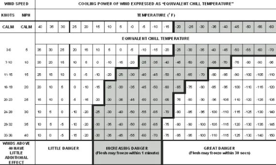
1-22. In high mountains, the ridges and passes are seldom calm. By contrast, strong winds in protected valleys are rare. Normally, wind velocity increases with altitude and is intensified by mountainous terrain. Valley breezes moving up-slope are more common in the morning, while descending mountain breezes are more common in the evening. Wind speed increases when winds are forced over ridges and peaks (orographic lifting), or when they funnel through narrowing mountain valleys, passes, and canyons (Venturi effect). Wind may blow with great force on an exposed mountainside or summit. As wind speed doubles, its force on an object nearly quadruples.
1-23. Mountain winds cause rapid temperature changes and may result in blowing snow, sand, or debris that can impair movement and observation. Commanders should routinely consider the combined cooling effect of ambient temperature and wind (windchill)
Figure 1-5. Windchill Chart
PRECIPITATION
1-24. The rapid rise of air masses over mountains creates distinct local weather patterns. Precipitation in mountains increases with elevation and occurs more often on the windward than on the leeward side of ranges. Maximum cloudiness and precipitation generally occur near 1,800 meters (6,000 feet) elevation in the middle latitudes and at lower levels in the higher latitudes. Usually, a heavily wooded belt marks the zone of maximum precipitation.
Rain and Snow
1-25. Both rain and snow are common in mountainous regions. Rain presents the same challenges as at lower elevations, but snow has a more significant influence on all
operations. Depending on the specific region, snow may occur at anytime during the year at elevations above 1,500 meters (5,000 feet). Heavy snowfall greatly increases avalanche hazards and can force changes to previously selected movement routes. In certain regions, the intensity of snowfall may delay major operations for several months. Dry, flat riverbeds may initially seem to be excellent locations for assembly areas and support activities,
Thunderstorms
1-26. Although thunderstorms are local and usually last only a short time, they can impede mountain operations. Interior ranges with continental climates are more conducive to
thunderstorms than coastal ranges with maritime climates. In alpine zones, driving snow and sudden wind squalls often accompany thunderstorms. Ridges and peaks become focal points for lightning strikes, and the occurrence of lightning is greater in the summer than the
winter. Although statistics do not show lightning to be a major mountaineering hazard, it should not be ignored and soldiers should take normal precautions, such as avoiding summits and ridges, water, and contact with metal objects.
Traveling Storms
1-27. Storms resulting from widespread atmospheric disturbances involve strong winds and heavy precipitation and are the most severe weather condition that occurs in the mountains. If soldiers encounter a traveling storm in alpine zones during winter, they should expect low temperatures, high winds, and blinding snow. These conditions may last several days longer than in the lowlands. Specific conditions vary depending on the path of the storm. However, when colder weather moves in, clearing at high elevations is usually slow.
Fog
1-28. The effects of fog in mountains are much the same as in other terrain. However,
because of the topography, fog occurs more frequently in the mountains. The high incidence of fog makes it a significant planning consideration as it restricts visibility and observation complicating reconnaissance and surveillance. However, fog may help facilitate covert operations such as infiltration. Routes in areas with a high occurrence of fog may need to be marked and charted to facilitate passage.
SECTION II — EFFECTS ON PERSONNEL
1-29. The mountain environment is complex and unforgiving of errors. Soldiers conducting operations anywhere, even under the best conditions, become cold, thirsty, tired, and energy-depleted. In the mountains however, they may become paralyzed by cold and thirst and incapacitated due to utter exhaustion. Conditions such as high elevations, rough terrain, and extremely unpredictable weather require leaders and soldiers who have a keen
understanding of environmental threats and what to do about them.
Figure 1-6. Environmental and Soldier Conditions Influencing Mountain Injuries and Illnesses
one illness or injury at a time, increasing the danger to life and limb. Three of the most common, cumulative, and subtle factors affecting soldier ability under these variable conditions are nutrition (to include water
intake), decreased oxygen due to high altitude, and cold. Preventive measures, early recognition, and rapid treatment help minimize nonbattle casualties due to these conditions (see
Appendix A for detailed information on
mountain-specific illnesses and injuries).
NUTRITION
1-31. Poor nutrition contributes to illness or injury, decreased performance, poor morale, and susceptibility to cold injuries, and can severely affect military operations. Influences at high altitudes that can affect nutrition include a dulled taste sensation (making food
undesirable), nausea, and lack of energy or motivation to prepare or eat meals.
1-32. Caloric requirements increase in the mountains due to both the altitude and the cold. A diet high in fat and carbohydrates is important in helping the body fight the effects of these conditions. Fats provide long-term, slow caloric release, but are often unpalatable to soldiers operating at higher altitudes. Snacking on high-carbohydrate foods is often the best way to maintain the calories necessary to function.
1-33. Products that can seriously impact soldier performance in mountain operations include:
● Tobacco. Tobacco smoke interferes with oxygen delivery by reducing the blood’s
effectively raise the "physiological altitude" as much as several hundred meters.
● Alcohol. Alcohol impairs judgement and perception, depresses respiration, causes
dehydration, and increases susceptibility to cold injury.
● Caffeine. Caffeine may improve physical and mental performance, but it also causes
increased urination (leading to dehydration) and, therefore, should be consumed in moderation.
1-34. Significant body water is lost at higher elevations from rapid breathing, perspiration, and urination. Depending upon level of exertion, each soldier should consume about four to eight quarts of water or other decaffeinated fluids per day in low mountains and may need ten quarts or more per day in high mountains. Thirst is not a good indicator of the amount of water lost, and in cold climates sweat, normally an indicator of loss of fluid, goes unnoticed. Sweat evaporates so rapidly or is absorbed so thoroughly by clothing layers that it is not readily apparent. When soldiers become thirsty, they are already dehydrated. Loss of body water also plays a major role in causing altitude sickness and cold injury. Forced drinking in the absence of thirst, monitoring the deepness of the yellow hue in the urine, and watching for behavioral symptoms common to altitude sickness are important factors for commanders to consider in assessing the water balance of soldiers operating in the
mountains.
1-35. In the mountains, as elsewhere, refilling each soldier's water containers as often as possible is mandatory. No matter how pure and clean mountain water may appear, water from natural sources should always be purified or chemically sterilized to prevent parasitical illnesses (giardiasis). Commanders should consider requiring the increased use of individual packages of powdered drink mixes, fruit, and juices to help encourage the required fluid intake.
ALTITUDE
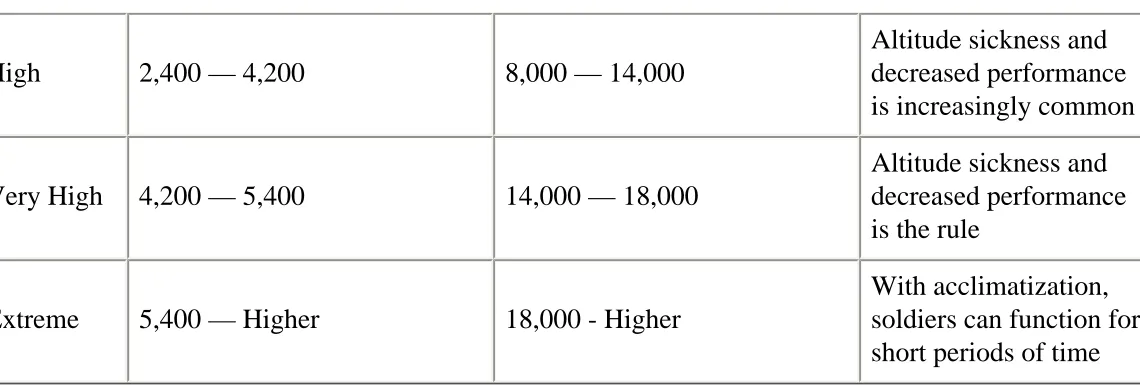
1-36. As soldiers ascend in altitude, the proportion of oxygen in the air decreases. Without proper acclimatization, this decrease in oxygen saturation can cause altitude sickness and reduced physical and mental performance (see Figure 1-7). Soldiers cannot maintain the same physical performance at high altitude that they can at low altitude, regardless of their fitness level.
Altitude Meters Feet Effects
Low Sea Level — 1,500 Sea Level — 5,000 None.
High 2,400 — 4,200 8,000 — 14,000
Altitude sickness and decreased performance is increasingly common
Very High 4,200 — 5,400 14,000 — 18,000
Altitude sickness and decreased performance is the rule
Extreme 5,400 — Higher 18,000 - Higher
[image:23.612.24.594.20.214.2]With acclimatization, soldiers can function for short periods of time
Figure 1-7. Effects of Altitude
1-37. The mental effects most noticeable at high altitudes include decreased perception, memory, judgement, and attention. Exposure to altitudes of over 3,000 meters (10,000 feet) may also result in changes in senses, mood, and personality. Within hours of ascent, many soldiers may experience euphoria, joy, and excitement that are likely to be accompanied by errors in judgement, leading to mistakes and accidents. After a period of about 6 to 12 hours, euphoria decreases, often changing to varying degrees of depression. Soldiers may become irritable or may appear listless. Using the buddy system during this early exposure helps to identify soldiers who may be more severely affected. High morale and esprit instilled before deployment and reinforced frequently help to minimize the impact of negative mood
changes.
1-38. The physical effect most noticeable at high altitudes includes vision. Vision is generally the sense most affected by altitude exposure and can potentially affect military operations at higher elevations. Night vision is significantly reduced, affecting soldiers at approximately 2,400 meters (8,000 feet) or higher. Some effects occur early and are
temporary, while others may persist after acclimatization or even for a period of time after descent. To compensate for loss of functional abilities, commanders should make use of tactics, techniques, and procedures that trade speed for increased accuracy. By allowing extra time to accomplish tasks, commanders can minimize errors and injuries.
HYPOXIA-RELATED ILLNESSES AND EFFECTS
1-39. Hypoxia, a deficiency of oxygen reaching the tissues of the body, has been the cause of many mountain illnesses, injuries, and deaths. It affects everyone, but some soldiers are more vulnerable than others. A soldier may be affected at one time but not at another. Altitude hypoxia is a killer, but it seldom strikes alone. The combination of improper
● Acute Mountain Sickness (AMS). Headache, nausea, vomiting, fatigue, irritability,
and dizziness.
● High Altitude Pulmonary Edema (HAPE). Coughing, noisy breathing, wheezing,
gurgling in the airway, difficulty breathing, and pink frothy sputum (saliva). Ultimately coma and death will occur without treatment.
● High Altitude Cerebral Edema (HACE). HACE is the most severe illness associated
with high altitudes. Its symptoms often resemble AMS (severe headache, nausea, vomiting), often with more dramatic signals such as a swaying of the upper body, especially when walking, and an increasingly deteriorating mental status. Early mental symptoms may include confusion, disorientation, vivid hallucinations, and drowsiness. Soldiers may appear to be withdrawn or demonstrate behavior generally associated with fatigue or anxiety. Like HAPE, coma or death will occur without treatment.
OTHER MOUNTAIN-RELATED ILLNESSES
1-40. Other illnesses and effects related to the mountain environment and higher elevations are:
● Subacute mountain sickness. Subacute mountain sickness occurs in some soldiers
during prolonged deployments (weeks/months) to elevations above 3,600 meters (12,000 feet). Symptoms include sleep disturbance, loss of appetite, weight loss, and fatigue. This condition reflects a failure to acclimatize adequately.
● Carbon monoxide poisoning. Carbon monoxide poisoning is caused by the inefficient
fuel combustion resulting from the low oxygen content of air and higher usage of stoves, combustion heaters, and engines in enclosed, poorly ventilated spaces.
● Sleep disturbances. High altitude has significant harmful effects on sleep. The most
prominent effects are frequent periods of apnea (temporary suspension of respiration) and fragmented sleep. Sleep disturbances may last for weeks at elevations less than 5,400 meters (18,000 feet) and may never stop at higher elevations. These effects have even been reported as low as 1,500 meters (5,000 feet).
● Poor wound healing. Poor wound healing resulting from lowered immune functions
may occur at higher elevations. Injuries resulting from burns, cuts, or other sources may require descent for effective treatment and healing.
ACCLIMATIZATION
altitude illnesses from occurring if ascent to higher altitudes is too rapid.
● Altitude
● Rate of Ascent ● Duration of Stay ● Level of Exertion
Figure 1-8. Factors Affecting Acclimatization
1-42. Getting used to living and working at higher altitudes requires acclimatization. Figure 1-8 shows the four factors that affect acclimatization in mountainous terrain. These factors are similar to those a scuba diver must consider, and the consequences of an error can be just as severe. In particular, high altitude climbing must be carefully paced and staged in the same way that divers must pace and stage their ascent to the surface.
1-43. For most soldiers at high to very high altitudes,
70 to 80 percent of the respiratory component of acclimatization occurs in 7 to 10 days, 80 to 90 percent of overall acclimatization is generally accomplished by 21 to 30 days, and maximum acclimatization may take several months to years. However, some soldiers may acclimatize more rapidly than others, and a few soldiers may not acclimatize at all. There is no absolute way to identify soldiers who cannot acclimatize, except by their experience during previous altitude exposures.
1-44. Commanders must be aware that highly fit, motivated individuals may go too high too fast and become victims of AMS, HAPE, or HACE. Slow and easy climbing, limited
activity, and long rest periods are critical to altitude acclimatization. Leaves that involve soldiers descending to lower altitudes and then returning should be limited. Acclimatization may be accomplished by either a staged or graded ascent. A combination of the two is the safest and most effective method for prevention of high altitude illnesses.
● Staged Ascent. A staged ascent requires soldiers to ascend to a moderate altitude and
remain there for 3 days or more to acclimatize before ascending higher (the longer the duration, the more effective and thorough the acclimatization to that altitude). When possible, soldiers should make several stops for staging during ascent to allow a greater degree of acclimatization.
● Graded Ascent. A graded ascent limits the daily altitude gain to allow partial
acclimatization. The altitude at which soldiers sleep is the critical element in this regard. Having soldiers spend two nights at 2,700 meters (9,000 feet) and limiting the sleeping altitude to no more than 300 meters per day (1,000 feet) above the previous night’s sleeping altitude will significantly reduce the incidence of altitude sickness.
1-45. In situations where there is insufficient time for a staged or graded ascent,
wilderness medicine concerning doses, side effects, and screening of individuals who may be allergic. As a non-pharmacological method, high carbohydrate diets (whole grains,
vegetables, peas and beans, potatoes, fruits, honey, and refined sugar) are effective in aiding acclimatization.
COLD
● Frostbite (freezing) ● Hypothermia
(nonfreezing)
● Trench/immersion Foot
(nonfreezing)
● Snow Blindness
Figure 1-9. Common Cold Weather Injuries
1-46. After illnesses related to not being acclimatized, cold injuries, both freezing and nonfreezing, are generally the greatest threat.
Temperature and humidity decrease with increasing altitude. Reviewing cold weather injury prevention, training in shelter construction, dressing in layers, and using the buddy system are critical and may preclude large numbers of debilitating injuries.
Figure 1-9 lists the cold and snow injuries most common to mountain operations. See FM 3-97.11
andFM 4-25.11 for information regarding causes, symptoms, treatment, and prevention.
1-47. Altitude sickness and cold injuries can occur simultaneously, with signs and symptoms being confused with each other. Coughing, stumbling individuals should be immediately evacuated to medical support at lower levels to determine their medical condition. Likewise, soldiers in extreme pain from cold injuries who do not respond to normal pain medications, require evacuation. Without constant vigilance, cold injuries may significantly limit the number of deployable troops and drastically reduce combat power. However, with command emphasis and proper equipment, clothing, and training, all cold-weather injuries are preventable.
SECTION III — EFFECTS ON EQUIPMENT
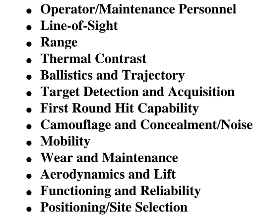
1-48. No manual can cover the effects of terrain and weather on every weapon and item of equipment within the Army inventory. Although not all-encompassing, the list at Figure 1-10 contains factors that commanders should take into account when considering the effect the mountainous environment may have on their weapons and equipment. Of these, the most important factor is the combined effects of the environment on the soldier and his
● Operator/Maintenance Personnel ● Line-of-Sight
● Range
● Thermal Contrast
● Ballistics and Trajectory
● Target Detection and Acquisition ● First Round Hit Capability
● Camouflage and Concealment/Noise ● Mobility
[image:27.612.300.561.43.264.2]● Wear and Maintenance ● Aerodynamics and Lift ● Functioning and Reliability ● Positioning/Site Selection
Figure 1-10. Weapons and Equipment Factors Affected by the Environment
techniques, and procedures to win on the mountain battlefield.
GENERAL EFFECTS
1-49. In a mountainous environment, the speed and occurrence of wind generally increase with elevation, and the effects of wind increase with range (depending on the speed and direction). Due to these factors, soldiers must be taught the effects of wind on ballistics and how to compensate for them. In cold weather, firing weapons often creates ice fog trails. These ice fog trails obscure vision and, at the same time, allow the enemy
to more easily discern the location of primary positions and the overall structure of a unit’s defense. This situation increases the importance of alternate and supplementary firing positions.
1-50. Range estimation in mountainous terrain is difficult. Depending upon the type of terrain in the mountains, soldiers may either over- or underestimate range. Soldiers
observing over smooth terrain, such as sand, water, or snow, generally underestimate ranges. This results in attempting to engage targets beyond the maximum effective ranges of their weapon systems. Looking downhill, targets appear to be farther away and looking uphill, they appear to be closer. This illusion, combined with the effects of gravity, causes the soldier shooting downhill to fire high, while it has the opposite effect on soldiers shooting uphill.
1-51. Higher elevations generally afford increased observation but low-hanging clouds and fog may decrease visibility, and the rugged nature of mountain terrain may produce
significant dead space at mid-ranges. These effects mean that more observation posts are necessary to cover a given frontage in mountainous terrain than in non-mountainous terrain. They also require the routine designation of supplementary firing positions for direct fire weapons. Rugged terrain also makes ammunition resupply more difficult and increases the need to enforce strict fire control and discipline. Finally, the rugged environment creates compartmented areas that may preclude mutual support and reduce supporting distances.
1-52. In rocky mountainous terrain, the effectiveness of small arms fire increases by the splintering and ricocheting when a bullet strikes a rock. M203 and MK-19 grenade
launchers are useful for covering close-in dead space in mountainous terrain. Hand grenades are also effective. Although it may seem intuitive, soldiers must still be cautioned against throwing grenades uphill where they are likely to roll back before detonation. Grenades (as well as other explosive munitions) lose much of their effectiveness when detonated under snow, and soldiers should be warned that hand grenades may freeze to wet gloves.
1-53. As elevation increases, air pressure and air density decrease. At higher elevations, a round is more efficient and strikes a target higher, due to reduced drag. This effect does not significantly influence the marksmanship performance of most soldiers, however,
designated marksmen and snipers should re-zero their weapons after ascending to higher elevations. (See FM 3-25.9 and FM 3-23.10 for further information on ballistics and weather effects on small arms.)
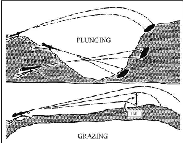
[image:28.612.283.589.339.578.2]MACHINE GUNS
Figure 1-11. Classes of Fire with Respect to the Ground
1-54. Machine guns provide long-range fire when visibility is good. However, grazing fire can rarely be achieved in mountains because of the radical changes in elevation. When grazing fire can be obtained, the ranges are normally short. More often, plunging fire is the result (see
Figure 1-11 and FM 3-21.7). In mountainous terrain, situations that prevent indirect fire support from protecting advancing forces may arise. When these occur, the effects of machine-guns and other direct fire weapons must be concentrated to provide adequate supporting fires for maneuvering elements.
Again, supplementary positions should be routinely prepared to cover different avenues of approach and dead space.
1-55. The AT4 is a lightweight antitank weapon ideally suited for the mountainous environment and for direct fire against enemy weapon emplacements. Anti-tank guided missiles (ATGMs), such as the Javelin and the tube-launched, optically tracked, wire-guided, heavy antitank missile system (TOW), tend to hinder dismounted operations because of their bulk and weight. In very restrictive mountainous terrain, the lack of armored avenues of approach and suitable targets may limit their utility. If an armored or mechanized threat is present, TOWs are best used in long-range, antiarmor ambushes, while the shorter-range Javelin, with its fire-and-forget technology, is best used from restrictive terrain nearer the kill zone. However, their guidance systems may operate stiffly and sluggishly in extreme cold weather.
SECTION IV — RECONNAISSANCE AND SURVEILLANCE
RECONNAISSANCE
1-56. During operations in a mountainous environment, reconnaissance is as applicable to the maneuver of armies and corps as it is to tactical operations. Limited routes, adverse terrain, and rapidly changing weather significantly increase the importance of
reconnaissance operations to focus fires and maneuver. Failure to conduct effective reconnaissance will result in units being asked to achieve the impossible or in missed opportunities for decisive action.
1-57. As in all environments, reconnaissance operations in a mountainous area must be layered and complementary in order to overcome enemy attempts to deny critical
information to the friendly commander. In order to gather critical and timely information required by the commander, the activities of reconnaissance assets must be closely
coordinated. Strategic reconnaissance platforms set the stage by identifying key terrain, as well as the general disposition and composition of enemy forces. Operational level
commanders compare the information provided by strategic assets with their own requirements and employ reconnaissance assets to fill in the gaps that have not been answered by strategic systems and achieve the level of detail they require.
1-58. At the beginning of a campaign in a mountainous environment, reconnaissance requirements will be answered by aerial or overhead platforms, such as satellites, joint surveillance, target attack radar systems (JSTARSs), U2 aircraft, and unmanned aerial vehicles (UAVs). In a mountain AO, it may often be necessary to commit ground reconnaissance assets in support of strategic and operational information requirements. Conversely, strategic and operational reconnaissance systems may be employed to identify or confirm the feasibility of employing ground reconnaissance assets. Special
insertion for the team. The potential hide positions for the teams are identified using imagery and, terrain and weather permitting, verified by UAVs. See FM 3-100.55 for detailed information on combined arms reconnaissance.
1-59. In harsh mountain terrain, ground reconnaissance operations are often conducted dismounted. Commanders must assess the slower rate of ground reconnaissance elements to determine its impact on the entire reconnaissance and collection process. They must develop plans that account for this slower rate and initiate reconnaissance as early as possible to provide additional time for movement. Commanders may also need to allocate more forces, including combat forces, to conduct reconnaissance, reconnaissance in force missions, or limited objective attacks to gain needed intelligence. Based upon mission, enemy, terrain and weather, troops and support available, time available, civil considerations (METT-TC), commanders may need to prioritize collection assets, accept risk, and continue with less information from their initial reconnaissance efforts. In these cases, they must use formations and schemes of maneuver that provide maximum security and flexibility, to include robust security formations, and allow for the development of the situation once in contact.
1-60. Although reconnaissance patrols should normally use the heights to observe the
enemy, it may be necessary to send small reconnaissance teams into valleys or along the low ground to gain suitable vantage points or physically examine routes that will be used by mechanized or motorized forces. In mountainous environments, reconnaissance elements are often tasked to determine:
● The enemy's primary and alternate lines of communication.
● Locations and directions from which the enemy can attack or counterattack. ● Heights that allow the enemy to observe the various sectors of terrain. ● Suitable observation posts for forward observers.
● Portions of the route that provide covert movement.
● Level of mountaineering skill required to negotiate routes (dismounted mobility
classification) and sections of the route that require mountaineering installations.
● Suitability of routes for sustained combat service support (CSS) operations.
● Trails, routes, and bridges that can support or can be improved by engineers in order
to move mechanized elements into areas previously thought to be impassable.
● Bypass routes.
● Potential airborne and air assault drop/pick-up zones and aircraft landing areas.
RECONNAISSANCE IN FORCE
enemy situation at selected points. Commanders should carefully consider mobility
restrictions that may affect plans for withdrawal or exploitation. Commanders should also position small reconnaissance elements or employ surveillance systems throughout the threat area of operations to gauge the enemy’s reaction to friendly reconnaissance in force operations and alert the force to possible enemy counterattacks. In the mountains, the risk of having at least a portion of the force cut off and isolated is extremely high. Mobile reserves and preplanned fires must be available to reduce the risk, decrease the vulnerability of the force, and exploit any success as it develops.
ENGINEER RECONNAISSANCE
1-62. Engineer reconnaissance assumes greater significance in a mountainous environment in order to ensure supporting engineers are properly task organized with specialized
equipment for quickly overcoming natural and reinforcing obstacles. Engineer
reconnaissance teams assess the resources required for clearing obstacles on precipitous slopes, constructing crossing sites at fast-moving streams and rivers, improving and repairing roads, erecting fortifications, and establishing barriers during the conduct of defensive operations. Since the restrictive terrain promotes the widespread employment of point obstacles, engineer elements should be integrated into all mountain reconnaissance operations.
1-63. In some regions, maps may be unsuitable for tactical planning due to inaccuracies, limited detail, and inadequate coverage. In these areas, engineer reconnaissance should precede, but not delay operations. Because rugged mountain terrain makes ground reconnaissance time-consuming and dangerous, a combination of ground and aerial or overhead platforms should be used for the engineer reconnaissance effort. Data on the terrain, vegetation, and soil composition, combined with aerial photographs and
multispectral imagery, allows engineer terrain intelligence teams to provide detailed information that may be unavailable from other sources.
AERIAL AND OVERHEAD RECONNAISSANCE
1-65. Terrain may significantly impact the employment of overhead reconnaissance platforms using radar systems to detect manmade objects. These systems may find
themselves adversely impacted by the masking effect that occurs when the mountain terrain blocks the radar beam. Thus, the radar coverage may not extend across the reverse slope of a steep ridge or a valley floor. Attempts to reposition the overhead platform to a point where it can "see" the masked area may merely result in masking occurring elsewhere. This
limitation does not preclude using such systems; however, the commander should employ manned or unmanned aerial reconnaissance when available, in conjunction with overhead reconnaissance platforms in order to minimize these occurrences. The subsequent use of ground reconnaissance assets to verify the data that can be gathered by overhead and electro-optical platforms will ensure that commanders do not fall prey to deliberate enemy
deception efforts that capitalize on the limited capabilities of some types of overhead platforms in this environment.
SURVEILLANCE
1-66. In the mountains, surveillance of vulnerable flanks and gaps between units is accomplished primarily through well-positioned observation posts (OPs). These OPs are normally inserted by helicopter and manned by small elements equipped with sensors, enhanced electro-optical devices, and appropriate communications. Commanders must develop adequate plans that address not only their insertion, but their continued support and ultimate extraction. The considerations of METT-TC may dictate that commanders provide more personnel and assets than other types of terrain to adequately conduct surveillance missions. Commanders must also ensure that surveillance operations are fully integrated with reconnaissance efforts in order to provide a3dequate coverage of the AO.
RDL Homepage
Table of Contents
Document Information
Download Instructions
Chapter 2
Command and Control
Contents
Section I — Assessment of the Situation Mission
Enemy
Terrain and Weather
Troops and Support Available Time Available
Civil Considerations Section II — Leadership
Section III — Communications Combat Net Radio
Mobile Subscriber Equipment Wire and Field Phones
Audio, Visual, and Physical Signals
In the mountains, major axes of advance are limited to accessible valleys and often separated by restrictive terrain. The compartmented nature of the terrain makes it difficult to switch the effort from one axis to another or to offer mutual support between axes. The battle to control the major lines of communications of Level I develops on the ridges and heights of Level II. In turn, the occupation of the
dominating heights in Level II may leave a force assailable from the restrictive terrain of Level III. Each operational terrain level influences the application of tactics, techniques, and
procedures necessary for successful operations.
Messenger
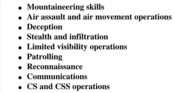
Section IV — Training
Initial Training Assessment Physical Conditioning Mountain Living Navigation
Weapons and Equipment Camouflage and Concealment Fortifications
Military Mountaineering Driver Training
Army Aviation
Reconnaissance and Surveillance Team Development
elements extremely long, and mutual support difficult to accomplish. Command and control of all available assets is best achieved if
command posts are well forward. However, the mountainous environment decreases the
commander’s mobility. Therefore, commanders must be able to develop a clear vision of how the battle will unfold, correctly anticipate the decisive points on the battlefield, and position themselves at these critical points.
The success of a unit conducting mountain operations depends on how well leaders control their units. Control is limited largely to a well-thought-out plan and thorough preparation. Boundaries require careful planning in mountain operations. Heights overlooking valleys should
be included in the boundaries of units capable of exerting the most influence over them. These boundaries may be difficult to determine initially and may require subsequent adjustment.
During execution, leaders must be able to control direction and speed of movement, maintain proper intervals, and rapidly start, stop, or shift fire. In the mountains, soldiers focus mainly on negotiating
difficult terrain. Leaders, however, must ensure that their soldiers remain alert for, understand, and follow signals and orders. Although in most instances audio, visual, wire, physical signals, and messengers are used to maintain control, operations may be controlled by time as a secondary means. However, realistic timetables must be based on thorough reconnaissance and sound practical knowledge of the mountain battlefield.
Commanders must devote careful consideration to the substantial effect the mountain environment may have on systems that affect their ability to collect, process, store, and disseminate information. Computers, communications, and other sophisticated electronic equipment are usually susceptible to jars, shocks, and rough handling associated with the rugged mountain environment. They are also extremely sensitive to the severe cold often associated with higher elevations. Increased precipitation and moisture may damage electronic components, and heavy amounts of rain and snow, combined with strong surface winds, may generate background electronic interference that can reduce the efficiency of intercept/direction finding antennas and ground surveillance radars. Localized storms with low sustained cloud cover reduce the effectiveness of most imagery intelligence (IMINT) platforms, to include unmanned aerial vehicles (UAVs). The collective effect of mountain weather and terrain diminishes a commander’s ability to achieve shared situational understanding among his subordinates. However, increased use of human intelligence (HUMINT), clear orders and intents, and leaders capable of exercising initiative, allow commanders to dominate the harsh environment of a mountain area of operations.
units do not routinely train for or operate in the mountains, the level of uncertainty, ambiguity, and friction is often higher than in less rugged environments. Commanders must be able to identify and assess hazards that may be encountered in executing their missions, develop and implement control measures to eliminate unnecessary risk, and continuously supervise and assess to ensure measures are properly executed and remain appropriate as the situation changes. Although risk decisions are the commanders’ business, staffs, subordinate leaders, and individual soldiers must also understand the risk management process and must continuously look for hazards at their level or within their area of expertise. Any risks identified (with recommended risk reduction measures) must be quickly elevated to the chain of command (see FM 3-100.14).
SECTION I — ASSESSMENT OF THE SITUATION
2-1. Although higher-elevation terrain is not always key, the structure of a mountain area of operations (AO) often forms a stairway of key terrain features. Identification and control of dominant terrain at each operational terrain level form the basis for successful mountain maneuver. Key terrain features at higher elevations often take on added significance due to their inaccessibility and ease of defense. To maintain freedom of maneuver, commanders must apply combat power so that the terrain at Levels II and III can be exploited in the conduct of operations. Successful application of this concept requires commanders to think, plan, and maneuver vertically as well as horizontally.
2-2. Mountain operations usually focus on lines of communication, choke points, and dominating heights. Maneuver generally attempts to avoid strengths, envelop the enemy, and limit his ability to effectively use the high ground. Major difficulties are establishing boundaries, establishing and maintaining communications, providing logistics, and
evacuating wounded. Throughout the plan, prepare, and execute cycle, commanders must continuously assess the vertical impact on the mission, enemy, terrain and weather, troops and support available, time available, civil considerations (METT-TC).
On 25 April 1915, the Allies launched their Gallipoli campaign. However, LTC Mustafa Kemal's
understanding of the decisive importance of the hilly terrain, his grasp of the enemy's overall intent, and his own resolute leadership preserved the Ottoman defenses. His troops seized the initiative from
superior forces and pushed the Allied invasion force back to its bridgehead. The result was nine months of trench warfare, followed by the Allies' withdrawal from Gallipoli.
German Fifth Army Commander General von Sanders expected a major Allied landing in the north, at Bulair. The British, however, were conducting a feint there; two ANZAC divisions were already landing in the south at Ari Burnu (now known as "ANZAC cove") as the main effort. The landing beaches here were hemmed by precipitous cliffs culminating in the high ground of the Sari Bair ridge, a fact of great importance to the defense. Only one Ottoman infantry company was guarding the area. Although prewar plans had established contingencies for using 19th ID, Kemal, the division commander, had received no
word from his superiors regarding the developing scenario. Nevertheless, understanding that a major Allied landing could easily split the peninsula, he decided that time was critical and set off for Ari Burnu without waiting for his senior commander's approval. In his march toward Ari Burnu that morning, he recognized that the hilly terrain in general and the Sari Bair ridge in particular were of vital strategic importance: if the enemy captured this high ground they would be in an excellent position to cut the peninsula in half.
Kemal now engaged the enemy. He impressed upon his men the importance of controlling the hilltops at all costs, issuing his famous order: "I am not ordering you to attack. I am ordering you to die. In the time it takes us to die, other forces and commanders can come and take our place." Despite being
outnumbered three-to-one, the Turkish counterattack stabilized their position and prevented the Allies from capturing the Sari Bair ridge. Nightfall brought about a lull in the fighting. There was some sniping and a few local encounters on 26 April, and on 27 April Kemal finally received major reinforcements. The front stabilized and the opposing armies settled down into trench warfare. On 16 January 1926, the Allies admitted defeat and withdrew.
The 19th ID's counterattack, which prevented the ANZAC from establishing themselves on the Sari Bair
ridge, may well have decided the outcome of the entire Gallipoli campaign. Despite his lack of situational knowledge, Kemal instinctively understood the enemy's intent and, recognizing the
importance of controlling the hilltops and ridgelines, was committed to concentrating his combat power to seize and hold this key terrain.
Compiled from "The Rock of Gallipoli," Studies of Battle Command, George W. Gawrych
MISSION
2-3. Mission analysis must include the spatial and vertical characteristics of the AO.
Therefore, it is imperative to identify the tasks and assets necessary to access each operational terrain level.
2-4. At any operational terrain level, defending and delaying are easier at defiles, while attacking is more difficult. Due to the compartmented terrain, units usually execute
offensive missions by conducting several simultaneous smaller-scale attacks, utilizing the full height, width, and depth of their area of operations. Consequently, commanders must always consider the impact of decentralization on security.
2-5. One method of maintaining freedom of action is to seize or hold key terrain. In the mountains, key terrain is frequently identified as terrain that is higher than that held by the enemy. Seizing this terrain often depends on long and difficult envelopments or turning movements. Therefore, the specified and implied tasks associated with mobility and
sustainment, as well as command and control, must be considered in terms of their vertical difficulty.
ENEMY
● Utilize the environment to his advantage ● Conduct air operations
● Conduct decentralized operations ● Utilize the terrain in Levels II and III ● Employ obstacles or barriers to restrict
maneuverability
● Conduct limited-visibility operations ● Sustain his maneuver elements
Figure 2-1. Factors Affecting Assessment of the Enemy Situation
2-6. An enemy will normally position forces in depth and height along likely avenues of approach. Mountain terrain facilitates wide dispersal,
allowing relatively small units to hold dominant terrain in a
connected system of strong points. To prevent bypassing and envelopment attempts, the enemy may adopt a many-tiered,
perimeter defense. Aside from the relative size of forces, the type of enemy units and their equipment
must be compared with those of friendly forces, to include a comparison of the suitability of forces, tactics, and training. When considering the enemy's ability to operate in mountainous terrain, commanders should consider how well the enemy can accomplish the tasks and actions listed in Figure 2-1. Again, in analyzing both enemy and friendly factors during mountain operations, the vertical, as well as the horizontal, perspective should be fully integrated into all aspects of the assessment.
TERRAIN AND WEATHER
cover and concealment, obstacles, key terrain, and avenues of approach (OCOKA). Terrain often influences the conduct of operations more in the mountains than on flatter terrain. The mountains form the nonlinear and vertical structure of the battlefield, and the influences of geography and climate dictate the extent to which commanders modify tactics. Examples of these difficulties are often encountered in the concentration of forces, as well as in the maintenance of command and control.
2-8. In the mountains, as elsewhere, surprise is easier to achieve for the force that knows the terrain better and has the skills and equipment necessary to achieve greater mobility. The appropriate use of vertical terrain improves the element of surprise if the terrain has been analyzed properly to determine the best means to counter the enemy’s reactions. Once the commander decides on a preliminary course of action, he should immediately initiate a detailed terrain reconnaissance.
2-9. In a mountainous environment, the terrain normally favors the defender and
necessitates the conduct of limited visibility operations. Highly trained units can achieve significant tactical gains and decisive victories by exploiting limited visibility. However, limited visibility operations in mountainous terrain require precise planning, careful daylight reconnaissance, exceptionally good command and control, and a high degree of training. Imaginative and bold limited visibility operations can minimize the advantage of terrain for the defender and shift the balance of combat power to the side that can best cope with or exploit limited visibility.
OBSERVATION AND FIELDS OF FIRE
1. The ability to observe and identify
targets in conditions of bright sunlight
2. The ability to estimate range in clear air 3. The ability to apply wind corrections 4. The ability to shoot accurately up and
down vertical slopes
Figure 2-2. Factors Affecting Observation and Fields of Fire
2-10. Although mountainous terrain generally permits excellent long-range observation and fields of fire, steep slopes and rugged terrain affect a soldier’s ability to accurately estimate range and frequently cause large areas to be hidden from observation. The existence of sharp relief and dead space facilitates covert
approaches, making surveillance difficult despite such long-range
observation. Four factors that influence what can be seen and hit in mountainous terrain are listed in Figure 2-2.
COVER AND CONCEALMENT
mountainous terrain are fundamental to all aspects of mountain operations. The ridge systems found in Level II may provide covert approaches through many areas that are hidden from observation by the vegetation and relief. The difficulties a force encounters in finding available cover and concealment along ridges are fewer than those on the peaks, especially above the timberline. Uncovered portions of an approach leave a force exposed to observation and fire for long periods. The enemy can easily detect movement in this region, leaving commanders with three primary options to improve cover and concealment:
1. Identify and exploit avenues of approach the enemy would consider unlikely, due to their difficult ascent or descent.
2. Negotiate routes during periods of limited visibility. 3. Provide overwhelming route security.
OBSTACLES
2-12. Obvious natural obstacles include deep defiles, cliffs, rivers, landslides, avalanches, crevices, and scree slopes, as well as the physical terrain of the mountains themselves. Obstacles vary in their effect on different forces. Commanders must evaluate the terrain from both the enemy and friendly force perspective. They must look specifically at the degree to which obstacles restrict operations, and at the ability of each force to exploit the tactical opportunities that exist when obstacles are employed. Man-made obstacles used in conjunction with restrictive terrain are extremely effective in the mountains; however, their construction is very costly in terms of time, materiel, transportation assets, and labor.
Commanders must know the location, extent, and strength of obstacles so that they can be incorporated into their scheme of maneuver.
KEY TERRAIN
2-13. Key terrain generally increases in importance with an increase in elevation and a decrease in accessibility. In the mountains, however, terrain that is higher than that held by the opposing force is often key, but only if the force is capable of fighting there. A well-prepared force capable of maneuver in rugged terrain can gain an even greater advantage over an ill-prepared enemy at higher elevation levels.
2-14. The vast majority of operations in the mountains requires that the commander
designate decisive terrain in his concept of operations to communicate its importance to his staff and subordinate commanders. In operations over mountainous terrain, the analysis of key and decisive terrain is based on the identification of these features at each of the three operational terrain levels. There are few truly impassable areas in the mountains. The
commander must recognize that what may be key terrain to one force may be an obstacle to another force. He must also recognize that properly trained combatants can use high
AVENUES OF APPROACH
● Ability to achieve surprise ● Vulnerability to attack from
surrounding heights
● Ability to provide mutual support to
forces on other avenues of approach
● Effect on rates of advance
● Effect on command and control ● Potential to accommodate deception
operations
● Ability to support necessary CS and CSS
operations
● Access to secure rest and halt sites
● Potential to fix the enemy and reduce the
possibility of retreat
Figure 2-3. Factors Affecting Analysis of Avenues of Approach
2-15. In mountainous terrain, there are few easily accessible avenues of approach, and they usually run along valleys, defiles, or the crests and spurs of ridges. This type of geography allows the defender to economize in difficult terrain and to concentrate on dangerous avenues of approach. A typical offensive tactic is to conduct a coordinated assault with the main effort along accessible avenues of approach, and supporting efforts by one or more maneuver elements on difficult and unexpected avenues of approach. Normally, high rates of advance and heavy
concentration of forces are
difficult or impossible to achieve
along mountainous avenues of approach. Relief features may create large areas of dead space that facilitate covert movement. Units may use difficult and unlikely avenues of approach to achieve surprise; however, these are extremely high-risk operations and are prone to f