Article
Cities, from information to interaction
Vinicius M. Netto1,†,‡, Edgardo Brigatti2,‡, João Meirelles3,*, Fabiano L. Ribeiro4,*, Bruno Pace
5,*, Caio Cacholas6,*, Patricia Sanches7,*
1 Department of Urbanism, Universidade Federal Fluminense, Rua Passo da Patria 156, Niteroi, Rio de
Janeiro state, Brazil
2 Institute of Physics, Universidade Federal do Rio de Janeiro (UFRJ), Av. Athos da Silveira Ramos 149, Rio
de Janeiro, Brazil
3 Laboratory on Human-Environment Relations in Urban Systems, Ecole Polytechnique Federale de
Lausanne HERUS, EPFL, CH-1015 Lausanne, Switzerland
4 Deparment of Physics (DFI), Universidade Federal de Lavras (UFLA), Caixa postal 3037, Lavras, Brazil
5 Bioinformatics Department, Leipzig University, Härtelstr, 16-18 D-04107, Leipzig, Germany
6 Programme of Graduate Studies, Universidade Federal Fluminense, Rua Passo da Patria 156, Niteroi, Rio
de Janeiro state, Brazil
7 Department of Environmental Sciences, Universidade de São Paulo, Avenida Pádua Dias 11, Piracicaba,
São Paulo, Brazil
1
2
3
4
5
6
7
8
9
10
11
12
13
14
15
16
* Correspondence:[email protected];Tel.:+41786409985
Abstract: Fromphysicstothesocialsciences,informationisnowseenasafundamentalcomponent of reality. However, a formofinformation seemsstill underestimated,perhapspreciselybecause itissopervasivethatwetakeitforgranted: theinformationencodedintheveryenvironmentwe live in. We still do notfully understand how information takes theform of cities, and how our minds dealwith it in order tolearn abouttheworld, make dailydecisions, and takepart in the complex systemof interactionswecreateas welivetogether. Thispaper addressesthreerelated problemsthatneedtobesolvedifwearetounderstandtheroleofenvironmentalinformation:(1) thephysicalproblem:howcanwepreserveinformationinthebuiltenvironment? (2)Thesemantic problem:howdowemakeenvironmentalinformationmeaningful?And(3)thepragmaticproblem: howdoweenactenvironmentalinformationinourdailylives? Attemptingtodeviseasolutionto theseproblems,weintroduceathree-layeredmodelofinformationincities,namelyenvironmental informationin physicalspace, environmentalinformationinsemanticspace, and theinformation enacted byinteracting agents. Weproposeformsofcalculating entropyin these differentlayers, andapplythesemeasurestoarchetypalurbancasesandsimulatedscenarios. Ourresultssuggest thatorderedspatialstructuresanddiverse landusepatternsencodeinformation,andthataspects ofphysicalandsemanticinformationaffectcoordinationininteractionsystems.
Keywords: information;cities;interaction;environmentalinformation;entropy;scale;enaction 17
1. Complex systems in relation: minds, cities and societies 18
Look outside your window. You will see differences in shapes and sizes between buildings, 19
perhaps some taller and more concentrated in certain parts of the city. You will see that these 20
buildings are connected to streets, and that some of these streets are also likely to be different from 21
one another. Even if you have never been in this city or area before, you can walk around and 22
find someone or something you need in a busy street a couple of corners away. You can find your 23
way around it. When you choose a place, you join a situation that culminates networks of previous 24
interactions that you never thought about, but were a condition for you to be there at that moment. 25
All these situations are of course part of a larger structure. In fact, you are living within a pattern – 26
the interplay of recognizable relations and surprising variations, of hierarchy and contingency. As 27
these patterns involve tangible spaces, social activities and possibilities of action, this is amaterial, 28
cognitive, and social interplay – all at once. You are living in the interplay of minds, cities, and 29
societies. Although these three things are complex systems in their own right, the interesting thing 30
is that they end up relating to each other. By working together, minds, cities and societies somehow 31
‘merge’ into one immensely interactive system. 32
33
This article focuses on how humans use information in their environments in order to live and put 34
their actions together in complex systems of interaction. It does so drawing from different traditions 35
in information theory, cognitive studies, complexity theories of cities and social systems theory. It 36
also intends to overcome certain limitations of approaches that deal with these as isolated systems. 37
For instance, we learn from cognitive science about how humans relate to information in their 38
environment. In spite of challenges of empirical demonstration, a number of approaches assert 39
that our minds not only decode information from the environment, but also extend themselves into 40
it. Our cognitive activity is embodied, situated, and shaped by its continuous interaction with the 41
environment [1–4]. Theories of the extended mind assert a causal flow as the mind uses resources 42
in the environment and vice versa, a two-way interaction [5]. The cognitive system is seen as a 43
network of internal representations (not only of a single person, but several persons) extending into 44
the external environment, as information structures bring changes to ‘the face of the city’ [6–8]. We 45
wish to explore other possibilities related to how information is preserved in the built environment, 46
and how it expresses and supports our interactions. 47
48
That means exploring how we deal with environmental information in order to perform, and 49
how we make thetransition from information to interaction. This transition seems to lie at the heart of 50
a truly systemic problem: how do we put our actions together in a way to create a society? How 51
can individual actions develop into a coherent system of interactions? Or put another way, how 52
can we coordinate individual decisions performed by large numbers of people? We will argue that 53
the way we organize ourselves as societies depends crucially on how we deal particularly with the 54
information encoded in our environment. One thing that minds, cities and societies have in common 55
is information. They depend on it. Minds process information; societies exchange information in 56
order to exist; the built environment contains structures that might be cognized as information. 57
In short, these systems process, share and preserve information. A step further, they seem to 58
relate to each other through information. Following previous approaches, we will argue that this 59
relationship begins with our ability to encode information in the built environment – for instance, 60
producing regularities and differences in urban space. Minds and agency will cognize and enact this 61
environmental information, putting it to use. 62
63
Approaching these possibilities requires a number of methodological steps. Once the 64
three-layered conceptual model of information in cities is introduced, we will propose measures of 65
entropy in these different layers, and apply them to selected, archetypal urban cases from different 66
regions of the world, and to simulated scenarios. A measure of environmental information in 67
physical space will allow us to recognize cities with more disordered layouts encoding higher entropy 68
levels. A measure of environmental information in semantic space will suggest that location patterns 69
associated with diverse land uses encode higher amounts of information. In turn, a measure of the 70
information enacted by interacting agents will suggest that physical and semantic aspects of space 71
2. Introducing the information-interaction system 73
Shannon and Weaver’s [9] seminal book stimulated most discussions on information and 74
probably is the most important text written on it so far. Interestingly, the way Weaver approached the 75
problem of communication offers a remarkable way to understand how information bridges physical, 76
cognitive, and interaction systems. Essentially, he posed three questions: “A. How accurately can 77
the symbols of communication be transmitted? (The technical problem.) B. How precisely do the 78
transmitted symbols convey the desired meaning? (The semantic problem). C. How effectively does 79
the received meaning affect conduct in the desired way? (The effectiveness problem)” [10] (page 4; 80
cf. [11,12]). We suggest that the relationship between our minds, environment and actions involves 81
similar issues: 82
1. Thephysicalproblem: how do we encode and decode information from the environment? 83
2. Thesemanticproblem: how do we make environmental information meaningful? 84
3. Thepragmaticproblem: how does environmental information affect our actions? 85
We will see that information is somehow embedded in tangible spatialities that humans create 86
as their environment. In turn, semantic information is created in the form of meaningful contents, 87
as buildings and places associated with certain activities. We seem to recognize places as settings 88
related to our actions and to a shared idea of what they socially entail. Finally, the pragmatic problem 89
involves how we use information decoded from the environment to guide our actions and create 90
interactions. We propose to handle these forms of information in three overlapping, interacting 91
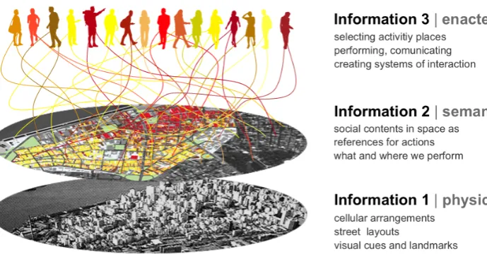
layers (figure 1). 92
93
Figure 1. Environmental information (1) physical space and (2) semantic space, and enacted information (3): substantive components and measurable properties. Colours mean different land uses and types of action, i.e. chronically reproduced modalities of work, commerce, leisure and on, usually materialized as activities occurring in buildings and places (see figure 8).
Classic spatial theories deal with these forms of information to different extents. For instance, 94
Lynch’s [13] ‘image of the city’ operates mostly at the level of information 1, as it deals with paths 95
and physical cues related to cognition and navigation. Hillier’s [14] space syntax grasps patterns 96
of accessibility in street networks relating to cognition, movement and encounter. Haken and 97
Portugali’s [7,8] synergetic inter-representation networks bridge Shannon and semantic information 98
as basis for actions in the city, but without the systemic aspect of social interaction. 99
Our theoretical model places the physical form at the bottom as it provides an elementary but 101
fundamental layer of information related to our cognition and navigation in the environment. The 102
physical layerincludes the arrangement of spatial elements like buildings and streets, and the relations 103
between them. Also, it is a very stable form of information, changing slowly (cf. [12,15]). In turn, 104
thesemantic layerhas to do with how buildings and places support our actions. Its stability depends 105
on how long actions are performed in those places, and how long their meanings are retained in 106
people’s memories, so it changes more easily. Environmental information 1 and 2 are inseparable, 107
but they are not necessarily intrinsic to each other. Although a building is created to support certain 108
activity, it can be used for different activities in time, sometimes with not need for physical adaptation 109
(e.g. a house becomes a shop or an office). So physical information tends to remain, while semantic 110
information depends on ongoing actions and memories afforded by the building. Finally, theenacted 111
layer of information includes the effects that places and their meanings have on agents, bringing 112
possibilities of action [11]. Actions include speech, bodily gestures and the production of signs and 113
objects that carry meaning, and are therefore understandable by other agents, triggering interactions 114
[16,17]. Enacted information is created in the transitions between cognition, action and interaction. It 115
produces and works with environmental information, whenever we use the latter to make individual 116
decisions and communicate. 117
118
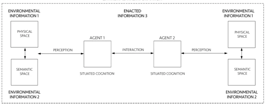
Figure 2. Schematic diagram of a general information-interaction system.
Now let us see what each layer individually is and how they interact as a single system putting 119
minds, cities and societies together (figure 2). The environment that humans create is composed of 120
tangible and non-tangible structures, an interplay of physical spaces (environmental information 1) and 121
meaningful settings of action (environmental information 2). Environmental information surrounds 122
agents 1 and 2. Agents encode information in and decode information from the environment, and 123
they relate to it through theirperceptionandsituated cognition. In turn, cognition is situated because it 124
extends into action and emerges from interactions between agents and their environment. Cognition 125
also emerges from social interactions as distributed processes in collective operations between agents 126
[18] [19]. As we shall see, this extension of cognition into the environment and into how agents 127
coordinate their actions is the very definition of ‘enaction’ [1], what we call enacted information 3. 128
Enacted information 3 encompasses perception, situated cognition and interactions, and it is deeply 129
related to its environment. Of course each of these items and relationships involves a vast literature 130
and need proper, detailed definitions. Let us address them following the three-layered conceptual 131
architecture proposed above. 132
3. Environmental information 1 | physical space 134
Since Shannon’s [20] pioneering work on the mathematical theory of communication and 135
Wiener’s [21] cybernetics, the notion of information took other disciplines by storm in the 1950s and 136
1960s [22]. Shannon arrived at a clear description of information through a probabilistic definition 137
of entropy, also explored by physicist Boltzmann [23] before him. For both, entropy is a measure of 138
the uncertainty of a system. The greater the number of potentially transmitted messages (Shannon) 139
or the number of distinct microscopic states of a thermodynamic system (Boltzmann), the higher the 140
corresponding entropy [24]. Shannon’s definition of information was proposed in the context of the 141
problem of transmission of data, noise and channel capacity, from the point of view of engineering 142
([9], pages 27, 31). He realized that the probability of different arrangements of signs could account 143
for the amount of information embedded in them. Despite the enormous impact of Shannon’s idea 144
in different areas, it has certain implications. Weaver [10] (page 19) himself pointed out that the 145
idea that “greater uncertainty, greater information go hand in hand” seems deeply counterintuitive. 146
Since Boltzmann, entropy is associated with disorder [24,25]. Physical arrangements with higher 147
entropy are characterized by higher levels of randomness, unpredictability or uncertainty. In turn, 148
levels of predictability may be associated with order. Ordered structures contain correlations such as 149
similarities, consistencies and associations that are the ‘substance’ of information [26], like pieces of 150
“coherence above and beyond the bunching and scattering” entities [27] (page 1034). In this sense, 151
information is the pattern of organization of matter and energy [28] (page 10) – like regularities in the 152
arrangement of molecules in a piece of glass, organized parts composing a machine, or the pattern 153
of activity location taking the form of a central business district in a city. A step further, information 154
is a property of recognizable differences and internal correlations in systems that can be decoded by 155
the system itself or by other systems. Information does not require a conscious receiver, but it carries 156
transmissible codes that can guide change in physical processes, behaviour in living systems, and 157
understanding in conscious entities (cf. [29]). It involves intelligibility, but not necessarily ‘meaning’, 158
as Shannon and Weaver [9] correctly asserted. 159
160
The idea that physical things can encode information is not new in theories of cities either. It is 161
at the heart of Lynch’s [13] spatial elements recognized by people, guiding their navigation in the 162
environment, along with memory and representation, even though he did not quite use the term 163
‘information’. Rapoport [30] (page 19) explicitly asserted that “physical elements of the environment 164
do encode information that people decode”. Hillier and Hanson [31] thought of non-representational 165
meaning embedded in physical configurations, as patterns guiding way-finding correlated with 166
patterns of co-presence. Haken and Portugali [7,8] have seen information latent in street layouts 167
and built form. Supposing that these theories are right, the fact that information can be encoded in 168
physical structures is very interesting. Information lasts longer when preserved in tangible entities 169
[26]. If physical spaces materialize information, we would have a form of expressing information 170
continuously – as long as these spatialities are out there. We could encode information in the built 171
environment and decode it while living in it. All these forms of information materialized in physical 172
space could be contextual resources useful to guide our actions. Such a property would open 173
extraordinary cognitive and practical possibilities. 174
175
But how could humans encode information in the built environment in the first place? At 176
this point, there seems to be no definite answer to this question. Research in spatial information 177
seems to mostly focus on how wedecodeinformation from the environment, for instance the role of 178
visual perception, visual variables in navigation, and spatial decision making (e.g. [32,33]). In turn, 179
empirical work in neuroscience has confirmed that the memory of an environment may be stored 180
as a specific combination of place-cell activities [34]. Neural algorithms integrate information about 181
place, distance and direction, forming a directionally oriented, topographically organized neural 182
coincides with any vertex of a hexagonal regular grid spanning the surface of the environment. Grid 184
cells are critical for vector-based navigation, which can be combined with path-based strategies to 185
support navigation in challenging environments. In addition, the mental map is anchored to external 186
landmarks, but it persists in their absence, suggesting that this grid-like position system may be part 187
of a generalized, path-integration-based map of the spatial environment [35–37]. 188
189
In this sense, levels of regularity and predictability in spatial arrangements could be cognitively 190
useful to anchor agents’ internal system of navigation. Agents might capture levels of physical 191
information by recognizing regularity in frequencies of spatial events in the built environment. If that 192
is the case, the greater the variation of elements in the environment, the fewer the regularities that 193
allow inferences about the broader structure. If that is the case, which spatial arrangements contain 194
more physical information? Chess experts show greater memory for chess-typical arrangements of 195
pieces than random arrangements [38]. We suggest that agents create information 1 by engendering 196
levels of order in the deepest constituents of built form, namely cellular aggregations. Imagine a 197
two-dimensional space in the shape of an orthogonal cell grid. Cells occupy positions in this grid, 198
composing different arrangement, like the archetypal cases in figure 3. These arrangements display 199
different levels of order, apparent in the frequency of distances between cells. An extreme case is the 200
orthogonal arrangement (figure 3, case 1). Perfectly regular arrangements like this are rare events in 201
the set of possible arrangements, so they seem like drops of order in a sea of disordered states. In 202
most states, cell distribution tends to contain low internal correlations, like cases 2 and 4. In case 3, 203
positions follow a patterned distribution. Some order is also visible in case 5, a spiraled pattern. The 204
sixth case brings deformed rings, like those found in unplanned urban grids. Capable of generalizing 205
contiguity between cells while keeping permeability, the very formation of such rings is a highly 206
unlikely event. 207
208
Measuring environmental information 1 209
Approaches to visual information have adopted measures of information density and entropy 210
to assess the amount of redundancy and grouping related to cognitive efforts to extract task relevant 211
information [39,40]. We may pursue such possibility measuring levels of predictability in physical 212
arrangements using statistical concepts. A measure of information 1 should be able to grasp 213
regularities and variations in real configurations and different urban situations (figure 4). For this 214
purpose, we suggest to measure Shannon entropy. As we have seen, high entropy corresponds to 215
high levels of randomness or unpredictability. In contrast, the presence of regularities and patterns 216
blue in urban structures corresponds to lower entropy. Hypothetically, cities with ordered structures 217
would help agents understand their environment, allowing them to make predictions about areas 218
beyond their fields of visibility. Agents can make inferences, memorize layouts and navigate more 219
easily from one place to another – say, grasping the pattern of blocks and intersections from local 220
streets and inferring that some blocks away they will still have the same pattern (see [13,14,41,42] on 221
legibility and intelligibility in urban structures; [6,32,33] on pattern recognition and spatial decision 222
making). A measure of spatial entropy can be explored to characterize and classify urban areas and 223
cities from different regions of the world. That is what we attempt to do for a number of archetypal 224
empirical cases. We are certainly aware that a few selected cases do not offer evidence to validate a 225
model. Nevertheless, these empirical analyses are intended as illustrations of the measures at work, 226
displaying their potential utility to capture levels of order and information in spatial arrangements. 227
228
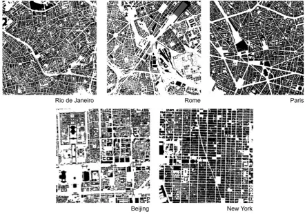
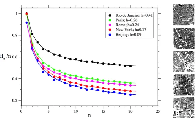
Figure 4. Spatial distributions in real cities (9, 000, 000m2windows, 1000×1000 cells), extracted from Google My Maps. These sections of such archetypal cities will be used to compute Shannon entropy and estimate the degree of disorder in cellular arrangements.
We propose to assess Shannon entropy as a proxy to disorder in cellular arrangements extracted 229
prepared and exported in high resolution, filtering layers and converting entities into solid raster 231
cells. We proceeded to test and analyze trade-offs between resolution, computation and precision in 232
results for distinct scales. We finally chose geographic areas of 9, 000, 000m2. Images underwent a 233
resizing process for 10002cells, were converted to a monochrome system through GIS, and then into a 234
matrix of size 1000×1000 cells with binary numerical values. Then we employed an approach usually 235
applied for estimating the entropy of sequences of symbols encoded in one-dimensional strings 236
[43]. This approach has been widely used for different type of datasets, from natural languages, 237
speech analysis and behavioural sequences to DNA and spike emissions in neurons. However, 238
estimating entropy is far from trivial. For datasets corresponding to one-dimensional strings, the 239
most straightforward method consists in defining the block entropy of ordernby 240
Hn =−
∑
kpn(k)log2[pn(k)]. (1)
where blocks are string segments of sizen, and the sum runs over all the kpossible n-blocks. The 241
Eq. (1) corresponds to the Shannon entropy of the probability distributionpn(k).
242
243
The Shannon entropy of the considered system [43,44] is:
h= lim
n→∞Hn+1−Hn=nlim→∞Hn/n, (2)
which measures the average amount of randomness per symbol that persists after all correlations 244
and constraints are taken into account. This approach can be applied to our problem once we have 245
defined the blocks for a two-dimensional matrix [45]. In this two-dimensional context, the most 246
intuitive idea is to consider a block of sizenas a square which containsncells. To obtain the sequence 247
of Hn also forn values that do not correspond to squares, we will consider blocks that interpolate
248
perfect squares, as described in Figure5. 249
250
Relation2gives precisely the entropy for a theoretical infinite set of data. In real situations where 251
the dataset is finite, our method estimates the probabilities of distinct arrangements of cells within 252
blocks up to a certain lengthn, counting their frequencies, and then estimates the limit. For example, 253
for H1, it is sufficient to have knowledge of the symbol distribution p1(2), which is approximated
254
by the frequency of 0 and 1 present in the dataset. Note that if our data were a purely random set, 255
hwould coincide withH1, and p1(2)would give a full account of the spatial configuration. This is
256
obviously not true for urban situations, where strong long range correlations are present. In this 257
case, estimating entropy is a difficult task, as taking them into account means computing Hn for a
258
largen. In fact, the estimation ofh is good when the spatial range of correlations and memory is 259
smaller than the maximum size of the block entropy we are able to compute. This estimation can be 260
rendered difficult because of the exponential increase of the number of distinct cells arrangements 261
in blocks withn(k= 2n). For instance, there are 512 different configurations for blocks with only 9 262
cells. Difficulties in capturing longer correlations lead to the overestimation ofh. This is the case if 263
sufficient care is used in estimating eachHn. Otherwise, as strong fluctuations are already present
264
for moderate block lengthsn, the estimates Hn are usually underestimated. These two concurrent
265
effects may jeopardize the estimation of entropy. 266
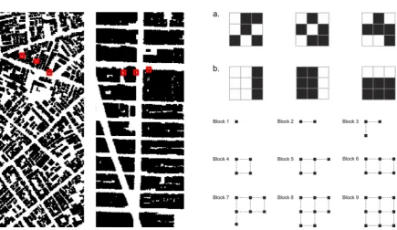
Figure 5. Entropy in configurations of different urban areas: Examples of blocks with 9 cells are shown in red for selected areas in Rio and Manhattan, NY (left), and are amplified on the right. Rio shows a great deal of variation of configurations like (a). In turn, configurations like (b) are frequently found in Manhattan. Essentially,pn(k)in equation1accounts for the number of times every possible configurationkappears in the map for a block of sizen. A high frequency of certain configurations, like in Manhattan, brings the entropy measure closer to 0, i.e. to higher levels of physical order. This procedure for estimating entropy was applied for blocks with different sizes (i.e. number of cells, below on the right). Here we show the first nine blocks; other block sizes were generated through this approach. Note that there is no unique natural way to scan a 2D matrix [45]. Different forms of interpolating cells do not seem to influence the estimation ofHn.
In our specific case with just two symbols, the estimation ofHn is surely not reasonable when
268
2n ≈ N, whereNis the number of elements in our dataset [44]. So in our situation where we work 269
with a matrix with 106 cells, this condition is verified forn ≈ 20, which means blocks of squares 270
with a linear length smaller than 5 cells, which corresponds to 15 meters (m). It follows that if a 271
city has internal correlations larger than 15m, the entropy estimation using block entropy will be 272
over-estimated. Results for the estimation ofHn/nand the corresponding entropyhfor areas in five
273
selected cities are shown in Figure 6. 274
275
The north area selected in Rio de Janeiro shows the highest level of disorder among selected 276
areas of cities. This implies a lower level of physical information. To a large extent, these results 277
make empirical sense. However, it is less clear why Manhattan would have higher disorder than 278
the area selected in Beijing, given the highly regular grid structure of the former. The reason for this 279
finding can be ascribed to the maximum size of the block of cells used for estimating entropy in our 280
method, which has a linear size much smaller than the actual urban blocks in Manhattan. Limited to 281
the considered cell blocks, our measure is only able to capture sections of Manhattan’s large urban 282
blocks, which consist of very regular alignments of cells on their external borders, but irregular 283
arrangements on their interior. In turn, Beijing’s urban blocks display more variations in shapes and 284
sizes, but are very regular on their external border and interior arrangements. 285
286
Finally, this approach allows us to use different sizes of cell blocks for measuring physical 287
Figure 6. Measuring environmental information 1: estimated values ofHn/nfor areas in five selected cities. Continuous lines represent the best fitting of our data using the function: a+b/nc. The fitted values ofagive a reasonable extrapolation of the Shannon Entropyhof the dataset. Values are reported in the legend. The selected area in Rio de Janeiro shows the highest level of disorder (lower level of physical information) among areas in five selected cities.
similar for blocks with one cell for all analyzed urban areas, suggesting that such cities, selected 289
from different regions and spatial traditions, share a similar proportion of empty and built cells. This 290
surprising finding must be confirmed for larger samples of cities. In turn, block sizes larger than 291
one cell showed stronger differences in block entropy levels between cities, as expected. Differences 292
in values were more pronounced as block sizes increased. These results are consistent with the 293
general expected behaviour for block entropies in dependence of the block size for any system. It is 294
interesting to note how physical information can be grasped even at small scales and that disorder 295
is shown to decrease as the size of cell blocks analyzed increases, as larger scales of order and 296
correlation begin to matter. 297
298
If we wish to improve the statistical robustness of our analysis by increasing the number of cells 299
in our dataset, we can follow two paths. The first is increasing map size. However, this is limited by 300
the size of cities and by the fact that we need relatively continuous urban areas in order to compare 301
them. Large geographical interruptions like mountains or lakes may interfere with the frequency 302
of blocks configurations, and should be avoided. The second is increasing map resolution. In this 303
case, we must increase the maximum value of n. However, the presence of large homogeneous 304
features and the noise produced by finer resolutions increase fluctuations in the estimation of the 305
block entropy, leading to a strong underestimation of entropy. Measures of spatial information can 306
also be introduced through analysis of the fractal dimension of urban structures [46]. Nevertheless, 307
claims of fractality are often made for data that only represent a limited range of scales [47] [48]. The 308
characteristic scale of the urban block poses challenges to the idea of self-similarity – for instance, 309
between blocks and the larger spatial structure of Manhattan. A step further, fractal properties are 310
usually found in data characterized by larger scales than the ones we are analyzing in this paper. 311
Therefore, we choose not to connect spatial information with an approach to fractals in this work. 312
Finally, the method we use for estimating Shannon entropy in spatial configurations does not depend 313
on a particular scale. This condition is based on its very formulation and it is proven by the fact that 314
it has been successfully used for estimating entropy in systems that present self-similarity [49]. 315
At this stage, our approach takes account of the physical information latent in the arrangements 317
of cells capturing relations of proximity, but eventually missing some correlations at large distances. 318
However, cellular growth shapes larger structures and paths as fundamental morphological features 319
of cities – a subject explored in other works [7,41,50,51]. In addition, there are other forms of physical 320
information, such as three-dimensional differences between buildings, physical cues and landmarks 321
[52,53]. Forms of estimating the effects of such aspects of physical information will be subject for 322
further work. Levels of regularity in physical space seem useful informational features in cognition 323
and navigation (cf. [7,8,14]). But are they all that the environment can offer? There might be a limit to 324
the extent of information that physical space can encode, even if ordered to preserve information. 325
Environmental information needs to be more differentiated out if it is to get closer to levels of 326
differentiation found in actions. So how could urban space support more information? 327
4. Environmental information 2 | semantic space 328
A number of theories have attempted to expand Shannon’s pioneering ideas on information 329
as messages comprising symbols encoded in well-formed strings of signals into different types 330
of information theory, in a way to deal with the second communication problem pointed out by 331
Weaver [10] (pages 4, 26). That would be the existence of another aspect to information related to 332
the interpretation of transmitted signs, or “how precisely do the transmitted symbols convey the 333
desired meaning”, involving a receiver able to subject the message to a second decoding. Indeed 334
the specificity of semantic information requires clarification about its place among different types of 335
information theory. In this sense, Floridi [54] identifies three fundamental concepts: (i) information 336
aswell-structured data; (ii) information as meaningful well-structured data; and (iii) information as 337
meaningful andtruthfulwell-structured data. Shannon’s theory falls into the first category, since it 338
deals messages comprising uninterpreted symbols. The second category consists oftheories of weakly 339
semantic information(TWSI). Finally, theories that place truth as a condition for information fall into 340
the third category, ‘strongly semantic information’ (TSSI). Our approach to (environmental) semantic 341
information falls into the second category: one can encode and decode semantic information from 342
the environment with no resource to statements of truth or untruth. Truth statements do no apply 343
since environmental information does not depend on them to be cognized by agents. 344
345
Let us look into these theories a little closer. The first attempt to deal with the semantic problem 346
of “what symbols symbolise” involving contents or designata of symbols can be found in Carnap and 347
Bar-Hilliel’s [55] (page 147) formal theory of semantic information. They connected a probabilistic 348
notion of information with the contents of statements in language systems. Later on, Mackay [56] 349
proposed a quantitative theory of qualitative information. Interestingly, Barwise and Perry [57,58] 350
and Dretske [59] have developed such possibilities into a theory: situation semantics. ‘Situations’ 351
are limited parts of the world: events and episodes are situations in time, and scenes are visually 352
perceived situations [57]. Situation theory is geared to address the way context facilitates and 353
influences the rise and flow of information [60]. 354
355
Dretske adapted elements of Shannon’s theory to produce a theory of semantic information in 356
which semantic content reduces to theintentional contentof information, i.e. physical signs used to 357
transmit encoded symbols produced by a source have intentional content. Furthermore, and also 358
of great interest to our approach, semantic information in Dretske’s sense can also exist as a feature 359
independent of a single, individual mind, and can be quantified. Of course places may hold different 360
meanings for different people. Like the understanding of words [19], two people probably will not 361
share a same semantic understanding about a place or an environment. A bar may be special for you 362
because you met your wife for the first time there, and I will never know that. The reason for this 363
is that meanings do not lie only in space: they also lie in people’s heads. That means that we could 364
even though the meaning of a place is associated with subjective interpretations, we can access its 366
conventional meaningas a social construction. Meanings are also collectively encoded and shared in 367
urban space. I cannot access the special meaning that bar holds for you, but we both realize that that 368
place is a bar, encoded with this social meaning by the kind of recursive actions performed there. 369
370
This is known assemantic environmental information. Situation theorists require some presence 371
of information immanent in the environment[54]. The situation supports information: the context 372
contributes to the meaning performed in that context, and vice versa [16,60–62]. This is a powerful 373
condition. An environment semanticized by meanings-in-use brings its informational potential to a 374
direct relationship with action. People can recognize the meaning of a place in traces and artefacts left 375
by previous or ongoing actions, and associate these traces with their spatial milieu. Space not only 376
representsthe activity, it is alsoenactedand, as such, laden with meanings. Spaces can ‘mean’ as much 377
as our actions, because they are semanticized by our actions. And because space is semanticized by 378
our actions and share the same informational nature, at least in part, it finds a level of differentiation 379
similar to types of actions (see [7,63] on semantic categorization). Semantic information renders the 380
environment endogenous to action[64,65]. 381
382
The physical environment takes on meaning when spatial features stand for some social 383
content, and trigger associations with actions. But what is the informational potential added by 384
semantic meanings encoded in the physical environment? We could think of the difference between 385
environmental information 1 and 2 like the difference between a black and white image and a 386
colour image. In comparison with tones of grey, colours are more diverse and contrasting. New 387
possibilities emerge as each colour finds its own palette of tones, leading to an enormous increase in 388
combinatorial possibilities within such distributions (figure 7). 389
390
Figure 7. Colours find their own palette of tones, becoming more diverse and contrasting in the passage from grey to colour scales, leading to an enormous increase in combinatorial possibilities. Photo: Vincent Laforet.
Many studies in cognitive science and spatial information theory have asserted associations 391
between physical features and semantic contents in cities. Certain cognitive processes trigger 392
associations with elements of the environment through the incorporation of socially acquired 393
information [66,67]. Information is classified into potentially shared categories [7,60,68]. Non-spatial 394
information can be integrated or associated with spatial information [69], as semantic categorical 395
grouping processes relate to spatial features such as roads to organize point-based locations 396
[63,70–72]. Such form of ‘semantic clustering’ can have effects on the memory of spatial locations 397
[73]. The probability of a building or place to evoke a collectively shared mental representation is 398
environment and the social information associated with activities performed there [6,74,75]. In short, 400
in perceiving a building, we perceive not only its form, but also the potential information enfolded 401
in it [7]. We load the built environment with information. Our knowledge of spatial properties 402
and patterns can integrate semantic, visual, and configurational aspects projected into an urban 403
environment as ‘symbolic off-loading’ (cf. [3]). A non-physical thing like meaning may control and 404
change the physical world [76]. 405
406
But what does semantic environmental information do for our actions? Semantic associations 407
with places increase the power of the environment to inform us [67,69,73]. For instance, we recall a 408
restaurant more easily if we know that it is located beside a mall or another restaurant. Locational 409
patterns like that work cognitively: activities from a same industry will frequently locate near 410
each other whether they compete or establish forms of complementarity by similarity [77], either 411
way attracting more potential attention than if they were dispersed and isolated. Importantly, 412
different forms of specialization frequently overlap within a same area [78–80]. A heightened 413
amount of semantic information can be found both in the concentration of diverse activities and the 414
specialization of areas [81]. If an area has more dense and diverse activities, our chances of finding 415
something we need increase, and we can guess that from visual and semantic cues. In other words, 416
encoding the physical world with semantically structured models brings advantages. It enables us to 417
buildinferences. This property is crucial for our actions. Diverse and concentrated activities in urban 418
areas trigger more possibilities [52]. People can build instructions about such possibilities in the 419
environment in an indexical form [82]. Agents can find cognitive and practical synergy manifested in 420
the form of proximity, categorical grouping and clustering [83]. Local adjacencies between different 421
activities may create interesting complementarities from the point of view of agents in their efforts to 422
perform and coordinate their actions. 423
424
Measuring environmental information 2 425
Semantic similarity has been proposed as a measure to determine the difference between feature 426
type definitions [83,84]. We argue that a key point is to measure thediversityof social contents in 427
buildings and places. We propose to deal with such shared meanings through semantic maps [85]. 428
Semantic maps can represent any form of social content in urban space, including kinds of interaction 429
in activity places. They do not necessarily capture individual interpretations and private memories 430
of places, but they can capture their social meanings. These meanings are part of the knowledge 431
of a social world and its environment, and should be enough to support our understanding of the 432
collective role of places, i.e. their role in supporting actions and interactions. Like any kind of 433
social and environmental knowledge, it must be built heuristically in situation-based behaviour in 434
our daily interactions and context [6,18,86,87]. For simplicity, we choose classic categories in urban 435
studies, namely land uses varying from public squares to residential buildings, and apply them in 436
the empirical analysis of two archetypal urban areas (figure 8, left). Land uses are variables usually 437
employed in analytical procedures in urban modelling. 438
439
Semantic information can be measured as levels of diversity found in land use distributions, 440
analyzing local adjacencies between neighbour cells. In principle, we could do so by measuring 441
entropy using the same procedure used for information 1. Unfortunately, the fact that now we should 442
analyze a system characterized by more than two numerical values is an obstacle for a reasonable 443
estimation of frequencies, which limits the effective possibility of estimating theh values. For this 444
reason, we suggest a different measure. For each celljwe define a block of cells correspondent to a 445
square of linear sizem, centered inj. Inside this square, we measure the land use distribution, which 446
block. For instance, in both cases in figure8there arez= 8 types of land use. Then we estimate the 448
value ofHmj for thej-th position, given a neighbour cell of sizem: 449
Hjm=−
∑
z
fm(z)log2[fm(z)]. (3)
Note that even though this measure has some analogy with the previous entropy estimation, it is 450
indeed different. We are simply measuring an entropy-based scalar index for characterizing the local 451
distribution of different land uses in a given neighbourhood ofj. This process can be run for all cells 452
present in the matrix, and it is analogous to some algorithms used in image processing. A graphic 453
analysis representing all the estimatedHjmvalues can be produced. Applying this approach to these 454
two archetypal cases, we obtain results seen in figure 8 (right). 455
Figure 8. Semantic maps: real distribution (top) and fictitious distribution (bottom) of land uses in Porto Alegre’s CBD, Brazil on. CorrespondingHm
j values are shown on the right. Entropy values shown on the right (from blue to red) are calculated with equation 3. Values are calculated form=10, with the celljcorresponding to a pixel of the maps on the left. The calculation is run over a gray-scale copy of the maps. Source: Authors based on [77].
The graphic analysis identifies cells of high diversity in both maps, corresponding to local 456
interfaces between land uses, a form of information potentially attractive to agents. However, the 457
real distribution contains a higher number of spots of cells of diverse semantic information than the 458
fictitious one. This distinction suggests the potential usefulness of this method to capture levels of 459
information 2 in different distributions of social contents in cities. Nevertheless, let us see how these 460
two forms of environmental information can be part of interaction. 461
5. Information 3 | enacted 463
Reminding Weaver’s [10] third problem of communication (“How effectively does the received 464
meaning affect conduct”), we finally reach the problem of how agents use environmental information 465
1 and 2 to interact. We called this ‘enacted information’ or information 3. The term ‘enaction’ can be 466
found in a number of approaches, from Bruner’s (1966) description of knowledge as acquired and 467
manifested through action to Varela’s [1] ‘paradigm of enaction’. Our use of the term shares aspects 468
especially with the latter. The approach relates to emerging paradigms based on ‘embodiment’, 469
‘situatedness’, and the relevance of cognition for action [3,88]. Enaction is ‘embodied’ in the sense 470
that cognition depends upon the experience of a body with sensorimotor capacities ‘situated’ in a 471
more encompassing biological, psychological and cultural context [1]. A step further, agents enact 472
their cognitive domain by actively and asymmetrically regulating the conditions of their exchange 473
with their environment. Enactive approaches evolved in opposition to computational cognitivism, 474
and reject the traditional pole of seeing the mind as only responding to environmental stimuli [19]. 475
Instead, enactive approaches focus on how sensory inputs from the environment guide actions, and 476
actions modify sensory returns and the environment itself, in perception-action loops. Interaction 477
with the physical and social environment would make measurable differences in cognition and vice 478
versa [1]. 479
480
Embodied interaction is also emblematic in enaction research. It is seen as ‘mutual participatory 481
sense-making’ involving the emergence of roles, values, dispositions to act, and meanings [1]. 482
Meaning belongs to the relational domain established between the internal dynamics of the agent 483
and elements in the environment. It is inseparable from the context-dependent, embodied activity, 484
without being beyond the reach of scientific understanding. Agents “cast a web of significance on 485
their world”: exchanges with the world are inherently significant for the agent. In turn, meaning is 486
derived from information processing. Through meaning and interaction, agents extend beyond the 487
strict confines of their bodies, into the socio-linguistic register [1]. 488
489
At this point we reach a key problem in enactive approaches: how coordination emerges between 490
agents. The emission and reception of signals in language gives rise to the modulation and 491
coordination of actions. Interestingly, there is communication only if signal-mediated interactions 492
result in coordination of actions [89]. The semantic layer of information endows the enactive layer 493
with a fine-grained medium to convey meanings in communication, and vice versa [11]. This 494
inherent connection is consistent with previous approaches we have seen, namely the idea that 495
agents rely on environmental information to perform. 496
497
But what exactly is the practical role of environmental information in the coordination of 498
actions? Does it have to do with interaction and the creation of systems of interaction? We have 499
seen that buildings and places mediate interactions. A physically and semantically structured 500
space becomesthe referential frame that provides a form of organization to the field where interactions are 501
performed. Places become nodes in the unfolding connections between actions. These connections 502
end up amounting to networks of interactions between places, and between people and what they 503
do. Let us see how this happens. Think of a place you might go in your daily life — say, in a busy 504
street a couple of corners away from your home. When you choose that place and go there, you 505
join a situation that culminates vast networks of previous interactions that you never thought about, 506
but were a condition for you to be there at that moment. Now you have not got there by sheer luck 507
or fate. The physical and semantic environment has informed you that that place could exist, and 508
that it was a possibility for your action, a means to join a social situation and take part in the huge 509
system of interactions that structures the world around you. The physical and semantic environment 510
plays an active part in how you and other agents there managed to reach some agreement or do 511
other situations. What happens there tends to have ripple effects, with actions and their outputs 513
connecting to other actions and places, merging into a system of interactions than unfolds in larger 514
scales through different media, including the built environment of cities. In short, environmental 515
information becomes a means of social organization — or, in information theory terms, a means of 516
reducing (social) entropy. 517
518
Now, given the enormous number of possibilities of interactions in a city [51], how precisely 519
can the environment inform us and help us select counterparts for our interactions? How much do 520
different physical patterns (information 1) affect this combinatorial process? Would different levels 521
of diversity in activities (information 2) have different effects on levels of entropy in people’s actions? 522
We propose to assess probabilities of combinations of actions in different spatial scenarios, such as 523
those in figure 9. 524
525
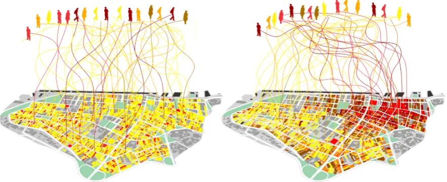
Figure 9. Diagram of agents converging in a fictitious, nearly random distribution (left), and in a real, patterned one (right).
One way to do this isquantifying the amount of environmental information available for agents in their 526
decisions. We tested this idea through an ‘enaction model’ able to assess information 3 proposed in a 527
companion article [90]. Like situation semantics, our model considers agents, types of action, spatial 528
and temporal locations, situations (represented by activity places) and parameters able to capture 529
aspects of the agent’s cognitive behaviour, namely the ability to track and recognize social situations, 530
make decisions based on their individual orientations, and change their own actions and the semantic 531
environment. Our agent-based model (ABM) based on a city as a linear structure is able to represent 532
the minimal sufficient aspects of environmental information 1 (physical distance between positions 533
representing places) and information 2 (semantic differences in the information contents of cells). 534
The linear form of this city allows continuous movement across a sequence of locations, eliminating 535
centrality factors while taking into account periodic boundary conditions in order to reduce border 536
effects, eliminating the role of topology while isolating the problem of physical distance [91]. Our 537
hypothesisis that, as (a) physical proximity latent in environmental information 1 tends to increase 538
interactions between agents [92–94], its association with (b) environmental information 2 created 539
by diversity in locational patterns increases the potential for interactions and the coordination of 540
actions, leading to reductions of entropy in enacted information 3. 541
542
In each time-step, agents select and visit a specific cell within the city. The decision on which 543
action to perform next may be influenced by three different conditions: namely, (i) latent orientation, 544
of how to act, shaping (along with short-term memory) current actions. They are initially randomly 546
distributed, and this condition remains over time. (ii) Current action performed by an agent as 547
she selects an activity place in order to perform a new action; this means an influence of the 548
current action, while allowing gradual changes of orientation in time influenced by other agents 549
and activities. (iii) Activity places where agents perform specific types of action. Agents select 550
activity places closer to their latent orientations and current actions, while being influenced by those 551
activities. Visiting agents also influence places, but places change at a slower rate. In other words, 552
agents co-evolve with their semantic environment. 553
554
Let us see how action orientations change in time t. Action orientation for agent i – from a 555
population of N agents – is represented by σi(t); while the type of activity in a place located at
556
the position x, is represented by σx(t). We quantify and update the action orientations of agents
557
weighting three variables: i)latent orientationσiin, which does not change in time; ii)current action
558
σi(t); and iii)activity placeσx(t). Orientations will be updated according to the rule:
559
σi(t+1) =ασiin+βσi(t) +γσx(t), (4)
whereα,βandγare parameters of the model. The activity in places will be updated according to the
560 rule: 561
σx(t+1) =σx(t) +θ
∑
i∈x
σi(t), (5)
where the sum runs for all agents in placexat timet. Parameterθis a sufficiently small quantity to
562
grant that changes in activity places will be slower than changes in the actions of agents. In short, 563
places are less influenced by agents than the other way around. This means that at every time-step, 564
a place would have its activity closer to the average of orientations of its visitors. Agentichooses a 565
place to visit at timetbased on the similarity (i.e. numeric proximity) of her action orientation and 566
the activity ongoing in a place. A possibility is to consider that agentichooses to visit a place that 567
minimizes the functionEi(x,t) =|σi(t)−σx(t)|.
568
569
Our ABM simulated two kinds of scenarios: a first one where an aspect of physical information, 570
namely the proximity between activities does not matter to agents in their decisions or amaterially 571
inactive space; and a second one where proximity matters in a materially active space. In the first 572
scenario, the agent chooses a place to visit based only on the similarity between her action orientation 573
and the activity located in space, i.e. minimizingEi(x,t) =|σi(t)−σx(t)|. In the second scenario, the
574
agent will take into account not only similarity, but the physical distance to the activity located atx, 575
giving preference to closer places of a similar type. For example, in this scenario an agent will choose 576
the place that minimizes the functionEi(x,t) = |(xi−x)·(σi(t)−σx(t))|. Summing up, an agenti
577
selects at timeta particular activity located atxthat minimizes the functionEi(x,t).
578
579
Enacted information is measured as a function of entropy: considerN(σ,t)the number of agents
580
with an action orientationσat the timet. The total population isN= ∑σN(σ,t)). We can compute
581
the frequency (or density)ρ(σ,t)of this orientation within a population with:
582
ρ(σ,t) = 1
NN(σ,t). (6)
583
584
The entropy level for any distribution of orientations is: 585
S(t) =−
∑
σ
ρ(σ,t)ln
ρ(σ,t)
586
587
This describes how uneven is the probability of finding different action orientations. Higher 588
entropy values mean that different actions types have almost the same probability to occur, while 589
lower values indicate a social system with trends towards a convergence of orientations between 590
agents. The reduction of entropy implies that the probability of certain actions increases, that is, 591
actions grow in similarity. In the limit, as entropy falls to zero, all agents in the system would reach 592
a same type of action. Differences in the weight of latent orientation, current action and the activity 593
place over the next action may lead to quite different levels of social entropy in simplified systems of 594
environmental and enacted information. Figure 10 shows the probability distribution of action types 595
in our two kinds of scenarios. Scenarios where proximity matters show a dramatic increase in the 596
coordination of actions. Results are averaged for 30 runs for each of 125 combinations of parameters. 597
598
start of simulation
type of action
end of simulation
0.0000 0.0005 0.0010 0.0015 0.0020
0 250 500 750 1000
0.0000 0.0005 0.0010 0.0015 0.0020
%
o
f
to
ta
la
ct
io
n
s
type of action
0 250 500 750 1000
%
o
f
to
ta
la
ct
io
n
s
materially inactive space
materially active space
Figure 10. Histograms of probability distribution of action types show high levels of entropy at the start of simulations (left) in two kinds of scenarios: where proximity between activity places matter to agents (red line), and where proximity does not matter (blue line). At the end of simulations (right), scenarios where space is materially active show convergences around certain types of action, indicating a general reduction of entropy and an increasing coordination of actions [90].
Our results show structure in the relation between selection factors and the reduction of 599
entropy in actions. Urban space materializes gradients of difference in potential actions, from 600
less to more recognizable, costly or likely. Placing simple criteria like proximity as an aspect of 601
physical information in selecting activities, our model shows that space increases the chances of 602
certain selections to happen. Environmental information ‘contaminates’ agents: they are likely 603
to align their actions through the criteria of proximity and the informational content of places. 604
This general reduction of entropy implies that the probability of certain interactions increases. In 605
practical terms, this means more alignments between agents. As an information environment, the 606
physical and semantic environment creates differences in the probabilities of interaction, helping to solve the 607
combinatorial problem of connecting actions into a system. 608
609
6. From information to interaction: concluding remarks 610
In this paper we attempted to understand how humans use information in their environment 611
in order to live together and create systems of interaction. We did so (a) proposing a three layered 612
model of information in cities; (b) developing measures for each of the layers and tested them in 613
selected empirical cases from different regions; and (c) exploring an ABM to simulate how aspects of 614
physical and semantic environmental information affect the coordination of actions or social entropy. 615
Previous works dealt only with aspects of these relations, like spatial paths and physical cues related 616
to cognition and navigation [13], patterns in street networks related to cognition and encounter [14] 617
and synergetic networks as basis for actions in the city [7,8], but without the systemic aspect of social 618
social systems as comprehensively. 620
621
More specifically, inspired by Weaver’s [10] levels of communication problems, we addressed 622
the relation of minds, cities and societies through three questions: (i) how do we encode and decode 623
information from the physical environment? (ii) How do we make environmental information 624
meaningful? (iii) How do we use environmental information to interact? Methodologically, answers 625
to these questions involved three procedures: assessing information 1 in physical space; assessing 626
information 2 in the distribution of contents in semantic space; and modelling how agents deal with 627
environmental information 1 and 2 in order to coordinate actions in information 3. Developing 628
a framework to answer those questions, we explored different strands of information theory and 629
cognitive studies, from Shannon’s theory of well-structured data to Dretske’s situation semantics and 630
Varela’s concept of enaction, and did so in the following directions: 631
1. We measured environmental information 1 in cellular arrangements as levels of order through 632
Shannon entropy, seeing cities with more disordered layouts encoding higher entropy levels and 633
therefore less information useful to guide navigation. 634
2. We measured environmental information 2as a function of semantic diversity in local relations 635
between activity places: location patterns associated with diverse activities encode higher 636
amounts of information. Information 2 is highly differentiated, serving as a combinatorial 637
resource in the process of selection of places and actions to be performed. 638
3. We modelled the influence of the environment inenacted information 3, simulated as action types 639
in an ABM. Proximity in physical configurations in information 1 and semantic contents in 640
information 2 were seen to increase coordination in interaction systems. Contrary to isolated 641
systems where order inexorably dissipates in time, the entropy of action types decreases as the 642
social system is open to and co-evolves with its physical and semantic environment. Aspects of 643
information 1 and 2 find roles in the combinatorial problem of interaction. 644
A number of procedures are underway for further developing this approach. First, we intend to 645
expand the approach to information 1 into broader spatial structures in cities – assessing measures 646
of visibility [14] and the entropy of angular variation in street networks [42]. We also wish to go 647
beyond regularity and entropy, and introduce more sophisticated measures of statistical complexity. 648
Second, we hope to expand the approach to information 2 beyond diversity, looking into the effects of 649
specializationandconcentrationof activities, especially those with power to attract agents looking for 650
functional complementarity. Another issue is the integration of physical and semantic environmental 651
information. Recent approaches have paid attention to this relationship in different ways [8,83]. 652
Information 1 seems associated with orientation and navigation, while information 2 seems closer to 653
the perception and selection of performance opportunities. They also change according to different 654
temporalities. These forms of environmental information are deeply associated but cannot be 655
reduced to one another. Relations between configuration, physical cues and semantic references 656
remain a key area for further study. 657
658
We also expect to develop a database of environmental information for a large number of cities 659
from different regions of the world, which will allow us to systematically assess them as informational 660
resources, an aspect of urban, social and economic performance. We hope to seewhether different cities 661
carrying different levels of environmental information could affect how inhabitants perform and coordinate 662
their actions. Our hypothesis is that certain environments would ease cognition, navigation and 663
efforts of interaction. Finally, these three forms of information, particularly information 3, are hard to 664
assess empirically. In order to validate this model, we hope to explore the heuristics of how people 665
actually perceive and enact information in the built environment through cognitive experiments 666
performed in Virtual Geographic Environments (VGE) [86,95]. 667
Interaction systems require a high capacity to access and recombine information into on-going 669
and future connections. They are ‘information-hungry’. This dependence requires different types 670
of information. Environmental information seems to play a part in the continuous creation of 671
interactions. The fact that cities preserve social information in durable space and in soft semantic 672
structures would help order grow. Only by means of a structure that restricts the quasi-endless 673
combinatorial possibilities of interaction, this system can acquire sufficient internal guidance to make 674
its own reproduction possible. By distributing sufficiently recognizable differences in the probability 675
of interactions, cities ease the local reproduction of a society. The city helps us convert information 676
into interaction. In fact, the interfaces of cognition, environment and action reveal a deep connection. 677
Self-organizing in themselves, they also seem co-dependent – and more. They seem to shape each 678
other and emerge as an integrated system in its own right. This integration of minds, cities and 679
societies happens through information.Information is the bridge. 680
681
Acknowledgments:The authors would like to thank the Ecole Polytechnique Federale de Lausanne (EPFL) and 682
CNPq for financial support. We also thank Romulo Krafta, Juval Portugali, Sophia Psarra, Mike Batty, Alan 683
Wilson, Elsa Arcaute, Lucas Figueiredo, Fred Holanda, Sam Griffiths and Kayvan Karimi for comments and 684
discussions of this work; and Vinicius Gomes, Ana Luiza Mazalotti, Gabriela Inocente and Larissa Fernandes for 685
empirical support. F. L. Ribeiro acknowledges CAPES (process number 88881.119533/2016-01), CNPq (process 686
number 405921/2016-0) and FAPEMIG for financial support. 687
Author Contributions: Vinicius M. Netto conceived the theoretical model and wrote the paper; Edgardo 688
Rigatti developed mathematical measures, analyzed data and contributed text parts about measures and 689
data; João Meirelles contributed to the theoretical model, designed the computational model, analyzed data 690
and contributed text parts about model and data; Fabiano L. Ribeiro developed mathematical measures and 691
contributed text parts about measures; Bruno Pace contributed to theoretical discussions; Caio Cacholas and 692
Patricia Sanches contributed analysis tools. 693
Conflicts of Interest:The authors declare no conflict of interest. 694
References 695
1. Varela, F.; Thompson, E.; Rosch, E. The embodied mind: cognitive science and human experience; MIT Press, 696
1991. 697
2. Lakoff, G.; Johnson, M.Philosophy in the Flesh; Vol. 4, New york: Basic books, 1999. 698
3. Wilson, M. Six views of embodied cognition. Psychonomic bulletin & review2002,9, 625–636. 699
4. Robbins, P.E.; Aydede, M.E. The Cambridge handbook of situated cognition; Cambridge University Press, 700
2009. 701
5. Clark, A.; Chalmers, D. The extended mind. Analysis1998,58, 7–19. 702
6. Portugali, J.Complexity, cognition and the city; Springer Science & Business Media, 2011. 703
7. Haken, H.; Portugali, J. The face of the city is its information. Journal of Environmental Psychology2003, 704
23, 385–408. 705
8. Haken, H.; Portugali, J. Information adaptation: the interplay between shannon information and semantic
706
information in cognition; Springer, 2014. 707
9. Shannon, C.E. Communication theory of secrecy systems. Bell system technical journal1949,28, 656–715. 708
10. Weaver, W. Recent contributions to the mathematical theory of communication. InThe mathematical theory
709
of communication; Shannon, C.E.; Weaver, W., Eds.; Urbana: The Illinois University Press„ 1949; pp. 1–28. 710
11. Kuppers, B.O. Elements of a Semantic Code. InEvolution of Semantic Systems; Springer: Heidelberg, 711
Germany, 2013; pp. 67–86. 712
12. Hinton, A.Understanding context: Environment, language, and information architecture; O’Reilly Media, Inc., 713
2015. 714
13. Lynch, K.The image of the city; Vol. 11, MIT press, 1960. 715
14. Hillier, B.Space is the machine; Cambridge University Press, 1996. 716
15. Brand, S.How Buildings Learn: What Happens After They’re Built; Penguin, 1995. 717
16. Habermas, J.The theory of communicative action; Vol. 1, Polity Press, 1984. 718
17. Luhmann, N.Social systems; Stanford University Press, 1995. 719