http://dx.doi.org/10.4236/jgis.2016.84043
Automatic Extraction of Urban Road
Centerlines from High-Resolution Satellite
Imagery Using Automatic Thresholding and
Morphological Operation Method
Abdur Raziq, Aigong Xu, Yu Li
School of Geomatics, Liaoning Technical University, Fuxin, China
Received 19 July 2016; accepted 21 August 2016; published 24 August 2016
Copyright © 2016 by authors and Scientific Research Publishing Inc.
This work is licensed under the Creative Commons Attribution International License (CC BY).
http://creativecommons.org/licenses/by/4.0/
Abstract
The commercial high-resolution imaging satellite with 1 m spatial resolution IKONOS is an impor-tant data source of information for urban planning and geographical information system (GIS) ap-plications. In this paper, a morphological method is proposed. The proposed method combines the automatic thresholding and morphological operation techniques to extract the road centerline of the urban environment. This method intends to solve urban road centerline problems, vehicle, vegetation, building etc. Based on this morphological method, an object extractor is designed to extract road networks from highly remote sensing images. Some filters are applied in this experi-ment such as line reconstruction and region filling techniques to connect the disconnected road segments and remove the small redundant. Finally, the thinning algorithm is used to extract the road centerline. Experiments have been conducted on a high-resolution IKONOS and QuickBird images showing the efficiency of the proposed method.
Keywords
Automatic Thresholding, High-Resolution Imagery, Morphological Operation, Posts Processing, Thinning Algorithm, Urban Road Centerlines Extraction
1. Introduction
planning and land management, vehicle navigation, to transportation safety, hazards, and disaster management. With the advent of satellite remote sensing images are capable of collecting and providing a huge volume of da-ta to analyze global information, which is quite a difficult da-task based on conventional mapping techniques, aerial photographs using mostly, which defends on the weather condition and photographic scales. These techniques are time-consuming and costly to fly on the regular basis, especially for urban road centerline updating and change detection in the urban area with rapid construction and destruction. However, a new generation of high- resolution satellite images provides one way by which large area may be mapped correctly and efficiently to mi-nimize the cost and save the time.
Recently, high-resolution commercial imaging satellites have been launched ranging from (0.6 - 4 m), in-cluding IKONOS (1 m panchromatic and 4 m multispectral) in 1999 and QuickBird (0.6 m panchromatic and 2.4 m multispectral) in 2001. In the next few years, there are several other satellites which will be launched, in-cluding optical imaging satellite such as KOMPSAT-2 (1 m panchromatic and 4 m multispectral) and Orbview 3 (1 m panchromatic, 4 m multispectral) and radar imaging satellite such as RADARSAT-2 (3 m) Canadian satel-lite and Terra SAR (1 m) European satelsatel-lite.
The authors [1] [2] presented initial studies which indicated that it is possible to use 1 m resolution satellite imagery to identify, interpret, and extract selected urban objects at 1:2000 scale in all classes of an area (densely populated urban cores, suburban residential areas). In addition, their high temporal resolution (short orbital revi-sit period, e.g., 1 - 3 days) makes these images ideal source for change detection and hazard assessment. These satellite sensors provide stereo and multispectral information that is useful for automatic road extraction, terrain modeling, and 3D scene analysis.
Automatic urban road network extraction from high remotely sensed data is motivated, in particular, by the rapid demand for accurate and up-to-date mapping application related to urban planning and traffic flow analysis and simulation, road maintenance and/or rehabilitation, estimation of air and noise pollution. Acquiring map-ping-quality digital images from space to allow frequent geographical information system database updating is half the battle in urban environmental management. The other half is extracting information from the imagery. Automatic extraction of urban road provides a challenging task for geomatic and mapping engineers. Satellite remote sensing techniques provide efficient information concerned to the road to improve the transportation of urban and suburban areas.
In the last three decades, the application of high-resolution satellite images has been explored in the area of information extraction such as building and road network. Nowadays the high-resolution satellite data have be-come easily available for commercial purposes and for the researcher. Therefore, it helps to recognize the urban roads, for applications in transportation and computer vision. The high-resolution remotely sensed images are desirable to use an algorithm and to extract urban road easily. Unfortunately, the application of every algorithm varies according to the resolution of the image. In some images, the algorithm contributes excellent result, while in some images the algorithm may fail to extract automatic urban road network. Road segment can be occluded by the nearby objects like the shadow of trees along the road which may disconnect the road segment and will hide some part of the road due to high rise building. However, the spectral values are different and their widths may change. In addition, some junctions of an unknown number of roads may increase the difficulty of urban road extraction. Consequently, advanced methods are required to extract the road network from high-resolution satel-lite images, i.e. IKONOS and QuickBird. Automatic road network extraction from high-resolution satellite images are important aspects due to main three reasons. Firstly, the detection of result can be used in updated map prep-aration. Secondly, it can be applied in trajectory planning for unmanned aerial vehicles and thirdly, it is impor-tant for navigation and computer vision to identify the position of road extraction. Although cartographic and map-ping expert can label road pixels from a high-resolution satellite image, but this process is full of errors. There-fore, automatic extraction of road techniques is needed in a high-resolution satellite image in robust manner [3].
The authors, [7] [8] presented an excellent survey on road detection in aerial and satellite images. Satellite im-ages are attractive means to collect data for road an excellent extraction particularly from IKONOS and Quick-Bird. For the identification of roads related problems, the spectral and spatial resolutions are important characte-ristics to be considered. This technique requires excellent spatial, spectral, and temporal resolution to demarcate specific urban and suburban attributes using space-borne technology. [9] presented a study for the interpretation and detection of satellite images to recognize artifacts and natural objects such as trees, shrubs, rocks, street, bridges, and open field. They pointed out that for the detection of paved roads, 2 m spatial resolution images is re-quired. [10] carried out that a spatial resolution ranging from 0.25 - 0.5 would be necessary to detect urban road. The author in [11] presented an automatic method for extracting of the road based on the ISODATA segmen-tation and shadow detection from large-scale aerial images. Paper [8] has used active contour model also called as Snake algorithm to extract urban features from remotely sensed imagery. The [12] proposed an approach to extract building from high-resolution satellite imagery using structural, contextual and spectral information. Pa-per [13] presents a novel methodology for fully automated road centerline extraction that exploits the spectral content from high-resolution multi-spectral images. The researchers [2] [6] [14] [15] have used the approach to mathematical morphology for extracting urban features from remotely sensed data. The main purpose of this paper is to present a novel method that combines the automatic thresholding and morphological operation tech-niques to extract the centerline of the road network in urban environments. Based on the automatic thresholding, a morphological operation method is proposed. As an application, the proposed morphological operation method is used to extract centerline of urban road network from high-resolution remote sensing images such as IKONOS and QuickBird images.
2. Methodology
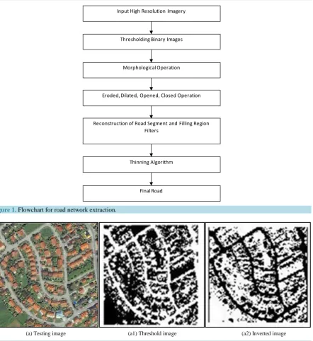
In this paper, a novel method is presented to detect the urban road network in high-resolution satellite images i.e. IKONOS and QuickBird. The proposed method is based on four main steps. Firstly, automatic thresholding is employed to segment roads from the color image to binary. This technique is shown similar concept used by [16] [17] presented global thresholding to segment roads from cropped image. Secondly, the morphological operation procedure is applied in the segmented inverted binary image, such as dilation, erosion, opening, and closing techniques are performed to highlight the road network and remove the undesired objects [18]. The third, steps are to use some filters, for example, reconstruction of lines segment to connect road network and link roads segment to each other and apply region filling method to remove the small redundant in the binary image. Fi-nally, post-processing procedures are used, such as thinning algorithm develop by [19] to extract the urban cen-terline of the road. Figure 1 shows a complete procedure of urban road network stepwise.
2.1. Extraction of Urban Road Networks
Extraction of the urban road network is an important process in remote sensing satellite field. The first step of the proposed method is the segmentation approaches are used to extract the roads from the high-resolution im-ages such, as IKONOS and QuickBird. To do this experimentally, three approaches automatic thresholding, morphological operations and finally, post-processing method are employed on satellite images. In the past lite-rature review, the researcher has used Canny edge detector and Sobel techniques for detection of edges, however, the result is not according to the desire results and have some limitation to road extraction. The excellent result is obtained using automatic thresholding approaches and afterward morphological operations, post-processing techniques are applied to extract the centerline of urban roads. Before applying the segmentation approach, a re-gion of interest is selected from the testing IKONOS and QuickBird images, where, urban roads are more prominent. The region of interest is a part of testing images, which could be sub-image of rectangular shape with the size of 2.95 × 3.28. The intended algorithms provide excellent result in the whole experiments [20].
2.2. Automatic Thresholding Approach Based on Urban Road Detection
Reconstruction of Road Segment and Filling Region Filters
Eroded, Dilated, Opened, Closed Operation Morphological Operation Thresholding Binary Images
Thinning Algorithm
[image:4.595.98.541.78.561.2]Final Road Input High Resolution Imagery
Figure 1. Flowchart for road network extraction.
(a) Testing image (a1) Threshold image (a2) Inverted image
Figure 2. QuickBird result by automatic thresholding.
also reported in the resultant binary images. This misclassification is due to the shadow of trees, buildings and vehicles on the road which have similar spectral color with roads. In order to extract the desired result, the out-put binary images are converted into inverted images sees Figure 2(a2) and Figure 3(b2). In this case, the road network is represented in black color to assumed highest intensity pixel value, whilst, the background is the white color with minimum intensity values, with some similar spectral objects is also reported.
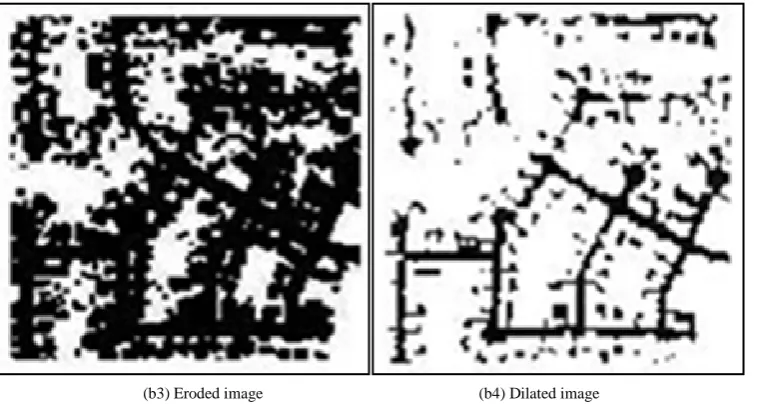
2.3. Urban Roads Extraction Using Morphological Operation Approach
In order to figure out the misclassification objects and remove the redundant features from the images, some morphological operation is used in the segmented threshold inverted binary images such as eroded, dilated, opened and closed techniques sees Figure 4 and Figure 5. During morphological opened procedure Figure 4(a3)
(b) Testing image (b1) Threshold image (b2) Inverted image
Figure 3. IKONOS result by automatic thresholding.
[image:5.595.128.501.275.475.2](a3) Opened image (a4) Closed image
Figure 4. QuickBird result by morphological operation.
(b3) Eroded image (b4) Dilated image
[image:5.595.127.507.504.706.2]which is not capable of extracting the roads network correctly, While in the case of closed operation excellently detect the roads network with small undesired features. This is due to the open grassy field, building material and car which have similar spectral features with roads. In Figure 5(b3) in IKONOS image the road network is detected perfectly with a small spur which is not our demand, whilst, the dilated binary image detected roads networks correctly with some non-linear objects and disconnection of roads segments can be observed in Figure 5(b4), this disconnection of road segment is due to the shadow of trees along the roadside and car on the road may occlude the road network. Morphological operations are based on mathematical morphology, which used for elimination and classifies part of the image based on algebraic non-linear operators. This complete process is employed on the segmented inverted binary image see Figure 2(a2) and Figure 3(b2). To reduce the effect of detection of the shadow of trees, car on road and remove nonlinear features some filter are used in the experiment such as roads segment reconstruction to link the road segment which is occluded due to trees shadow and region filling techniques are applied to eliminate the undesired feature having similar spectral objects with roads.
2.4. Post-Processing Procedures
The post-processing procedures are a close connection with filtering, for example, lines or segments reconstruc-tion, region filling and thinning algorithm of roads centerlines extraction.
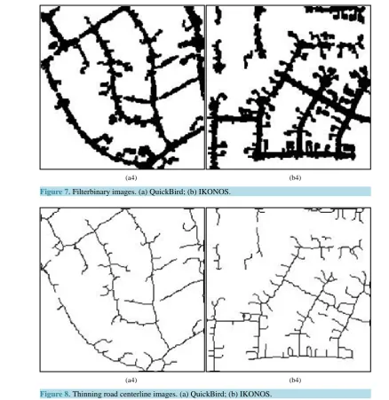
The scene of the satellite remote sensing images are used in this experiment are complex, the extracted ob-jects are corrupted by other obob-jects. For example, the shape of the road can be affected by vehicles, shadow of trees and buildings on the roads. In addition, some non-road objects having similar color features with road can also are misclassified is the roads see Figure 6(a4), Figure 6(b4). It can be observed some disconnection of road segments in the experimental result. In order to finish this problem of misclassification, shadow of trees and other similar spectral object to extract roads network correctly, some filtering procedure is necessary to end this issues. For this purposes segment, reconstruction and region filling techniques are used to eliminate the ef-fect brought by cars, shadow of trees and building shown in Figure 7(a4), Figure 7(b4), region filling is used to clear off the misclassified non-road features having non-linear shapes.
Finally, the thinning algorithm procedure is carried out by [19] to extract the centerline of the road. The road centerlines are accurately detected illustrated in Figure 8.
3. Results and Discussion
Binary segmentation methods have been used to extract the urban road from the high-resolution satellite image. To extracts the efficient results in the image, automatic thresholding approach is applied on the color IKONOS and QuickBird images to convert them to binary images, road and background segments. Several problems are examined to compute the appropriate threshold value, for example, the different pavement material used on the
(a4) (b4)
(a4) (b4)
Figure 7. Filterbinary images. (a) QuickBird; (b) IKONOS.
[image:7.595.124.502.301.525.2](a4) (b4)
Figure 8. Thinning road centerline images. (a) QuickBird; (b) IKONOS.
Finally, the thinning algorithm is carried out to extract the centerline of the road, this thinning algorithm used by [19] illustrated practical result in Figure 8. In which the QuickBird (a4) is better result than IKONOS (b4) is due to the complexity of the scene.
4. Conclusions
The proposed method of combining automatic thresholding and morphological operations is used to extract the road network from high-resolution satellite imagery. The significance of this approach is to introduce combining techniques of automatic thresholding followed by the morphological operation are implemented. Extraction of road segmentation has been performed with the help of automatic thresholding, which classified the color image to binary images such as road and non-road objects. The intensity pixel value of road is higher than the back-ground. In order to extract the desired result, the segmented binary image is converting to invert the image, in which the road is shown in black color and background with white color. Then, by employed morphological op-eration on the segmented image, the proposed method is tested on high-resolution satellite imagery of the urban area. The experimental result points out potential use of proposed procedure in extracting the road network from high-resolution satellite images in an efficient way.
In some part of the images, small area of barren land, vegetation covered area, open grassy fields and build-ings area is classified as roads. Filtering techniques are used to remove the unwanted features such as region filling techniques. Finally, post-processing procedure is employed for instances thinning algorithm by [19] to extract the urban road centerline correctly and analyzed with the result of [13]. In future to cope and solve the problem of extraction of non-road segments in an urban area to improve this automate techniques, some soft computing techniques are required.
Acknowledgements
The authors would like to acknowledge the support they have received by Liaoning Province University Innova-tion Team Program (LT2015013).
References
[1] Baltsavias, E., Gruen, A. and van Gool, L. (2001) Automatic Extraction of Man-Made Objects from Aerial and Space Images (III). Balkema, Lisse, The Netherlands.
[2] de Castro, F.S.P. and Centeno, J.A.S. (2010) Road Extraction from ALOS Images Using Mathematical Morphology.
IAPRS Journal, 38, Part 7B.
[3] Sirmacek, B. and Unsalan, C. (2010) Road Network Extraction Using Edge Detection and Spatial Voting. International Conference on Pattern Recognition, Istanbul, 23-26 August 2010, 3113-3116. http://dx.doi.org/10.1109/icpr.2010.762
[4] Yang, J. and Wang, R. (2007) Classified Road Detection from Satellite Images Based on Perceptual Organization. In-ternational Journal of Remote Sensing, 28, 4653-4669. http://dx.doi.org/10.1080/01431160701250382
[5] Li, L.-W., Liu, J.-P. and Yin, Z.-W. (2005) Road Extraction from High Resolution Remote Sensing Image Based on Mathematic Morphology. Remote Sensing Information, 5, 9-11.
[6] Daryal, N. and Kumar, V. (2010) Linear Extraction of Satellite Imageries Using Mathematical Morphology. Interna-tional Journal of Computer Applications, 3. http://dx.doi.org/10.5120/717-1009
[7] Baumgartner, A., Steger, C., Mayer, H. and Eckstein, W. (1997) Multi-Resolution, Semantic Objects, and Context for Road Extraction. In Semantic Modeling for the Acquisition of Topographic Information from Images and Maps, Birk-hauser Verlag, 140-156.
[8] Unsalan, C. and Boyer, K. (2005) A System to Detect Houses and Residential Street Networks in Multispectral Satel-lite Images. Computer Vision and Image Understanding, 98, 432-461. http://dx.doi.org/10.1016/j.cviu.2004.10.006
[9] Kim, Y., Seo, B. and Oh, J. (2000) The Effect of the Resolution of Satellite Images on the Interpretability and Detecta-bility of Geographic Information. Proceedings of Pecora 14-Land Satellite Information in the Next Decade, III Confe-rence, Denver Colorado, 6-9 December 2000.
[10] Coulter, L., Stow, D., Kiracofe, B., Langevin, C., Chen, D., Daeschner, S., Service, D. and Kaiser, J. (1999) Deriving Current Land-Use Information for Metropolitan Transportation Planning through Integration of Remotely Sensed Data and GIS. Photogrammetric Engineering and Remote Sensing, 65, 1293-1300.
http://dx.doi.org/10.1016/S0924-2716(02)00045-X
[12] Jin, H. and Feng, Y. (2010) Towards an Automatic Road Lane Marks Extraction Based on Isodata Segmentation and Shadow Detection from Large-Scale Aerial Images.
[13] Doucette, P., Agouris, P. and Stefanidis, A. (2004) Automated Road Extraction from High Resolution Multispectral Imagery. Photogrammetric Engineering & Remote Sensing, 70, 1405-1416.
http://dx.doi.org/10.14358/PERS.70.12.1405
[14] Jin, X. and Davis, C.H. (2005) An Integrated System for Automatic Road Mapping from High-Resolution Multi-Spec- tral Satellite Imagery by Information Fusion. Information Fusion, 6, 257-273.
http://dx.doi.org/10.1016/j.inffus.2004.06.003
[15] Valero, S., et al. (2010) Advanced Directional Mathematical Morphology for the Detection of the Road Network in Very High Resolution Remote Sensing Images. Pattern Recognition Letters, 31, 1120-1127.
http://dx.doi.org/10.1016/j.patrec.2009.12.018
[16] Goodman, J. (1997) Global Thresholding and Multiple-Pass Parsing. Proceedings of the 2nd Conference on Empirical Methods in Natural Language Processing,Providence, 1-2 August 1997, 11-25.
[17] Singh, P.P. and Garg, R.D. (2013) Automatic Road Extraction from High Resolution Satellite Image Using Adaptive Global Thresholding and Morphological Operations. Journal of the Indian Society of Remote Sensing, 41, 631-640.
http://dx.doi.org/10.1007/s12524-012-0241-4
[18] Li, L.-W., Liu, J.-P. and Yin, Z.-W. (2005) Road Extraction from High Resolution Remote Sensing Image Based on Mathematic Morphology. Remote Sensing Information, 5, 9-11.
[19] Zhang, T.Y. and Suen, C.Y. (1984) A Fats Parallel Algorithm for Thinning Digital 568 Patterns. Communications of the ACM, 27, 236-239.http://dx.doi.org/10.1145/357994.358023
[20] Benediktsson, J.A. (2003) Classification and Feature Extraction for Remote Sensing Images from Urban Areas Based on Morphological Transformations. IEEE Transactions on Geoscience and Remote Sensing, 41, 1940-1949.
http://dx.doi.org/10.1109/TGRS.2003.814625
[21] Ma, H., Qin, Q., Du, S., Wang, L. and Jin, C. (2007) Road Extraction from ETM Panchromatic Image Based on Dua-ledge Following. IEEE International Geoscience and Remote Sensing Symposium, Barcelona, 23-28 July 2007, 460- 463.
[22] Bacher, U. and Mayer, H. (2005) Automatic Road Extraction from Multispectral High Resolution Satellite Images.
Object Extraction for 3D City Models, Road Databases and Traffic Monitoring, 36, 29-34.
Submit or recommend next manuscript to SCIRP and we will provide best service for you:
Accepting pre-submission inquiries through Email, Facebook, LinkedIn, Twitter, etc. A wide selection of journals (inclusive of 9 subjects, more than 200 journals) Providing 24-hour high-quality service
User-friendly online submission system Fair and swift peer-review system
Efficient typesetting and proofreading procedure
Display of the result of downloads and visits, as well as the number of cited articles Maximum dissemination of your research work