© 2018, IRJET | Impact Factor value: 6.171 | ISO 9001:2008 Certified Journal | Page 4353
Automatic Floods Alerting System using GSM & PC
Karthikeyan .K
1, Mrs. K.P. Jamunalaksmi
21
P. G Scholar /Department of Electronics and Communication Engineering, Adithya Institute of Technology,
Coimbatore, Tamilnadu, India.
2
AssistantProfessor/Department of Electronics and Communication Engineering,
Adithya Institute of Technology, Coimbatore, Tamilnadu, India.
---***---
Abstract:
The purpose of a flood warning service is to detect and forecast threatening flood events so that the public can be alerted in advance and can undertake appropriate responses to minimise the impact of the event. This is a particularly important technology in developing countries, where flooding results in massive loss of life and property. Flood warnings are a highly important adaptive measure where protection through large scale, hard defences, is not desirable or possible. This may be the case if defences would cause adverse environmental or social problems, or where the cost of defence construction would be prohibitive. The project is to provide the sensors automatic Flood alerting system. Monitoring of water level, rain flow checking and Water flow velocity by the sensors. River water level and rain flow and water velocity status is monitored by the sensors and transfer to GSM and Computer. For easy surveying and with less delay the information can be send to the authority. To avoid flood based accident and to safeguard the people.Keywords
-Arduino AT 2560, Sensors, Speaker, LCD,GSM, Personal computer.
I. INTRODUCTION
Nowadays Several types of natural disasters, it is known that flood is one of the most dangerous since they have enough destructive power to change the course of rivers, sweep away and destroy whatever is in their path. Our motivation for this work is based on all damages caused in our region due to floods, this natural disaster has caused many people to suffer damage to their homes and losing their belongings.. Torrential rain pounded the region giving rise to widespread flooding by several rivers burst their banks. There exists encouragement for researching preliminary solutions in this kind of disaster to mitigate and help in rescue operations. A variety of options there is for creating systems capable of warning vulnerable populations about an imminent threat of floods. The fact that the data collection of levels of water bodies is executed by a person and it carries dangers and delays in the dissemination of information. One of these risks is endangering the person who comes to take action, as torrential rains access to the measuring points are extremely complicated, and in cases of Possible flooding these delays are crucial to salvaging belongings and especially the lives of people living in areas at risk.
Because of the expensive cost of gauges to measure water level and the importance of developing warning systems for measuring levels in rivers that contribute to safeguard lives of citizens who inhabit regions in danger of flooding, this project present a water level sensor based on water conductivity.
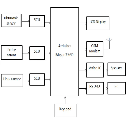
[image:1.595.312.561.300.535.2]II. BLOCK DIAGRAM
Fig.1. Automatic Flood Alerting System using GSM & PC
© 2018, IRJET | Impact Factor value: 6.171 | ISO 9001:2008 Certified Journal | Page 4354
III. RELATED STUDY
A. Arduino AT 2560 Architecture
Project is used to the Arduino mega 2560 because arduino is heart of the device. All the sub devices connected across it. This flash type reprogrammable and some peripheral devices to play this project perform.ATMEGA 2560 have 54 digital pin output and input. 16 bins used to analog input and 14 pins used to output purpose It provides sufficient power to all the peripheral devices. Power need not give individually to all devices. All the devices also activates as low power operation mode The Arduino Software contains a text editor for writing code, a message area, a text console, a toolbar with buttons for common functions and a series of menus. It connects to the Arduino and Genuine hardware to upload programs and communicate with them. Programs written using Arduino Software are called sketches. These sketches are written in the text editor and are saved with the file extension. The editor has features for cutting, pasting, searching and replacing text. The message area gives feedback while saving and exporting and displays errors. The console displays text output by the Arduino Software, and complete error messages and other information. The bottom right-hand corner of the window displays the configured board and serial port. The toolbar buttons is used to allow verifying and uploading programs, creating, opening, and saving sketches, and opening the serial monitor. this project is implemented with Arduino mega 2560 microcontroller using GSM module .The arduino mega 2560 has different types of facilities for communication and microcontroller.
B. GSM (Global System for Mobile Communications)
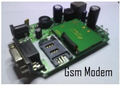
[image:2.595.336.530.78.218.2]The GSM which is one of the representative wireless. GSM is the most popular standard for mobile telephony systems in the world. its improve industry status and reached all over world of mobile phone carriers and manufacturers, estimates that 95% of the global mobile market uses the standard GSM is used by over 1.5 billion people across more than 200 countries and territories. Its enables international roaming arrangements between mobile network operators, providing subscribers the use of their phones in many parts of the world. GSM differs from its predecessor technologies in that both signalling and speech channels are digital, and thus GSM is considered a second generation (2G, 3G, 4G) mobile phone system. This also facilitates the wide-spread implementation of data communication applications into the system. A GSM modem is used to interface that allows applications such as SMS to send and receive messages over the modem interface. This project is used GSM module for intimate to water level status using sensor and microcontroller the mobile operator charges for this message sending and receiving as if it was performed directly on a mobile phone. To perform these tasks, a GSM modem must support an “extended AT command set” for sending/receiving SMS messages.
Fig.2 GSM Modem
C.Sensors
This project is used three sensor ultrosonic sensor,probe sensor and flow sensor. Sensor is the most important of create project.Sensors are sense the water density,speed of water and level of water.
Sensor is communicate to microcontroller and display the result and safegaurd of the people.
IV. HARDWARE RESOURCES
A. Arduino AT 2560 Microcontroller:
The Arduino Mega 2560 is a microcontroller board based on the ATmega2560. It has 54 digital input/output pins (of which 14 can be used as PWM outputs),16 analog inputs, 4 UARTs (hardware serial ports), a 16 MHz crystal oscillator, a USB connection, a power jack, an ICSP header, and a reset button. It contains everything needed to support the microcontroller; simply connect it to a computer with a USB cable or power it with a AC-to-DC adapter or battery to get started. The Mega is compatible with most shields designed for the Arduino Duemilanove or Diecimila.
B. Power Supply:
© 2018, IRJET | Impact Factor value: 6.171 | ISO 9001:2008 Certified Journal | Page 4355
C. Ultrasonic Sensor:
The Ultrasonic Water Level Sensor uses the latest ultrasonic distance measuring technology for accurate non-contact water level monitoring. ... The 125 cm ultrasonic water level sensor ranges are best for measuring river, lake and tank levels and for measuring open channel flow in larger flumes. Ultrasonic Water Level Sensor uses the latest ultrasonic distance measuring technology for accurate non-contact water level monitoring. The ultrasonic water level sensors contain a rugged transducer in stainless steel sealed housing for long life and provide an industry standard 4-20 mA output. The 125cm an ultrasonic water level sensor ranges are best for measuring river, lake and tank levels and for measuring open channel flow in larger flumes. Ultrasonic water level sensor installation is simple and requires no programming or calibration.
D. Probe Sensor:
Probe sensor is a switching device that gets activated by Water density. The Probe sensor detects water that completes the circuits on its sensor boards' printed leads. The sensor board acts as a variable resistor that will change from 100k ohms when wet to 2M ohms when dry. In short, the wetter the board, more current will be conducted. The Probe sensor detects the velocity of rainfall.
E. Flow Sensor:
Flow Sensor is used to find out velocity of Water Flow. Flow Sensor is working based on speed of inside the fan. The fan is rotate based on flow of water. this paper is used flow sensor calculated speed of Water level. This sensor is reach maximum level of the speed at the time of automatically decrease the value of Ultrasonic sensor because water level is reached is up normal level.
F. LCD:
Liquid crystal displays have materials which combine the properties of both liquids and crystals. Rather than having a melting point, they have a temperature range within which the molecules are almost as mobile as they would be in a liquid, but are grouped together in an ordered form similar to a crystal.An LCD consists of two glass panels, with the liquid crystal material sand witched in between them. The inner surface of the glass plates are coated with transparent electrodes which define the character, symbols or patterns to be displayed polymeric layers are present in between the electrodes and the liquid crystal, which makes the liquid crystal molecules to maintain a defined orientation angle. LCDs are lightweight with only a few millimetres thickness. it is working less power, they are compatible with low power electronic circuits, and can be powered for long durations. The power supply should be of +5V, with maximum allowable transients of
10mv.The LCDs used exclusively in watches, calculators and measuring instruments are the simple seven-segment displays, having a limited amount of numeric data. The recent advances in technology have resulted in better legibility, more information displaying capability and a wider temperature range. The LCDs have even started replacing the cathode ray tubes (CRTs) used for the display of text and graphics, and also in small TV applications. LCD module is used this project display the sensors result like water velocity, density and water level. The module should be isolated from the other circuits, so that stray voltages are not induced, which could cause a flickering display.
G. Speaker:
Speaker is used to announce the status of the flood in water Board department. Water level status announced stage by stage. Water of normal in river at the time Speaker will announce “The river stage is rising”. Water will be continues rising at the time Speaker announce “The river water level is continues rising” Water will reached in high position at the time of speaker announce “The river stage reached the highest level –Imminent Flood EVACUATION.
H. RS232:
In communications, RS-232 is a standard for serial binary data interconnection between Data terminal equipment and a Data Circuit-terminating Equipment. It is commonly used in computer serial ports. This is used to communicate the message to personal computer.
I. Keypad:
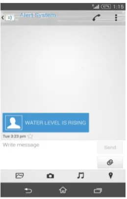
Keypad is used to enter the particular mobile number. Which mobile number is entered using keypad and send the message to particulate mobile number water status”water level is rising”
V. RESULT
1. PROBE SENSOR RESULT
© 2018, IRJET | Impact Factor value: 6.171 | ISO 9001:2008 Certified Journal | Page 4356
Fig 3. Probe Sensor Status Result
2. FLOW SENSOR RESULT
Flow Sensor is used to find out velocity of Water Flow. Whenever flow of water speed is high at the time send the message to authorised mobile number, announce to Water level is rising through speaker and Computer display Message of water level status. This sensor is reach maximum level of the speed at the time of automatically decrease the value of Ultrasonic sensor (Decreased value is represent Water level high level).
2.1 PC Display
2.2.LCD Display
2.3.Mobile Display
3. ULTRASONIC SENSOR RESULT:
Ultrasonic sensor is used to measure Water level. Probe sensor and Flow sensor are reached high at the time Ultra sensor to below value because water level was high and send the display the value of Ultrasonic and flow sensor in the pc and LCD Display.
3.1. PC Display
© 2018, IRJET | Impact Factor value: 6.171 | ISO 9001:2008 Certified Journal | Page 4357
3.3.Mobile Display
VI. CONCLUSION
The application of urban flood alert system using GSM which is based on arduino and sensors of things technology provides comprehensive monitoring and pays more attention to the management flooding prevention. It also provides operational services, conducts the monitoring and realizes the comprehensive supervision management, early warning management, and investigation management, which has not only improved the flood control decision making and drainage, but the city’s flood control capacity is significantly improved. It will contribute to the security of society and harmonious development and construction.
VII. REFERENCE
[1] M. Castillo-Effen, D. H. Quintela, R. Jordan, W. Westhoff, and W. Moreno, “Wireless sensor networks for flash-flood alerting,” in Proceedings of the Fifth IEEE International Caracas Conference on Devices, Circuits and Systems. IEEE, Nov 2004, pp. 142–146.
[2] R. Chowdhury, “Consensus seasonal flood forecasts and warning response system (FFWRS): an alternate for nonstructural flood management in Bangladesh,” Environmental Management, vol. 35, pp. 716–725,May 27 2005.
[3] F. Hossain, N. Katiyar, Y. Hong, and A. Wolf, “The emerging role of satellite rainfall data in improving the hydro-political situation of flood monitoring in the under-developed regions of the world,” Journal of Natural Hazards, vol. 43, pp. 199–210, March 9 2007.
[4] S. Saha and M. Matsumoto, “A Framework for Data Collection and Wireless Sensor Network Protocol for Disaster Management,” in Proceedings of the Second
International Conference on Communication System software and Middleware (COMSWARE 2007) Bangalore, India. IEEE, January 2007, pp. 7–12 .
[5] R. Fantacci, M. Vanneschi, C. Bertolli, G. Mencagli, and D. Tarchi, “Next generation grids and wireless communication networks: towards a novel integrated approach,” Wirel. Common. Mob. Comput., vol. 9, no. 4, pp. 445–467, 2009.
[6] X. Yang, M. Ke, Y. Chen, H. Li, J. Liu, and T. Yang, “Water level measuring network design and implementation,” in Information Engineering and Computer Science (ICIECS), 2010 2nd International Conference on, Dec 2010, pp. 1–4.
[7] W. Kang and Y. Shibata, “Performance Evaluation of Disaster Information System Based on P2P network,” in Advanced Information Networking and Applications Workshops (WAINA), 2010 IEEE 24th International Conference on, 20-23 2010, pp. 710 –715
[8] U.S. De, G. P. Singh and D. M. Rase, Urban flooding in recent decades in four mega cities of India, J. Ind. Geophys. Union, April 2013,Vol.17, No.2, pp. 153-165.
[9] Xue, X.G., Jiang, S.F., Li, M., et al.(2016) Application Trend of GIS in Urban Drai-nage and Flooding Prevention. Science & Technology Vision, No. 1, 71-72.
[10] Tong, L.G. (2015) Urban Drainage and Flooding Prevention Intelligent Controlling Platform Based on Internet of Things and GIS. Science & Technology Information,13, 10-12.
[11] N. Raman than, L. Bolzano, D. Estrin, M. Hansen, T. Harmon, J. Jay,W. Kaiser, and G. Sukhatme, “Designing wireless sensor networks as a shared resource for sustainable development,” in ICTD ’06: Proceedings of the International Conference on Information and Communication Technologies and Development, May 2006, pp. 256–265.
[12] Youliang Chen and Zhaoru Wang, Implementation of a Long-Distance Monitor and Automatic Alarm System of Flood Disaster in PoYang Lake Area, 2008 International Symposium on Information Science and Engineering, pp. 120-123.
[13].Guy Schumann, Renaud Hostache, Christian Puech, Lucien Hoffmann, Patrick Matgen, Florian Pappenberger, and Laurent Pfister, High-Resolution 3-D Flood Information From Radar Imagery for Flood Hazard Management, IEEE Transactions on Geoscience and Remote Sensing, VOL. 45, NO. 6, June 2007, pp. 1715-1725.
© 2018, IRJET | Impact Factor value: 6.171 | ISO 9001:2008 Certified Journal | Page 4358 from:n<http://www.urbanflood.eu/Pages/Publications.
aspx> [Accessed 2 March 2013].
[15] Mioc,D,et Al.”Early warning and mapping for Flood Disaster”. The international archives of the photogrammetry, remote sensing and spatial information sciences.Vol.XXXVII.PartB4.Beijing 2008, pp.1507-1512.
[16] R. Chowdhury, “Consensus seasonal flood forecasts and warning response system (FFWRS): an alternate for non-structural flood management in Bangladesh,” Environmental Management, vol. 35, pp. 716–725, May 27 2005.
[17] F. Hossain, N. Katiyar, Y. Hong, and A. Wolf, “The emerging role of satellite rainfall data in improving the hydro-political situation of flood monitoring in the under-developed regions of the world,” Journal of Natural Hazards, vol. 43, pp. 199–210, March 9 2007.
[18] M. Castillo-Effen, D. H. Quintela, R. Jordan, W. Westhoff, and W. Moreno, “Wireless sensor networks for flash-flood alerting,” in Proceedings of the Fifth IEEE International Caracas Conference on Devices, Circuits and Systems. IEEE, Nov 2004, pp. 142–146.
[19] ALERT Systems Organization, “Alert history,” http://www.alertsystems.org.
[20] T. M. Hopson and P. J. Webster, “Operational short-term flood forecasting for Bangaldesh: pplication of ECMWF ensemble precipitation forecasts,” vol. 8, 2006.
[21] M. Castillo-Effen, D. H. Quintela, R. Jordan, W. Westhoff, and W. Moreno, “Wireless sensor networks for flash-flood alerting,” in Proceedings of the Fifth IEEE International Caracas Conference on Devices, Circuits and Systems. IEEE, Nov 2004, pp. 142–146.
BIOGRAPHIES
I am K.Karthikeyan,I am pursuing M.E applied electronics at Adithya institute of Technology ,Coimbatore. I completed my B.E degree in Electronics and communication engineering from Government College of technology, Coimbatore. My areas of interest are Embedded System and Wireless Communication System.