1
Abstract
The cliffs above the public beaches of the Conero Riviera between Ancona and
Portonovo, Italy, are comprised of sedimentary rocks and are subject to copious rainfall and
occasional earthquakes. The area has experienced large-scale landslide events, from Portonovo’s
14th century landslide to Ancona’s more recent 1982 landslide. Though these events have been
studied at length, there are no studies on this region’s risk of future landslides. Based on the
historical and geological evidence, it is important that the Ancona coastline be assessed for
landslide risk. This study aimed to determine the role of geologic structures in the area near these
two historic landslides using kinematic analysis as well as structural and stratigraphic field data
collected between the Ancona shipyard and the southernmost accessible beach of Monte Conero.
We collected data from within several different rock units and observed distinct patterns of
jointing, faulting, and bedding along the coast. Some of these structures show risk of planar and
wedge failure. There is evidence of recent rockfalls and landslides, all of which were smaller
than the two historical slides. We conclude that the Conero Riviera coastline is at risk for future
landsliding and rockfall, making it dangerous for beachgoers.
Introduction
The cliffs above many public beaches in and around Ancona, Italy, show clear signs of
landslides and landslide risk yet. The area of study, the Conero Riviera spanning from Ancona’s
shipyard to Monte Conero is located in a region with a strong history of earthquakes, heavy
2
The area just north of this field site underwent a massive landslide in 1982 (Crescenti et
al, 2005). This event occurred along 1.7 km of the coast, affecting a total of approximately 3.4
km2 of the land (Crescenti et al, 2005). The sediments affected by this slide were mid-Pliocene
marly clays interbedded with silts and sands, all overlain by Pleistocene silty/marly clays with
stratified sand layers (Crescenti et al, 2005). Also, in Portonovo, Italy, just south of Ancona,
there was another massive slide in the early 14th century (Montanari et al, 2016). This slide was
characterized by the movement of five million cubic meters of the Scaglia Rossa, Marne a
Fucoidi, and Maiolica limestone units from up to 400 meters elevation (Montanari et al, 2016).
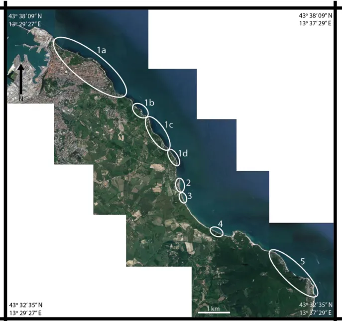
The lithology of the region is primarily limestone with a small stretch of alternating
gypsums and marls (Figure 2). The coast was split into eight analysis regions based on bedrock
composition and the orientations of structures (Figure 3). For sections 1a-d, the cliffs are
comprised of the Miocene units of Bisciaro limestone overlain with Schlier limestone. The
weathering for 1a-c, which is characterized by the formation of friable clumps of rock from silt
sized up to cobble sized, pervades up to 10 cm back from the face of the outcrop into the rock.
The weathering affects the Bisciaro unit uniformly. The Schlier is comprised of beds of
alternating strength, so it weathers differentially with ~0.75 m difference between the layers that
are ½ m thick(Figure 4). In section 1d, the jointing is dense, and this section is transforming into
a C horizon soil rather than weathering away from the outside in as seen in section 1a-c. South of
the Schlier/Bisciaro units in section 2, the cliffs are comprised of Colombacci marls, another
Miocene unit. The weathering of this unit is uniform and is similar to the weathering at 1d, also
creating a C horizon soil. The Gessoso-Solfifera unit, section 3, consists alternating beds of
Miocene gypsum and marly shales. Some of the beds contain microcrystalline chalk laminae.
3
jutting out of the base of the cliff. Further south in section 4, closer to Portonovo, the Schlier and
Bisciaro outcrop again. The fifth and final segment of this analysis is Monte Conero. This region
is mostly Maiolica limestone (lower Cretaceous) with a small outcrop of Scaglia Rossa limestone
(late Cretaceous-middle Eocene) and chert beds at the northernmost end of this section.
Weathering in these units was superficial rather than pervasive, consisting primarily of slight
surface discoloration.
In the region of study, there are clear indications of frequent small-scale landsliding such
as fallen boulders and gravel, fresh detachment faces, and piles of fallen soil and debris. Thus,
this area is a prime location for studying landslide risk. Further, while the regions of past large
slides have been studied, no research has been done to determine if the Riviera is at risk for a
massive sliding event comparable to the two mentioned above. This study aimed to discern the
magnitude and nature of the landsliding risk of the region in an effort to predict futures slide
locations and styles.
To this end, we explored the idea that structural data can be used to determine whether a
particular stretch of coast within the field area is at risk of landslides. In addition to structural
effects, the effects of stratigraphy on risk magnitude was also examined. Historical slides and
rock falls were used to characterize the style of landsliding that the area is at risk of. Standard
slope analyses and the characteristics of the rock units were used in resolving the question of
how structurally sound each section of coastline is. Structural and stratigraphic analysis was
chosen for this project because the field area is highly populated with structures such as joints,
bedding, faults, and stylolites.
4
Fieldwork was conducted from June 24-July 21, 2016. The process began with the
examination of Google Earth maps, bedrock maps, and historical aerial photography obtained
from Ancona’s cartographic office. From this imagery, we determined the location of slides that
occurred in recent history, paths to be able to access these locations, and the extent of the field
area. The study area spanned from 379946.39 m E, 4831392.06 m N to 389104.68 m E,
4822365.39 m N (Figure 3). The data collection process consisted of working along the base of
this stretch of cliffs, covering as much of the coast as could be reached by foot. We accessed two
beaches and several photographic vantage points by boat.
Using a Brunton compass, we obtained and recorded slope, joint, bedding, fault,
slickenside, and stylolite measurements. These measurements were analyzed on stereonets using
the program Stereonet3D. The density of the fractures and stylolites as well as the depth to which
weathering affected the different rock units were also recorded. Whenever evidence of past
landsliding was present (such as fallen debris or detachment scarps), the nature of the slide
(rockfall versus landslide), dimensions, and detachment location of each slide was noted. Since
many of the slides detached from too far up the cliffs to see from the vantage point of the beach
and since many of them happened over the course of many years, Google Earth historical images
were used to assist in this process where field data was insufficient. At each new rock unit, hand
samples of the bedrock were taken for future reference. The European Marine Observation and
Data Network (EMODnet) was used to obtain bathymetry data (http://www.emodnet.eu/).
Wyllie and Mah’s kinematics analysis served as the basis for determining the risk of rock
failure (Wylie et al, 2004). This process gives criteria for determining three different types of
5
failure, wedge failure, and topple failure (Wylie et al, 2004). The criteria for determining these
failure depend on the slip envelope of the rock; for this analysis, we used a slip angle of 30
degrees. Tables 1 and 2 contain all the criteria for each form of failure.
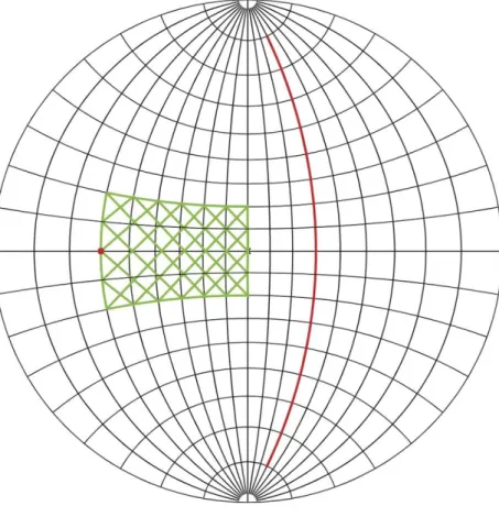
Planar failure can occur when the following conditions are met: (1) the dip direction of
the planar feature in question is within 20 degrees of the dip direction of the slope face and (2)
the dip angle of the feature is greater than the slip envelope but less than the slope-face dip angle
(Wylie et al, 2004). Both of these conditions are met when the feature is oriented such that its
pole falls in the shaded region in Figure 5. The steeper the dip of the plane, the greater the risk of
failure (Wylie et al, 2004).
The next form of failure is wedge failure (Wylie et al, 2004). This form of failure deals
with the stability of wedges of rock formed from the intersection of two planes of weakness
(Wylie et al, 2004). In this case, the orientation of this intersection line is considered instead of
poles to the planes (Wylie et al, 2004). If (1) the plunge of this line falls between the slip
envelope and the slope’s dip angle and (2) the trend of this line is within 20 degrees of the
slope’s dip direction, the wedge is at risk of falling (Wylie et al, 2004). The region that the line
must fall within to meet these criteria can be seen shaded in Figure 6. The steeper the intersection
line, the higher the risk of failure (Wylie et al, 2004).
Topple failure occurs when steeply dipping planes of weakness cause entire columns or
sheets of rock to topple over. For this type of failure, (1) the dip direction of the plane must be
within 10 degrees of that of the slope face, and (2) the sum of the slip envelope and the
complement of the dip angle must be less than the dip angle of the slope face (Wylie et al, 2004).
6
Results
The mean orientations and density of structures for all locations can be seen in Table 3.
Six out of the eight regions are at risk of both planar and wedge failure, and one is at risk of
planar failure alone. In total, seven out of eight regions exhibit risk of kinematic failure induced
landsliding or rockfall. Figures 8a-8m show each region’s form(s) of failure and which structural
feature is forming the failure planes.
Section 1a and 1b
These areas had two sets of pervasive joints. Several instances of block falls caused by
the two joint families were found (Figure 9, Figure 10). Two types of past landsliding can be
seen in this area: falls of large boulders and cobbles from various heights on the cliff and low
volume landslides of sand to cobble sized clasts.
Section 1c
This section was characterized by a lack of homogeneity in jointing. We found a higher
concentration of faults here than elsewhere in the Schlier/Bisciaro. The landsliding in this area
was largely small landslides with few large blocks falling.
Section 1d
The jointing pattern becomes similar to the intersecting joints pattern seen in 1a, but with
much greater fracture density. There was also a landslide which detached from approximately
100 m elevation on the cliff face. This slide was comprised of a mud matrix with some limestone
7
appeared to be recent since it contained undecomposed plant matter and since it had not yet been
compacted.
Section 2
There were two more landslides similar in style to the one at 1d, though smaller and less
recent. They were roughly 50 and 75 meters wide at the toe. There are two families of joints
which are oriented for wedge failure. Section 2 is also similar to section 1 in that the joint
spacing is narrow.
Section 3
This section’s planar features are bedding and three faults. None of these features are
oriented in a way that is suitable for any type of failure. The bedrock is only visible at the bottom
of the cliffs as the top is covered by debris.
Section 4
While the bedrock is the same as section 1, the bedding orientation changes. The jointing
lacks clustering. They dip between 50-90 degrees. The jointing is oriented such that this area is
prone to plane, wedge, and topple failures. We found large planar failure blocks that had
detached that were similar to the ones at 1a. There were also several small slides. Like section 3,
the bedrock only outcrops at the bottom of the cliff due to the top being covered in debris.
Section 5
The bedding here is oriented for plane failure. Tens of square meters of bedding planes
8
of the joints and stylolites are oriented for wedge failure. The remains of two large landslides
were present.
Discussion
Relative landslide risk levels
Based on the number of failure types at each location, locations 1a-d, 4, and 5 are the
highest landslide risk regions as they show both planar and wedge failure risk. Within locations
1a-d, 1a and 1d are at higher risk levels than 1b and 1c because a larger total proportion of their
joints are oriented for failure than the joints in 1b-c. Locations 2 is at moderate risk level with
planar failure risk of its joints. Location 3 has no structures oriented for kinematic failure.
Relative landslide risk can be seen in Figure 11.
To further differentiate locations by their relative risk level, additional factors such as
landsliding history, weathering patterns, cliff heights, and the density of planes of weakness
should be considered. Based on additional factors, locations 3 and 5 appear to be at higher risk
than the kinematic analysis alone can indicate.
Implications of past slides
North of location 5 at Portonovo, there was a historic massive landslide in the early 14th
century (Montanari et al, 2016). This slide originated from a much greater height than the slides
in sections 1-4 (maximum of 400 m height in Portonovo versus maximum of 85 m in this
region), but at a similar height to location 5. It also affected similar limestone rock units rock
units (Scaglia Rossa, Marne a Fucoidi, and Maiolica), and location 5 is comprised of Scaglia
9
Monte Conero (360-530 m in the region analyzed) combined with its similar composition, its
clustering of failure planes, its cleavage, and its close proximity to the 14th century slide are
cause for added concern. There are also other detachment scars that appear to be from large
planar failures. Thus, section 5 appears to be a larger risk than the kinematic analysis can
illustrate alone and should be further inspected using additional analysis that incorporate more
than kinematics.
The area just north of the total study area underwent a massive landsliding event in 1982.
This slide started at the toe of the slope that failed and worked its way farther inland to fail in one
massive slump of land. This is not congruent with the characteristics of slides seen in this field
area, which are characterized by relatively small amounts of the cliff crumbling away at a time
without directly causing other areas farther inland to slide as well. The bathymetry of the region
also does not lend itself to allowing this sort of failure. The slope of the seafloor east of the cliffs
out into the sea is too shallow to permit it. The seafloor slopes just under 20° on average based
on the EMODnet bathymetric maps, making the rock under the cliffs a low risk zone for
underwater slides because this slope is too shallow for structures to form many failure planes.
Instead, only the subaerial units of the steep cliffs are prone to failure. Ultimately, it is unlikely a
landslide similar to the 1982 slide would occur in this region.
Future slides
The style of landsliding at locations 1a-c is similar despite these locations having
different orientations of joints. The weathering style of the Schlier layer, which leaves every
other bed jutting out of the cliff without support, plays a part in the gravel to boulder sized rock
10
layers erode away, larger and larger volumes of the strong layers are left jutting out of the cliff
side with no underlying support. These areas are prone to rockfall events from any height up the
cliffs.
Location 1d and 2 have been more weathered than 1a-c and are partially weathered to C
horizon soils. Still, they are each populated by two distinct families of joints. The joints are
spaced 8-30 cm apart in section 1d and 10-30 cm apart in section 2. The past slides seen in this
area are soil slides rather than rockfalls. Further analysis into how far this soil pervades inland is
needed before we can estimate the volume of futures slides at 1d and 2, but future failure should
be expected to be landslides rather than rock falls.
Locations 3 is the only location without risk of kinematic failure. The slope above the
outcrop, however, is covered in old landslide deposits. It is likely that non-kinematic factors are
causing these slides, and this stretch needs further investigation before its risk level can be
completely understood.
The landslide that partially covers location 3 also covers the upper part of location 4.
While location 4 has planes oriented for both wedge and planar failure, these features are only
exposed near the bottom of the cliff. They are not seen further up on the cliff. The current
landslide deposit would have to be eroded away entirely to reveal a fresh cliff face before wedge
or planar failure could occur from the top of the cliff. The nature of slides in the immediate
future will be rockfalls from less than 15m height.
Location 5 shows risk of planar failure along bedding planes. There are detachment scars
11
(Figure 12). While this region is at risk of both planar and wedge failure, the majority of failure
planes are oriented for planar failure. Almost all of the bedding planes are oriented for planar
failure, while only about one third of the joints and stylolites are oriented for wedge failure.
Thus, a planar failure slide is more likely to occur here than a wedge failure slide. This area is
susceptible to cobble to boulder sized pieces of rock as well as large sheets of bedding
plane-failing from high elevation. Since the cliffs here are much higher than anywhere else in the study
area, location 5 could produce a slide of a much larger volume of rock than the other locations
exhibiting two failure types.
Conclusions
Of the eight sub-regions of study, all except one show an elevated risk for landslides. The
two most hazardous regions are the coast along the northeast edge of the city of Ancona and the
coast at the base of Monte Conero. The shoreline near Ancona is the most crowded of all the
beaches in the region of study. There is a high risk of large blocks falling in this area due to
planar and wedge failure created by joint planes. These blocks could seriously injure people on
the beach. Until preventative measures to stabilize the area are taken, beachgoers should avoid
these cliffs. Monte Conero is the region at risk of the largest volume and highest energy landslide
in the area due to the high elevation. The dense concentration of bedding planes oriented for
planar failure along with the wedge-failure-forming joints and stylolites make Monte Conero
unstable. These factors combined could create a high-volume slide similar to the 14th-century
Portonovo slide. Overall, this entire region is unstable due to orientations of joints, stylolites, and
12
Bibliography
Crescenti, U., M. Calista, M. Mangifesta, and N. Sciarra. Giornale Di Geologia Applicata 1 (2005) 53 –62, Doi: 10.1474/GGA.2005-01.0-06.0006 The Ancona Landslide of December 1982 53.62 (2005): 53-62. Associazione Italiana Di Geologia Applicata E Ambientale. 2005. Web. 3 Dec. 2016.
Montanari, Alessandro, Maurizio Mainiero, Rodolfo Coccioni, and Gaia Pignocchi.
"Catastrophic landslide of medieval Portonovo (Ancona, Italy)." Geological Society of America Bulletin. N.p., 2 June 2016. Web. 4 June 2016.
Montanari, Alessandro, Maurizio Mainiero, and Rodolfo Coccioni. "The Little Big History of Medieval Porto Novo and Its Landslide."Osservatorio Geologico Coldigioco (2015): n. pag. Print.
Regione Marche - Territorio E Ambiente. CARTA GEOLOGICA REGIONALE 1:10.000. DotNetNuke Corporation, 2010. Web. 24 Apr. 2017.
13
Figures and Tables
15
16
17
18
19
20
Variable Definition
𝜓 Slip envelope
𝛼𝑠 Dip direction of the slope face
𝛼𝑝 Dip direction of the plane
𝜃𝑠 Dip angle of the slope face
𝜃𝑝 Dip angle of the plane
𝛽𝑙 Trend of line of intersection of two planes
𝜇𝑙 Plunge of line of intersection of two planes Table 1: Variables for kinematic analysis equations
Planar Failure
𝛼𝑠− 20 ≤ 𝛼𝑝 ≤ 𝛼𝑠+ 20
𝜓 ≤ 𝜃𝑝 ≤ 𝜃𝑠
Wedge Failure
𝛼𝑠− 20 ≤ 𝛽𝑙 ≤ 𝛼𝑠+ 20
𝜓 ≤ 𝜇𝑙≤ 𝜃𝑠
Topple Failure
𝛼𝑠− 10 ≤ 𝛼𝑝 ≤ 𝛼𝑠+ 10
90 − 𝜃𝑝+ 𝜓 ≤ 𝜃𝑠
Table 2: Equations of the criteria for different forms of failure.
Location Unit(s) Bedding Joints
(a)
Joints (b)
Joints (c)
Joint density (m)
Slope Cliff height (m)
1a Schlier/
Bisciaro
21
1b Schlier/
Bisciaro
127/28 015/85 269/69 330/76 304/71 50-110
1c Schlier/
Bisciaro
127/28 337/61 80-170
1d Schlier/
Bisciaro
127/28 303/63 198/86 0.08-0.3 326/54
180-210
2 Colombacci 112/40 359/78 269/68 0.1-0.3 340/60
150-160
3 Gessoso-
Solfifera
108/66 and 285/32
340/60 130-150
4 Schlier/
Bisciaro
093/40 265/90 90-120
5 Scaglia
Rossa/ Maiolica
318/53 313/53
360-530
Table 3: Mean structural data for structures that formed families
22 Figure 8c Figure 8d
23 Figure 8g
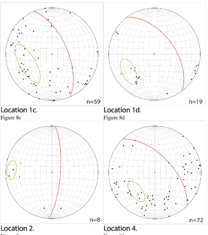
Figure 8a-8f Planar failure analysis for locations 1a-d, 2, 4, and 5. Poles to structures (black), poles to cliff face (red) and average cliff face (red plane) for each location. Structures oriented for failure are circled in green. The failure planes in Figure 8f are bedding. All other planar failure planes are joints.
24
Figure 8j Figure 8k
Figure 8l Figure 8m
25
26
27
28
29
Appendix: Structural Data
Key
b bedding
j joints
s slope
ps pressure solution
f fault without sense of motion
nf normal fault
tf thrust fault
sf sinistral fault
df dextral fault
Stop Structure Strike Dip Rake
1 b 75 43
80 38
49 18
86 40
95 49
2 b 75 62
70 48
72 52
j 195 42
128 88
3 b 62 49
60 52
j 181 68
174 60
169 52
184 54
194 54
4 b 266 79
262 79
258 75
256 73
j 148 87
5 82
30
164 84
165 69
165 71
5 j 148 89
240 50
250 51
244 55
304 43
171 87
6 b 264 74
244 70
260 71
261 71
7 j 9 66
324 57
338 90
6
landslide
face 260 90
270 90
j 252 89
328 90
8 j 174 54
284 73
181 68
276 42
276 58
205 61
255 72
274 48
233 43
b 94 40 *
94 72 *
9 b 112 40
111 28
115 48
114 35
102 32
110 55
104 50
31
286 48
284 63
171 90
200 82
207 90
220 82
338 74
286 44
308 50
40 78
11 j 150 62
245 79
250 64
b 145 30
10 j 343 76
284 85
152 74
58 70
204 75
236 70
12 b 110 36
101 40
97 25
113 27
105 28
j 323 62
290 68
346 74
301 66
341 49
318 60
175 84
270 60
344 58
281 52
301 55
253 60
251 70
32
14 b 120 61
105 80
111 68
93 48
105 70
109 58
286 58
285 61
285 61
284 70
15 TF 285 10
16 j 321 58
372 65
224 72
228 82
335 54
221 80
335 66
282 52
214 79
222 79
339 68
225 78
282 49
333 60
270 65
b 114 38
105 35
123 35
116 35
135 32
17 b 126 26
18 b 135 20
119 24
19 b 115 37
129 31
20 j 24 88
218 86
33
30 80
21 s 328 87
304 60
b 112 18
130 40
135 33
j 20 85
205 89
306 4
314 78
320 60
260 70
334 61
288 58
29 80
323 65
22 b 120 31
j 333 81
314 86
274 85
299 82
256 73
254 62
17 68
321 55
283 90
s 280 60
291 62
23 s 126 73
b 149 24
j 11 71
354 87
233 65
173 70
27 85
257 89
353 90
235 82
34
349 70
280 64
270 69
291 61
81 90
288 55
39 77
291 50
41 82
287 65
296 55
68 88
255 75
311 49
288 58
60 88
291 52
25 s 132 65
b 150 22
j 205 85
336 75
286 69
252 78
285 58
271 67
27 nf 128 58
29 b 298 47
30 b 103 34
j 4 73
256 69
355 82
282 68
31 j 193 48
155 90
32 f 190 40
33 b 142 16
j 8 90
318 45
35
234 44
34 s 297 68
346 58
300 55
j 303 75
260 51
1 65
279 74
15 89
284 72
35 j 335 47
197 86
36 s 267 68
b 114 30
j 316 68
277 71
280 71
251 79
1 75
285 60
37 b 125 14
j 22 80
284 75
318 80
295 79
271 79
181 90
257 85
288 89
254 82
26 84
301 89
291 87
201 90
284 81
10 85
269 82
38 b 171 18
36
j 189 79
215 89
294 78
269 75
38 88
184 86
355 68
16 86
197 82
290 66
9 87
24 90
255 64
5 87
39 s 312 87
295 56
j 324 65
332 77
352 79
338 86
278 78
324 75
258 61
40 b 144 12
j 297 65
221 89
12 33
327 52
274 48
41 s 340 55
b 149 15
157 14
164 22
132 30
j 89 51
300 89
227 72
264 72
37
51 88
326 58
274 57
358 51
35 68
47 72
276 32
257 71
81 90
217 85
317 60
267 90
42 s 6 68
305 66
b 154 13
147 25
j 16 76
13 78
292 78
12 80
331 58
11 50
301 64
43 nf 219 35 15E
nf 229 28 22E
nf 58 73 27E
b 155 33
j 330 63
27 72
286 90
268 90
44 df 310 55 0
j 32 89
114 87
210 84
32 72
82 81
177 88
38
45 nf 189 70 20N
j 36 78
51 53
244 67
84 64
46 s 338 64
b 134 32
140 32
47 s 315 60
b 119 18
j 319 71
247 28
20 65
343 58
245 81
49 b 116 31
117 32
j 344 25
200 79
223 86
331 70
214 44
nf 127 74 55E
nf 110 59 84W
sf 347 31 14S
50 s 325 43
b 137 34
j 30 85
303 61
329 50
252 79
205 89
51 s 220 47
b 115 39
119 31
j 304 50
309 53
304 53
39
214 87
53 s 330 73
b 114 40
j 194 88
301 64
202 85
29 80
304 62
61 s 10 47
b 15 69
26 69
j 274 47
271 59
290 47
272 56
265 57
north b 347 77
356 55
350 66
351 71
62 b 350 32
350 74
344 32
341 32
358 36
357 36
270 78
j 163 42
40 80
25 90
87 86
tf 158 45
f 86 90 21E
f 217 70 20E
63 tf 54 64
b 337 42
320 22
303 19
40
335 28
ps 120 57
87 84
162 80
180 75
178 74
260 85
64 b 323 41
322 46
ps 81 70
190 51
277 77
146 67
236 85
184 45
74 86
65 b 314 67
ps 247 85
224 90
222 85
210 55
16 87
78 58
69 63
157 85
63 73
345 67
220 85
231 48
61 45
66 b 314 52
309 32
306 43
j 204 49
57 66
175 52
60 61
256 85
41
59 74
229 81
ps 113 55
108 90
28 45
111 57
279 6
115 63
108 90
271 63
6 53
355 53
67 b 333 27
312 34
317 22
323 54
326 58
j 174 82
183 72
110 67
174 82
ps 52 86
74 58
60 82
47 90
70 87
18 62
s 110 80
68 b 310 43
328 64
320 56
322 58
325 53
j 114 37
80 87
30 66
86 83
155 72
42
170 77
ps 74 88
174 60
76 65
76 58
192 39
262 76
245 45
47 65
186 77
315 86
70 75
84 84
290 79
69 b 325 48
318 42
327 55
329 45
325 50
j 150 28
319 47
84 79
10 73
108 66
165 66
70 85
181 30
219 81
237 60
ps 41 50
211 59
36 69
32 69
32 68
220 77
335 57
145 45
72 77
43
219 66
95 25
221 69
79 87
81 81
82 81
255 83
183 60
s 305 41
70 FA 54 35 50W
45 43 45W
70 27 61W
70 30 70W
102 39 88W
101 40 84W
FB 292 87
292 90
FC 100 86 29W
JA 246 82
40 84
BA 291 41
304 44
JB 61 68
29 86
BB 285 35
b 248 62
348 60
71 b 337 65
72 b 334 82
336 73
337 7
350 66
8 56
s 320 68
j 82 79
310 82
283 62
94 72
44
217 90
205 84
205 88
210 84
210 84
74 J 193 82
218 85
62 86
224 74
210 77
214 80
302 60
294 74
209 84
214 82
219 87
215 81
214 83
214 85
294 50
276 56
214 83
200 84
303 58
202 78
201 86
210 86
327 65
187 75
214 86
310 51
220 89
313 72
204 89
274 61
200 79
160 65
195 72
45
125 20
s 280 54
j 204 85
212 68
222 77
220 84
216 86
216 79
325 55
219 74
220 79
214 74
229 73
335 71
227 80
295 46
217 80
314 54
220 86
313 56
220 72
315 61
221 76
315 52
221 80
315 60
236 71
76 j 220 80
280 78
320 61
224 80
292 45
219 83
324 60
224 80
276 54
219 81
275 57
46
220 80
291 45
221 81
314 58
293 45
225 73
322 61
284 55
256 59
228 72
330 51
228 78
225 78
230 70
226 77
320 56
224 79
329 63
226 76
269 53
281 42
b 115 32
110 31
110 32
77 b 115 40
127 38
j 150 88
189 89
280 53
157 82
360 71
330 57
295 46
172 39
27 90
310 53
19 83
343 50
47
78 b 131 26
129 37
j 20 87
300 36
232 80
327 60
30 87
296 53
204 90
323 87
291 68
315 53
287 58
290 55
26 55
315 56
296 57
8 90
290 51
351 70
325 59
303 57
316 57
296 39
300 40
321 57
245 44
235 40
322 60
210 36
319 56
324 64
30 58
284 52
305 53
346 68
310 56
200 87
48
322 56
314 51
34 69
236 56
79 j 334 53
323 55
233 56
310 56
214 70
325 58
2 70
295 38
291 52
287 42
201 79
302 41
277 38
313 55
208 89
294 36
329 55
309 41
25 72
280 50
297 45
30 90
80 b 116 33
119 31
s 304 53
j 324 62
193 85
6 74
322 51
300 40
336 40
10 80
294 45
18 87
49
308 57
282 44
226 71
294 71
304 42
5 83
81 b 119 29
s 286 55
j 295 40
45 86
259 58
294 54
82 b 116 33
j 326 61
38 87
332 63
303 63
32 72
330 60