Visual
Value
Robin
Corathers
44AH
toooftenin thiscountrywe
thinkwe
havetwo
/V
choices....tobuy
landand
lockitup
foreverinapark or a preserve, or to let anything-goes, horrible,
schlocky
development
occurrightnextdoor.Those
arenottheonlychoices
we
havein thiscountry.There
isa thirdchoice,and
thatiswe
canhavegrowth
and
devel-opment
that respects the characterof a placeand
re-spects
and enhances
thecharacterofourlandscape."[Edward
T.McMahon,
director,American Greenways
Program,
The
ConservationFund
November
25,1991atThe
Hillside Trust's "Hillside Protection Strategies"conferenceinCincinnati, Ohio.]
The
Greater Cincinnati metropolitanarea insouth-west
Ohio
and
northernKentucky
is graced withan
extraordinarynetworkofriversand greenhillsidesformed thousands ofyears
ago
bythreedifferent glaciers.The
forestedhillsides
and
theriversystemsgivetheregion auniquevisualpersonality
and
contributesignificantlyto thearea's qualityoflife.This hillsidesystem providesaesthetic,
economic and
environmental benefits totheurban region.
The
ribbons of greenopen
space offer spectacularviewsand
opportunitiesforoutdoor
recrea-tionwithinan urbansetting.Realestatevaluesforareaswith views, or adjacent to or near unspoiled slopes,
remain
high.The
hillsides are an integral part of theurban ecosystem, providingwildlifehabitat
and
migra-RobinCorathersisexecutivedirectorof TheHillsideTntst.She
served asprojectmanager
for the Tnist's research projectsand
editoroftheproject publication 'A Hillside Protection StrategyforGreaterCincinnati.'She
previouslyworked
asan
environmental plannerfortheOhio-Ken-tucky-IndianaRegionalCouncil of Governments.
Thisarticleisbasedinpart
on The
Hillside Trust's publi-cationprincipallyauthoredbySamuel
V.Noe,an
architectand
professorintheSchool ofPlanningatthe UniversityofCincinnati.
Noe
isaboardmember
ofThe
Hillside Trust.tioncorridorsaswell asrelief
from
airpollutioncaused byurban
congestion.The
forestedslopes prevent soilerosion
and
floodingand
help conserveenergybyshad-ing buildings in
summer
and
blocking cold winds in winter.The
hillsides are also quitefragile; GreaterCincin-natiis
known
foritscostly landslides.U.S. GeologicalSurveystudiesindicatethe costsoflandslide
damage
to privatepropertyand
public infrastructureinthe Cincin-nati area are in the millions ofdollars annually.The
geological historyoftheregion hasresultedin
an
abun-dance
ofsteep valley slopes, consistingofglacialclaysand
till,atopbedrock
formations containing high per-centages ofshale.Many
hillsides,particularlyalongtheOhio
River, arenotyetinastateofgeologicalequilib-rium, a condition geologists call
"immature
topogra-phy."
These
factors,together withahigh averageannualrainfall,contribute to thearea's
many
landslides.But
ithas
been
insensitivedevelopment—
cutting intothe toesofslopes, placingfill
on
slopes, regradingand
paving without controlleddrainage-which
has triggered the vastmajorityoflandslides.Inadditiontolandslide
damage,
insensitivedevelop-ment
and poor
designhavechanged
thevisualcharacterof the hillsides
and
destroyed valuable natural areas. Until about fifteen years ago, the region's hillslopesremained
largelyundeveloped, withmost
constructionoccurringinvalley
bottoms
and
on
hilltops. Inthe pastdecade, however,
development
pressures foreven the steepest slopes have sharply increaseddue
to several factorsincludinggrowing
scarcity ofundeveloped
flatland; technological advances in earth
movement
andretentionmethods;
and
the increasingnumber
of peoplewho
want and
canafford propertieswithaview.About
fifteenyears ago, thecityofCincinnati"Environmental
Quality(EQ)
Hill-sideDistricts,"azoningoverlaywithinwhich
protectivemeasures
could beestablished.
To
date only halfofthe hillsides in the city havebeen
desig-natedas
EQ
HillsideDistricts,and
inmost
oftheregiontheneed
for hillside protection has notbeen
addressedatall.
Two
factorshavelimited theadop-tionofrational
and
well-coordinatedpolicies
and enforcement
ofstringent regulationsbylocalgovernments.Many
government
officialsintheregionhave supported unlimitedgrowth
and
have beenreluctanttoantagonizedevelop-ers
who
they believewould oppose
hillsideprotectionmeasures.
The
lackof information about the "environ-mental
and
visualsensitivity"ofhill-sideswithin the variouspolitical juris-dictions located in the Greater
Cin-cinnati metropolitan region has fur-ther
hampered
protectionefforts.In 1988, the Hillside Trust, a private nonprofit re-gional landconservation organization,
began
research to provide better information about the hillsidesand
better tools forboth its internal decision-making
and
that oflocal
governments and
othersconcerned
withhillside
development and
preservation.The
Trustfor-mulated thefollowingresearchquestions:
•
How
should therelativeaestheticqualitiesand
envi-ronmental
significanceofhillsides in themetropoli-tanarea beassessed?
•
How
canthese distinctionsberelatedtovulnerabilitytolandslides
and development?
•
What
areappropriateguidelinesand
regulationsforcases
where
sensitive hillsidedevelopment
is pos-sible?•
Which
hillsideareasdeservepriorityattentionbytheHillsideTrust
and
localgovernments?
The
HillsideTrustrecognized thatacomprehensive
approach
to hillside protectionwas needed
to guidesound
decision-making.The
Trust's staffand
consult-antsdesignedtwo
research projects:one documenting
the relative sensitivity ofhillside land
and
identifyingcriticalnaturalareasforpriorityattention;
and
asecondcreatinga
model
setofhillsidedevelopment
guidelinesandregulationsforadoption bylocalgovernment.
The
HillsideTrustproposed
to studythe impact ofdevelopment
type,density,design,and
locationfactorson
perceptions ofvisualqualityand
how
toincorporateAsthisviewformPriceHillillustrates,Cincinati's hillsidescombinewith theOhioRivertoformanatural
visualamenity. '
this information into planning guidelines, goals
and
objectives.
The
Trustcontactedthe U.S.ForestService fortechnicaland
financialassistance. Itwas
referred to the ForestService'sNorth
Central ForestExperiment
StationinChicago,Illinois,
which
had
done
researchon
visualpreferences
and
visualresourceassessmentmeth-odology.
The
Forest Servicehad
developed a VisualManagement
System
for evaluating wilderness areas,butthis
methodology had
neverbeen
adaptedtourban
environments nor incorporatedintoageographic
infor-mation
system (GIS). Previous research by theNorth
Central office in Cincinnati
had
shown
that intense hillsidedevelopment
can negativelyaffectperceptions ofvisual quality.The
ForestServiceexpressedinterest in thisproposaland
agreed to fund it through cooperative research grants. In addition to the Forest Service funding, the HillsideTrustwas
able tosecurefinancialand
in-kind servicesupportforthetwo
studiesfrom
elevenstateand
local
government
agenciesand
private foundations,and
from
scores ofindividual professionalsand
interested citizenswho
volunteeredtheirexpertiseand
time.Although
the geographic scope of the Trust'sre-searchis limited to the Greater Cincinnati region, its
work
shouldbe ofinterest toelectedofficials,planningand
zoningcommissioners
and
staff,designand
devel-opment
professionals, park commissioners,civiclead-ers,
and
othersconcerned
with land conservationand
development
issues in hilly terrain. In particular, the design ofthe Hillside Trust's studiesand
thedevelop-ment
guidelines theygenerated can serve as a usefulenviron-mentally sensitivehillside land is subject to
develop-ment
pressures.GIS
Study
The
HillsideTrustdecidedtouseacomputer-based
geographic information system (GIS) toprovidea
flex-ible
and dynamic
techniqueforidentifyingcriticalhill-sideareas.
The
Trustwas
particularlyinterestedinusingGIS
to:• analyzepotentialimplicationsofalternativepatterns
of
development
and
planningstrategies;•
"zoom
in"on
specific siteswithinthe electronicmaps
and
conductmore
detailedstudies;• allow
government
plannerstoadjusttheparametersofthe analytical models,based
on
new
or differentenvironmental data ordifferentsetsofassumptions;
• rapidly update data
and produce
maps
at differentscales.
Although
the HillsideTrust isconcerned
with the protection ofhillsideresourcesina five-countyareainsouthwest
Ohio
and
northernKentucky, it limited itsGIS
study to hillsides inHamilton
County,Ohio
and
Kenton
County,Kentucky,an
areaencompassing
over370,500acres.This choice
was
made
because of budgetconstraints
and
because thesecounties had theirown
GIS
orareintheprocess ofestablishingone.Research
involved thedesignand
testingofsystem-atic
computer-based
models
formapping
hillsides.The
analyticalmodels
rate hillsides according to relative visualquality,landslidehazard,valueasecologicalcor-Exiaisivcgradingofhillsidesmakesthemsusceptibletolandslidesanderosion.
ridors,
and
susceptibilitytodevelopment.These
classi-fications
were
thencombined
toproduce
sixcolor-coded composite
maps
showing
therelative sensitivityofhillsidelandtodevelopment.
The
analyticmodels determined
the datarequire-ments
forthestudy.HillsideTruststaffcollectedexist-inginformation
from
a greatrange oforiginalmapping
scales
and
map
types.Landsatsatelliteimagerywas
usedto update land use/land cover information.
The
map
coordinate system selected
was
Universal TransverseMercator
(UTM).
ERDAS
GIS
softwarewas
chosenforuseindigitizing
map
informationinto theGIS
because ofitsefficiencyand
speed.This transformationprocesswas
closelymonitored
because ofinaccuraciesinsome
ofthe originalmaps.
The
TrusthiredDr.Douglas
Way,
alandscape archi-tectand
consultingprincipal oftheSWA
Group,
Co-lumbus,Ohio,todevelopthe analytical
models
incon-sultationwith the HillsideTruststaff
and
an advisorycommittee,
which
includedrepresentativesfrom
allthesupportingorganizations.Dr.
Way
produced
aseriesof primaryand
summary maps
ofhillside characteristics fortheproject.Analytical
Composite
Maps
VisualSensitivity.
An
analyticalmodel was
developedtodeterminetherelativevisual qualityofhillsidesas a function of land use/land cover, proximity to water, diversityofpositive landscape elements,
and
locationalongthehillsideupland
edge
(theareamost
criticalto visual impact.) Natural,undeveloped
areas that are close towater, withacombined
view offorests,water, agriculturallandorpastures,and
are locatedon
the sen-sitivehillsloperimwere
rated highestinvis-ualquality
and
sensitivity.Landslide Potential. Geological
infor-mation, degree ofslope,
and
evidence ofpreviouslandslides
were
usedtodeterminerelative landslide hazard. In the Greater Cincinnatiregion, landslides are
most
likely tooccur overthe Fairviewand
Kope
bed-rock formations,which
containup
to eightypercentshale.Slopeinstabilityisalso asso-ciatedwith areas located
above
lacustrineclays. Steepness of slope
and
proximityto existing areas of instability are the other primaryvariables indetermininglandslide susceptibility.Ecological Corridors.
While
studies inotherpartsofthecountry have
documented
the
importanceof
forestedareasin filtering particulatesfrom
theairand
absorbing andstoringcarbondioxide,in
moderating
tem-peratures,
and
in preventing erosion andwas
availablein the Cincinnatiarea. After conferringwithbiologists
and
other scientists,the Hillside Trustinstead decided to focus
on
the region's pattern ofecological corridors
which
sustain anabundance and
varietyofwildlife.
The
relativeimportance
of eachhillsideasan ecologi-calcorridorwas determined
byexamining
landcharac-teristics(upland, rim, slope,valley),proximitytowater, land use/land cover,and,
where documented,
thepres-ence of threatened
and endangered
species.The
most
ecologicallysignificant zonesare
found
in linear pat-terns followingthe valley systems,alongthelower edgesof the hillslopes, adjacent to or nearstreams,
and
inareasleastdisturbedbydevelopment.
Development
Susceptibility. Susceptibilitytodevelop-meni was determined
to bea function of proximity to existing orproposed
infrastructure, includingmajor
roads,water
and
sewerlines; construction costsdeter-mined
bytopographicslopeand
flood hazard;and
visualamenities includingviewpotential
from
hillsideedges andvalleyslopes.of the
"macro"
analysiswhilealsoincludingappropriate "micro"information.In this example, desirable land
was
defined as allundeveloped
parcels largerthanone
acre,rated as hav-ing highvisual sensitivityorhighqualityasanecological corridorand
rated as having a high susceptibility to landslides.To
thiswas added
more
detailedsiteinfor-mation
including analysisofsoiltypesand
their limita-tions for development; the quality of tree stands asevaluated bya U.S. Forest Servicelandscapearchitect
who
visitedand
mapped
thesites;and
informationon
zoning, land ownership,
mean
value of parcels,and
proximityto
major
roads.Development
Guidelines
The
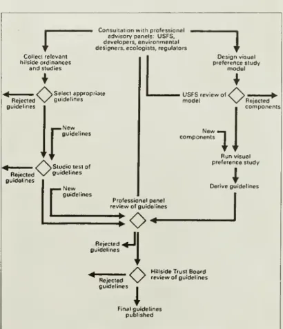
HillsideTrustusedseveralresearchmethods
toformulate appropriate guidelines for
development
insensitive hillsideareas (see figure1):
• survey
and
evaluation oflegislation in use bycitiesandcounties withsimilartopographicfeatures
through-out the
United
States;Summary Maps
Visual
and
Environmental Sensitivities.To
identifycritical hillsideareas, a
composite
map
was
generatedthat identifies hillsideswith highvisual sensitivity,high
quality ecological corridors,
and
highlandslide poten-tial. This analysis provides multiplejustifica-tionforprotectionofthese areasthrough
per-manent
preservationmethods and
through useof
more
stringent controls overany
futureproposed development.
HillsideAction Priorities.
As
an additionalplanningtool,the
summary
map
ofvisualand
environmentalsensitivities
was
overlaidon
themap
ofdevelopment
susceptibility to identifywhere
highquality sensitivehillsideareasare also susceptible to future development. This compositemap
locateshigherqualityhillsides thatareunder
lesspressureatthepresenttimefor
development and
may
therefore be lessexpensive to acquire, as well as hillsides of
relatively
low
visualand
environmentalsensi-tivity
where
itwould
be appropriatefor localgovernments
todirectfuturedevelopment.Detailed
Small Area
Analysis
To
demonstrate futureapplications of theGIS-generated data base for local planning
decisions, the HillsideTrust chosea "micro"
areaspanningthe
Ohio
Riverand
illustratedhow
a hypotheticalstudy could beconductedforparkland acquisition.
The
detailedmodel
illustrates the
change
in scalefrom
regional analysis to site-specificstudy,usingtheoutputconsultationwithenvironmental,development,
plan-ning
and
legal professionals;adaptationoftheU.S.ForestService's visual
prefer-encemethodology,focusing
on
anumber
ofdevelop-J"
Consultationwithprofessional .
advisorypanels: USFS,
developers,environmental designers, ecologists. regulators Collect relevant
hilsideordinances andstudies
1
^
Selectappropriate Rejected\s
guidelines guidelineslr
New
guidelines
O
Studiotestof guidelines guidelines[
New
guidelines
Designvisual preference study
model
iUSFSreview
model
4
New
components
ll
Runvisual preference study
\
Deriveguidelines Professionalpanel
reviewofguidelines
—
Rejected guidelines
Rejected guidelines
O
1
o
HillsideTrustBoard reviewof guidelinesFinalguidelines published
ment
variablesand
theirvisual impact inan
urban environment;• testingof packages ofguidelines in a Universityof
Cincinnatistudioof
advanced
architectureand
plan-ningstudents,supervisedbyrespecteddevelopersin the region.
GuidelinesDerived
from
ExistingOrdinances. Provi-sionsof ordinancesfrom
around
thecountrywere
clas-sifiedbytype, relativedegree of importance,and
typeoflegislative or policy vehicle in
which
they aremost
appropriatelyincluded.
The
guidelinesdetermined tobe
most
applicable toGreaterCincinnati arearange ofpublicpolicies;guidelinesforregulationofsubdivisions
ofhillsideland;zoningtoregulate densityofhillside
de-velopment; zoning to regulate the visual characterof
hillsidedevelopment; earthwork,erosion,drainage
and
sedimentationcontrols;
and
retentionand
replantingofvegetation.
GuidelinesDerived
from
the Visual Preference Study.Hilltophighr'tsedevelopment shouldbe reserved fora few promontorypoints subjecttorigorous design reviewtoensureproperhillcrestsetbacks.
The
HillsideTrustincorporatedpublicopinionintoitsresearch using a modified version ofthe U.S. Forest Service'svisualpreferencetechnique.
The
resultsofthe visualpreference study providean
additionalbasis forrecommending
where
green space shouldbe maintainedon
thehillsidesand where
differenttypesofbuildings relateharmoniously
withthe naturalenvironment.The
conclusions
drawn from
the visualpreference studyalso lendanadditionalmeasure
oflegitimacytotherecom-mended
guidelines,becausethe guidelinesembody
theviews of botha representative
sample
oflocalresidents aswellas professionalswhose
work
involvesdifferent aspectsofhillsidedevelopment
inthe region.The
TrusthiredJohn
Decker,an
architect,landscapearchitect,
and
professorattheSchool of Planningatthe University of Cincinnati, to designand
execute the visualpreferenceresearch.The
visualpreferenceratingtechniqueinvolved the creationofthirtyviews of char-acteristic hillsides,developedtodifferentdensitieswith
a varietyofbuildingtypes,
and
sited inarange of differ-ent patterns.Most
oftheviewswere
syntheti-callyconstructed,using a
computer
imaging proc-essingsystemto overlayphotographs
ofarange ofbuilding typeson
aphotograph
ofanundevel-oped
hillside.This permittedvirtuallyeverylikelypatternofhillside
development
inthe collectionofviews.
Lay and
professional research participantswere
askedtoindicate the extenttowhich
theyfound
eachimage
eitherattractiveor unattrac-tiveand,incasesofextreme
reactions,therea-sonsfor their feelings.
The
responseswere
thentabulated,
and
laterusedinthedevelopment
ofa
number
ofguidelines.After
examining
thethirty images, eachre-spondent was
askedtowork
withan operatorof thecomputer
imaging system to construct a preferredpatternofhillsidedevelopment.The
totalcollectionof"ideal"
development
patternson
thesame
hillsidewere
thensuperimposed
on
one
another in order to locate the portions of thehillsidesmost
oftenleftfreeofdevelopment
and
the locationsmost
commonly
favored for differenttypesofbuildings.The
Hillside "Studio": Testing Guidelines inthe Design Laboratory.
Midway
through the project, anumber
of promising approaches to regulation of hillsidedevelopment began
toemerge from
thepreliminaryanalysisoflegisla-tion inuse inotherpartsofthe country.
These
approaches
were
evaluatedand compared
inan urbandesign studio exerciseatthe University of Cincinnatitotesttheirappropriatenessto local conditions. In this exercise, four teams ofad-vanced
studentsfrom
theDepartment
of Archi-tectureand
theSchool of Planningwere
askedtodesignhousing
developments
on two
prototypicalCincinnatisites.
Two
ofthe teamswere
assigned aneight-acre mid-slope site in an inner
suburbanlocation.
They were
instructed todesignapproximately fifty dwellingunits,witheach
team
followinga differ-entpackageofdevelopmentregulations.The
othertwo teams were
assigned a hillcrest siteon
acommanding
ridgeoverlookingthe
Ohio
Riverand
down-town
Cincinnati.They
were
also given differentdevelopment
regulationsand
askedtodesign
between
fortyand one
hundreddwellingunits, ineithera
high-riseor a less obtrusive configuration.
Allteams
were
assigned a practicingresidentialprop-ertydeveloperasa
mentor and
designcritic.During
theexercise,thestudentswere
askedto evalu-atethesetofguidelinestheywere working
withand
to suggest revisionswhich
might contribute to designsmore
compatible with the hillside environment.The
design
work
continued basedon
these revisedguide-lines.
The
range ofarchitecturaldesignsproduced
in the studioproved useful in determining appropriate loca-tions fordifferent typesofbuildingson
thehillsides.The
testing of the different
development
guidelinesem-ployedprovedequallyhelpful.
Some
guidelineshad
the potential toplace unreasonableeconomic
burdenson
projectdevelopers. Others,whilepreventing
many
forms of inappropriate development, alsohad
the effect ofconstraining particularly imaginative
and
desirableapproachestodesign.Thisstudioexperienceinfluenced
finalchoicesfor
recommended
development
guidelines, primarilybyhelping to discardlesspromisingapproaches. Expert Consultation.Throughout
the course ofthisproject, the HillsideTrust consulted with a variety of
hillside
development
professionals,includingsoilscien-tists,geologists
and
geotechnical engineers, landscapearchitects, architects,
urban
designers,ecologists,biolo-gists,planningofficials,developers,
and
attorneys.These
experts assisted in the design of the study, participated inworkshops
on
development
guidelinesand
seminars basedon
the studiowork,served as sub-jectsinthevisualpreferencestudy,and
revieweddrafts of the Hillside Trust'sfinal report.Inall, 162guidelines
were
generatedfrom
thestudy.The
HillsideTrustbelievessome
ofthese guidelinesare essential toanylocalgovernment's hillsideprotectionprogram.
Of
particularnoteare the Trust'srecommen-dations for public policies that call fordesignation of
hillside protection overlay districts; establishment of
hillside
development
reviewboards; public acquisition offeesimpletitleor conservationeasements
forcriticalHousingdevelopmentappropriatetoamid-slopesitelocaledonaninnersuburbanhillside.Densityhasbeen kept
lowbyclusteringtheunits,leavingmuchoftheforestedhillsideuntouched.
hillsideareas;
and
requirementsthat publicand
quasi-publicagencies bebound
byhillsideprotectionmeas-uresinadditionto privateproperty owners.
Other
guide-linesarerecommended
oroptionaland
shouldbecon-sidered a
menu
from which
localgovernments
canpickand
choose,depending
on
theirown
needsand
uniquecircumstances.
Next
Steps
The
HillsideTrustannounced
thecompletion
ofitsresearch projects inJune, 1991,atitsannual
member-shipmeeting,
and
received favorablelocalpress cover-age.Sincethattime,theorganization hasbeen working
to familiarize elected officials, planning
and
zoningcommissions
and
staff,designand development
profes-sionals,and concerned
citizenswithitsfindingsand
rec-ommendations
throughpublicpresentationsand
meet-ings.
On
November
25, 1991,The
HillsideTrust heldaday-long public conference entitled "Hillside Protec-tion StrategiesforGreater Cincinnati"
which
175 pro-fessionaland
lay peoplefrom
Kentucky and
Ohio
at-tended.Speakers coveredtopicsfrom
specificlandcon-servation
methods
toregulatingthe qualityof designfor hillsidedevelopment.[Editor'snote:
A
full account ofprojectmethodologies, findingsand recommendations
can befound
inThe
Hill-side Trust'sthree-volumepublicationA
Hillside Protec-tionStrategy forGreaterCincinnati. Copies ofthethree-volume
setofbooks summarizing
The
HillsideTrust'sre-search are available for
$45
plus$5.50for shippingand
handling. Copies ofthe hillside developmentguidelinesdata baseare availableineither31/2"or
5
1/4"floppy disks for$25
plus $3 for shippingand
handling.For
more
informationabout
The
HillsideTrust'swork,writeorcall:The
HillsideTrust3012
SectionRoad
atFrench
ParkCincinnati,