Mobile Tracking Application for Locating
Friends using LBS
R.K.Nadesh,Assistant Professor;SITE
VIT University, Vellore - 632014, TN, India [email protected]
J.Jayashree, K.Nirupama, J.Vijayashree, K.Anish Fatima
P.G.Scholar; SITE; VIT University, Vellore – 632014, TN, India. [email protected], [email protected]
Abstract
Now-a-days Location based services are becoming more important to mobile users. LBS are the mobile service which uses the user location information which consists of X and Y coordinates generated by GPS which is a mostly used positioning technique. This paper presents a mobile location tracking application in a cellular mobile network based on Location based service that describes tracking system called mobile tracker using GPS as a location provider through the geographic positions of a mobile network. This implements a client server system that helps the users to locate their friends and receive alerts whenever they are nearby. It enables the user, basing on the radius around the mobile device defined by the administrator. MYSQL database is used to update the location information and track the location. Further enhancement can be done by increasing the radius capacity to communicate more deliberately.
Keywords: Location Based Service (LBS), Global Positioning System (GPS)
Introduction
Location based services are used more frequently by the mobile users. A location based service is a location provider that is used to track the location of any mobile node through the mobile network that includes vehicular tracking system called fleet net. In mobile communication the tracking of location plays a major role using this LBS services. In order to track the location of the user’s mobile device it checks the nearest base station available to the mobile network and GPS Global Positioning System for tracking location. The GPS satellite is used for navigation purpose and it is combined with LBS is used to track the location of mobile device and the actual work of GPS is to calculate the position in the measure of coordinates like latitude and longitude values through the GPS receiver. In general this GPS works in open space areas only and used for radio navigation purpose through radio signals the GPS is a small device that can be embedded in any devices like mobiles.
The mobile that is embedded with GPS receiver calculates the exact longitude, latitude and altitude values and those values can be used by LBS for finding the location.GPS also provides information like time for calculating sender and receiver locations based on the information received from the satellites. Using GPS receiver in the mobile device we can even set the navigation path from source to reach a particular destination .Three satellites may be enough for computing the position of mobile devices.
To make best usage of this application in real time scenario for diverting traffic jam we can make use of inter vehicular communication by sending notification messages about heavy traffic or accidents to the nearby vehicles and those vehicles will in turn forward the message to other vehicles nearby[8,9].
RelatedWorks
devices. The application makes use of a mobile phone or PDA which is provided with GPS receptor and GSM network. This application enables the user (a) to track a mobile device and send alerts messages to a predefined number via short message service (SMS) if the mobile device is not present in the specified radius or in an interest location radius (b) to send distressed calls to a predefined number via SMS by just pressing one key from the keypad (c) for detecting an unauthorized SIM card in the mobile phone and to send a warning message via SMS from the current GSM cell and GPS position. mTracker also maintains a record of the positions which are already monitored. This allows the users to check when and where the mobile device was located using Google maps. The application uses two user profiles the administrator and the user to be tracked. The administrator can only access the application settings by a login screen using a protected password.
Authors in [2] presents a mobile application based on providing Location Based Service using Global Positioning System (GPS) as a location provider is presented. The application is implemented as a client server system that helps users to locate their friends and receive alerts when friends are nearby. The application works in open space areas only since it relies on GPS by calculating the longitude and latitude values of the mobile. Future extensions may look at other options such as getting the location from the service provider. In this case the location accuracy will be reduced and will depend on the size of the cells where the user is located.
Authors in [3] in this paper presents mobile tracking algorithm during severe non-line-of-site and multipath propagation in cellular networks. The main purpose of this paper is to boost the accuracy of positioning system in cellular networks. Two methods are proposed to achieve this aim, a two-step position determination method and a one-step method. Here constrained optimization is used to minimize the cost function. Mobile velocity and heading angle information is used for improving the accuracy of the position. In the two-step position determination method, the position determination is performed as the first step by applying optimization technique with NLOS mitigation to produce initial position estimation. Mobile track geometry or motion direction information and mobile velocity are used to reduce the position errors. In one-step position determination method a position determination scheme is proposed which handles the two processes in one step.
Hybrid location estimation tracking of mobile devices can be done in two ways network-based and the satellite-based systems as presented by Authors in [4]. Both types of system have their advantages and limitations under different environments. In order to provide various scenarios for location estimation by using Time Difference-Of-Arrival (TDOA) and Angle of Difference-Of-Arrival (AOA) and Global Positioning Systems (GPSs) a hybrid location scheme, which combines both the satellite-based and the network based signals, is proposed in this paper. The Mobile station is connected to satellites that retrieve the information about coordinates using GPS and network base station tracks the location from server base station of location database. The proposed scheme utilizes the two-step Least Square method for estimating the three-dimensional position (i.e. the longitude, latitude, and altitude) of the mobile devices. The Kalman filtering technique is introduced to eliminate the measurement noises and to track the trajectories of the mobile devices. The simulation result shows the consistent location estimation accuracy under different environments.
Authors in [5] proposed a RBPF-PL (Rao-Blackwellized particle filtering and parameter Learning method) to track mobility in the mixed LOS/NLOS conditions, where the statistical parameter of NLOS error is unknown. In order to achieve the minimum weight conditional variance of importance weight and get more accurate estimation of sight condition, the optimal trial distribution is used. Then by applying decentralized Kalman filtering method, the mobile state could be analytically computed. In the parameter learning step, sight conditions are updated according to the measurement and the estimation and mobile state. Simulation results show that this method could achieve a good tracking performance and the NLOS parameters can be effectively inferred.
Authors in [6] have presented a comparison of some of the techniques used for mobile locating and tracking mobiles in a cellular network. The first technique is based on time of arrival methods which requires minimum three base stations. The second technique is based on angle of arrival which requires only two base stations. Providing accurate time estimations and angle of arrival is mostly degraded by multipath fading. It has highlighted the problem of multipath fading in providing accurate estimations of time and angle of arrival and it has compared the effect of location geometry on TOA and AOA in terms of their GDOP.
whichis a non-linear function of the position of a mobile. The purpose of Bayesian bootstrap filtering approach being used here is to cope with the nonlinearity. The author assumed that the mobile is mounted on a vehicle so that the mobiles movement is restricted in a road. Here the signal power measurements at several base stations are compared with the power maps at each position. Large errors may be there in the power maps or the measurement if the mobiles movement is not restricted to a particular road or area.
Proposed system
Mobile tracking facility is not available in the existing system which forces the user to specify the location details by him turns as the major drawback. The application facilitates mobile users in finding services available in specific location such as discovering the nearest restaurant or nearest hospital etc.
The applications of this type are restricted for the service providers of mobile devices. The reason for this is that they use mobile cells information for getting the mobile’s location. Mobile phone tracking tracks the current position of a mobile phone even on the move. To locate the phone it must emit at least the roaming signal to contact the next nearby antenna tower.
The main aim of this work is to design and implement a client server system that helps users to locate their friends and family members through mobile. It tracks the user location information using GPS and sends a message to the user about his location.
The user will be provided with an alert message about his friend’s location when his friend is within a couple of meters to the user. The user can be navigated to his destination dynamically using this application. It also helps the user when he is new to some place by knowing his location on the spot.
It reduces the task of searching the particular location manual search. Using GPS the user can know his present location coordinates and if the user moves to other location automatically the coordinates will update and changes the location information in user mobile device. Any type of user can use this application efficiently.
Methodology
The main objective of the proposed system is tracking location. The end user can find his friends location through this service. The location is tracked using GPS and display the coordinates. The User is independent in accessing the data. The main intention of this application is to help the user to reach his destination by finding locations through GPS. Any type of user can use this application efficiently without any risk factor. The location can be tracked based on the radius maintained by the administrator.
The client-side system is a MIDlet application which serves as an interface to feed in the contents and control instructions which is interpreted on the server and the appropriate action is taken. The MIDlet has the task of creating design page for Welcome Page, User Registration, User Login, Add Member, and Family/Friends Request.
Welcome page contains two fields that are IP Address and status of user. IP Address is used for connecting the server to the mobile client using Stream Socket Connection. For the connection the remote desktop IP address is given in the mobile and the desktop IP addresswill be stored temporarily. The status of user is used for determine the process future. If the user is new then he has to select the User Registration option or else he can select the User Login options.
Only the registered users can use this service. So the users should register his user name and password which will then be sent to the server. Once the user registered then he can login to the service by entering the username and password. User can also add any number of registered users to his list as a friend or friend member.
The server also gets user location coordinates and stores it in the database and then it calculates the distance between two mobile devices that is two friends or family members based on the coordinates information stored in the database and sends alert message if the friends are nearer to each other.
In order to update the user location in server, the mobile request the location of the user from GPS. The GPS determines the longitude and latitude and sends the information to the mobile phone. Therefore in order to build a location based application we need java MID2.0 enabled and JSR 179 compliant mobile phone. The mobile phone should have a built-in GPS unit.
Results and Discussion:
Many people expect new type of applications developed with J2ME. The application categories would remain the same, except for a few exceptions such as location services and data applications that integrate with telephony functionality. The outcome is likely to be applications that are context sensitive (immediacy, location, personal or professional use) and are migrating from a character-based interface (browser-based applications) to a graphical environment, providing developers and end users with an unmatched level of flexibility.
As far as adoption of J2ME, the prognostics are rather good. Evans Data recently conducted a survey among 500 wireless application developers, concluding that more developers will use Java and J2ME to develop wireless applications (30%) than native C APIs (Palm OS, Pocket PC, EPOC) or even WAP.
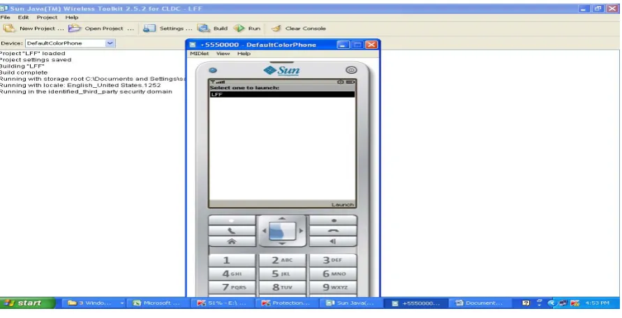
Fig. 1. Application screen
Fig. 2. Entering IP Address
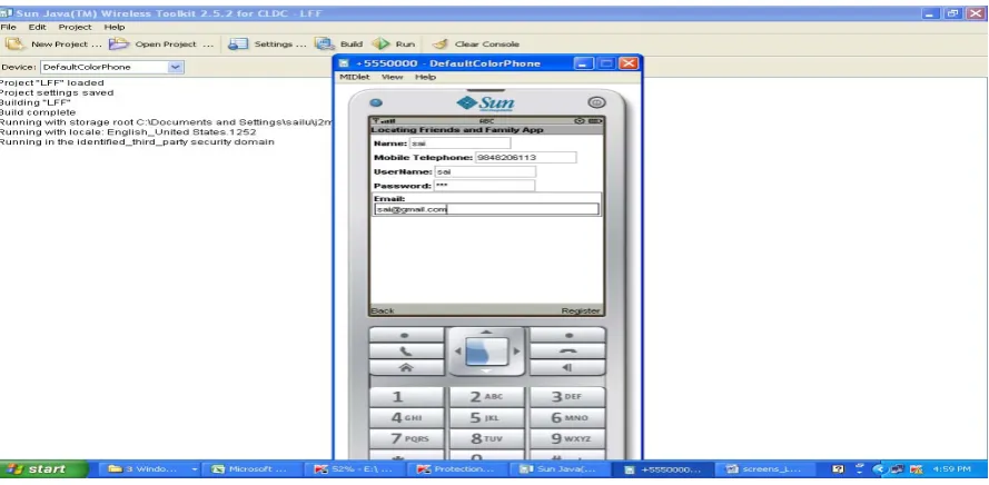
In fig.2, the screen was to enter the IP Address ID and also select the option which you want to go if the user is new to application he has to register otherwise he can select the login option to go for next page.The user has to register and avail the services, in the below fig.3, the screen states the registration details needed to avail the service.
Fig. 3. Registration Form Design
Fig. 4. Login Screen
In Fig. 4 the user can Login with his username and password to use the application. In the next step, authentication is performed.
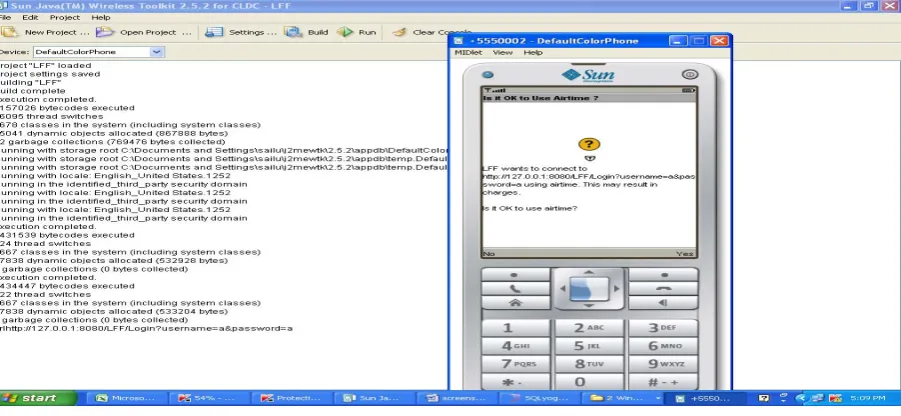
Fig. 5. Validation for the user
In Fig. 5 thedetails like user name and password of the user is validated and asks the user to connect with mobile office.
Conclusion
getting the location from the service provider by extending the radius and providing security to the radius in order to increase the capacity between the communicating mobile devices as a location tracker. We can also enhance this by using resource reservation mechanism to increase the utilization of resources that determines the location of mobile more accurately where the user is located and avoid unnecessary traffic.
References
[1] Luis C.M.Varandas. Bindo vaidya. Joel J.P.C.Rodrigues.: mTracker: A Mobile Tracking Application for Pervasive Environment, IEEE 24th
International Conference on Advanced Information Networking and Applications Workshops,2010.
[2] Ghaith Bader Al-Suwaidi and Mohamed Jamal Zemerly .: Locating Friends and Family Using Mobile Phones With Global Positioning
System (GPS), National Dong Hwa University, november 2009.
[3] Kegen Yu and Eryk Dutkiewicz .: Geometry and Motion Based Positioning Algorithms for Mobile Tracking in NLOS Environments, IEEE
Globecom 2010 proceedings.
[4] Chao-Lin Chen and Kai-Ten Feng.: Hybrid Location Estimation and Tracking System for Mobile Devices, Vehicular Technology
Conference VTC 2005.
[5] Chen Liang and Robert Piche .: Mobile Tracking and Parameter Learning in Unknown Non-line-of-sight Conditions, IEEE 2010.
[6] I, Jami. M, Ah2 and R,F, Ormondroyd.: Comparison of methods of locating and tracking cellular mobiles, published by IEEE ,Savoy place,
London 1999.
[7] Sangwoo Cho. Haekyung Jwa and Joohwan Chun. Jong Hem Lee and Yoon Seok Jung.: Mobile Position Location with the Constrained
Bootstrap Filter in a Cellular Communication System,IEEE 2000.
[8] Gowtham Mallapragada., Yicheng Wen., Shsshi Phoha., Doina Bein., Asok Ray.: Tracking targets using wireless sensor networks, seventh
International Conference on Information Technology, 2010.
[9] K. Yu and Y. J. Guo.: Improved positioning algorithms for nonline-of-sight environments,” IEEE Trans. Vehicular Technology,vol. 57, no.