Abstract
Sensor are the electronic component deployed at the specific area ,for collecting the information about that area. That information consist of geographical information, weather ,information, Temperature ,earth situation & material information present inside the earth .various work is carried for the application Of sensor nodes in all these area for gathering the information. In this paper dealing with geographical sensing of sensors nodes & overcome’s the transmition delay making the transmition of data much more reliable & quickly transmit. In this paper we are comparing the existing method used for energy consumption[1].
Keyword: signal processing component, Geographical Information System ,SINA,
1.INTRODUCTION
Remote Sensing:- Remote Sensing is the science and art of acquiring information (spectral, spatial, temporal) about material objects, area, or phenomenon, without coming into physical contact with the objects, or area, or phenomenon under investigation. Without direct contact, some means of transferring information through space must be utilized. In remote sensing, information transfer is accomplished by use of electromagnetic radiation (EMR).[2][3] EMR is a form of energy that reveals its presence by the observable effects it produces when it strikes the matter. EMR is considered to span the spectrum of wavelengths from 10-10 mm to cosmic rays up to 1010 mm, the broadcast wavelengths, which extend from0.30-15mm.
Type In respect to the type of Energy Resources: Passive Remote Sensing: Makes use of sensors that detect the reflected or emitted electro-magnetic radiation from natural, sources. Active remote Sensing: Makes use of sensors that detect reflected responses from objects that are irradiated from artificially-generated energy sources, such as radar. 1.In respect to Wavelength Regions: Remote Sensing is classified into three type sin respect to the wavelength regions
1.Visible and Reflective Infrared Remote Sensing. 2.Thermal Infrared Remote Sensing.
3.Microwave Remote Sensing
Bands Used in Remote Sensing
Emission of EMR (Electro-Magnetic Radiation) from gases is due to atoms and molecules in the gas. Atoms consist of a positively charged nucleus surrounded by orbiting electrons, which have discrete energy states[5]. Transition of electrons from one energy state to the other leads to emission of radiation at discrete wavelengths. The resulting spectrum is called line spectrum. Molecules possess rotational and vibrational energy states. Transition between which leads to emission of radiation in a band spectrum. The wavelengths, which are emitted by atoms/molecules, are also the ones, which are absorbed by them. Emission from solids and liquids occurs when they are heated and results in a continuous spectrum. This is called thermal emission and it is an important source of EMR from the viewpoint of remote sensing.
The Electro-Magnetic Radiation (EMR), which is reflected or emitted from an object, is the usual source of Remote Sensing data. However, any medium, such as gravity or magnetic fields, can be used in remote sensing. Remote Sensing Technology makes use of the wide range Electro-Magnetic Spectrum (EMS) from a very short wave "Gamma Ray" to a very long 'RadioWave'. Wavelength regions of electro-magnetic radiation have different names ranging from Gamma ray, X-ray, Ultraviolet (UV), Visible light, Infrared (IR) to Radio Wave, in order from the shorter wavelengths[7][8].
The optical wavelength region, an important region for remote sensing applications, is further subdivided as follows:
Name Wavelength
(mm)
Optical wavelength 0.30-15.0
Reflective 1.PortionVisible 2.Near IR 3.Middle IR
0.38-3.00 0.38-0.72 0.72-1.30 1.30-3.00
Far IR (Thermal, Emissive) 7.00-15.0
Microwave region (1mm to 1m) is another portion of EM spectrum that is frequently used to gather valuable remote sensing information[11].
Application of Sensor Component in Wireless
Network’s for Signal Processing with Geographical
Information
*
Surendra Bilouhan ,
**Dr. Roopam Gupta
*Sagar Institute Of Research & Technology-Excellence-Bhopal(M.P)INDIA2. BACKGROUND AND LITERATURE REVIEW
Brief His the term "remote sensing," first used in the United States in the 1950s by Ms. Evelyn Pruitt of the U.S. Office of Naval Research, is now commonly used to describe the science and art of identifying, observing, and measuring an object without coming into direct contact with it. This process involves the detection and measurement of radiation of different wavelengths reflected or emitted from distant objects or materials, by which they may be identified and categorized by class/type, substance, and spatial distribution.
The technology of modern remote sensing began with the invention of the camera more than 150 years ago. Although the first, rather primitive photographs were taken as "stills" on the ground, the idea and practice of looking down at the Earth's surface emerged in the 1840s when pictures were taken from cameras secured to tethered balloons for purposes of topographic mapping. Perhaps the most novel platform at the end of the last century is the famed pigeon fleet that operated as a novelty in Europe. By the First World War, cameras mounted on airplanes provided aerial views of fairly large surface areas that proved invaluable in military reconnaissance. From then until the early 1960s, the aerial photograph remained the single standard tool for depicting the surface from a vertical or oblique perspective. Satellite remote sensing can be traced to the early days of the space age (both Russian and American programs) and a began as a dual approach to imaging surfaces using several ty of sensors from spacecraft. In 1946, V-2 rockets acquired from Germany after World War II were launched to high altitudes White Sands, New Mexico. These rockets, while never attaining orbit, contained automated still or movie cameras that, took pictures as the vehicle ascended. Then, with the emergence of t space program in the 1960s, Earth-orbiting cosmonauts and astronauts acted much like tourists by taking photos out the window of their spacecraft[12].
3. APPLICATIONS
The applications for WSNs are varied, typically involving some kind of monitoring, tracking, or controlling. In a typical application, a WSN is deployed in a region where it is meant to collect data through its sensor nodes.
Area monitoring Area monitoring is a common application of WSNs. In area monitoring, the WSN is deployed over a region where some phenomenon is to be monitored. For example, a large quantity of sensor nodes could be deployed over a battlefield to detect enemy intrusion[13].
When the sensors detect the event being monitored (heat, pressure, sound, light, electro-magnetic field, vibration, etc.), the event is reported to one of the base stations, which then takes appropriate action (e.g., send a message on the internet or to a satellite). Similarly, wireless sensor networks can use a range of sensors to
detect the presence of vehicles ranging from motorcycles to train cars.
Figure1.Example of Area Monitoring
Environmental monitoring
A number of WSNs have been deployed for environmental monitoring[15].
Greenhouse monitoring
Wireless sensor networks are also used to control the temperature and humidity levels inside commercial greenhouses. When the temperature and humidity drops below specific levels, the greenhouse manager must be notified via e-mail or cell phone text message, or host systems can trigger misting systems, open vents, turn on fans, or control a wide variety of system responses.
Landslide detection
A landslide detection system, makes use of a wireless sensor network to detect the slight movements of soil and changes in various parameters that may occur before or during a landslide. And through the data gathered it may be possible to know the occurrence of landslides long before it actually happens.
Industrial monitoring Machine health monitoring
Wireless sensor networks have been developed for machinery condition-based maintenance (CBM)as they offer significant cost savings and enable new functionalities. In wired systems, the installation of enough sensors is often limited by the cost of wiring. Previously inaccessible locations, rotating machinery, hazardous or restricted areas, and mobile assets can now be reached with wireless sensors.
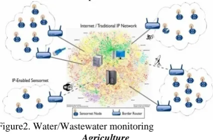
Water/Wastewater monitoring
There are many opportunities for using wireless sensor networks within the water/wastewater industries. Facilities not wired for power or data transmission can be monitored using industrial wireless I/O devices and sensors powered using solar panels or battery packs.
Landfill ground well level monitoring and pump counter
Wireless sensor networks can be used to measure and monitor the water levels within all ground wells in the landfill site and monitor leach ate accumulation and removal. A wireless device and submersible pressure transmitter monitors the leach ate level. The sensor
information is wirelessly transmitted to a central data logging system to store the level data, perform calculations, or notify personnel when a service vehicle is needed at a specific well.
Figure2.Water/Wastewater monitoring
Agriculture
Using wireless sensor networks within the agricultural industry is increasingly common. Gravity feed water systems can be monitored using pressure transmitters to monitor water tank levels, pumps can be controlled using wireless I/O devices, and water use can be measured and wirelessly transmitted back to a central control center for billing. Irrigation automation enables more efficient water use and reduces waste[10]
Figure3.Example of Agriculture
Fleet monitoring It is possible to put a mote with a module on-board of each vehicle of a fleet. The mote gathers its position via the GPS module, and reports its coordinates so that the location is tracked in real-time. The motes can be equipped with temperature sensors to avoid any disruption of the cold chain, helping to ensure the safety of food, pharmaceutical and chemical shipments. In situations where there is not reliable GPS coverage, like inside buildings, garages and tunnels, using information from GSM cells is an alternative for to GPS localization[12].
4. CHARACTERISTICS
Unique characteristics of a WSN include:
Limited power they can harvest or store Ability to withstand harsh environmental conditions
Ability to cope with node failures Coping with mobility of nodes
Dynamic network topology
Communication failures
Heterogeneity of nodes
Large scale of deployment
Unattended operation
Node capacity is scalable, only limited by bandwidth of gateway node.
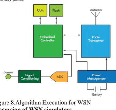
Sensor nodes can be imagined as small computers, extremely basic in terms of their interfaces and their components. They usually consist of a processing unit
with limited computational power and limited memory, sensors (including specific conditioning circuitry), a communication device (usually radio transceivers or alternatively optical), and a power source usually in the form of a battery. Other possible inclusions are energy harvesting modules, secondary ASICs, and possibly secondary communication devices (e.g. RS-232 or USB).
The base stations are one or more distinguished components of the WSN with much more computational, energy and communication resources. They act as a gateway between sensor nodes and the end user as they typically forward data from the WSN on to a server. Many techniques are used to connect to the outside world including mobile phone networks, satellite phones, radio modems, high power WiFi links etc.
Figure 4.Example of WSN Network
5. HOME APPLICATION
Along with developing commercial application of sensor network it is no so hard to image that Home application will step into our normal life in the future. Many
Figure 5.Example of Home
application widows are also attached with vibratory sensors connected to police to against thief. How nice! You become nurse and bodyguard at the same time.
Platforms Standards and specifications
number o The IEEE Internet E above. I Internatio solutions also seve specifica than in predomin communi Main art The main and tiny s of small commerc computin the resea software. the use v
Figure 6. Energy is determin be deploy including communi and proto software deployme control primitive Operating are typi of standardizat E focuses on th Engineering T In addition t onal Society s, covering all eral non-standa ations[12].Stan n other co nant standard
ications includ ISA100 IEEE 1451 ZigBee / 802. IEEE 802.11
H ticle: sensor n
n challenge in sensor nodes. companies pr cial situation ng in the 1970 arch and devel . Also inheren ery low powe
Sensor Netwo
SO
s the scarcest es the lifetime yed in large nu g remote and
ications as ke ocols need to a Lifetime m Robustness Self-config Some of th research are: Operating s Security Mobility Usability - ent and manag
Middlewar es between hig
Oper
g systems for ically less c
tion bodies in he physical an Task Force wo to these, bo of Automatio
protocol layer ard, proprietar ndards are use omputing sy ds commonly de: .15.4 Hardware ode
n a WSN is to There are an roducing WSN
can be co 0s. Many of th lopment stage nt to sensor n er method for d
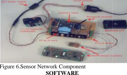
ork Componen
OFTWARE
resource of W e of WSNs. W umbers in vari d hostile reg
ey. For this r address the fo maximization
s and fault tole guration
e important to
systems
human interef gement, debug
e - the design gh level softwa
rating systems
r wireless sen complex than
the field of W nd MAC layer orks on layers dies such as on provide ve r. Finally, ther ry mechanism ed far less in W ystems. How y used in W
o produce low
increasing nu N hardware an ompared to h
he nodes are s e, particularly etwork adopti data acquisitio
nt
WSN nodes, a WSNs are mea ious environm ions, with ad reason, algori ollowing issue
erance
opics in WSN
face for gging and end
of middle-lev are and the sys
s
nsor network n n general-pu WSNs. rs; the 3 and s the ertical re are ms and WSNs wever WSN w cost umber nd the home till in y their ion is on. and it ant to ments, d-hoc ithms s: d-user vel stems nodes urpose oper embe senso parti platf leads micr virtu impl It is syste How with Tiny spec Tiny mod comp comp such Tiny the sche LiteO netw supp Figu Algo WSN node targe energ energ idle resea energ redu end, pow algor Anot to th poly trans it is statio node The analy appr mod rating system edded system or networks icular applicat form. Second, s most wirele rocontrollers ual memory ei
lement[12]. s therefore po
ems such as e wever, such op h real-time pro
yOS[8] is per ifically desig yOS is based del instead of m
posed into ev
pletion-seman h as an incom yOS signals th event. Event duled by the T OS is a newly works, which p
port for C prog
ure 7.Tiny OS
orithms
Ns are compo es, therefore, eted. WSNs a
gy is a scarc gy-expensive
listening. F arch in WSNs
rgy aware a ucing the amou techniques o er cycling a rithms. ther character he constrained ynomial grow smission with very unlikely on, so data tra e to node, tow
algorithmic a yzing WSNs d roach by the f dels used are m
ms. They mo ms, for two r are typical tion in mind, r a need for lo ess sensor nod
ensuring that ither unnecess
ossible to use eCos or uC/O
perating syste operties.
rhaps the fir gned for wire d on an even multithreading
vent handlers
ntics. When an ming data pack
he appropriate t handlers ca TinyOS kerne y developed O provides UNIX gramming lan
osed of a la
distributed
are often ener ce resource,
operations ar or this reaso s focuses on t algorithms fo
unt of data bei ften employed and the use
ristic to take i d radio transm wth in the
respect to the y that every no ansmission is u wards the base
approach to mo differentiates fact that the i more general
ore strongly reasons. First, lly deployed rather than as ow costs and lo
des to have lo t mechanisms sary or too exp
e embedded OS for sensor ems are often
rst[9] operatin eless sensor nt-driven prog g. TinyOS pro
and tasks wi n external eve ket or a senso event handler an post tasks el some time la
S for wireless X like abstract
guage.
arge number
algorithms
rgy-constraine and one of e data transmi on, much al the study and or saving en ing transmitte d are data agg
of topology
into account i mission range
energy-cost e transmission
ode will reach usually multi-h
stations). odeling, simu itself from the idealized mat
and easier to
resemble , wireless d with a
a general ow power ow-power s such as pensive to operating networks. n designed g system networks. gramming ograms are ith run to ent occurs, r reading, r to handle s that are
ater[11]. s sensor
tion and
of sensor are often ed, that is,
the most ission and lgorithmic design of nergy by ed. To this
gregation, y control
s that due e and the of radio n distance,
h the base hop (from
lating and e protocol
thematical o analyze.
However, they are sometimes less realistic than the models used for protocol design, since an algorithmic approach often neglects timing issues, protocol overhead, the routing initiation phase and sometimes distributed implementation of the algorithms.
Figure 8.Algorithm Execution for WSN
Discussion of WSN simulators
There are network simulator platforms specifically designed to model and simulate Wireless Sensor Networks, like TOSSIM, which is a part of TinyOS and COOJA which is a part of Contiki. Traditional network simulators like ns-2 have also been used. Ns-3, which is an upgrade over Ns-2 is expected to be released shortly, also features WSN libraries[9][11] Network Simulators like QualNet, Opnet, NetSim and NS2 can be used to simulate Wireless Sensor Network. Other simulators, like IDEA1 -based on SystemC- have hardware-level libraries that permits system-level simulations by taking low-level constraints into account.Based on Matlab, the Prowler (Probabilistic Wireless Network Simulator) toolbox is available.
Distributed sensor network
If a centralised architecture is used in a sensor network and the central node fails, then the entire network will collapse, however the reliability of the sensor network can be increased by using distributed architecture.Distributed architecture is used in WSNs for the following reasons:
.Sensor nodes are prone to failure, 1.For better collection of data
2.To provide nodes with backup in case of failure of the central node
We also take care of nodes sensing redundant information and forwarding the data that is of no use. There is also no centralized body to allocate the resources and they have to be self organized.
Data visualization
The data gathered from wireless sensor networks is usually saved in the form of numerical data in a central base station. Additionally, the Open Geospatial Consortium (OGC) is specifying standards for interoperability interfaces and metadata encodings that enable real time integration of heterogeneous sensor
webs into the Internet, allowing any individual to monitor or control Wireless Sensor Networks through a Web Browser.
Information fusion
In wireless sensor networks, information fusion, also called data fusion, has been developed for processing sensor data by filtering, aggregating, and making inferences about the gathered data. Information fusion deals with the combination of multiple sources to obtain improved information: cheaper, greater quality or greater relevance[10]. Within the wireless sensor networks domain, simple aggregation techniques such as maximum, minimum, and average, have been developed for reducing the overall data traffic to save energy[3][5].
CONCLUSION
In this paper we are presenting the some of the major application where the sensor component are used in a effective manner and saving the time , and man power resource , these application’s are costly but some very meaning full updation of implementation of electronics compound is done , this work is just a review of some of the well known application of sensor network,Some of the network simulator and previous work is also study in this paper
REFERENCES
1.Dargie, W. and Poellabauer, C., "Fundamentals of wireless sensor networks: theory and practice", John Wiley and Sons, 2010 ISBN 978-0-470-99765-9, p, 168-183, 191-192
2.Sohraby, K., Minoli, D., Znati, T. "Wireless sensor networks: technology, protocols, and applications, John Wiley and Sons", 2007 ISBN 978-0-471-74300-2, p. 203-209
3.Tiny OS website
4.TinyOS Programming, Philip Levis, Cambridge University Press, 2009
5.Eduardo F. Nakamura, Antonio A. F. Loureiro, Alejandro C. Frery. Information fusion for wireless sensor networks: Methods, models, and classifications, ACM Computing Surveys, Volume 39, Issue 3, Article 9, September 2007.
6.Eduardo F. Nakamura, Heitor S. Ramos, Leandro A. Villas, Horacio A.B.F. de Oliveira, Andre L.L. de Aquino, Antonio A.F. Loureiro. A reactive role assignment for data routing in event-based wireless sensor networks, Computer Networks Volume 53, Issue 12, pp 1980-1996, August 2009.
7. “21 ideas for the 21st century,” Business Week, pp. 78-167, Aug.39, 1999.
8.http://en.wikipedia.org/wiki/Sens or_Networks
9.Akyildiz, I.F.,W. Su, Y. Sankarasubramaniam, E. Cayirci, "A Survey on Sensor
10.Networks",IEEE Communications Magazine, August, 102-114(2002).
11.Chee-Yee Chong; Kumar, S.P., "Sensor networks: Evolution, opportunities, and challenges,"Proc IEEE, August 2003 12.Container and Truck Trailer Security
13.Brinckerhoff Quade and Douglas, Inc
14.http://www.sensornetworks.net.au/applic_health.html
15.Intel wireless vineyard, www.intel.com/technology/techresearch/research/ rs01031.htm.
16.J. Burrel, T. Brooke and R. Beckwith, “Vineyard Computing: Sensor Networks in Agriculture Production”, Pervasive Computing, IEEE Volume 3, Issue 1, Jan.-March 2004 Page(s):38 - 45 17.Polly Huang, “Sensor Networks Solutions to Real Life Problems” http://cc.ee.ntu.edu.tw/ ~phuang .